Related Research Articles

Angus is one of the 32 local government council areas of Scotland, a registration county and a lieutenancy area. The council area borders Aberdeenshire, Dundee City and Perth and Kinross. Main industries include agriculture and fishing. Global pharmaceuticals company GSK has a significant presence in Montrose in the north of the county.

The Battle of Dun Nechtain or Battle of Nechtansmere was fought between the Picts, led by King Bridei Mac Bili, and the Northumbrians, led by King Ecgfrith, on 20 May 685.

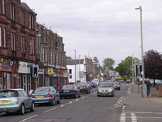
Carnoustie is a town and former police burgh in the council area of Angus, Scotland. It is at the mouth of the Barry Burn on the North Sea coast. In the 2011 census, Carnoustie had a population of 11,394, making it the fourth-largest town in Angus. The town was founded in the late 18th century, and grew rapidly throughout the 19th century due to the growth of the local textile industry. It was popular as a tourist resort from the early Victorian era up to the latter half of the 20th century, due to its seaside location, and is best known for the Carnoustie Golf Links course that often hosts the Open Championship.

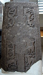
A Pictish stone is a type of monumental stele, generally carved or incised with symbols or designs. A few have ogham inscriptions. Located in Scotland, mostly north of the Clyde-Forth line and on the Eastern side of the country, these stones are the most visible remaining evidence of the Picts and are thought to date from the 6th to 9th century, a period during which the Picts became Christianized. The earlier stones have no parallels from the rest of the British Isles, but the later forms are variations within a wider Insular tradition of monumental stones such as high crosses. About 350 objects classified as Pictish stones have survived, the earlier examples of which holding by far the greatest number of surviving examples of the mysterious symbols, which have long intrigued scholars.

Aberlemno is a parish and small village in the Scottish council area of Angus. It is noted for three large carved Pictish stones dating from the 7th and 8th centuries AD ; the stones can be viewed at any time in spring-autumn, but are covered by wooden boxes in the winter to prevent frost damage. Two stones stand by the B9134 Forfar-Brechin road, the Kirkyard Stone stands in the nearby graveyard of the parish church.
Monifieth is a town and former police burgh in the council area of Angus, Scotland. It is situated on the north bank of the Firth of Tay on the east coast. In 2016, the population of Monifieth was estimated at 8,110, making it the fifth largest town in Angus.

The Hilton of Cadboll Stone is a Class II Pictish stone discovered at Hilton of Cadboll, on the East coast of the Tarbat Peninsula in Easter Ross, Scotland. It is one of the most magnificent of all Pictish cross-slabs. On the seaward-facing side is a Christian cross, and on the landward facing side are secular depictions. The latter are carved below the Pictish symbols of crescent and v-rod and double disc and Z-rod: a hunting scene including a woman wearing a large penannular brooch riding side-saddle. Like other similar stones, it can be dated to about 800 AD.
Arbirlot is a village in a rural parish of the same name in Angus, Scotland. The current name is usually presumed to be a contraction of Aberelliot or Aber-Eliot - both meaning the mouth of the Elliot. It is situated west of Arbroath. The main village settlement is on the Elliot Water, 2+1⁄2 miles (4 km) from Arbroath. There is a Church of Scotland church and a primary school. The school lies 1 mile (1.6 km) further west, in the approximate geographic centre of the parish.

Menmuir is a parish in the county of Angus in Scotland.

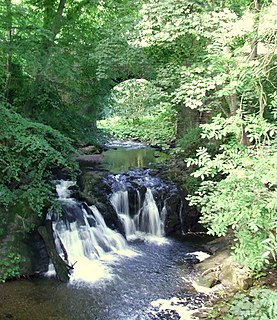
The Eassie Stone is a Class II Pictish stone of about the mid 8th century AD in the village of Eassie, Angus, Scotland. The stone was found in Eassie burn in the late 18th century and now resides in a purpose-built perspex building in the ruined Eassie church.
The Battle of Barry is a legendary battle in which the Scots, purportedly led by Malcolm II, defeated a Danish invasion force in 1010 AD. Its supposed site in Carnoustie, Angus can be seen in early Ordnance Survey maps. The history of the event relies heavily on tradition and it is currently considered to be apocryphal. The battle was named for the Parish of Barry, rather than the village, and was formerly thought to have taken place at the mouth of the Lochty burn, in the vicinity of the area that is now occupied by Carnoustie High Street. While the battle is not historically authentic, its romantic appeal continues to capture the popular imagination.

Thomas Lowson is traditionally thought to be the founder of the town of Carnoustie, Angus.

The Camus Cross, otherwise known as the Camuston or Camustane Cross, is an Early Medieval Scottish standing stone on the Panmure Estate near Carnoustie in Angus, Scotland. First recorded in the 15th century in a legal document describing the boundaries between Camuston and the barony of Downie, and described in the 17th century by Robert Maule, it is a freestanding cross, rare in Eastern Scotland.

The Monifieth Sculptured Stones are a series of five class II and III standing Pictish stones from the early Medieval period found in or around St Regulus' church in Monifieth, Angus, Scotland. Uncovered during the demolition of a pre-Reformation church and its kirkyard wall in the 19th and 20th centuries, the stones are now housed in the collection of the Museum of Scotland.
The Aberlemno Sculptured Stones are a series of five Class I and II Early Medieval standing stones found in and around the village of Aberlemno, Angus, Scotland.
Carlogie is a hamlet in Angus, Scotland. It lies approximately half a mile north of Carnoustie on the A930 road. Carlogie House was erected in 1854 as the residence of the factor of Panmure Estate. It was converted into a hotel in the 1960s by James Robson. Planning consent was granted to convert it into residential housing in 2007.
Woodhill is a settlement in Angus, Scotland. It lies at a central point between Carnoustie and Monifieth on the east on an unclassified road linking the A92 and A930 roads. Woodhill House was erected in 1604 by William Auchinleck, who later became Provost of Dundee. It was demolished and rebuilt in 1908.
The Woodwrae Stone is a Class II Pictish Stone that was found in 1819 when the foundations of the old castle at Woodwrae, Angus, Scotland were cleared. It had been reused as a floor slab in the kitchen of the castle. Following its removal from the castle, it was donated to the collection of Sir Walter Scott at Abbotsford House. It is now on display at the Museum of Scotland in Edinburgh.
Carnoustie High School is a comprehensive secondary school in Carnoustie, Angus, Scotland. Situated to the north of the town, the school serves Carnoustie and surrounding villages, including Barry, Monikie, Newbigging, Craigton, Muirdrum, Panbride and Easthaven.
Brechin Monastery was a Culdee religious house located in the county of Angus in Scotland. It was founded during the reign of Kenneth II (971–995). No trace of the building remains today.
References
- Hector Boece. 1527. Historia Gentis Scotorum (History of the Scottish People)
- John Carrie. 1881. Ancient Things in Angus: A Series of Articles on Ancient Things, Manners, and Customs, in Forfarshire, published by Thomas Buncle, 156 pages