Canton of Basel

Last updated
Canton of Basel
Kanton Basel
Canton of the Old Swiss Confederacy, of the Helvetic Republic and of Restoration Switzerland
1501–1833
Flag of Canton of Basel.svg
Flag
Wappen Basel-Stadt matt.svg
Coat of arms
Helvetische Republik (Nord) 1802.png
The canton of Basel, shown within the northern part of the Helvetic Republic, as at 1802; the canton of Fricktal (adjacent) joined the Aargau later that year.
Capital Basel
History
History 
1501
15 May 1648
1792–1793
1798–1802
 Partition into half-cantons
16 August 1833
Preceded by
Succeeded by
Wappen Bistum Basel.svg Bishopric of Basel
Basel-City Wappen Basel-Stadt matt.svg
Basel-Country BaleCampagne-coat of arms.svg

Basel was a canton of Switzerland that was in existence between 1501 and 1833, when it was split into the two half-cantons of Basel-City and Basel-Country. [1]

Contents

Background

The Prince-Bishopric of Basel in the 16th century Fuerstbistum Basel 16Jh.png
The Prince-Bishopric of Basel in the 16th century

Before the Protestant Reformation, Basel was ruled by prince-bishops (see Bishop of Basel, whose memory is preserved in the crosier shown on the Basel coat of arms, as above). In the later 15th century, in the wake of the Council of Basel (1431–49), the city of Basel grew in wealth and importance. The University of Basel was established in 1459, and the city became an intellectual center of the German Renaissance in the years leading up to the Reformation. Erasmus of Rotterdam taught in Basel, and early printshops were set up by Johannes Petri and Johann Froben. In 1495, Basel was incorporated in the Upper Rhenish Imperial Circle, the bishop sitting on the Bench of the Ecclesiastical Princes.

Establishment

As a direct consequence of the Swabian War, resolved by the 1499 Treaty of Basel, Basel and the Imperial City of Schaffhausen joined the Swiss Confederation in 1501, as the confederacy's 11th and 12th states, with Appenzell following suit 12 years later to complete the Dreizehn Orte that made up Switzerland until the French Revolutionary Wars.

The canton of Basel seceded from the prince-bishopric, and the secular rule of the bishops of Basel from this time was limited to territories west of Basel, more or less corresponding to the modern canton of Jura. Even though the bishops of Basel no longer held secular authority over the city of Basel, they continued to reside in the city until the Protestant Reformation.

Reformation

In 1503, the new bishop Christoph von Utenheim refused to give Basel a new constitution whereupon, to show its power, the city began the construction of a new city hall. [2] The reformation was brought to Basel by Johannes Oecolampadius cathedral preacher under von Utenheim and co-editor of Erasmus' first edition of the Greek New Testament. Von Utenheim resigned on 19 February 1527. He was succeeded by Philippe von Gundelsheim, canon at Basel Münster since 1510.

In 1529, the city became Protestant under Oecolampadius and the bishop's seat was moved to Porrentruy. In 1530, Laufental rebelled against the bishop, but were suppressed using forces from Solothurn. Because of insolvency, the prince-bishopric grew increasingly dependent on the city of Basel, with the city granting him a mortgage on Birseck Castle in 1542, 1544, and 1545. In 1547, the bishop formally agreed to allow the city to choose its own religion, recognizing that the city had already become Protestant. [3]

The Basel patriciate ("Daig") now played a pivotal role in city affairs as they gradually established themselves as a de facto city aristocracy. The Bernoulli family, which included important 17th- and 18th-century mathematicians such as Jakob Bernoulli, Johann Bernoulli and Daniel Bernoulli, were from Basel. The 18th-century mathematician Leonhard Euler was born in Basel and studied under Johann Bernoulli.

Intended as a defence of Huguenots then persecuted in France, Calvin's Institutes, authored in Basel, was a 1536 exposition of Protestant Christian doctrine which later became known as Calvinism.

Map of Basel in 1642, engraved by Matthaus Merian, oriented with SW at the top and NE at the bottom. Merian Basel 1642.jpg
Map of Basel in 1642, engraved by Matthäus Merian, oriented with SW at the top and NE at the bottom.

The first edition of Christianae religionis institutio ( Institutes of the Christian Religion John Calvin's great exposition of Calvinist doctrine) was published at Basel in March 1536. [4] In 1543, De humani corporis fabrica , the first book on human anatomy, was published and printed in Basel by Andreas Vesalius (1514–1564). [5]

The 1648 Peace of Westphalia finally brought about Imperial recognition of the independence of the Swiss cantons, removing the de jure (but not de facto) overlordship of the Holy Roman Empire rejected by the then–Prince-Bishopric nearly 150 years earlier.

Unrest and insurrection

In 1792, the Rauracian Republic, a revolutionary French client republic, was created, lasting for a few months into the following year before being partitioned between a restored canton of Basel, later within the Helvetic Republic, and the First French Republic.

Until 1830, Basel was a unified canton, with citizens from both the city and the municipalities of the countryside sitting in the Kantonsparlament. The cantonal parliament was dominated by members from the city, though its population was less than that of the combined countryside. This had not previously been a source of grievance, but in 1830 the Baselbieter, or citizens from the countryside, grew increasingly distrustful of the city. At a meeting in Bad Bubendorf on 18 October 1830, 25 Baselbieter wrote to the "esteemed gentlemen and noblemen in Basel", demanding equal rights between city and countryside and a representation in parliament in proportion to their numbers.

When the city rejected this demand, resentment from the countryside region grew still larger to the extent that the city feared an attack. In Liestal a few men of the countryside formed a new provincial government protected by an army of 3,000. The government was however short-lived as on 16 January 1831 a force from Basel occupied Liestal, driving out the new government. A number of villages, such as Gelterkinden, Reigoldswil, Anwil and Bubendorf remained loyal to Basel, though coming under threat from the rebels. The unrest in the countryside persisted into 1832 and both sides committed injustices upon the other.

On 3 August 1833 over 1200 troops of the city armed with 14 cannons marched on Liestal, but at the Battle of Hülftenschanz, which took place between Pratteln and Frenkendorf, the city's troops were forced back to Basel by the superior numbers of the rebels. Their route back to the city was ambushed and the city forces took heavy losses.

Partition

A cantonal coat of arms combining the coats of arms of the two half cantons, was in use from 1833 to 1999 when the "full canton" needed representation, e.g. in the Standesscheiben shown in the glass dome of the Federal Palace of Switzerland. The same combined coat of arms would be used for the suggested re-united canton. Basel.png
A cantonal coat of arms combining the coats of arms of the two half cantons, was in use from 1833 to 1999 when the "full canton" needed representation, e.g. in the Standesscheiben shown in the glass dome of the Federal Palace of Switzerland. The same combined coat of arms would be used for the suggested re-united canton.

After this conflict, the highest Swiss authority, the Tagsatzung , was petitioned on 17 August 1833 to separate the canton of Basel; nine days later, the partition into half-cantons, modelled after the precedent of Unterwalden and Appenzell, was effected.

From the country municipalities it allocated only Riehen, Bettingen and Kleinhüningen — which would otherwise have been an exclave of Basel-Country between Basel-City and the Grand Duchy of Baden — to the new half-canton of Basel-City. The remaining municipalities formed the new canton of Basel-Country.

The Swiss Constitution of 1844 continued to recognize "Basel" as one of twenty-two "sovereign cantons" of Switzerland, enumerated as Basel (Stadt und Land). In this sense, as a sovereign member of the Swiss Confederacy, the canton of Basel continued to exist until 1999, when the revised constitution recognised the two former half-cantons as "cantons" for the first time.

Suggested re-unification

Several attempts have been made to reunite Basel-City and Basel-Country. In 1969, the citizens of Basel-Country defeated the motion in a referendum. The two cantons have since concluded a number of co-operation agreements, such as joint financing and governance of the University of Basel.

Related Research Articles

<span class="mw-page-title-main">Basel</span> City in Switzerland

Basel, also known as Basle, is a city in northwestern Switzerland on the river Rhine. Basel is Switzerland's third-most-populous city with about 175,000 inhabitants. The official language of Basel is German, but the main spoken language is the local Basel German dialect.

<span class="mw-page-title-main">Basel-Landschaft</span> Canton of Switzerland

Basel-Landschaft or Basel-Country, informally known as Baselland or Baselbiet, is one of the 26 cantons forming the Swiss Confederation. It is composed of five districts and its capital city is Liestal. It is traditionally considered a "half-canton", the other half being Basel-Stadt, its urban counterpart.

<span class="mw-page-title-main">Johannes Oecolampadius</span> German Protestant reformer

Johannes Oecolampadius was a German Protestant reformer in the Calvinist tradition from the Electoral Palatinate. He was the leader of the Protestant faction in the Baden Disputation of 1526, and he was one of the founders of Protestant theology, engaging in disputes with Erasmus, Zwingli, Luther and Martin Bucer. Calvin adopted his view on the Eucharist dispute.

<span class="mw-page-title-main">Cantons of Switzerland</span> Member states of the Swiss Confederation

The 26 cantons of Switzerland are the member states of the Swiss Confederation. The nucleus of the Swiss Confederacy in the form of the first three confederate allies used to be referred to as the Waldstätte. Two important periods in the development of the Old Swiss Confederacy are summarized by the terms Acht Orte and Dreizehn Orte.

<span class="mw-page-title-main">Appenzell Innerrhoden</span> Canton of Switzerland

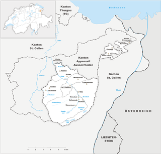
Appenzell Innerrhoden, in English sometimes Appenzell Inner-Rhodes, is one of the 26 cantons forming the Swiss Confederation. It is composed of six districts. The seat of the government and parliament is Appenzell. It is traditionally considered a "half-canton", the other half being Appenzell Ausserrhoden.

<span class="mw-page-title-main">Appenzell Ausserrhoden</span> Canton of Switzerland

Appenzell Ausserrhoden, in English sometimes Appenzell Outer Rhodes, is one of the 26 cantons forming the Swiss Confederation. It is composed of twenty municipalities. The seat of the government and parliament is Herisau, and the seat of judicial authorities are in Trogen. It is traditionally considered a "half-canton", the other half being Appenzell Innerrhoden.

<span class="mw-page-title-main">Appenzell</span> Historical canton of Switzerland

Appenzell was a canton in the northeast of Switzerland, and entirely surrounded by the canton of St. Gallen, in existence from 1403 to 1597.

<span class="mw-page-title-main">Flags and arms of cantons of Switzerland</span>

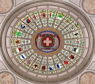
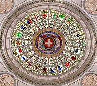
Each of the 26 modern cantons of Switzerland has an official flag and a coat of arms. The history of development of these designs spans the 13th to the 20th centuries.

<span class="mw-page-title-main">Reformation in Switzerland</span> Protestant Reformation in Switzerland

The Protestant Reformation in Switzerland was promoted initially by Huldrych Zwingli, who gained the support of the magistrate, Mark Reust, and the population of Zürich in the 1520s. It led to significant changes in civil life and state matters in Zürich and spread to several other cantons of the Old Swiss Confederacy. Seven cantons remained Catholic, however, which led to intercantonal wars known as the Wars of Kappel. After the victory of the Catholic cantons in 1531, they proceeded to institute Counter-Reformation policies in some regions. The schism and distrust between the Catholic and the Protestant cantons defined their interior politics and paralysed any common foreign policy until well into the 18th century.

<span class="mw-page-title-main">Early Modern Switzerland</span> Aspect of history

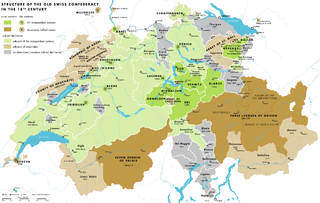
The early modern history of the Old Swiss Confederacy and its constituent Thirteen Cantons encompasses the time of the Thirty Years' War (1618–1648) until the French invasion of 1798.

<span class="mw-page-title-main">Roman Catholic Diocese of Chur</span> Latin Catholic jurisdiction in Switzerland

The Diocese of Chur is a Latin Church ecclesiastical territory or diocese of the Catholic Church in Switzerland. It extends over the Swiss Cantons of Graubünden (Grisons), Schwyz, Glarus, Zurich, Nidwalden, Obwalden and Uri.

Christoph von Utenheim was Bishop of Basel from 1502 until his resignation from that office in 1527.

<span class="mw-page-title-main">Old Swiss Confederacy</span> Confederation of cantons from 1291–1798 that was a predecessor state of the Helvetic Republic

The Old Swiss Confederacy or Swiss Confederacy was a loose confederation of independent small states, initially within the Holy Roman Empire. It is the precursor of the modern state of Switzerland.

<span class="mw-page-title-main">Prince-Bishopric of Constance</span> Principality of the Holy Roman Empire

The Prince-Bishopric of Constance, was a small ecclesiastical principality of the Holy Roman Empire from the mid-12th century until its secularisation in 1802–1803. In his dual capacity as prince and as bishop, the prince-bishop also governed the Diocese of Konstanz, which existed from about 585 until its dissolution in 1821, and whose territory extended over an area much larger than the principality. It belonged to the ecclesiastical province of Mainz since 780/782.

<span class="mw-page-title-main">Prince-Bishopric of Basel</span> Ecclesiastical principality within the Holy Roman Empire

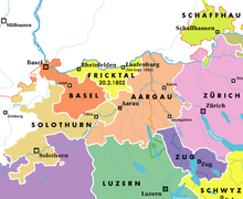
The Prince-Bishopric of Basel was an ecclesiastical principality within the Holy Roman Empire, ruled from 1032 by prince-bishops with their seat at Basel, and from 1528 until 1792 at Porrentruy, and thereafter at Schliengen. As an imperial estate, the prince-bishop had a seat and voting rights at the Imperial Diet. The final dissolution of the state occurred in 1803 as part of the German Mediatisation.

Wilhelm Eduard Brodtbeck was a Swiss architect from Liestal canton Basel-Country.

Switzerland, officially the Swiss Confederation, is a collection of semi-autonomous cantons. As membership of the confederation has fluctuated throughout history, each of these cantons has its own unique history and nobility. Typically, each canton had its own constitution, currency, jurisdiction, habits, customs, history, and nobility.

<span class="mw-page-title-main">Rappenkrieg (Basel)</span>

The Rappenkrieg was a peasant uprising lasting from 1591–1594, involving a conflict between the Swiss city of Basel and the surrounding Prince-Bishopric of Basel.

<span class="mw-page-title-main">German-speaking Switzerland</span> Part of Switzerland

The German-speaking part of Switzerland comprises about 65 percent of Switzerland.

Philippe von Gundelsheim (1487–1553) was the Prince-Bishop of Basel from 1527 to 1553.

References

  1. The term "half-canton" refers to the constitutional status of these entities during 18481999. Since 1999, they are officially "cantons" with "half-vote" in the Council of States (je eine halbe Standesstimme, Swiss Constitution of 1999, paragraph 142.4)
  2. Habicht, Peter, Basel - A Center at the Fringe (Basel: Christoph Merian Verlag, 2006) pp. 43, 55, 70, 79.
  3. Surchat, Pierre Louis, „Philipp von Gundelsheim“, in: Neue Deutsche Biographie 20 (2001), S. 373 f. [Onlinefassung]; URL: http://www.deutsche-biographie.de/pnd100536808.html
  4. Geoffrey Rudolph Elton, Harold Fullard, Henry Clifford Darby, Charles Loch Mowat, The New Cambridge Modern History , 1990, p. 113
  5. The Illustrations from the Works of Andreas Vesalius of Brussels, Courier Dover Publications 1973, p.30

Coordinates: 47°33′N7°34′E / 47.550°N 7.567°E / 47.550; 7.567