
Government Communications Headquarters (GCHQ) is an intelligence and security organisation responsible for providing signals intelligence (SIGINT) and information assurance (IA) to the government and armed forces of the United Kingdom. Primarily based at "The Doughnut" in the suburbs of Cheltenham, GCHQ is the responsibility of the country's Secretary of State for Foreign and Commonwealth Affairs, but it is not a part of the Foreign Office and its Director ranks as a Permanent Secretary.
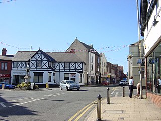
Neston is a market town and civil parish on the Wirral Peninsula, in Cheshire, England. It is part of the unitary authority of Cheshire West and Chester. The civil parish and wider suburban area includes Parkgate to the north west and Little Neston, Ness and part of Burton to the south.

Royal Air Force Menwith Hill is a Royal Air Force station near Harrogate, North Yorkshire, England, which provides communications and intelligence support services to the United Kingdom and the United States. The site contains an extensive satellite ground station and is a communications intercept and missile warning site. It has been described as the largest electronic monitoring station in the world.
Zircon was the codename for a British signals intelligence satellite, designed to intercept radio and other signals from the USSR, Europe and other areas. It was intended to be launched in 1988 on a NASA space shuttle. However, the project was cancelled in 1987 because of its cost. Secrecy about the project's cost, hidden from the British Parliament, resulted in the Zircon affair.

Tranmere is a suburb of Birkenhead, on the Wirral Peninsula, England. Administratively, it is within the Birkenhead and Tranmere Ward of the Metropolitan Borough of Wirral, in Merseyside. Before local government reorganisation on 1 April 1974, it was part of the County Borough of Birkenhead, within the county of Cheshire.

The Wirral Peninsula, known locally as the Wirral, is a peninsula in North West England. The roughly rectangular peninsula is about 15 miles (24 km) long and 7 miles (11 km) wide, and is bounded by the Dee Estuary to the west, the Mersey Estuary to the east, and Liverpool Bay to the north.

Upton-by-Chester is a civil parish and a large suburb on the outskirts of Chester, in the unitary authority of Cheshire West and Chester and the ceremonial county of Cheshire, England. It includes the villages of Upton and Upton Heath.
Caldy is a small, affluent village on the Wirral Peninsula, England, south-east of West Kirby. It is part of the West Kirby & Thurstaston Ward of the Metropolitan Borough of Wirral and is in the parliamentary constituency of Wirral West. At the time of the 2001 Census, Caldy had 1,290 inhabitants, of a total ward population of 12,869.

Mollington is a village and civil parish in the unitary authority of Cheshire West and Chester and the ceremonial county of Cheshire, England. It is two miles north of the city of Chester, with the A41 Liverpool–Chester trunk road and Shropshire Union Canal to the east and southeast, the A540 Wirral peninsula trunk road to the south and west and the A5117 link road to the north. Nearby settlements include Backford, Blacon, Capenhurst and Saughall.
The Urenco Group is a British-German-Dutch nuclear fuel consortium operating several uranium enrichment plants in Germany, the Netherlands, United States, and United Kingdom. It supplies nuclear power stations in about 15 countries, and states that it had a 29% share of the global market for enrichment services in 2011. Urenco uses centrifuge enrichment technology.

Thurstaston is a village and former civil parish, in the Wirral district, in Merseyside, England, on the Wirral Peninsula. It is part of the West Kirby and Thurstaston Ward and the parliamentary constituency of Wirral West. The village lies on the A540 road between Heswall and Caldy, although it extends some distance down Station Road to the Wirral Way and the River Dee estuary.

Hooton is a suburban village and former civil parish on the Wirral Peninsula, within the unitary authority of Cheshire West and Chester and the ceremonial county of Cheshire, England. It was once a separate village but was incorporated into Ellesmere Port as the town expanded outwards during the twentieth century.

Great Sutton is a village on the Wirral Peninsula, in the unitary authority area of Cheshire West and Chester and the ceremonial county of Cheshire, England. It is a suburb of Ellesmere Port and, as with Little Sutton to the north, was once a separate village that was incorporated into the town as it expanded outwards.

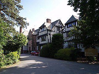
Woodbank is a village and former civil parish, now in the parish of Puddington, in the unitary authority of Cheshire West and Chester and the ceremonial county of Cheshire in northwest England. It is located on the Wirral Peninsula, about 6 miles northwest of the city of Chester and near the larger village of Saughall. In 2001 the parish had a population of 62.
The British Telecom microwave network was a network of point-to-point microwave radio links in the United Kingdom, operated at first by the General Post Office, and subsequently by its successor BT plc. From the late 1950s to the 1980s it provided a large part of BT's trunk communications capacity, and carried telephone, television and radar signals and digital data, both civil and military. Its use of line-of-sight microwave transmission was particularly important during the Cold War for its resilience against nuclear attack. It was rendered obsolete, at least for normal civilian purposes, by the installation of a national optical fibre communication network with considerably higher reliability and vastly greater capacity.
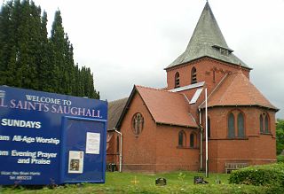
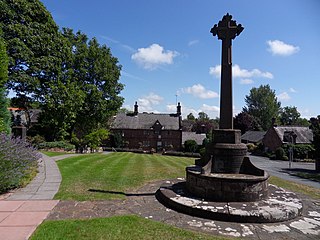
Saughall is a village and former civil parish in the unitary authority area of Cheshire West and Chester and the ceremonial county of Cheshire, England. Located between Shotwick and Blacon, it is approximately 4.8 km (3.0 mi) north west of Chester and 1.8 km (1.1 mi) from Sealand across the Welsh border.
Ledsham is a village and civil parish in the unitary authority of Cheshire West and Chester and the ceremonial county of Cheshire, England. The civil parish includes parts of the hamlets of Badger's Rake and Two Mills. It is located on the Wirral Peninsula, approximately 10 km (6.2 mi) to the north of the city of Chester and 6 km (3.7 mi) to the west of Ellesmere Port.

Cheshire West and Chester is a local government district with borough status in Cheshire, England. It was established on 1 April 2009 as part of the 2009 local government changes, by virtue of an order under the Local Government and Public Involvement in Health Act 2007. It superseded the boroughs of Ellesmere Port and Neston, Vale Royal and the City of Chester; its council is a unitary authority, having also assumed the functions and responsibilities of the former Cheshire County Council within its area. The remainder of ceremonial Cheshire is composed of Cheshire East, Halton and Warrington. Cheshire West and Chester has three key urban areas: Chester, Ellesmere Port and Northwich/Winsford.

Ince Power Station refers to two demolished power stations near Ellesmere Port in Cheshire, North West England.
Woodhead Hall is a country house at Cheadle in Staffordshire. It is a Grade II listed building.

