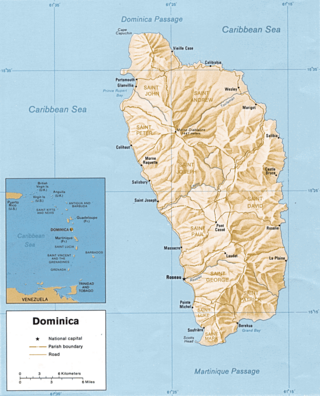
Dominica is an island in the Caribbean Sea, located about halfway between the French islands of Guadeloupe and Martinique. Its coordinates are 15 25 N, 61 20 W. It is known as "The Nature Island of the Caribbean" due to its spectacular, lush, and varied flora and fauna, which is protected by an extensive natural park system. It is the fourth largest island in the Eastern Caribbean with a population of people mainly of African descent.

A waterfall is any point in a river or stream where water flows over a vertical drop or a series of steep drops. Waterfalls also occur where meltwater drops over the edge of a tabular iceberg or ice shelf.

Macon County is a county located in the U.S. state of North Carolina. As of the 2020 census, the population was 37,014. Its county seat is Franklin.

Yosemite Falls is the highest waterfall in Yosemite National Park, dropping a total of 2,425 feet (739 m) from the top of the upper fall to the base of the lower fall. Located in the Sierra Nevada of California, it is a major attraction in the park, especially in late spring when the water flow is at its peak.

Yoho National Park is a national park of Canada. It is located within the Rocky Mountains along the western slope of the Continental Divide of the Americas in southeastern British Columbia, bordered by Kootenay National Park to the south and Banff National Park to the east in Alberta. The word Yoho is a Cree expression of amazement or awe, and it is an apt description for the park's spectacular landscape of massive ice fields and mountain peaks, which rank among the highest in the Canadian Rockies.

Multnomah Falls is a waterfall located on Multnomah Creek in the Columbia River Gorge, east of Troutdale, between Corbett and Dodson, Oregon, United States. The waterfall is accessible from the Historic Columbia River Highway and Interstate 84. Spanning two tiers on basalt cliffs, it is the tallest waterfall in the state of Oregon at 620 ft (189 m) in height. The Multnomah Creek Bridge, built in 1914, crosses below the falls, and is listed on the National Register of Historic Places.

Bash Bish Falls, a waterfall in Bash Bish Falls State Park in the Taconic Mountains of southwestern Massachusetts, is the highest waterfall in the state. The falls are made up of a series of cascades, nearly 200 feet (61 m) in total. The final cascade is split into twin falls by a jutting rock, dropping in a 59-foot (18 m) "V" over boulders to a serene pool below.

The Tahquamenon Falls State Park is a 46,179-acre (186.88 km2) state park in the U.S. state of Michigan. It is the second largest of Michigan's state parks. Bordering on Lake Superior, most of the park is located within Whitefish Township in Chippewa County, with the western section of the park extending into McMillan Township in Luce County. The nearest town of any size is Paradise.

The Liberty Bridge is a pedestrian bridge in Greenville, South Carolina. It is located at Falls Park on the Reedy, where it crosses the Reedy River above the Reedy River Falls.
Guadeloupe National Park is a national park in Guadeloupe, an overseas department of France located in the Leeward Islands of the eastern Caribbean region. The Grand Cul-de-Sac Marin Nature Reserve is a marine protected area adjacent to the park and administered in conjunction with it. Together, these protected areas comprise the Guadeloupe Archipelago biosphere reserve.

The Cumbres de Monterrey is a national park of Mexico located in the northern portion of the Sierra Madre Oriental in the states of Nuevo León and Coahuila, near the city of Monterrey. The park protects more than 1,770 square kilometres (680 sq mi) of rugged terrain boasting deep canyons, rivers, waterfalls, and scenic mountain peaks, including the Cerro de la Silla, part of Monterrey's famous skyline.
Waterfall Country is a name often given to the upper reaches of the Vale of Neath in South Wales. The tourist area around the head of the valley has an unusually large number of publicly accessible waterfalls. The area is not officially defined but generally includes the group of falls on the Nedd Fechan, Pyrddin, Hepste and Mellte rivers, all of which lie between the villages of Pontneddfechan and Ystradfellte in the Brecon Beacons National Park.

Salt Creek Falls is a cascade and plunge waterfall on Salt Creek, a tributary of the Middle Fork Willamette River, that plunges into a gaping canyon in the Willamette National Forest near Willamette Pass in Lane County, Oregon. The waterfall is notable for its main drop of 286 feet (87 m), ranking third highest among plunge waterfalls in Oregon, after Multnomah Falls and Watson Falls.) The pool at the bottom of Salt Creek Falls waterfall is 66 feet (20 m) deep.

Fall River rises on the Madison and Pitchstone Plateaus in the southwest corner of Yellowstone National Park, Wyoming and flows approximately 64 miles (103 km) to its confluence with the Henrys Fork of the Snake River near Ashton, Idaho. Historically, the river was referred to as the Middle Fork of the Snake River or as Fall River or the Falls River by trappers and prospectors as early as the 1830s. It was officially named the Falls River by the 1872 Hayden Geological Survey, but was always called Fall River by the locals and so the U.S. Board on Geographic Names changed the official name to Fall River in 1997 at the request of Idaho authorities. The river is home to numerous waterfalls and cascades in its upper reaches.

Wells Gray Provincial Park is a large wilderness park located in east-central British Columbia, Canada. The park protects most of the southern, and highest, regions of the Cariboo Mountains and covers 5,415 square kilometres. It is British Columbia's fifth largest provincial park, after Tweedsmuir, Tatshenshini, Spatsizi and Northern Rocky Mountains.

Wainui Falls is a 20-metre (66 ft) waterfall in Wainui Bay, in the Tasman region of New Zealand. The waterfall is part of the Wainui River and cascades over granite bedrock into a deep pool at its base. It is the largest and most accessible waterfall in the Abel Tasman National Park and the Nelson-Golden Bay area, and can be reached via the short Wainui Falls Track. The track is popular as a day walk among tourists, and while the waters of the Wainui River can be too cold for swimming much of the year, the plunge pool is a favoured swimming hole in the summer months.

Namtok Huai Yang National Park is a national park in Thailand, consisting of several waterfalls and forests on the mountain range bordering Thailand and Myanmar.

Roaring Billy Falls is a waterfall in Mount Aspiring National Park, Westland District, New Zealand. It is located in the Haast River valley, around 30 km (19 mi) inland from Haast, near Eighteen Mile Bluff on State Highway 6. The falls are a 30-metre-high (98 ft) cascade on The Roaring Billy stream. The bottom of the cascade is at an elevation of around 80 metres (262 ft) where it flows into the Haast River.

