Lillooet is a district municipality in the Squamish-Lillooet region of southwestern British Columbia. The town is on the west shore of the Fraser River immediately north of the Seton River mouth. On BC Highway 99, the locality is by road about 100 kilometres (62 mi) northeast of Pemberton, 64 kilometres (40 mi) northwest of Lytton, and 172 kilometres (107 mi) west of Kamloops.
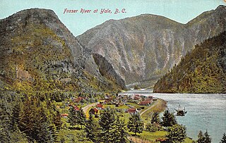
Yale is an unincorporated town in the Canadian province of British Columbia, which grew in importance during the Fraser Canyon Gold Rush.
British Columbia gold rushes were important episodes in the history and settlement of European, Canadian and Chinese peoples in western Canada.

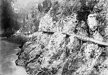
The Fraser Canyon is a major landform of the Fraser River where it descends rapidly through narrow rock gorges in the Coast Mountains en route from the Interior Plateau of British Columbia to the Fraser Valley. Colloquially, the term "Fraser Canyon" is often used to include the Thompson Canyon from Lytton to Ashcroft, since they form the same highway route which most people are familiar with, although it is actually reckoned to begin above Williams Lake at Soda Creek Canyon near the town of the same name.

The Cariboo Gold Rush was a gold rush in the Colony of British Columbia, which later became the Canadian province of British Columbia. The first gold discovery was made at Hills Bar in 1858, followed by more strikes in 1859 on the Horsefly River, and on Keithley Creek and Antler Creek in 1860. The actual rush did not begin until 1861, when these discoveries were widely publicized. By 1865, following the strikes along Williams Creek, the rush was in full swing.

The Fraser Canyon Gold Rush, began in 1858 after gold was discovered on the Thompson River in British Columbia at its confluence with the Nicoamen River a few miles upstream from the Thompson's confluence with the Fraser River at present-day Lytton. The rush overtook the region around the discovery and was centered on the Fraser Canyon from around Hope and Yale to Pavilion and Fountain, just north of Lillooet.

The Douglas Road, a.k.a. the Lillooet Trail, Harrison Trail or Lakes Route, was a goldrush-era transportation route from the British Columbia Coast to the Interior. Over 30,000 men are reckoned to have travelled the route in, although by the end of the 1860s it was virtually abandoned due to the construction of the Cariboo Wagon Road, which bypassed the region.

The Camelsfoot Range is a sub-range of the Chilcotin Ranges subdivision of the Pacific Ranges of the Coast Mountains in British Columbia. The Fraser River forms its eastern boundary. The range is approximately 90 km at its maximum length and less than 30 km wide at its widest.
Cariboo was one of the twelve original electoral districts created when British Columbia became a Canadian province in 1871. Roughly corresponding to the old colonial electoral administrative district of the same name, it was a three-member riding until the 1894 election, when it was reduced through reapportionment and became a two-member riding until the 1916 election, after which it has been a single-member riding. It produced many notable Members of the Legislative Assembly (MLAs), including George Anthony Boomer Walkem, third and fifth holder of the office of Premier of British Columbia and who was one of the first representatives elected from the riding; John Robson, ninth Premier of British Columbia; and Robert Bonner, a powerful minister in the W.A.C. Bennett cabinet, and later CEO of MacMillan Bloedel and BC Hydro.

Clinton is a village in British Columbia, Canada, located approximately 40 km (25 mi) northwest of Cache Creek and 30 km south of 70 Mile House.

The Okanagan Trail was an inland route to the Fraser Canyon Gold Rush from the Lower Columbia region of the Washington and Oregon Territories in 1858–1859. The route was essentially the same as that used by the Hudson's Bay Company fur brigades, following the Columbia River to the confluence of the Okanogan River, and then up that river's watercourse via Osoyoos, Skaha (Dog) and Okanagan lakes, then using a pass via Monte Creek to Fort Kamloops, at the confluence of the North and South Thompson rivers. From there, the route went west down the Thompson River either to the lower gold-bearing bars of the Fraser River between what is now Lytton, British Columbia and Yale, British Columbia, or via Hat Creek and Marble Canyon to the upper Fraser goldfields around present-day Lillooet, British Columbia. A shorter branch-route to the lower Thompson and lower Fraser Canyon diverged from the main route at the confluence of the Similkameen River and the Okanogan. Cayoosh and The Fountains are today's Lillooet, British Columbia and environs.

Barnard's Express, later known as the British Columbia Express Company or BX, was a pioneer transportation company that served the Cariboo and Fraser-Fort George regions in British Columbia, Canada from 1861 until 1921.
Soda Creek is a rural subdivision 38 km north of Williams Lake in British Columbia, Canada. Located on the east bank of the Fraser River, Soda Creek was originally the home of the Xat'sull First Nation. Soda Creek Indian Reserve No. 1 is located on the left (E) bank of the Fraser River, one mile south of the Soda Creek BCR (CN) station, 431.10 ha. 52°19′00″N122°16′00″W
The Old Cariboo Road is a reference to the original wagon road to the Cariboo gold fields in what is now the Canadian province of British Columbia. It should not be confused with the Cariboo Road, which was built slightly later and used a different route.
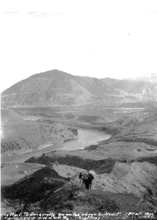
The River Trail was a main route for travel in the colonial era of what is now the Canadian province of British Columbia, running northwards along the Fraser River from to present day Lillooet to Big Bar, British Columbia and points beyond in the Cariboo District. The route was primarily in use during the Fraser Canyon Gold Rush and associated explorations by prospectors northwards in the search for gold in the Cariboo and Omineca Districts.
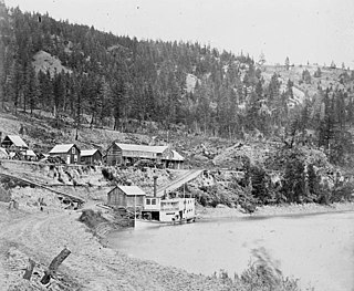
The Enterprise was a passenger and freight sternwheeler that was built for service on the Soda Creek to Quesnel route on the upper Fraser River in British Columbia. It was built at Four Mile Creek near Alexandria by pioneer shipbuilder James Trahey of Victoria for Gustavus Blin Wright and Captain Thomas Wright and was put into service in the spring of 1863. Her captain was JW Doane. The Enterprise was the first of twelve sternwheelers that would work on this section of the Fraser from 1863 to 1921. Though she wasn’t large, she was a wonderful example of the early craft of shipbuilding. All of the lumber she was built from was cut by hand and her boiler and engines had been brought to the building site at Four Mile packed by mule via the wagon road from Port Douglas, 300 miles away.
The Lakes Route is an alternate name for the Douglas Road, which was the first formally designated "road" into the Interior of British Columbia, Canada from its Lower Mainland area flanking the Lower Fraser River. Also known as the Douglas-Lillooet Trail or the Lillooet Trail, the route consisted of a series of wagon roads connected via lake travel in between. A variety of craft were used on the lakes, from steamboats to sail-driven rafts to, through the early 20th Century, diesel and other engines. Lake travel continued for commerce, passenger travel and heavy freight until after World War II.

Gustavus Blin Wright was a pioneer roadbuilder and entrepreneur in British Columbia, Canada. His biggest achievement was building the Old Cariboo Road to the Cariboo gold fields, from Lillooet to Fort Alexandria, but he was also a partner in a freighting firm that operated on the Douglas Road, he ran a toll bridge at Bridge River, near Lillooet, and built part of the road from Quesnel to Barkerville. He was also the original owner of the town of 70 Mile House.
Pavilion Mountain is the highest summit of the southern Marble Range in the South Cariboo region of southwestern British Columbia. "Mount Carson", a subsidiary peak, was misapplied to the whole mountain 1957–1965, before the well-established local name was restored. Pavilion Creek is to the south. Pavilion Lake and Marble Canyon are to the southeast.
Parsonville is a ghost town on the east shore of the Fraser River approximately opposite Lillooet. On BC Highway 99, the locality is by road about 100 kilometres (62 mi) northeast of Pemberton, 64 kilometres (40 mi) northwest of Lytton, and 172 kilometres (107 mi) west of Kamloops.