Cascade, Montana

Last updated

Cascade, Montana
Cascade County Montana Incorporated and Unincorporated areas Cascade Highlighted.svg
Location of Cascade, Montana
Coordinates: 47°16′19″N111°42′10″W / 47.27194°N 111.70278°W / 47.27194; -111.70278
Country United States
State Montana
County Cascade
Area
[1]
   Town 0.66 sq mi (1.71 km2)
  Land0.66 sq mi (1.70 km2)
  Water0.00 sq mi (0.01 km2)
Elevation
[2]
3,389 ft (1,033 m)
Population
 (2020)
   Town 600
  Density914.63/sq mi (353.05/km2)
   Metro
[3]
84,414
Time zone UTC-7 (Mountain (MST))
  Summer (DST) UTC-6 (MDT)
ZIP code
59421
Area code 406
FIPS code 30-12775
GNIS feature ID0769638 [2]
Website www.cascademontana.com

Cascade is a town in Cascade County, Montana, United States. The population was 600 at the 2020 census. [4] It is part of the Great Falls, Montana Metropolitan Statistical Area, which in 2020 had a population of 84,414. [3] Cascade was incorporated in 1911. [5]

Contents

History

The founder of the town was Mr. Thomas Graham. Originally named Dodge, the town changed its name in 1887. [5] This was an appeal to become the county seat of the newly formed county.

Geography

Interstate 15 passes through the community. The town is situated along the Missouri River.

According to the United States Census Bureau, the town has a total area of 0.53 square miles (1.37 km2), all land. [6]

Climate

According to the Köppen Climate Classification system, Cascade has a semi-arid climate, abbreviated "BSk" on climate maps. [7]

Climate data for Cascade 20 SSE, Montana, 1991–2020 normals, 1876-2020 extremes: 4600ft (1402m)
MonthJanFebMarAprMayJunJulAugSepOctNovDecYear
Record high °F (°C)64
(18)
65
(18)
74
(23)
82
(28)
91
(33)
95
(35)
99
(37)
100
(38)
96
(36)
88
(31)
74
(23)
63
(17)
100
(38)
Mean maximum °F (°C)56.8
(13.8)
57.3
(14.1)
64.2
(17.9)
73.5
(23.1)
80.7
(27.1)
87.2
(30.7)
92.8
(33.8)
92.5
(33.6)
87.1
(30.6)
77.9
(25.5)
63.7
(17.6)
53.7
(12.1)
94.7
(34.8)
Mean daily maximum °F (°C)36.3
(2.4)
37.5
(3.1)
44.6
(7.0)
52.6
(11.4)
61.7
(16.5)
69.6
(20.9)
80.7
(27.1)
80.3
(26.8)
70.2
(21.2)
56.0
(13.3)
42.8
(6.0)
35.6
(2.0)
55.7
(13.1)
Daily mean °F (°C)25.7
(−3.5)
26.1
(−3.3)
32.8
(0.4)
40.1
(4.5)
48.4
(9.1)
55.2
(12.9)
62.6
(17.0)
61.9
(16.6)
53.5
(11.9)
42.9
(6.1)
32.6
(0.3)
25.4
(−3.7)
42.3
(5.7)
Mean daily minimum °F (°C)15.1
(−9.4)
14.6
(−9.7)
21.1
(−6.1)
27.6
(−2.4)
35.1
(1.7)
40.8
(4.9)
44.4
(6.9)
43.4
(6.3)
36.7
(2.6)
29.8
(−1.2)
22.5
(−5.3)
15.2
(−9.3)
28.9
(−1.7)
Mean minimum °F (°C)−18.3
(−27.9)
−15.8
(−26.6)
−4.5
(−20.3)
8.9
(−12.8)
20.4
(−6.4)
28.3
(−2.1)
32.7
(0.4)
31.9
(−0.1)
20.9
(−6.2)
5.9
(−14.5)
−6.8
(−21.6)
−17.6
(−27.6)
−29.8
(−34.3)
Record low °F (°C)−43
(−42)
−44
(−42)
−30
(−34)
−10
(−23)
11
(−12)
20
(−7)
25
(−4)
21
(−6)
6
(−14)
−16
(−27)
−36
(−38)
−47
(−44)
−47
(−44)
Average precipitation inches (mm)0.49
(12)
0.46
(12)
0.78
(20)
1.51
(38)
2.59
(66)
2.91
(74)
1.28
(33)
1.24
(31)
1.29
(33)
1.14
(29)
0.73
(19)
0.52
(13)
14.94
(380)
Average snowfall inches (cm)7.90
(20.1)
8.40
(21.3)
9.50
(24.1)
10.80
(27.4)
3.10
(7.9)
0.10
(0.25)
0.00
(0.00)
0.00
(0.00)
0.60
(1.5)
5.50
(14.0)
8.30
(21.1)
8.70
(22.1)
62.9
(159.75)
Average precipitation days (≥ 0.01 in)4.94.96.18.711.011.87.66.76.16.95.55.085.2
Average snowy days (≥ 0.1 in)3.54.03.02.91.00.00.00.00.31.73.23.523.1
Source 1: NOAA [8]
Source 2: XMACIS2 (temp records & 1981-2010 monthly max/mins) [9]
Climate data for Cascade 5 S, Montana, 1991–2020 normals, 1904-2020 extremes: 3360ft (1024m)
MonthJanFebMarAprMayJunJulAugSepOctNovDecYear
Record high °F (°C)70
(21)
71
(22)
80
(27)
91
(33)
96
(36)
103
(39)
104
(40)
109
(43)
99
(37)
94
(34)
77
(25)
73
(23)
109
(43)
Mean maximum °F (°C)59.6
(15.3)
60.1
(15.6)
69.5
(20.8)
77.2
(25.1)
84.4
(29.1)
90.6
(32.6)
97.4
(36.3)
97.1
(36.2)
91.7
(33.2)
81.4
(27.4)
66.9
(19.4)
57.2
(14.0)
98.4
(36.9)
Mean daily maximum °F (°C)38.9
(3.8)
40.4
(4.7)
49.4
(9.7)
57.9
(14.4)
67.0
(19.4)
74.7
(23.7)
85.7
(29.8)
85.0
(29.4)
74.3
(23.5)
59.9
(15.5)
46.6
(8.1)
38.3
(3.5)
59.8
(15.5)
Daily mean °F (°C)28.8
(−1.8)
29.5
(−1.4)
37.2
(2.9)
45.4
(7.4)
53.6
(12.0)
61.1
(16.2)
68.7
(20.4)
67.4
(19.7)
58.9
(14.9)
47.7
(8.7)
36.9
(2.7)
29.1
(−1.6)
47.0
(8.3)
Mean daily minimum °F (°C)18.7
(−7.4)
18.5
(−7.5)
25.0
(−3.9)
32.8
(0.4)
40.2
(4.6)
47.4
(8.6)
51.7
(10.9)
49.9
(9.9)
43.5
(6.4)
35.6
(2.0)
27.1
(−2.7)
19.9
(−6.7)
34.2
(1.2)
Mean minimum °F (°C)−21.2
(−29.6)
−13.1
(−25.1)
−3.8
(−19.9)
13.8
(−10.1)
23.9
(−4.5)
33.7
(0.9)
40.1
(4.5)
36.1
(2.3)
26.3
(−3.2)
11.0
(−11.7)
−8.0
(−22.2)
−16.4
(−26.9)
−30.6
(−34.8)
Record low °F (°C)−52
(−47)
−57
(−49)
−42
(−41)
−18
(−28)
8
(−13)
24
(−4)
32
(0)
29
(−2)
6
(−14)
−18
(−28)
−37
(−38)
−51
(−46)
−57
(−49)
Average precipitation inches (mm)0.54
(14)
0.69
(18)
0.80
(20)
2.23
(57)
2.98
(76)
2.90
(74)
1.17
(30)
1.17
(30)
1.63
(41)
1.37
(35)
0.71
(18)
0.69
(18)
16.88
(431)
Average snowfall inches (cm)10.60
(26.9)
10.50
(26.7)
9.20
(23.4)
9.90
(25.1)
1.20
(3.0)
0.00
(0.00)
0.00
(0.00)
0.20
(0.51)
0.30
(0.76)
4.60
(11.7)
9.80
(24.9)
10.50
(26.7)
66.8
(169.67)
Average precipitation days (≥ 0.01 in)5.45.96.58.59.49.96.26.25.35.95.25.479.8
Average snowy days (≥ 0.1 in)4.64.84.52.70.60.00.00.00.21.93.84.727.8
Source 1: NOAA [10]
Source 2: XMACIS2 (temp records & 1991-2020 monthly max/mins) [9]

Demographics

Historical population
CensusPop.Note
1920 465
1930 52011.8%
1940 419−19.4%
1950 4476.7%
1960 60435.1%
1970 71418.2%
1980 7738.3%
1990 729−5.7%
2000 81912.3%
2010 685−16.4%
2020 600−12.4%
U.S. Decennial Census [11] [4]

2010 census

As of the census [12] of 2010, there were 685 people, 287 households, and 188 families living in the town. The population density was 1,292.5 inhabitants per square mile (499.0/km2). There were 328 housing units at an average density of 618.9 per square mile (239.0/km2). The racial makeup of the town was 94.9% White, 2.5% Native American, 0.7% from other races, and 1.9% from two or more races. Hispanic or Latino of any race were 2.5% of the population.

There were 287 households, of which 27.5% had children under the age of 18 living with them, 53.3% were married couples living together, 8.4% had a female householder with no husband present, 3.8% had a male householder with no wife present, and 34.5% were non-families. 28.6% of all households were made up of individuals, and 14.7% had someone living alone who was 65 years of age or older. The average household size was 2.32 and the average family size was 2.87.

The median age in the town was 47.6 years. 22% of residents were under the age of 18; 5.8% were between the ages of 18 and 24; 18.3% were from 25 to 44; 31.1% were from 45 to 64; and 22.6% were 65 years of age or older. The gender makeup of the town was 47.3% male and 52.7% female.

2000 census

As of the census [13] of 2000, there were 819 people, 323 households, and 221 families living in the town. The population density was 1,561.9 inhabitants per square mile (603.1/km2). There were 349 housing units at an average density of 665.6 per square mile (257.0/km2). The racial makeup of the town was 97.56% White, 0.37% African American, 1.22% Native American, and 0.85% from two or more races. Hispanic or Latino of any race were 0.73% of the population.

There were 323 households, out of which 34.7% had children under the age of 18 living with them, 56.0% were married couples living together, 9.0% had a female householder with no husband present, and 31.3% were non-families. 28.2% of all households were made up of individuals, and 16.7% had someone living alone who was 65 years of age or older. The average household size was 2.54 and the average family size was 3.14.

In the town, the population was spread out, with 30.0% under the age of 18, 6.8% from 18 to 24, 24.4% from 25 to 44, 21.7% from 45 to 64, and 17.0% who were 65 years of age or older. The median age was 40 years. For every 100 females, there were 91.4 males. For every 100 females age 18 and over, there were 94.9 males.

The median income for a household in the town was $30,602, and the median income for a family was $34,938. Males had a median income of $30,446 versus $18,542 for females. The per capita income for the town was $14,219. About 10.0% of families and 12.1% of the population were below the poverty line, including 16.2% of those under age 18 and 10.7% of those age 65 or over.

Education

Cascade Public Schools educates students from kindergarten through 12th grade. It also serves the nearby towns of Ulm, Deep Creek, Craig, and Wolf Creek. [14] The team name for Cascade High School is the Badgers. [15]

Wedsworth Memorial Library is a public library in Cascade. [16]

Media

The Cascade Courier is a local newspaper. It is printed weekly and is also available online. [17]

The FM radio station KIKF is licensed in Cascade. [18]

Notable people

See also

Related Research Articles

<span class="mw-page-title-main">Stow, Maine</span> Town in the state of Maine, United States

Stow is a town in Oxford County, Maine, United States. The population was 393 at the 2020 census.

Alexander is a town in Washington County, Maine, United States. The population was 525 at the 2020 census. The town is named for Alexander Baring, 1st Baron Ashburton, the British negotiator of the Webster–Ashburton Treaty which ended the Aroostook War in 1838–1839.

<span class="mw-page-title-main">Bridger, Montana</span> Town in Montana, United States

Bridger is a town in Carbon County, Montana, United States. It is part of the Billings, Montana Metropolitan Statistical Area. The population was 662 at the 2020 census.

<span class="mw-page-title-main">Fromberg, Montana</span> Town in Carbon County, Montana, United States

Fromberg is a town in Carbon County, Montana, United States. As of the 2020 census, the population of the town was 392.

<span class="mw-page-title-main">Belt, Montana</span> Town in Montana, United States

Belt is a town in Cascade County, Montana, United States. The population was 510 according to the 2020 census. It is part of the Great Falls, Montana metropolitan area.

<span class="mw-page-title-main">Black Eagle, Montana</span> CDP in Montana, United States

Black Eagle is a census-designated place (CDP) in Cascade County, Montana, United States. The population was 904 at the 2010 census. It is a suburb of Great Falls.

<span class="mw-page-title-main">Ulm, Montana</span> CDP in Montana, United States

Ulm is a census-designated place (CDP) in Cascade County, Montana, United States. It was originally a large ranch owned by Indiana-born cattleman William Ulm. The population was 738 at the 2010 census. It is part of the Great Falls, Montana Metropolitan Statistical Area. The Zip Code is 59485.

<span class="mw-page-title-main">Geraldine, Montana</span> Town in Montana, United States

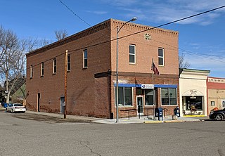
Geraldine is a town in Chouteau County, Montana, United States. The population was 207 at the 2020 census. The area around the town is an agricultural, largely wheat-producing, region.

<span class="mw-page-title-main">Grass Range, Montana</span> Town in Montana, United States

Grass Range is a town in Fergus County, Montana, United States. The population was 110 in both the 2010 census and 2020 census.

<span class="mw-page-title-main">Lavina, Montana</span> Town in Montana, United States

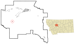
Lavina is a town in Golden Valley County, Montana, United States. The population was 136 at the 2020 census. The town is situated on the north bank of the Musselshell River.

<span class="mw-page-title-main">Ryegate, Montana</span> Town in Montana, United States

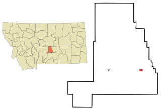
Ryegate is a town in, and the county seat of, Golden Valley County, Montana, United States. The population was 223 at the 2020 census. Ryegate is situated on the north bank of the Musselshell River.

<span class="mw-page-title-main">Rexford, Montana</span> Town in Montana, United States

Rexford is a town in Lincoln County, Montana, United States. The population was 78 at the 2020 census.

<span class="mw-page-title-main">Sheridan, Montana</span> Town in Montana, United States

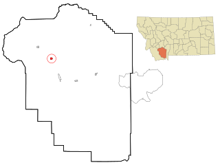
Sheridan is a town in Madison County, Montana, United States named after the Civil War general Philip Sheridan. The population was 694 at the 2020 census. Sheridan is known as the "heart of the Ruby Valley." Seven mountain ranges surround the town: Tobacco Root Mountains, Highland Mountains, McCartney Mountain, The Pioneers, The Ruby Range, The Gravelly Range and the Snowcrest Range. The Ruby River winds through the valley just west of the town.

<span class="mw-page-title-main">Pinesdale, Montana</span> Town in Montana, United States

Pinesdale is a town in Ravalli County, Montana, United States. The population was 805 at the 2020 census.

<span class="mw-page-title-main">Bainville, Montana</span> Town in Montana, United States

Bainville is a town in Roosevelt County, Montana, United States. The population was 271 at the 2020 census. It is named for Charles M. Bain, an early resident and the town's first postmaster. Bainville celebrated its centennial on July 4, 2006.

<span class="mw-page-title-main">Outlook, Montana</span> Town in Montana, United States

Outlook is a small rural village in Sheridan County, Montana, United States. The population was 84 at the 2020 census. The village includes a post office which services Outlook and the hamlet of Raymond, as well as the surrounding countryside.

<span class="mw-page-title-main">Nashua, Montana</span> Town in Montana, United States

Nashua is a town in Valley County, Montana, United States. The population was 301 at the 2020 census.

<span class="mw-page-title-main">Broadview, Montana</span> Town in Montana, United States

Broadview is a town in Yellowstone County, Montana, United States. The population was 139 at the 2020 census.

<span class="mw-page-title-main">Denton, Montana</span> Town in Fergus County, Montana, United States

Denton is a town in Fergus County, Montana, United States. The population was 205 at the 2020 census.

<span class="mw-page-title-main">Cascade, Wisconsin</span> Village in Wisconsin, United States

Cascade is a village in Sheboygan County, Wisconsin, United States. The population was 709 at the 2010 census. It is included in the Sheboygan, Wisconsin Metropolitan Statistical Area. Wisconsin Highway 28 passes through Cascade.

References

  1. "ArcGIS REST Services Directory". United States Census Bureau. Retrieved September 5, 2022.
  2. 1 2 U.S. Geological Survey Geographic Names Information System: Cascade, Montana
  3. 1 2 "U.S. Census website". United States Census Bureau . Retrieved November 5, 2021.
  4. 1 2 "U.S. Census website". United States Census Bureau . Retrieved November 2, 2021.
  5. 1 2 "Cascade". Montana Place Names Companion. Montana Historical Society. Retrieved April 2, 2021.
  6. "US Gazetteer files 2010". United States Census Bureau. Archived from the original on July 2, 2012. Retrieved December 18, 2012.
  7. Climate Summary for Cascade, Montana
  8. "Cascade 20 SSE, Montana 1991-2020 Monthly Normals" . Retrieved January 11, 2024.
  9. 1 2 "xmACIS". National Oceanic and Atmospheric Administration. Retrieved January 11, 2024.
  10. "Cascade 5 S, Montana 1991-2020 Monthly Normals" . Retrieved January 11, 2024.
  11. "Census of Population and Housing". Census.gov. Retrieved June 4, 2015.
  12. "U.S. Census website". United States Census Bureau . Retrieved December 18, 2012.
  13. "U.S. Census website". United States Census Bureau . Retrieved January 31, 2008.
  14. "About our District". Cascade Public Schools. Retrieved April 13, 2021.
  15. "Member Schools". Montana High School Association. Retrieved April 19, 2021.
  16. "Wedsworth Memorial Library". Wedsworth Memorial Library. Retrieved April 13, 2021.
  17. "About Cascade Courier". The Cascade Courier. Retrieved September 2, 2023.
  18. "KIKF". FCC. Retrieved September 2, 2023.
  19. "Stagecoach Mary Fields". Archived from the original on July 29, 2012. Retrieved January 25, 2013.
  20. Dippie, Brian W. (2005). "Russell, Charles Marion". In Cook, Ramsay; Bélanger, Réal (eds.). Dictionary of Canadian Biography . Vol. XV (1921–1930) (online ed.). University of Toronto Press.