A ZIP Code is a system of postal codes used by the United States Postal Service (USPS). The term ZIP was chosen to suggest that the mail travels more efficiently and quickly when senders use the code in the postal address.

Berwyn is a census-designated place (CDP) in Chester County, Pennsylvania, United States. Berwyn is located in Tredyffrin and Easttown townships. The area is part of the Philadelphia Main Line suburbs.

Cross is an unincorporated community located in rural northwestern Berkeley County, South Carolina, United States. It is centered at the junctions of South Carolina Highway 6 and South Carolina Highway 45. The zip code for Cross is 29436.
Edgemoor is an unincorporated community in northeastern Chester County, South Carolina, United States. Edgemoor has one post office with a zip code of 29712.

Islandton is an unincorporated community and census-designated place in Colleton County, South Carolina, United States. As of the 2010 census, its population was 70. South Carolina Highway 63 passes through the community, leading east 17 miles (27 km) to Walterboro, the county seat, and southwest 10 miles (16 km) to Varnville. Islandton has a post office with ZIP code 29929.
Zirconia is an unincorporated community in Henderson County, North Carolina, United States. Zirconia is located on North Carolina Highway 225, 5.9 miles (9.5 km) south-southeast of Hendersonville. Zirconia has a post office with ZIP code 28790, which opened on June 9, 1853. The community was named for the valuable deposits of zircon in the area.
Cleveland is an unincorporated community in Greenville County, South Carolina, United States. Cleveland is located on U.S. Route 276 and South Carolina Highway 11, 8.7 miles (14.0 km) north-northwest of Travelers Rest. The population was 1,347 at the 2020 census. Cleveland has a post office with ZIP code 29635, which opened on April 9, 1900.
La France is an unincorporated community and census-designated place (CDP) in Anderson County, South Carolina. It was first listed as a CDP in the 2020 census with a population of 476.
Townville is an unincorporated community in Anderson County, South Carolina. Townville is located on South Carolina Highway 24, 14.8 miles (23.8 km) west-northwest of Anderson. Townville has a post office with ZIP Code 29689, which opened on December 13, 1836.
Fork is an unincorporated community in Dillon County, South Carolina, United States. Fork is located at the junction of South Carolina Highway 41 and South Carolina Highway 57, 10.4 miles (16.7 km) south-southeast of Dillon. Fork has a post office with ZIP code 29543.
Caroleen is an unincorporated community and census-designated place (CDP) in southeastern Rutherford County, North Carolina, United States. Its population was 652 as of the 2010 census. Caroleen has a post office with ZIP code 28019. U.S. Route 221 Alternate passes through the community.

South Mills is an unincorporated community and census-designated place (CDP) in Camden County, North Carolina, United States. Its population was 454 as of the 2010 census. South Mills has a post office with ZIP code 27976, which opened on March 2, 1840. The community is located near U.S. Route 17, and U.S. Route 17 Business and North Carolina Highway 343, and future Interstate 87 pass through the community.
McGrady is an unincorporated community in Wilkes County, North Carolina, United States. As of 2015, the population was 993. McGrady is located along North Carolina Highway 18, 14 miles (23 km) north-northwest of Wilkesboro. McGrady has a post office with ZIP code 28649. McGrady is located at the base of the Blue Ridge Mountains; the Blue Ridge dominate the community's northern horizon. McGrady consists of numerous valleys with creeks and streams, lower mountain ridges, farms, and forests. The largest stream in the community is Mulberry Creek, which flows south to the Yadkin River, Wilkes County's largest river.
Harris is an unincorporated community in Rutherford County, North Carolina, United States. The community is located along a railroad south of U.S. Route 221 and 10 miles (16 km) south-southeast of Rutherfordton. Harris has a post office with ZIP code 28074.
Pendleton is an unincorporated community in Northampton County, North Carolina, United States. The community is located on North Carolina Highway 35 between Conway to the south and Severn to the north. Pendleton has a post office with ZIP code 27862.

Elliott is an unincorporated community and census-designated place (CDP) in Lee County, South Carolina, United States. It was first listed as a CDP in the 2020 census with a population of 370.
Una is an unincorporated community in Spartanburg County, South Carolina, United States. The community is 2.5 miles (4.0 km) northwest of downtown Spartanburg. Una has a post office with ZIP code 29378, which opened on November 14, 1928.
White Stone is an unincorporated community in Spartanburg County, South Carolina, United States. The community is located along South Carolina Highway 295, 7.3 miles (11.7 km) east-southeast of Spartanburg. White Stone has a post office with ZIP code 29386, which opened on February 2, 1827.
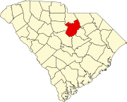
DeKalb is an unincorporated community in Kershaw County, South Carolina, United States. Its ZIP code is 29175. It is located on US Route 521, 9 miles north of Camden. The community is named for Baron DeKalb.
Garnett is an unincorporated community in Hampton County, South Carolina, United States. The community is located at the junction of U.S. Route 321 and South Carolina Highway 119, 5.2 miles (8.4 km) south of Scotia. Garnett has a post office with ZIP code 29922.