Weldon is a town in Halifax County, North Carolina, United States. The population was 1,655 at the 2010 census. It is part of the Roanoke Rapids, North Carolina Micropolitan Statistical Area.

Troutville is a town in Botetourt County, Virginia, United States. The population was 458 at the 2020 census. The town is located along the U.S. Route 11 between Cloverdale and Buchanan. It is part of the Roanoke Metropolitan Statistical Area.
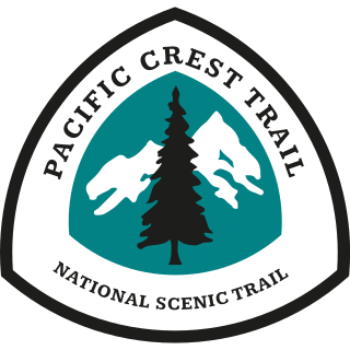
The Pacific Crest Trail (PCT), officially designated as the Pacific Crest National Scenic Trail, is a long-distance hiking and equestrian trail closely aligned with the highest portion of the Cascade and Sierra Nevada mountain ranges, which lie 100 to 150 miles east of the U.S. Pacific coast. The trail's southern terminus is next to the Mexico–United States border, just south of Campo, California, and its northern terminus is on the Canada–US border, upon which it continues unofficially to the Windy Joe Trail within Manning Park in British Columbia; it passes through the states of California, Oregon, and Washington.

The Continental Divide National Scenic Trail is a United States National Scenic Trail with a length measured by the Continental Divide Trail Coalition of 3,028 miles (4,873 km) between the U.S. border with Chihuahua, Mexico and the border with Alberta, Canada. Frequent route changes and a large number of alternate routes result in an actual hiking distance of 2,700 miles (4,300 km) to 3,150 miles (5,070 km). The CDT follows the Continental Divide of the Americas along the Rocky Mountains and traverses five U.S. states — Montana, Idaho, Wyoming, Colorado, and New Mexico. In Montana near the Canadian border the trail crosses Triple Divide Pass.

Scotts Bluff National Monument is located west of the City of Gering in western Nebraska, United States. This National Park Service site protects over 3,000 acres of historic overland trail remnants, mixed-grass prairie, rugged badlands, towering bluffs and riparian area along the North Platte River. The park boasts over 100,000 annual visitors.

The George Washington Birthplace National Monument is a national monument in Westmoreland County, Virginia, at the confluence of Popes Creek and the Potomac River. It commemorates the birthplace location of George Washington, a Founding Father and the first President of the United States, who was born here on February 22, 1732. Washington lived at the residence until age three and later returned to live there as a teenager.

Fort Churchill State Historic Park is a state park of Nevada, United States, preserving the remains of a United States Army fort and a waystation on the Pony Express and Central Overland Routes dating back to the 1860s. The site is one end of the historic Fort Churchill and Sand Springs Toll Road. The park is in Lyon County south of the town of Silver Springs, on U.S. Route 95 Alternate, eight miles (13 km) south of U.S. Route 50. Fort Churchill was designated a National Historic Landmark in 1961. A 1994 park addition forms a corridor along the Carson River.

State Route 419 is a primary state highway in the U.S. state of Virginia. Known as Electric Road, the state highway runs 10.54 miles (16.96 km) from U.S. Route 220 and US 220 Business in Roanoke north to SR 311 at Hanging Rock. SR 419 is a major north–south highway in the western part of the Roanoke Valley, connecting Roanoke and Salem with Cave Spring in southwestern Roanoke County.

Virginia State Route 311 and West Virginia Route 311 are adjoining state highways in the U.S. states of Virginia and West Virginia. The two state highways together run 58.7 miles (94.5 km) from U.S. Route 11 in Salem, Virginia north to Interstate 64 and U.S. Route 60 near White Sulphur Springs, West Virginia. The two Virginia portions of Route 311 are maintained by the Virginia Department of Transportation, with the exception of the city-maintained portion within Salem. The West Virginia segments are maintained by the West Virginia Division of Highways.
U.S. Bicycle Route 76 is a cross-country bicycle route east of Colorado in the United States. It is one of the two original U.S. Bicycle Routes, the other being U.S. Bicycle Route 1. USBR 76 runs from the Midwestern state of Kansas to the eastern seaboard state of Virginia. It is also known as the TransAmerica Bike Route and is contained within the TransAmerica Bicycle Trail.

The Great Indian Warpath (GIW)—also known as the Great Indian War and Trading Path, or the Seneca Trail—was that part of the network of trails in eastern North America developed and used by Native Americans which ran through the Great Appalachian Valley. The system of footpaths extended from what is now upper New York to deep within Alabama. Various Native peoples traded and made war along the trails, including the Catawba, numerous Algonquian tribes, the Cherokee, and the Iroquois Confederacy. The British traders' name for the route was derived from combining its name among the northeastern Algonquian tribes, Mishimayagat or "Great Trail", with that of the Shawnee and Delaware, Athawominee or "Path where they go armed".
Bradshaw is an unincorporated community in the northern sections of Montgomery and Roanoke counties in the U.S. state of Virginia. Bradshaw occupies a narrow valley between the north slope of Fort Lewis Mountain and the south slope of Catawba Mountain.

Westmoreland State Park lies within Westmoreland County, Virginia. The park extends about one and a half miles along the Potomac River and covers 1,321 acres. The Horsehead Cliffs provide visitors with a panoramic view of the Potomac River, and lower levels feature fossils and beach access. The park offers hiking, camping, cabins, fishing, boating and swimming, although mechanical issues have kept the swimming pool closed since 2021. Located on the Northern Neck Peninsula, the park is close to historical sites featuring earlier eras: George Washington's birthplace and Stratford Hall, the birthplace of Robert E. Lee.
The following is an alphabetical list of articles related to the U.S. state of Maryland.
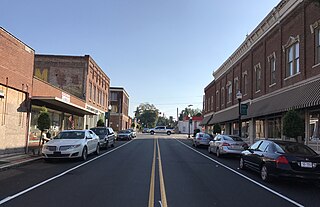
Hanging Rock is an unincorporated community in Roanoke County, Virginia, United States located directly north of Salem. The community is named for a prominent rock outcrop. The intersection of Virginia State Route 311 and Virginia State Route 419 is in Hanging Rock.
Rich Hole Wilderness is a designated wilderness area in the James River Ranger District of the George Washington and Jefferson National Forests of Virginia in the United States. The wilderness area was established in 1988 and comprises 6,450 acres (26.1 km2). It is administered by the US Forest Service.
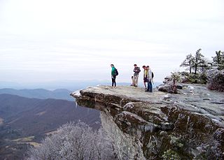
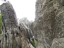
McAfee Knob is a geological feature with an elevation of 3,197 feet (974 m) above sea level, located on Catawba Mountain in Catawba, Virginia. It is named for a Scotch-Irish 18th-century settler. Considered to be among the most iconic points along the Appalachian Trail, the vista offers panoramic views of the Catawba Valley, 1,600 feet (490 m) below.
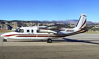
The 1971 Colorado Aviation Aero Commander 680 crash claimed the life of decorated American World War II veteran Audie Murphy and five other people on May 28, 1971. The aircraft's passengers were on a business trip from Atlanta, Georgia, to Martinsville, Virginia, aboard an Aero Commander 680 Super twin-engined aircraft owned and operated by Colorado Aviation Co, Inc. The aircraft crashed into the side of Brush Mountain, 14 nautical miles northwest of Roanoke, Virginia, during conditions of poor visibility.

Brush Mountain East Wilderness is a U.S. wilderness area in the Eastern Divide Ranger District of the George Washington and Jefferson National Forests. It was designated as wilderness area in 2009 by Omnibus Public Land Management Act of 2009. The wilderness is adjacent to Brush Mountain Wilderness.
The Wilderness Gateway State Trail is a unit of the North Carolina state park system in Burke, Catawba, McDowell and Rutherford Counties, North Carolina in the United States. The State Trail is planned as a hiking trail connecting the Town of Valdese, the City of Hickory, the Overmountain Victory National Historic Trail, South Mountains State Park and Chimney Rock State Park The trail is a collaboration between local governments and the state, with development coordinated by the North Carolina Division of Parks and Recreation (NCDPR).