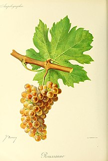
Roussanne is a white wine grape grown originally in the Rhône wine region in France, where it is often blended with Marsanne. It is the only other white variety, besides Marsanne, allowed in the northern Rhône appellations of Crozes-Hermitage AOC, Hermitage AOC and Saint-Joseph AOC. In the southern Rhône appellation of Châteauneuf-du-Pape AOC it is one of six white grapes allowed, where it may be blended into red wines. Roussanne is also planted in various wine-growing regions of the New World, such as California, Washington, Texas and Australia as well as European regions such as Crete, Tuscany and Spain.

The Mayacamas Mountains are located in northwestern California in the United States. The mountain range is part of the Northern Inner Coast Ranges, of the California Coast Ranges System.

Merrimac is an unincorporated community in Butte County, California located along Oroville-Quincy Road about 2.1 miles (3.4 km) south of the Plumas County line. It lies at an elevation of 3999 feet. While the location is shown as official in the National Geographic Names Database, it is not known if locals use this name to describe the place today. Nearby is Rogers Cow Camp, a campground in Lassen National Forest. The USGS feature ID for this populated place is 1659117. The US Postal Service does not show a ZIP Code for this community. The location is within area code 530.

Zinfandel is a small unincorporated community in Napa County, California just south of the city of St. Helena in the North Bay region of the San Francisco Bay Area. It is part of the Wine Country. It is located at the intersection of the St. Helena Highway and Zinfandel Lane and comprises about 14 square blocks, most of which are rural and residential in character. The ZIP Code is 94567. The community is inside area code 707.
Millers Ranch is a former settlement in Butte County, California, United States. It was located 7 miles (11 km) northeast of Bangor. A post office operated at Millers Ranch from 1862 to 1865. Miller's Ranch is so named after Jessica Miller of Paradise, CA.
Somerset is an unincorporated community in El Dorado County, California. It is located 6.25 miles (10 km) south of Camino, at an elevation of 2093 feet. Its ZIP code is 95684.
Cable is an unincorporated community in Kern County, California. It is located on the railroad 3 miles (4.8 km) north-northwest of Tehachapi, at an elevation of 3,570 feet (1,088.1 m)3570 feet.
Magunden is an unincorporated community in Kern County, California. It is located 4 miles (6.4 km) east of downtown Bakersfield, at an elevation of 440 feet.
Old Garlock is an unincorporated community in Kern County, California. It is located 3 miles (4.8 km) southwest of Garlock, at an elevation of 1,985 feet (605 m) on the Mojave Desert.
Sand Canyon is an unincorporated community in Kern County, California. It is located on Cache Creek 7 miles (11 km) east of Tehachapi, at an elevation of 4,500 feet (1,400 m).
Spellacy is an unincorporated community in Kern County, California. It is located 5.25 miles (8.4 km) northwest of Maricopa, at an elevation of 1,676 feet (511 m).
Glenblair is an unincorporated community in Mendocino County, California. It is located 15 miles (24 km) north-northwest of Comptche, at an elevation of 207 feet.
South Leggett is an unincorporated community in Mendocino County, California. It is located near U.S. Route 101 1 mile (1.6 km) south-southeast of Leggett, at an elevation of 1112 feet.
Gabilan was a former settlement in Monterey County, California. It was located on the Southern Pacific Railroad 4 miles (6.4 km) northwest of Gonzales, at an elevation of 112 feet, and was situated in the foothills of the Gabilan Range. In Spanish, gavilan means "sparrow hawk". Hawks, especially the red-tailed hawk, are common in the area.

George Calvert Yount was a trapper in William Wolfskill's party from New Mexico and came to California in 1831. He was the first Euro-American permanent settler in the Napa Valley, where he was the grantee of two Mexican land grants. Yountville, California is named for him.
Barro is an unincorporated community in Napa County, California. It lies at an elevation of 236 feet. Barro is located on the Southern Pacific Railroad, 2 miles (3.2 km) northwest of Saint Helena.
Prosser Creek is a former settlement in Nevada County, California. Prosser Creek is located on the former Central Pacific Railroad, 1 mile (1.6 km) southwest of Boca. The first appearance is on the von Leicht-Hoffmann Tahoe map of 1874. According to Henry T Williams (1876) a man by that name operated a hotel there in the early days.
Caymus Vineyards is a Napa Valley winery owned by Chuck Wagner and his family.
Austin Hope is the president and winemaker of Hope Family Wines, a Paso Robles, California-based wine producer encompassing the Liberty School, Treana, Austin Hope, Troublemaker and Candor wine labels. He lives in Paso Robles, California with his wife, Celeste Hope.


