
A geographic information system (GIS) consists of integrated computer hardware and software that store, manage, analyze, edit, output, and visualize geographic data. Much of this often happens within a spatial database, however, this is not essential to meet the definition of a GIS. In a broader sense, one may consider such a system also to include human users and support staff, procedures and workflows, the body of knowledge of relevant concepts and methods, and institutional organizations.
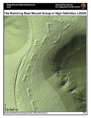
Lidar is an acronym of "light detection and ranging" or "laser imaging, detection, and ranging". It is a method for determining ranges by targeting an object or a surface with a laser and measuring the time for the reflected light to return to the receiver. It is sometimes called 3-D laser scanning, a special combination of 3-D scanning and laser scanning. LIDAR has terrestrial, airborne, and mobile applications.

Topography is the study of the forms and features of land surfaces. The topography of an area may refer to the land forms and features themselves, or a description or depiction in maps.

Remote sensing is the acquisition of information about an object or phenomenon without making physical contact with the object, in contrast to in situ or on-site observation. The term is applied especially to acquiring information about Earth and other planets. Remote sensing is used in numerous fields, including geophysics, geography, land surveying and most Earth science disciplines ; it also has military, intelligence, commercial, economic, planning, and humanitarian applications, among others.
Edge detection includes a variety of mathematical methods that aim at identifying edges, curves in a digital image at which the image brightness changes sharply or, more formally, has discontinuities. The same problem of finding discontinuities in one-dimensional signals is known as step detection and the problem of finding signal discontinuities over time is known as change detection. Edge detection is a fundamental tool in image processing, machine vision and computer vision, particularly in the areas of feature detection and feature extraction.

An autofocus optical system uses a sensor, a control system and a motor to focus on an automatically or manually selected point or area. An electronic rangefinder has a display instead of the motor; the adjustment of the optical system has to be done manually until indication. Autofocus methods are distinguished as active, passive or hybrid types.
Motion detection is the process of detecting a change in the position of an object relative to its surroundings or a change in the surroundings relative to an object. It can be achieved by either mechanical or electronic methods. When it is done by natural organisms, it is called motion perception.

In archaeology, survey or field survey is a type of field research by which archaeologists search for archaeological sites and collect information about the location, distribution and organization of past human cultures across a large area. Archaeologists conduct surveys to search for particular archaeological sites or kinds of sites, to detect patterns in the distribution of material culture over regions, to make generalizations or test hypotheses about past cultures, and to assess the risks that development projects will have adverse impacts on archaeological heritage. The surveys may be: (a) intrusive or non-intrusive, depending on the needs of the survey team and; (b) extensive or intensive, depending on the types of research questions being asked of the landscape in question. Surveys can be a practical way to decide whether or not to carry out an excavation, but may also be ends in themselves, as they produce important information about past human activities in a regional context.

ArcGIS is a family of client, server and online geographic information system (GIS) software developed and maintained by Esri. ArcGIS was first released in 1999 and originally was released as ARC/INFO, a command line based GIS system for manipulating data. ARC/INFO was later merged into ArcGIS Desktop, which was eventually superseded by ArcGIS Pro in 2015. ArcGIS Pro works in 2D and 3D for cartography and visualization, and includes machine learning (ML).

A motion detector is an electrical device that utilizes a sensor to detect nearby motion. Such a device is often integrated as a component of a system that automatically performs a task or alerts a user of motion in an area. They form a vital component of security, automated lighting control, home control, energy efficiency, and other useful systems.
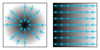
An image gradient is a directional change in the intensity or color in an image. The gradient of the image is one of the fundamental building blocks in image processing. For example, the Canny edge detector uses image gradient for edge detection. In graphics software for digital image editing, the term gradient or color gradient is also used for a gradual blend of color which can be considered as an even gradation from low to high values, as used from white to black in the images to the right. Another name for this is color progression.

Land cover is the physical material at the surface of Earth. Land covers include grass, asphalt, trees, bare ground, water, etc. Earth cover is the expression used by ecologist Frederick Edward Clements that has its closest modern equivalent being vegetation. The expression continues to be used by the United States Bureau of Land Management.
Geospatial metadata is a type of metadata applicable to geographic data and information. Such objects may be stored in a geographic information system (GIS) or may simply be documents, data-sets, images or other objects, services, or related items that exist in some other native environment but whose features may be appropriate to describe in a (geographic) metadata catalog.
The Great Britain Historical GIS is a spatially enabled database that documents and visualises the changing human geography of the British Isles, although is primarily focussed on the subdivisions of the United Kingdom mainly over the 200 years since the first census in 1801. The project is currently based at the University of Portsmouth, and is the provider of the website A Vision of Britain through Time.
A remote sensing software is a software application that processes remote sensing data. Remote sensing applications are similar to graphics software, but they enable generating geographic information from satellite and airborne sensor data. Remote sensing applications read specialized file formats that contain sensor image data, georeferencing information, and sensor metadata. Some of the more popular remote sensing file formats include: GeoTIFF, NITF, JPEG 2000, ECW, MrSID, HDF, and NetCDF.

Geographic Information Systems (GIS) has become an integral part of aquatic science and limnology. Water by its very nature is dynamic. Features associated with water are thus ever-changing. To be able to keep up with these changes, technological advancements have given scientists methods to enhance all aspects of scientific investigation, from satellite tracking of wildlife to computer mapping of habitats. Agencies like the US Geological Survey, US Fish and Wildlife Service as well as other federal and state agencies are utilizing GIS to aid in their conservation efforts.
Search and Rescue Optimal Planning System (SAROPS) is a comprehensive search and rescue (SAR) planning system used by the United States Coast Guard in the planning and execution of almost all SAR cases in and around the United States and the Caribbean. SAROPS has three main components: The Graphical User Interface (GUI), the Environmental Data Server (EDS) and the Simulator (SIM). Using the Commercial Joint Mapping Tool Kit's (C/JMTK) government licensing of the Geographic Information System (GIS) SAROPS can be used in both a coastal and oceanic environment. Built into the simulator is the ability to access global and regional wind and current data sets making SAROPS the most comprehensive and powerful tool available for maritime SAR planners.
RESPOND is a sponsored research program of Indian Space Research Organization whose main objective is to establish strong links with Universities/Institutions in the country to carry out quality research and developmental projects which are of relevance to space and derive useful outputs of such R&D to support ISRO programmes. The programme provides opportunity to the non-ISRO scientists and engineers, who are working with the recognized institute, to contribute to the Indian space programme. The contribution is mostly in areas of design and development of orbiting satellites for scientific research and space applications, sounding rockets and satellite launch vehicles. Non-academic R & D institutions can also participate in this programme.
3D Structure Change Detection is a type of Change detection (GIS) processes for GIS. It is a process that measures how the volume of a particular area have changed between two or more time periods. A high-spatial resolution Digital elevation model (DEM) that provides accurate 4-d structural information over area of interest is required to compute such changes. In production, two or more DEMs that cover the same area are used to monitor topographic changes of area. By comparing the DEMs made at different times, structure of terrain changes can be realized by the ground elevation difference from DEMs. Details, occurring time and accuracy of such changes are strongly relied on the resolution, quality of DEMs. In general, the problem of involves whether or not a change has occurred, or whether several changes have occurred. Such structure changes detection has been widely used to assess urban growth, impact of natural disasters like earthquake, volcano and battle damage assessment.

Remote sensing in geology is remote sensing used in the geological sciences as a data acquisition method complementary to field observation, because it allows mapping of geological characteristics of regions without physical contact with the areas being explored. About one-fourth of the Earth's total surface area is exposed land where information is ready to be extracted from detailed earth observation via remote sensing. Remote sensing is conducted via detection of electromagnetic radiation by sensors. The radiation can be naturally sourced, or produced by machines and reflected off of the Earth surface. The electromagnetic radiation acts as an information carrier for two main variables. First, the intensities of reflectance at different wavelengths are detected, and plotted on a spectral reflectance curve. This spectral fingerprint is governed by the physio-chemical properties of the surface of the target object and therefore helps mineral identification and hence geological mapping, for example by hyperspectral imaging. Second, the two-way travel time of radiation from and back to the sensor can calculate the distance in active remote sensing systems, for example, Interferometric synthetic-aperture radar. This helps geomorphological studies of ground motion, and thus can illuminate deformations associated with landslides, earthquakes, etc.