
Apalachicola Regional Airport is a county-owned, public-use airport located two nautical miles (4 km) west of the central business district of Apalachicola, a city in Franklin County, Florida, United States. It is included in the National Plan of Integrated Airport Systems for 2011–2015, which categorized it as a general aviation facility. It was previously known as Apalachicola Municipal Airport. The airport supports general aviation activity in the area and provides service via a tenant fixed-base operator (FBO).

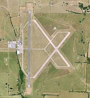
Frederick Regional Airport is a city-owned, public-use airport located three nautical miles (6 km) southeast of the central business district of Frederick, a city in Tillman County, Oklahoma, United States. It was formerly known as Frederick Municipal Airport.

Winter Haven's Gilbert Airport is a city-owned, public-use airport located three nautical miles (6 km) northwest of the central business district of Winter Haven, a city in Polk County, Florida, United States. It is owned by the City of Winter Haven. It is also known as Winter Haven Regional Airport or Gilbert Field. Jack Browns Seaplane Base is located adjacent to the airport, connected by a taxiway.

Majors Airport is a city-owned airport 4 nautical miles (7.4 km) southeast of the central business district of Greenville, in Hunt County, Texas.
Cox Field is an airport seven miles east of Paris, in Lamar County, Texas. It is owned by the city of Paris but is operated and maintained by J.R. Aviation, the airport's fixed-base operator (FBO).

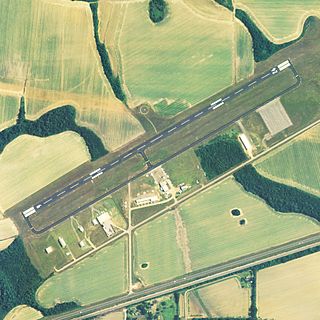
Currituck County Regional Airport is a county-owned, public-use airport in Currituck County, North Carolina, United States. It is located four nautical miles south of the central business district of Currituck, North Carolina. This airport is included in the National Plan of Integrated Airport Systems for 2011–2015, which categorized it as a general aviation facility. It was previously known as Currituck County Airport or Currituck Regional Airport.

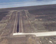
Rome State Airport is a public use airport located 20 nautical miles southwest of the central business district of Rome, in Malheur County, Oregon, United States. It is owned by the Oregon Department of Aviation.

Grider Field is a public airport five miles southeast of Pine Bluff, in Jefferson County, Arkansas. The FAA's National Plan of Integrated Airport Systems for 2009–2013 categorized it as a general aviation airport.

Needles Airport is a county-owned public airport in San Bernardino County, California, United States, five miles (9 km) south of Needles.
St. Elmo Airport is a state-owned public-use airport located two nautical miles west of the central business district of St. Elmo, in Mobile County, Alabama, United States. It is included in the FAA's National Plan of Integrated Airport Systems for 2011–2015, which categorized it as a general aviation facility.

La Junta Municipal Airport is three miles north of La Junta, in Otero County, Colorado, United States. The National Plan of Integrated Airport Systems for 2011–2015 categorized it as a general aviation facility.

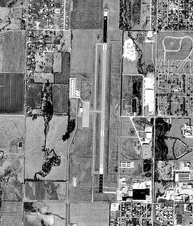
Crookston Municipal Airport, also known as Kirkwood Field, is a city-owned public-use airport located four nautical miles (7 km) north of the central business district of Crookston, a city in Polk County, Minnesota, United States.

Greenwood County Airport is a county-owned, public-use airport located three nautical miles (6 km) north of the central business district of Greenwood, a city in Greenwood County, South Carolina, United States. It is included in the National Plan of Integrated Airport Systems for 2011–2015, which categorized it as a general aviation facility. The airport does not have scheduled commercial airline service.

Darlington County Jetport is a county-owned, public-use airport located nine nautical miles north of the central business district of Darlington, a city in Darlington County, South Carolina, United States. It is included in the National Plan of Integrated Airport Systems for 2011–2015, which categorized it as a general aviation facility. The airport does not have scheduled commercial airline service.

Barnwell Regional Airport is a county-owned, public-use airport located 1 nautical mile northwest of the central business district of Barnwell, a city in Barnwell County, South Carolina, United States. It is owned by Barnwell County. The airport serves the general aviation community, with no scheduled commercial airline service.

Georgetown County Airport is a county-owned, public-use airport located three nautical miles (6 km) south of the central business district of Georgetown, a city in Georgetown County, South Carolina, United States. It is included in the National Plan of Integrated Airport Systems for 2011–2015, which categorized it as a general aviation facility. The airport does not have scheduled commercial airline service.

Grand Strand Airport is a county-owned, public-use airport located one nautical mile (1.85 km) northwest of the central business district of North Myrtle Beach, in Horry County, South Carolina, United States. The name Grand Strand refers to a nearby 60-mile stretch of beach.
Miami Municipal Airport is two miles northwest of Miami, in Ottawa County, Oklahoma. The National Plan of Integrated Airport Systems for 2011–2015 called it a general aviation facility.

C. David Campbell Field is six miles southeast of downtown Corsicana, in Navarro County, Texas It provides general aviation service.
Amedee Army Airfield is a military use airport located nine nautical miles (17 km) north of the central business district of Herlong, in Lassen County, California, United States. It is owned by the United States Army and located at the Sierra Army Depot in the Honey Lake Valley, east of the Sierra Nevada mountain range.


