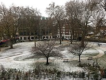
The 2-acre (0.8ha) square roughly covers a large 14th-century plague pit, discovered by deep excavations for Crossrail near which, within the main site, the history of the Charterhouse is exhibited in a branch of the Museum of London. The southern end of the square forms the southern boundary of the London Borough of Islington, where it meets the City of London.
Colour engraving circa 1770Map for fire risk, 1887
In 1371 a Carthusian monastery was founded by Walter de Manny on what is now the north side of the square. It was established near a 1348 plague pit,[1] which formed the largest mass grave in London during the Black Death, and tens of thousands of bodies were buried there. The common name for Carthusian monasteries, Charterhouse, was an Anglicisation of La Grande Chartreuse, whose order founded the monastery.[2]
In 2014 evidence of the large burial pit for plague victims dating from 1348 to 1350, the time of the Black death, was discovered under the square by workers building the Crossrail project.[5] Subsequent analysis of DNA and isotopes from the skeletons of those buried revealed data about Londoners who fell victim to the pandemic, such as their birthplace, diet, and the fact that there were actually three periods of plague burials, from 1348, 1361 and the early 15th century as outbreaks recurred.[6]
Charterhouse gives accommodation as an Almshouse to over forty single pensioners aged over sixty many of whom retain the tradition of having been "military men, schoolmasters, clergy, artists, musicians, writers and businessmen",[7] who are in financial, housing and social need but not in significant debt and keen to contribute to the community.[8] Additionally it has the Queen Elizabeth II Infirmary Care Home and private tenants in 9 commercial units, 13 flats and 3 houses.[9] The complex is open for pre-booked guided tours.[10] The chapel can be viewed as part of the annual Open House London event. The site extends far back from the north side of the square in restored buildings and garden courtyards of the old monastery/school.
Campus of Barts and The London School of Medicine and Dentistry
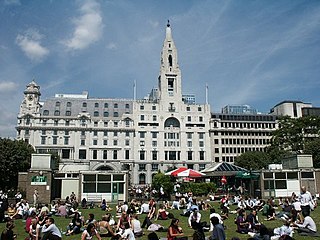
The Charterhouse Square campus of Queen Mary University of London starts at the north-east corner of the square and then spreads out; close to a café and few narrow houses fronting that side, it occupies new buildings and some of the former school buildings. It comprises student accommodation and departments of Barts and The London School of Medicine and Dentistry: Barts Cancer Institute (BCI),[11] the Wolfson Institute of Preventive Medicine[12] and the William Harvey Research Institute (WHRI).[13] The BCI and the Centre for Cancer Prevention (CCP) within the Wolfson Institute also make up the Cancer Research UK Barts Centre of Excellence, together with Barts and the London NHS Trust.[14] In 2018, the School received a £6.5 million grant from the Barts Charity to redevelop the campus.[15]
Smaller sites on the square
Florin Court
Florin Court, a residential building in the Art Deco style built in 1936 by Guy Morgan and Partners, is on the east side. The building has a concave façade, roof garden and basement swimming pool.[16]
↑ Guide to the Local Administrative Units of England, Frederic A Youngs Jr, Volume 1: Southern England, ISBN0-901050-67-9, Published by the Royal Historical Society – Publication describes the evolution of these units.
The Carthusians, also known as the Order of Carthusians, are a Latin enclosed religious order of the Catholic Church. The order was founded by Bruno of Cologne in 1084 and includes both monks and nuns. The order has its own rule, called the Statutes, and their life combines both eremitical and cenobitic monasticism. The motto of the Carthusians is Stat crux dum volvitur orbis, Latin for "The Cross is steady while the world turns". The Carthusians retain a unique form of liturgy known as the Carthusian Rite.
The London Borough of Islington is a London borough which forms part of Inner London, England. Islington has an estimated population of 215,667. It was formed in 1965, under the London Government Act 1963, by the amalgamation of the metropolitan boroughs of Islington and Finsbury.
Clerkenwell is an area of central London, England.
Finsbury is a district of Central London, forming the southeastern part of the London Borough of Islington. It borders the City of London.
Smithfield, properly known as West Smithfield, is a district located in Central London, part of Farringdon Without, the most westerly ward of the City of London, England.
Farringdon is a small district in Central London, the southern part of the London Borough of Islington. The term is used to describe the area around Farringdon station. Historically the district corresponded to southern Clerkenwell and the small parish of St Sepulchre Middlesex.
The Metropolitan Borough of Finsbury was a metropolitan borough within the County of London from 1900 to 1965, when it was amalgamated with the Metropolitan Borough of Islington to form the London Borough of Islington.
Pentonville is an area in North London, located in the London Borough of Islington. It is located 1.75 miles (2.82 km) north-northeast of Charing Cross on the Inner Ring Road. Pentonville developed in the northwestern edge of the ancient parish of Clerkenwell on the New Road. It is named after Henry Penton, the developer of the area.
The London Charterhouse is a historic complex of buildings in Farringdon, London, dating back to the 14th century. It occupies land to the north of Charterhouse Square, and lies within the London Borough of Islington. It was originally built a Carthusian priory, founded in 1371 on the site of a Black Death burial ground. Following the priory's dissolution in 1537, it was rebuilt from 1545 onwards to become one of the great courtyard houses of Tudor London. In 1611, the property was bought by Thomas Sutton, a businessman and "the wealthiest commoner in England", who established a school for the young and an almshouse for the old. The almshouse remains in occupation today, while the school was re-located in 1872 to Godalming, Surrey.
Charterhouse may refer to:
Thomas Sutton was an English civil servant and businessman, born in Knaith, Lincolnshire. He is remembered as the founder of the London Charterhouse and of Charterhouse School.
The London Borough of Islington is short of large parks and open spaces, given its status in recent decades as a desirable place of residence. In fact, Islington has the lowest ratio of open space to built-up areas of any London borough. The largest continuous open space in the borough, at 11.75 hectares, is Highbury Fields.
St Luke's is an area in central London in the Borough of Islington. It lies just north of the border with the City of London near the Barbican Estate, and the Clerkenwell and Shoreditch areas. The area takes its name from the now redundant parish church of St Luke's, on Old Street west of Old Street station. Following the closure of the church, the parish was reabsorbed into that of St Giles-without-Cripplegate, from which it had separated in 1733.
The parliamentary borough of Finsbury was a constituency of the House of Commons of the UK Parliament from 1832 to 1885, and from 1918 to 1950. The constituency was first created in 1832 as one of seven two-seat "metropolis" parliamentary boroughs other than the two which already existed: Westminster and the City of London; the latter until 1885 retained an exceptional four seats. Finsbury was directly north of the City of London and was smaller than the Finsbury division of the Ossulstone hundred but took in land of Holborn division to its southwest in pre-introduction changes by Boundary Commissioners. It included Finsbury, Holborn, Moorfields, Clerkenwell, Islington, Stoke Newington and historic St Pancras. The 1918 constituency corresponded to the smaller Metropolitan Borough of Finsbury ; it was a seat, thus electing a single member, fulfilling a longstanding aim of Chartism which underscored the 1832 reforms.
Florin Court is an Art Deco / Streamline Moderne residential building on the eastern side of Charterhouse Square in Smithfield, London.
Charterhouse Street is a street on the north side of Smithfield in the City of London. The road forms part of the City’s boundary with the neighbouring London Boroughs of Islington and Camden. It connects Charterhouse Square and Holborn Circus, crossing Farringdon Road and running along a number of historical sites, including Smithfield Market.
The Angel is an area on the northern fringes of Central London within the London Borough of Islington. It is 2 miles (3.2 km) north-northeast of Charing Cross on the Inner Ring Road at a busy transport intersection. The area is identified in the London Plan as one of 35 major centres in London. It is a significant commercial and retail centre, and a business improvement district. The Angel straddles the ancient boundary of the parishes of Clerkenwell and Islington that later became the metropolitan boroughs of Finsbury and Islington. It is named from the former Angel Inn which stood on the corner of Islington High Street and Pentonville Road. Since 1965 the whole area has formed part of the London Borough of Islington in Greater London.
The Charterhouse was a Carthusian monastery and almshouse in Kingston upon Hull, England, built just outside the town's walls. The hospital building survived the Dissolution of the Monasteries; the priory was destroyed in 1538. The structure of the hospital was destroyed before the first siege of Hull during the English Civil War. A replacement was built in 1645, which was replaced again in 1780; the buildings function as an almshouse with an attached chapel, and remain in use to the present day (2012).
This is a list of the etymology of street names and principal buildings in the London districts of Clerkenwell and Finsbury, in the London Borough of Islington. The Clerkenwell/Finsbury area has no formally defined boundaries - those used here are: Pentonville Road to the north, Goswell Road to the east, Clerkenwell Road to the south and Gray's Inn Road to the west. Finsbury was traditionally roughly the northern part of the area covered here, however in practice the name is rarely used these days.
This page is based on this Wikipedia article Text is available under the CC BY-SA 4.0 license; additional terms may apply. Images, videos and audio are available under their respective licenses.