Chatham, Michigan

Last updated

Chatham, Michigan
Chatham, MI location3.png
Location within Alger County
USA Michigan location map.svg
Red pog.svg
Chatham
Location within the state of Michigan
Usa edcp location map.svg
Red pog.svg
Chatham
Location within the United States
Coordinates: 46°20′49″N86°55′42″W / 46.34694°N 86.92833°W / 46.34694; -86.92833
CountryFlag of the United States.svg United States
State Flag of Michigan.svg  Michigan
County Flag of Alger County, Michigan.svg Alger
Township Rock River
Settled1896
Area
[1]
  Total2.45 sq mi (6.36 km2)
  Land2.45 sq mi (6.36 km2)
  Water0.00 sq mi (0.00 km2)
Elevation
876 ft (267 m)
Population
 (2020)
  Total193
  Density78.65/sq mi (30.37/km2)
Time zone UTC-5 (Eastern (EST))
  Summer (DST) UTC-4 (EDT)
ZIP code(s)
49816
Area code 906
FIPS code 26-14940 [2]
GNIS feature ID1619481 [3]

Chatham is a village in Alger County in the U.S. state of Michigan. It is located within Rock River Township. The population was 193 at the 2020 census.

Contents

The village is located along M-94 about 15 miles (24 km) southwest of the city of Munising. It was named after Chatham, Ontario, Canada, the town where the lumber company Sutherland Innis was headquartered.

History

The first settler came to Chatham in 1896, when the Munising Railway Company (later Lake Superior and Ishpeming) established a line through the town. The railroad company, along with the lumber company Sutherland Innis, platted a village where the railroad intersected the township road.

Logging was the major economic activity in the area throughout the late 19th and early 20th centuries, with Sutherland Innis, Cleveland-Cliffs Iron Company, Northwestern Cooperage and Lumber Company (Buckeye Company) and T.G. Sullivan having camps scattered throughout the area.

Geography

According to the United States Census Bureau, the village has a total area of 2.45 square miles (6.35 km2), all land. [4]

Climate

This climatic region is typified by large seasonal temperature differences, with warm to hot (and often humid) summers and cold (sometimes severely cold) winters. According to the Köppen Climate Classification system, Chatham has a humid continental climate, abbreviated "Dfb" on climate maps. [5]

Climate data for Chatham 1 SE, Michigan, 1991–2020 normals: 875ft (267m)
MonthJanFebMarAprMayJunJulAugSepOctNovDecYear
Record high °F (°C)48
(9)
58
(14)
81
(27)
79
(26)
89
(32)
90
(32)
94
(34)
94
(34)
90
(32)
82
(28)
76
(24)
54
(12)
94
(34)
Mean maximum °F (°C)39.5
(4.2)
42.3
(5.7)
54.1
(12.3)
69.5
(20.8)
81.4
(27.4)
85.8
(29.9)
88.6
(31.4)
87.4
(30.8)
83.1
(28.4)
73.3
(22.9)
57.9
(14.4)
43.4
(6.3)
87.6
(30.9)
Mean daily maximum °F (°C)23.6
(−4.7)
26.2
(−3.2)
34.9
(1.6)
46.6
(8.1)
61.4
(16.3)
70.5
(21.4)
75.5
(24.2)
74.5
(23.6)
67.0
(19.4)
53.2
(11.8)
39.8
(4.3)
29.0
(−1.7)
50.2
(10.1)
Daily mean °F (°C)16.2
(−8.8)
16.8
(−8.4)
25.5
(−3.6)
36.9
(2.7)
49.7
(9.8)
59.0
(15.0)
63.9
(17.7)
63.2
(17.3)
56.3
(13.5)
44.2
(6.8)
32.6
(0.3)
22.5
(−5.3)
40.6
(4.7)
Mean daily minimum °F (°C)8.7
(−12.9)
7.4
(−13.7)
16.1
(−8.8)
27.3
(−2.6)
38.1
(3.4)
47.5
(8.6)
52.4
(11.3)
52.0
(11.1)
45.6
(7.6)
35.1
(1.7)
25.3
(−3.7)
16.0
(−8.9)
31.0
(−0.6)
Mean minimum °F (°C)−12.8
(−24.9)
−18.7
(−28.2)
−10.1
(−23.4)
10.6
(−11.9)
23.9
(−4.5)
33.7
(0.9)
40.4
(4.7)
38.2
(3.4)
32.0
(0.0)
22.1
(−5.5)
6.5
(−14.2)
−6.6
(−21.4)
−20.5
(−29.2)
Record low °F (°C)−25
(−32)
−32
(−36)
−23
(−31)
−4
(−20)
20
(−7)
30
(−1)
35
(2)
34
(1)
27
(−3)
14
(−10)
−12
(−24)
−26
(−32)
−32
(−36)
Average precipitation inches (mm)2.54
(65)
1.91
(49)
2.07
(53)
2.79
(71)
3.39
(86)
3.52
(89)
3.33
(85)
2.89
(73)
4.04
(103)
4.42
(112)
3.37
(86)
2.70
(69)
36.97
(941)
Average snowfall inches (cm)45.60
(115.8)
29.70
(75.4)
18.60
(47.2)
11.80
(30.0)
0.60
(1.5)
0.00
(0.00)
0.00
(0.00)
0.00
(0.00)
0.00
(0.00)
2.50
(6.4)
18.90
(48.0)
36.30
(92.2)
164
(416.5)
Source 1: NOAA(Chatham Exp Farm 2 Snowfall) [6] [7]
Source 2: XMACIS (records & monthly max/mins) [8]

Demographics

Historical population
CensusPop.Note
1970 246
1980 31528.0%
1990 268−14.9%
2000 231−13.8%
2010 220−4.8%
2020 193−12.3%
U.S. Decennial Census [9]

2010 census

As of the census [10] of 2010, there were 220 people, 97 households, and 61 families residing in the village. The population density was 89.8 inhabitants per square mile (34.7/km2). There were 120 housing units at an average density of 49.0 per square mile (18.9/km2). The racial makeup of the village was 88.6% White, 0.9% African American, 7.3% Native American, and 3.2% from two or more races.

There were 97 households, of which 30.9% had children under the age of 18 living with them, 45.4% were married couples living together, 12.4% had a female householder with no husband present, 5.2% had a male householder with no wife present, and 37.1% were non-families. 33.0% of all households were made up of individuals, and 18.6% had someone living alone who was 65 years of age or older. The average household size was 2.27 and the average family size was 2.85.

The median age in the village was 44.3 years. 26.4% of residents were under the age of 18; 5.9% were between the ages of 18 and 24; 19.1% were from 25 to 44; 32.7% were from 45 to 64; and 15.9% were 65 years of age or older. The gender makeup of the village was 49.5% male and 50.5% female.

2000 census

As of the census [2] of 2000, there were 231 people, 98 households, and 64 families residing in the village. The population density was 87.6 inhabitants per square mile (33.8/km2). There were 116 housing units at an average density of 44.0 per square mile (17.0/km2). The racial makeup of the village was 94.37% White, 4.76% Native American, and 0.87% from two or more races. 58.5% were of Finnish, 12.5% German, 6.0% French and 5.5% English ancestry according to Census 2000. 92.3% spoke English and 7.7% Finnish as their first language.

There were 98 households, out of which 31.6% had children under the age of 18 living with them, 56.1% were married couples living together, 8.2% had a female householder with no husband present, and 33.7% were non-families. 29.6% of all households were made up of individuals, and 13.3% had someone living alone who was 65 years of age or older. The average household size was 2.36 and the average family size was 2.92.

In the village, the population was spread out, with 24.2% under the age of 18, 9.5% from 18 to 24, 22.5% from 25 to 44, 29.0% from 45 to 64, and 14.7% who were 65 years of age or older. The median age was 41 years. For every 100 females, there were 87.8 males. For every 100 females age 18 and over, there were 88.2 males.

The median income for a household in the village was $31,406, and the median income for a family was $37,188. Males had a median income of $28,125 versus $19,375 for females. The per capita income for the village was $14,266. About 4.9% of families and 8.4% of the population were below the poverty line, including 4.7% of those under the age of eighteen and 20.0% of those 65 or over.

Related Research Articles

Bradley is a town in Penobscot County, Maine, United States. It is part of the Bangor Metropolitan Statistical Area. The population was 1,532 at the 2020 census. The village of Bradley is in the northwestern corner of the town.

<span class="mw-page-title-main">Munising, Michigan</span> City in Michigan, United States

Munising is a city in the Upper Peninsula of the U.S. state of Michigan. The population was 1,986 at the 2020 census. It is the county seat of Alger County. The city is partially surrounded by Munising Township, but the two are administered autonomously.

<span class="mw-page-title-main">Douglas, Michigan</span> City in Michigan, United States

Douglas is a city in Allegan County in the U.S. state of Michigan. The population was 1,378 at the 2020 census. The city is surrounded by Saugatuck Township and the city of Saugatuck is adjacent on the north.

<span class="mw-page-title-main">Port Hope, Michigan</span> Village in Michigan, United States

Port Hope is a village in Huron County of the U.S. state of Michigan. The population was 267 at the 2010 census. The village is within Rubicon Township.

<span class="mw-page-title-main">Hersey, Michigan</span> Village in Michigan, United States

Hersey is a village in Osceola County in the U.S. state of Michigan. The population was 350 at the 2010 census. The village is located within Hersey Township.

<span class="mw-page-title-main">Zemple, Minnesota</span> City in Minnesota, United States

Zemple is a city in Itasca County, Minnesota, United States. The population was 93 at the 2010 census.

<span class="mw-page-title-main">Willow River, Minnesota</span> City in Minnesota, United States

Willow River is a city in Pine County, Minnesota, United States, at the confluence of the Kettle and Willow Rivers. The population was 415 at the 2010 census.

<span class="mw-page-title-main">Washington, Nebraska</span> Village in Washington County, Nebraska, United States

Washington is a village in Washington County, Nebraska, United States. The population was 150 at the 2010 census.

<span class="mw-page-title-main">Rossburg, Ohio</span> Village in Ohio, United States

Rossburg is a village in Darke County, Ohio, United States. The population was 159 at the 2020 census.

<span class="mw-page-title-main">Bradner, Ohio</span> Village in Ohio, United States

Bradner is a village in Wood County, Ohio, United States. The population was 971 at the 2020 census.

<span class="mw-page-title-main">Walbridge, Ohio</span> Village in Ohio, United States

Walbridge is a village in Wood County, Ohio, United States, within the Toledo metropolitan area. The population was 3,011 at the 2020 census.

<span class="mw-page-title-main">Meadow Bridge, West Virginia</span> Town in West Virginia, United States

Meadow Bridge is a town in Fayette County, West Virginia, United States. The population was 379 at the 2010 census. The first settler of the area was John Gwin, closely followed by Dan Griffin.

<span class="mw-page-title-main">Weyerhaeuser, Wisconsin</span> Village in Wisconsin, United States

Weyerhaeuser is a village in Rusk County, Wisconsin, United States. The population was 238 at the 2010 census.

<span class="mw-page-title-main">Exeland, Wisconsin</span> Village in Wisconsin, United States

Exeland is a village in Sawyer County, Wisconsin, United States. The population was 229 at the 2020 census.

<span class="mw-page-title-main">Wilson, St. Croix County, Wisconsin</span> Village in Wisconsin, United States

Wilson is a village in St. Croix County, Wisconsin, United States. The population was 184 at the 2010 census.

<span class="mw-page-title-main">Big Falls, Waupaca County, Wisconsin</span> Village in Wisconsin, United States

Big Falls is a village in Waupaca County, Wisconsin, United States. The population was 61 at the 2010 census.

<span class="mw-page-title-main">Otter Lake, Michigan</span> Village in Michigan, United States

Otter Lake is a village in the U.S. state of Michigan. The village is split between Marathon Township in Lapeer County to the east and Forest Township in Genesee County to the west. The population was 426 at the 2020 census.

<span class="mw-page-title-main">Catawba, Wisconsin</span> Village in Wisconsin, United States

Catawba is a village in Price County, Wisconsin, United States. The population was 110 at the 2010 census. The village is located within the Town of Catawba.

<span class="mw-page-title-main">Rib Lake, Wisconsin</span> Village in Wisconsin, United States

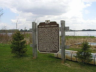
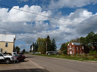
Rib Lake is a village in Taylor County, Wisconsin, United States located at the junction of Wisconsin Highway 102 and Taylor County Highway D. The population was 910 at the 2010 census. The village is completely surrounded by the Town of Rib Lake.

<span class="mw-page-title-main">Birchwood, Wisconsin</span> Village in Wisconsin, United States

Birchwood is a village in Washburn County, Wisconsin, United States. The population was 402 at the 2020 census. The village is located within the Town of Birchwood.

References

  1. "2020 U.S. Gazetteer Files". United States Census Bureau. Retrieved May 21, 2022.
  2. 1 2 "U.S. Census website". United States Census Bureau . Retrieved January 31, 2008.
  3. "US Board on Geographic Names". United States Geological Survey. October 25, 2007. Retrieved January 31, 2008.
  4. "US Gazetteer files 2010". United States Census Bureau. Archived from the original on January 25, 2012. Retrieved November 25, 2012.
  5. Climate Summary for Chatham, Michigan
  6. "Chatham 1 SE, Michigan 1991-2020 Monthly Normals" . Retrieved December 20, 2023.
  7. "Chatham Experiment Farm 2, Michigan 1991-2020 Monthly Normals" . Retrieved December 20, 2023.
  8. "xmACIS". National Oceanic and Atmospheric Administration. Retrieved December 20, 2023.
  9. "Census of Population and Housing". Census.gov. Retrieved June 4, 2015.
  10. "U.S. Census website". United States Census Bureau . Retrieved November 25, 2012.