
Elkridge is an unincorporated community and census-designated place (CDP) in Howard County, Maryland, United States. The population was 15,593 at the 2010 census. Founded early in the 18th century, Elkridge is adjacent to two other counties, Anne Arundel and Baltimore.

The Maryland Transit Administration (MTA) is a state-operated mass transit administration in Maryland, and is part of the Maryland Department of Transportation. The MTA operates a comprehensive transit system throughout the Washington-Baltimore metropolitan area. There are 80 bus lines serving the Baltimore Metropolitan Area, along with rail services that include the Light Rail, Metro Subway, and MARC Train. In 2023, the system had a ridership of 52,922,000, or about 186,900 per weekday as of the first quarter of 2024.
Cherry Hill often refers to:

Federal Hill is a neighborhood in Baltimore, Maryland, that lies just to the south of the city's central business district. Many of the structures are included in the Federal Hill Historic District, listed on the National Register of Historic Places in 1970. Other structures are included in the Federal Hill South Historic District, listed in 2003.

Bolton Hill is a neighborhood in Baltimore, Maryland, with 20 blocks of mostly preserved buildings from the late 19th century. It is listed on the National Register of Historic Places, preserved as a Baltimore City Historic District, and included within the boundaries of Baltimore National Heritage Area. The neighborhood is bounded by North Avenue, Mount Royal Avenue, Cathedral Street, Dolphin Street, and Eutaw Place. Bolton Hill is a largely residential neighborhood with three-story row houses with red brick, white marble steps, and high ceilings. There are also larger more ornate originally single-family houses, many houses of worship, parks, monuments, and a few large apartment buildings. Many significant residents have lived in the neighborhood, including F. Scott Fitzgerald, Woodrow Wilson, the Cone sisters, and Florence Rena Sabin.

Pigtown is a neighborhood in the southwest area of Baltimore, bordered by Martin Luther King Jr. Boulevard to the east, Monroe Street to the west, Russell Street to the south, and West Pratt Street to the north. The neighborhood acquired its name during the second half of the 19th century, when the area was the site of butcher shops and meat packing plants to process pigs transported from the Midwest on the B&O Railroad; they were herded across Ostend and Cross Streets to be slaughtered and processed.

Mondawmin is a neighborhood located in the Western district of Baltimore, Maryland, United States. The neighborhood is surrounded by Druid Hill Park, the Whitelock Community, and Lower Park Heights. Included within its boundaries are Frederick Douglass High School, and Mondawmin Mall. The Baltimore Metro Subway serves the neighborhood, with a station at Mondawmin Mall that is also a hub for many bus routes.

Mount Washington is an area of northwest Baltimore, Maryland. It is a designated city historic district and divided into two sections: South Road/Sulgrave to the southeast and Dixon's Hill to the north. The Mount Washington Historic District was listed on the National Register of Historic Places in 1990 with a boundary increase in 2001, with five contributing buildings and four contributing structures.

Hamilton Hills is a mixed-use suburban neighborhood located in the northeastern corner of Baltimore City, Maryland. Hamilton Hills represents a section of Hamilton, a larger historic area that includes other neighborhoods in Northeast Baltimore. The neighborhood's borders are Old Harford Road and Harford Road to the east, Echodale Avenue to the south, Perring Parkway to the west and the Baltimore County line to the north. The main thoroughfare in Hamilton Hills is Harford Road, which has been an integral part of the area's history.

Westport is a neighborhood in south Baltimore, Maryland. Westport is a majority African-American neighborhood that has struggled with crime, housing abandonment, and unemployment in the past decade. The neighborhood is bordered by the Middle Branch of the Patapsco River on the east, the city neighborhoods of Cherry Hill, Brooklyn and the southwestern Baltimore County community of Lansdowne to the southwest, Hollins Ferry Road and the Mount Winans and Lakeland neighborhoods to the west, and Interstate 95 to the north, along with the South Baltimore communities of Federal Hill and Otterbein. The Baltimore–Washington Parkway runs through the middle of Westport and intersects with Interstate 95, the main East Coast super-highway, north to south, Maine to Florida.

Middle East is a neighborhood in the heart of East Baltimore, Maryland.

Greenmount West is a neighborhood in the state-designated Station North Arts District of Baltimore. Its borders consist of Hargrove Alley to the west, Hoffman Street and the Amtrak railroad tracks to the south, the south side of North Avenue to the north, and Greenmount Avenue to the east. Residents in the area include a mix of low, middle and high income families, artists, commuters to Washington DC and working-class Baltimoreans with the majority of residents of African American descent.
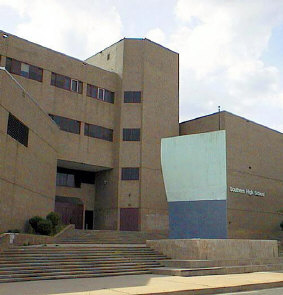
Southern High School was a former public secondary school on Warren Avenue between William Street to the west and Riverside Avenue to the east, in the Federal Hill neighborhood of the northern side of the larger old South Baltimore community on the Whetstone Point peninsula. With historic Fort McHenry from the War of 1812 (1812-1815), to the southeast at the point itself and additional residential areas surrounding the high school in tightly packed rowhouses and streets known as Locust Point and Riverside to the south and southeast along with the restored Otterbein and Sharp-Leadenhall neighborhoods to the west, also just south of the downtown central business district and famed "Inner Harbor" of the City of Baltimore, in Maryland.

Brooklyn is one of the southernmost neighborhoods in Baltimore, Maryland. It is located near Anne Arundel County along Governor Ritchie Highway which is also Maryland Route 2. Its main roads are South Hanover Street,, Potee Street, and East Patapsco Avenue, Sixth Street, Tenth Street, and West Bay Avenue which borders the neighboring Curtis Bay community to the east, running through Bay Brook Park, which separates the two. South Hanover Street also serves as the dividing line between east–west streets in Brooklyn, as Charles Street does not exist here.

Medfield is a neighborhood located in north Baltimore, Maryland, United States of America. It is located to the north of the trendy Hampden neighborhood and south of affluent Roland Park neighborhood. Its unofficial boundaries are Coldspring Lane to the north; Jones Falls Expressway to the west; Falls Road/Hickory Avenue to the east; and West 41st Street to the south.

Stadium/Federal Hill station is a Baltimore Light RailLink station in Baltimore, Maryland, located adjacent to M&T Bank Stadium. Although built to serve the stadium, it also provides access to the nearby Federal Hill and Pigtown neighborhoods.
MedStar Harbor Hospital is a private nonprofit, 150-bed, acute care teaching hospital in Baltimore City, Maryland, U.S. It is located on South Hanover Street along the Middle Branch of the Patapsco River in the Cherry Hill neighborhood of South Baltimore. The hospital has around 10,000 inpatients admissions and close to 60,000 emergency department visits per year. Its areas of specialty include orthopaedics, oncology, women's services, cardiology, internal medicine and neurosurgery. Harbor Hospital also offers a medical residency program in internal medicine and a transitional program that prepares residents to specialize in other areas.

Baltimore is the most populous city in the U.S. state of Maryland. With a population of 585,708 at the 2020 census, it is the 30th-most populous city in the United States. Baltimore was designated an independent city by the Constitution of Maryland in 1851, and is currently the most populous independent city in the nation. As of the 2020 census, the population of the Baltimore metropolitan area was 2,838,327, the 20th-largest metropolitan area in the country. When combined with the larger Washington metropolitan area, the Washington–Baltimore combined statistical area (CSA) has a 2020 U.S. census population of 9,973,383, the third-largest in the country.

The West Baltimore Innovation Village District is a neighborhood district of Baltimore City that will specialize in attracting startup companies and other employers to West Baltimore. Following the Death of Freddie Gray and the subsequent 2015 Baltimore protests, government leaders decided to launch the innovation district as a way to attract redevelopment and revitalization to the areas hardest hit by the protests. The district includes the neighborhoods of Mondawmin, Coppin Heights, Penn-North, Reservoir Hill and Bolton Hill.

Milton-Montford is a neighborhood in the heart of East Baltimore, Maryland. Milton-Montford lies north of Patterson Park and south of Amtrak's Northeast Corridor. The neighborhood is bounded by the neighborhoods of McElderry Park to the south, Madison-Eastend to the east, Biddle Street to the north, and Middle East to the west. The swath of land between Johns Hopkins Hospital and Frank C Bocek Park, which includes Milton-Montford, is often referred to as the "Down the Hill" neighborhood by local residents.


