
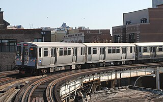
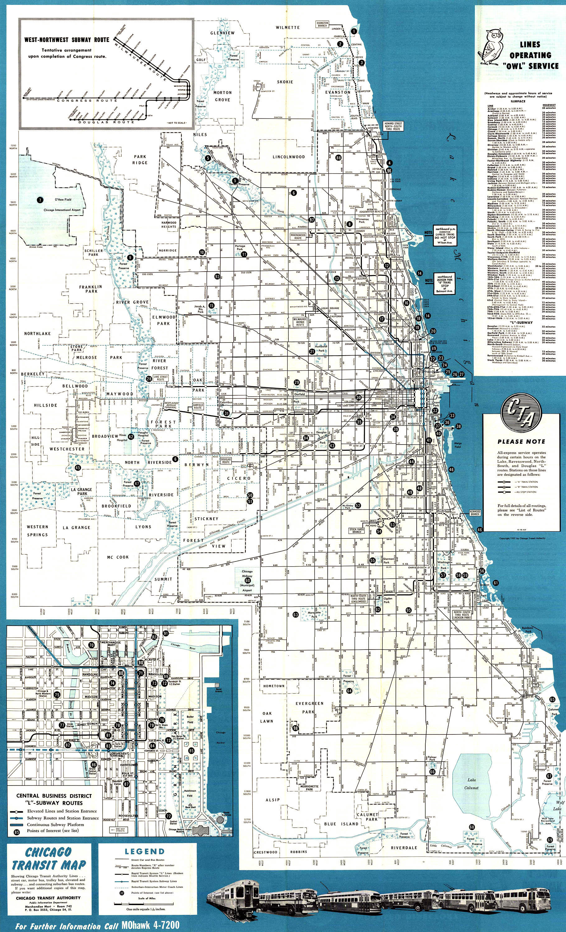
The Chicago "L" is the rapid transit system serving the city of Chicago and some of its surrounding suburbs in the U.S. state of Illinois. Operated by the Chicago Transit Authority (CTA), it is the fourth-largest rapid transit system in the United States in terms of total route length, at 102.8 miles (165.4 km) long as of 2014, and the third-busiest rapid transit system in the United States. In 2016, the "L" had 1,492 rail cars, eight different routes, and 145 train stations. In 2023, the system had 117,447,000 rides, or about 373,800 per weekday in the fourth quarter of 2023.
The Red Line is a rapid transit line in Chicago, run by the Chicago Transit Authority (CTA) as part of the Chicago "L" system. It is the busiest line on the "L" system, with an average of 93,457 passengers boarding each weekday in 2022. The route is 26 miles (42 km) long with a total of 33 stations. It runs elevated from the Howard station in the Rogers Park neighborhood on the North Side, through a subway on the Near North Side, Downtown, and the South Loop, and then through the Dan Ryan Expressway median to 95th/Dan Ryan in the Roseland neighborhood on the South Side.

The Blue Line is a 26.93-mile-long (43.34 km) Chicago "L" line which extends through The Loop from O'Hare International Airport at the far northwest end of the city, through downtown via the Milwaukee–Dearborn subway and across the West Side to its southwest end at Forest Park, with a total of 33 stations. At about 27 miles, it is the longest line on the Chicago "L" system and second busiest, and one of the longest local subway/elevated lines in the world. It has an average of 64,978 passengers boarding each weekday in 2022.

The Purple Line of the Chicago "L" is a 3.9-mile (6.3 km) route on the northernmost section of the system. The service normally begins from Linden in Wilmette and ends at Howard on Chicago's north border, passing through the city of Evanston.
The Chicago Central Area Transit Plan, generally referred to as the Chicago Central Area Transit Project (CCATP) in the 1970s, was an extensive study of the rapid transit system in downtown Chicago; the study had begun in 1965.

Loyola is a station on the Chicago Transit Authority's 'L' system, served by the Red Line. It is located at 1200 West Loyola Avenue in the Rogers Park neighborhood of Chicago, Illinois. The station has high ridership by students from the nearby Lakeshore Campus of Loyola University Chicago. The Red Line right-of-way runs directly through the southwest corner of the campus. Purple Line weekday rush hour express service use the outside tracks but do not stop at this station.

Montrose is a station on the Chicago Transit Authority's 'L' system. It is situated between the Damen and Irving Park stations on the Brown Line, which runs between Albany Park on Chicago's Northwest Side and downtown Chicago. It is an elevated station with two side platforms located at 1817 West Montrose Avenue in the Ravenswood neighborhood of Chicago's Lincoln Square community area.

Southport is a station on the Chicago Transit Authority's 'L' system. It is situated between the Paulina and Belmont stations on the Brown Line, which runs between Albany Park on Chicago's Northwest Side and downtown Chicago. It is an elevated station with two side platforms located at 3411 North Southport Avenue in Chicago's Lakeview community area.

Clark/Division is an "L" station on the CTA's Red Line. It is a subway station with one island platform located at 1200 North Clark Street, in the Near North Side neighborhood of Chicago, between the Gold Coast and Old Town. Much of Chicago's North Loop nightlife, including the Rush Street district and many bars and nightclubs are located close to the station.

North/Clybourn is an "L" station on the CTA's Red Line. It is a subway station with two side platforms, located at 1599 North Clybourn Avenue, in the Near North Side neighborhood of Chicago, at the southeastern edge of the commercial Clybourn Corridor. North/Clybourn station is located at the intersection of North Avenue, Halsted Street, and Clybourn Avenue. North/Clybourn was opened on October 17, 1943.

Grand, is an "L" station on the CTA's Red Line. It serves Navy Pier, which is accessible via bus on Illinois Street one block south.

Lake is an "L" station on the CTA's Red Line in the Chicago Loop that is part of the State Street subway. Lake is a transfer station between the Red Line and the Brown, Green, Orange, Pink, and Purple Lines at the State/Lake station and the Blue Line at Washington via the Chicago Pedway. In 2019, Lake had an average of 19,364 weekday passenger entries, making it the busiest 'L' station.

Monroe is an "L" station on the CTA's Red Line. The station opened on October 17, 1943, as part of the State Street subway. The station is located in the Chicago Loop, and is open 24/7.

Logan Square is a subway station on the Chicago Transit Authority's 'L' system, serving the Blue Line and the Logan Square neighborhood. It was the terminus of the Milwaukee Elevated until it was extended to Jefferson Park in 1970 via the Kennedy Expressway. From Logan Square, trains run at intervals of 2–7 minutes during rush-hour periods, and take 14 minutes to travel to the Loop. O'Hare bound trains take 26 minutes to reach the airport.

Washington is an 'L' station on the CTA's Blue Line. It is situated between the Clark/Lake and Jackson stations in the Milwaukee-Dearborn subway and is near the Richard J. Daley Center.

Pulaski is a station on the Chicago 'L' system, serving the Blue Line's Forest Park branch. The station is located in the median of the Eisenhower Expressway and serves the West Garfield Park neighborhood. A long ramp connects the platform to the station house on the Pulaski Road overpass. There was originally a similar entrance from the Keeler Avenue overpass; the entrance from Keeler was closed to cut costs on January 15, 1973, but retained as an exit, and the exit was fully closed on December 28, 1978. The structure for this exit still stands but it is closed to the public.

The State Street subway is an underground section of the Chicago "L" system in The Loop which serves as the center of the Red Line. It is 4.9 mi (7.9 km) long and has a boarding average of 53,601 passengers every weekday as of February 2013. It owes its name to State Street which it runs below. Since the subway is operated by the Red Line, it serves passengers 24 hours a day/7 days a week and 365 days a year.
The Humboldt Park branch was a rapid transit line which was part of the Chicago "L" system from 1895 to 1952. The branch served the West Town and the Humboldt Park neighborhoods of Chicago and consisted of six elevated stations. It opened on July 29, 1895, and closed on May 4, 1952.

The Chicago "L" used skip-stop service, wherein certain trains would stop only at certain designated stations on a route, from 1948 to 1995. It was implemented as a way to speed up travel within a route, and was one of the Chicago Transit Authority's first reforms upon its assumption of the "L"'s operations.

