Chilakaluripet

Last updated

Chilakaluripet
India Andhra Pradesh location map (current).svg
Red pog.svg
Chilakaluripet
Location in Andhra Pradesh, India
Coordinates: 16°05′21″N80°10′02″E / 16.08917°N 80.16722°E / 16.08917; 80.16722
Country India
State Andhra Pradesh
District Palnadu
Area
[1]
  Total15 km2 (6 sq mi)
Elevation
25 m (82 ft)
Population
 (2011) [2] [3]
  Total101,398
  Density6,800/km2 (18,000/sq mi)
Languages
  Official Telugu
Time zone UTC+5:30 (IST)
PIN
522 616
Vehicle registration AP-07
Website chilakaluripet.cdma.ap.gov.in/en

Chilakaluripet is a city in Palnadu district of the Indian state of Andhra Pradesh. It is the Mandal headquarters of Chilakaluripet Mandal in Narasaraopet Revenue Division. [4]

Contents

Geography

It is located in the Coastal Andhra region of the state at 16°06′N80°10′E / 16.10°N 80.16°E / 16.10; 80.16 in the on the Eastern coastal plains. Chilakaluripeta is located 40 km (25 mi) south-west of the district headquarters Guntur, and 75 kilometres (46 mi) south-west of Amaravati (state capital). [5] The Town is located in zone 3 as per Earthquake zones of India. Krishna River water from the Nagarjuna Sagar Right Canal is the main source of water for the residents. [6]

Demographics

As of 2011 Census of India, the town had a population of 101,550. The total population constitute, 50,201 males and 51,349 females. Average sex ratio is 1023 females per 1000 males, higher than the national average of 940 per 1000. [7] 9,525 children are in the age group of 0–6 years, of which 4,916 are boys and 4,609 are girls with a sex ratio of 938 per 1000. The average literacy rate stands at 72.08% with 52,106 literates, lower than the national average of 73.00%. [3] [8]

Civic administration

Chilakaluripet Municipality was constituted in 1964 as a third grade municipality, It was upgraded to second grade in 1980 and to first grade in 2001. The jurisdiction of the municipality is spread over an area of 18.13 km (11.27 mi) with 38 wards. [5] [1]

Politics

Chilakaluripet is a part of Chilakaluripet (Assembly constituency) for Andhra Pradesh Legislative Assembly. Vidadala Rajani is the present MLA of the constituency from YSRCP. [9] It comes under Narasaraopet (Lok Sabha constituency) which was won by Lavu Srikrishna Devarayala of YSRCP Party. [10] [11]

Economy

Chilakaluripet is a part of Vijayawada–Chilakaluripet growth corridor. [12] The municipality, along with Vijayawada and Guntur Municipal Corporations are a part of a 15 MW waste-to-energy plant project, planned to be set up with the collaboration of the JITF Urban Infrastructure Limited. [13]

Transport

The town has no rail network and mostly depends on road connectivity. The nearby railway stations are Guntur Jn Railway Station (40 km), Narasaraopet Railway station (21 km), Satuluru Railway station (25 km) and Chirala Railway station (40 km). National Highway 16 (India), a part of Golden Quadrilateral, passes through the city. [14] It has a total NH16 length of in the City 5 km (3.1 mi), and total length of Roads in the City 116.20 km (72.20 mi) [15] APSRTC operates buses from Chilakaluripet bus station. [16] [17] The National Highway 16, which connects Metropolitan cities Kolkata and Chennai. A part of Golden Quadrilateral highway network, a intersecting part of the Asian Highway 45, and State Highway 45 from Piduguralla to Chirala passes through the city.

Education

The primary and secondary school education is imparted by government, aided and private schools, under the School Education Department of the state. A Private English Medium School which was established long back at Chilakaluripet, Guntur in Andhra Pradesh, Recognised by Government of Andhra Pradesh. Chilakaluripeta is surrounded by many Degree, PG, Pharmacy And Engineering Colleges, Sadineni Chowdaraiah College of Arts Science PG Center (Maddirala), Modern Degree College (Modern Educational Institutions), DRNSCVS Degree College, AMG Degree College, Nikhila Degree College, Sharada College of Pharmaceutical Sciences (Kotappakonda), CR Engineering College (Ganapavaram).

See also

Related Research Articles

<span class="mw-page-title-main">Mangalagiri</span> Municipal Corporation in Andhra Pradesh, India

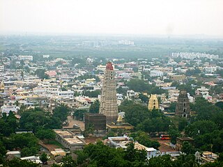
Mangalagiri is a major Sub-urban of Vijayawada in Guntur district of Indian state of Andhra Pradesh. The town is a part of Mangalagiri Tadepalli Municipal Corporation and part of Tenali revenue division. It and a part of Andhra Pradesh Capital Region. It is situated on National Highway 16 between Vijayawada and Guntur.

<span class="mw-page-title-main">Bhadrachalam</span> Temple town in Telangana, India

Bhadrachalam is a census town in Bhadradri Kothagudem district in the Indian state of Telangana. It is an important Hindu pilgrimage town with the Bhadrachalam Temple of Lord Rama, situated on the banks of Godavari river. It is located 312 kilometres (194 mi) east of state capital, Hyderabad,115 kilometres (71 mi) from Khammam,178 kilometres (111 mi) from Suryapet,180 kilometres (112 mi) from Warangal,187 kilometres (116 mi) from Vijayawada,220 kilometres (137 mi) and 350 kilometres (217 mi) from Visakhapatnam.

<span class="mw-page-title-main">Tenali</span> Town in Andhra Pradesh, India

Tenali is a city in Guntur district of the Indian state of Andhra Pradesh. It is a municipality and the headquarters of Tenali mandal and Tenali revenue division. The city is renowned for art, culture, drama, and hence, it is called Andhra Paris. It is one of the twelve urban local bodies in Andhra Pradesh Capital Region and the twelfth most populous town in the state, with a population of 199,345 as of 2011. Tenali town is also part of Andhra Pradesh Capital Region Development Authority (APCRDA).

<span class="mw-page-title-main">Amaravathi, Palnadu district</span> Village in Andhra Pradesh, India

Amaravathi is a village on the banks of the Krishna River, in the Palnadu district of the Indian state of Andhra Pradesh. It is the headquarters of Amaravathi mandal, and forms part of the Andhra Pradesh Capital Region with its headquarters at new Amaravati 35 km (22 mi) east, whose name is also borrowed from that of the older Amaravathi.

Bapatla is a city and district headquarters of Bapatla district in the Indian state of Andhra Pradesh. It is a municipality and the mandal headquarters of Bapatla mandal of Bapatla revenue division. The nearest towns and cities to Bapatla are Chirala, Ponnur, Tenali and Guntur of 17 km, 22 km, 50 km and 53 km respectively.

Narasaraopet is a city and district headquarters of Palnadu District of the Indian state of Andhra Pradesh. The town is a municipality and mandal headquarters of Narasaraopet mandal and Headquarters of Narasaraopet revenue division. The town also is the seat of the court of Additional District Judge. Narasaraopet acts as a melting point for the Palnadu and Delta regions of the district. The town is also referred as the 'Gateway of Palnadu'. The main offices of Nagarjuna Sagar Jawahar Canal Operation & Maintenance Lingamguntla Circle are located in this town.

Ponnur is a major city/town in Guntur district of the Indian state of Andhra Pradesh. A road to Chandole goes south-east and comes to Nidubrolu, where there is a temple with a stone bearing inscription recording the erection of 90 temple in A.D. 1132. An ancient Telugu manuscript entitled 'Ponnuru-Chandavolu Shasanam' was present in Potti Sreeramulu Telugu University. Kilari Venkata Rosaiah of YSRCP party is the current MLA of the constituency, who won the 2019 Andhra Pradesh Legislative Assembly election. It is a municipality and the mandal headquarter of Ponnur mandal under Tenali revenue division.

<span class="mw-page-title-main">Repalle</span> Town in Andhra Pradesh, India

Repalle is a town in Bapatla district of the Indian state of Andhra Pradesh. The town is one of the 12 municipalities in Bapatla district and the headquarters of Repalle mandal under the administration of Repalle revenue division. It is situated near Krishna River in the Coastal Andhra region of the state.

<span class="mw-page-title-main">Vinukonda</span> Town in Andhra Pradesh, India

Vinukonda is a town in Palnadu district of the Indian state of Andhra Pradesh. It is a municipality and the headquarters of Vinukonda mandal and administered under Narasaraopet revenue division.

<span class="mw-page-title-main">Chirala</span> City in Andhra Pradesh, India

Chirala, is a city in Bapatla district of the Indian state of Andhra Pradesh. It is a municipality and the headquarters of Chirala mandal in Chirala revenue division. As of 2011, it had a population of above 170,000.

Piduguralla is a town in Palnadu district of the Indian state of Andhra Pradesh.The town is the headquarters of Piduguralla mandal and administered under Gurazala revenue division. The town is also known as Lime City of India as there are abundant reserves of limestone. Nambula's family ruled piduguralla under palanadu kings.

Pedakakani is a village in the Guntur district of the Indian state of Andhra Pradesh. It is located in Pedakakani mandal of Guntur revenue division. Hindu shrine of Shiva, Sri Bhramaramba Malleswara Swamy Temple is located in the village.

<span class="mw-page-title-main">Tadepalle, Vijayawada</span> Municipal Corporation in Andhra Pradesh, India

Tadepalle is a major residential Area of the Vijayawada in Guntur district of Indian state of Andhra Pradesh. It is a major south sub urban of Vijayawada and a part of Vijayawada metropolitan area and Andhra Pradesh Capital Region. It is situated on National Highway 16 between Vijayawada and Guntur.

Addanki is a Municipal city in Bapatla district of the Indian State, Andhra Pradesh. Addanki North is the mandal headquarters of Addanki mandal in Addanki revenue division.

<span class="mw-page-title-main">Dhone</span> Town in Andhra Pradesh, India

Dhone or Dronachalam is a town in Nandyal district of the Indian state of Andhra Pradesh. It is a municipality located in Dhone mandal. And it is the head quarters of Dhone revenue division.

Sattenapalle is a town in Palnadu district of the Indian state of Andhra Pradesh. It is a municipality and the headquarters of Sattenapalle mandal under Sattenapalle revenue division. It is also part of APCRDA region.

<span class="mw-page-title-main">Pedavadlapudi</span> Village in Andhra Pradesh, India

Pedavadlapudi is a village in Guntur district of the Indian state of Andhra Pradesh. It is located in Mangalagiri mandal part of Mangalagiri Tadepalle Municipal Corporation part of Guntur revenue division.

Kondapaturu is a village in Kakumanu Mandal in the Guntur District of Andhra Pradesh, India. It is located 35 km (22 mi) south of the main district of Guntur, 3 km (1.9 mi) from Kakumanu, and 296 km (184 mi) from Hyderabad, the state capital. Between March and April, Thirunalla is celebrated by 200,000 to 300,000 visiting worshippers every year.

Narasaraopet mandal is one of the 28 mandals in Guntur district of the India state of Andhra Pradesh. It is under the administration of Narasaraopet revenue division and the headquarters are located at Narasaraopet city. The mandal is bounded by Rompicherla, Nekarikallu, Muppalla, Phirangipuram, Nadendla and Chilakaluripeta. It also borders Prakasam district.

Chilakaluripet mandal, officially designated as Chilakaluripet H/O Purshothama Patnam is one of the 28 mandals in Palnadu district of the Indian state of Andhra Pradesh. It is under the administration of Narasaraopet revenue division and the headquarters are located at Chilakaluripet city. The mandal is bounded by Nadendla, Edlapadu, Pedanandipadu and Narasaraopet mandals.

References

  1. 1 2 "Municipalities, Municipal Corporations & UDAs" (PDF). Directorate of Town and Country Planning. Government of Andhra Pradesh. Archived from the original (PDF) on 7 June 2016. Retrieved 29 January 2016.
  2. "District Census Handbook – Guntur" (PDF). Census of India. The Registrar General & Census Commissioner. pp. 14, 46. Retrieved 13 May 2016.
  3. 1 2 "Statistical Abstract of Andhra Pradesh, 2015" (PDF). Directorate of Economics & Statistics. Government of Andhra Pradesh. p. 43. Archived from the original (PDF) on 14 July 2019. Retrieved 26 April 2019.
  4. "Administrative divisions of Guntur district" (PDF). guntur.nic.in. Archived from the original (PDF) on 26 June 2014. Retrieved 16 January 2015.
  5. 1 2 "Chilakaluripet Municipality |". Chilakaluripet Municipality. Archived from the original on 8 November 2016. Retrieved 7 November 2016.
  6. Staff Reporter (24 March 2016). "Relief as water release begins from Sagar right canal". The Hindu. Retrieved 7 November 2016.
  7. "Sex Ratio". The Registrar General & Census Commissioner, India. Retrieved 29 August 2014.
  8. "Chapter–3 (Literates and Literacy rate)" (PDF). Registrar General and Census Commissioner of India. Retrieved 29 August 2014.
  9. "MLA". AP State Portal. Archived from the original on 8 October 2014. Retrieved 13 October 2014.
  10. "MP (Lok Sabha)". Government of AP. Archived from the original on 21 November 2016. Retrieved 4 May 2015.
  11. "Delimitation of Parliamentary and Assembly Constituencies Order, 2008" (PDF). Election Commission of India. p. 22,31. Retrieved 11 October 2014.
  12. "Need to enforce building rules: VGTM-UDA vice-chief". The Hindu. Guntur. 14 July 2012. ISSN   0971-751X . Retrieved 5 April 2016.
  13. "Waste-to-energy plant to be set up in Guntur". The Hindu. 7 February 2016. Retrieved 18 February 2016.
  14. "National Highways Development Project Map". National Highways Authority of India. Archived from the original on 4 March 2016. Retrieved 17 April 2017.
  15. "Details of Roads in each ULB of Andhra Pradesh". Commissioner and Directorate of Municipal Administration. Municipal Administration and Urban Developmemt Department - Government of Andhra Pradesh. Archived from the original on 1 August 2016. Retrieved 28 March 2017.
  16. "Bus Stations in Districts". Andhra Pradesh State Road Transport Corporation. Archived from the original on 22 March 2016. Retrieved 8 March 2016.
  17. Srinivas, Rajulapudi (25 October 2013). "25 passengers rescued from stranded APSRTC bus in Narsaraopet". The Hindu. Guntur. Retrieved 8 March 2016.