
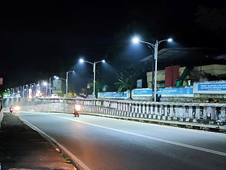
Attingal is a municipality in Thiruvananthapuram metropolitan area in Thiruvananthapuram district of Kerala state, India. It was the location of the Attingal kingdom, under Travancore. It is the headquarters of Chirayinkeezhu Taluk, and the important government institutions of the taluk such as the Taluk office, court complex, office of the deputy superintendent of Police, civil station, and treasuries are situated in Attingal. It is one of the oldest municipalities of Kerala which was constituted prior to its independence in 1924. In 1914 itself Attingal Town Improvement Authority (TIA) was formed which was the term used before the municipality regulation act of 1922. Attingal Town is located 25 kilometres (16 mi) north of Thiruvananthapuram. Attingal is the 3rd densely populated municipality in the district.
Varkala is a major coastal municipality situated in the northern suburb of Trivandrum, capital city of the Indian state of Kerala. It is the headquarters of Varkala Taluk and important government institutions such as the taluk office, court complex, office of the Deputy Superintendent of Police, Legal Metrology Inspector office, Excise Circle and Range office, RTO, Treasury and Mini civil station are situated in here. It is one among the oldest municipalities of Kerala established on 1980.
Kollam district, is one of 14 districts of the state of Kerala, India. The district has a cross-section of Kerala's natural attributes; it is endowed with a long coastline, a major Laccadive Sea seaport and an inland lake. The district has many water bodies. Kallada River is one among them, and the east side land of river is East Kallada and the west side land is West Kallada.

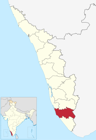
Thiruvananthapuram District, is the southernmost district in the Indian state of Kerala. The district was created in 1949, with its headquarters in the city of Thiruvananthapuram, which is also Kerala's administrative centre. The present district was created in 1956 by separating the four southernmost Taluks of the erstwhile district to form Kanyakumari district. The city of Thiruvananthapuram is also known as the Information technology capital of the State, since it is home to the first and largest IT park in India, Technopark, established in 1990. The district is home to more than 9% of total population of the state.
Adoor is a municipality in the Pathanamthitta district of Kerala, India. It is the headquarters of the Adoor Taluk and Adoor Revenue Division. Adoor is located 13.2 km (8.2 mi) southwest of the district headquarters Pathanamthitta and 78.1 km (48.5 mi) north of the state capital Thiruvananthapuram.

Parippally is a village in Kalluvathukal Panchayath of Kollam district, Kerala, India. Paripally village is situated 22 kilometres (14 mi) South of Kollam City along NH66 and 44 kilometres (27 mi) North of Trivandrum along NH66. Kollam Govt. Medical College is situated in Parippally. Kerala's new No 1 theatre Revathy Cinemax is also situated in Parippally-Kulamada(Kulamada-only 1 kilometre away from Parippally junction). The nearest town Chathannor is located 3 kilometres (1.9 mi) away, Kottiyam is another major town located near Parippally.

Kottarakkara, also transliterated as Kottarakara, is a town and municipality in the Kollam district of the Kerala, India. The town is close to Kollam Port, which has a rich history linked to the early medieval period as well as the reputation as an important commercial, industrial and trading center. Kottarakkara lies 27 kilometres (17 mi) to the east of Kollam city centre.

Kilimanoor is a panchayat and a town in the Chirayinkeezhu taluk of Thiruvananthapuram district in Kerala, India. It is located on MC/SH 1 Road, 33 kilometres (21 mi) North-west of the city of Thiruvananthapuram (Trivandrum), 14 km (8.7 mi) east of Attingal and 20 km (12 mi) east of Varkala.
Pattazhy, also Pattazhi is a village located in Pathanapuram taluk in the eastern part of the Kollam District, Kerala state, India. It is best known as the site of an ancient Bhagavathy temple, Pattazhy Devi Temple.
Pakalkuri is a charming village situated in the eastern part of Varkala Taluk in Thiruvananthapuram District in Kerala, India. It is situated 20km east of Varkala Town on the banks of the river Ithikkara and well known for its serene beauty and landscape. The river Ithikkara, which originates from the Western Ghats, separates Thiruvananthapuram and Kollam Districts at Pakalkuri in its meandering to the Arabian sea.

Edava is a panchayat in Varkala Taluk of Trivandrum district in the state of Kerala, India. Edava is located 5km north of Varkala, 21km south of port city Kollam and 44km north of capital city Trivandrum. Kappil beach is a famous surf location.Surfsupkerala life saving club operates here.

Kadakkavoor is a developing special grade town consisting central government postal office, railway station, sub treasury, police station, electricity board, telecom office and banks; Thiruvananthapuram district in the state of Kerala, India.
Akathumuri is a scenic lakeside village and an education hub in Cheruniyoor panchayat of Varkala Taluk in Thiruvananthapuram district of Kerala, India. Village is situated 7 km (4.3 mi) south of Varkala city centre and 39 km (24 mi) north of Trivandrum City.
Kappil is a seashore tourist spot located in Thiruvananthapuram district, Kerala, India. It is located in Edava Panchayat of Varkala Taluk. It is 18 km (11 mi) south and 45 km north of Kollam and Thiruvananthapuram cities respectively. Varkala railway station is the major railway station near Kappil.

Anchuthengu, formerly known as Anjengo, Angengo or Anjenga, is a coastal panchayath and town in the Thiruvananthapuram District of Kerala. It is situated 9km south-west of Varkala Town along Trivandrum - Varkala - Kollam coastal highway.
Venjaramoodu is a north-east suburb of Trivandrum city, the capital of Kerala. It is 9 km (5.6 mi) east of Attingal, 11 km (6.8 mi) northwest of Nedumangad, 12 km (7.5 mi) northeast of Trivandrum City and 26 km (16 mi) south-east of Varkala.
Ponganadu is a village in the Thiruvananthapuram district, situated in the Indian state of Kerala. Madavoor (5 km), Nagaroor (6 km), Karavaram (7 km), Pulimath (7 km), Navaikulam (7 km) are other villages near Ponganadu. Ponganadu is surrounded by Chadayamangalam Taluk to the north, Varkala Taluk to the west, Vamanapuram Taluk to the east and Chirayinkeezhu Taluk to the south.
Varkala Sivagiri railway station, station code VAK, is a major railway station in Kerala serving the town of Varkala in Thiruvananthapuram. It is the second-busiest railway station in the state capital district Trivandrum in terms of passenger movement and 14th busiest in Kerala State. Around 54 trains halts in this station which handled more than 17,730 passengers daily with 3 platforms. It is on Kollam–Thiruvananthapuram trunk line. Station is well connected to major metropolitan & tier 2 cities like Trivandrum, Hyderabad, Kochi, Delhi, Bangalore, Mangalore, Chennai, Mumbai, Vijayawada, Kolkata, Goa etc.

Kollam Junction railway station is a junction station situated in the city of Kollam in Kerala, India. It is the second largest railway station in Kerala in terms of area and largest in terms of number of tracks and one of the oldest railway stations in the state. It is also the second busiest railway station in Kerala in terms of trains handled per day. World's third longest railway platform is situated at Kollam railway station.
Nedungolam or Nedumgolam is the Northern border town of Paravur municipality in the Kollam district of Kerala state, India. Nedungolam is very near to the world-famous-wetland in Kollam district, Polachira, which is a favorite destination for migratory birds. A census conducted on 2003 reveals that over 26,000 birds belonging to 37 species are visiting or living in the Polachira wetlands.


