Chittagong District

Last updated

Chittagong District
চট্টগ্রাম জেলা
Chattogram District
Skyline Chittagong.png
aandrkillaa shaahii jaame msjid (ddaan paarsher minaar).jpg
Chandranath Temple At Sitakunda (6).jpg
Mohamaya Lake , Mirsharai ,Chittagong,Bangladesh.jpg
Karnaphuli River at night (01).jpg
Clockwise from top-left: View of Agrabad, Anderkilla Shahi Jame Mosque, Mahamaya Lake, Port of Chittagong, Chandranath Temple at Sitakunda
Government Seal of Bangladesh.svg
BD Chittagong District locator map.svg
Chittagong District
Expandable map of Chittagong District
Coordinates: 22°20′15″N91°50′20″E / 22.3375°N 91.8389°E / 22.3375; 91.8389
CountryFlag of Bangladesh.svg  Bangladesh
Division Chittagong Division
Seat Chittagong
Government
   Divisional Commissioner Md. Tofayel Islam
   Deputy Commissioner Abul Bashar Mohammad Fakhruzzaman
   District Council Chairman A.T.M. Pearul Islam
Area
  Total5,282.92 km2 (2,039.75 sq mi)
  Rank2
Population
 (2022 census) [1]
  Total9,169,464
  Rank2
  Density1,700/km2 (4,500/sq mi)
Time zone UTC+06:00 (BST)
HDI (2019)0.654 [2]
medium · 3rd of 20
Website chittagong.gov.bd

Chittagong District, renamed the Chattogram District, [3] is a district located in south-eastern Bangladesh. It is a part of the Chittagong Division. The port city of Chittagong, which is the second largest city in Bangladesh, is located within this district.

Contents

History

Because of the natural harbour, Chittagong had been an important location for trade, drawing Arab traders as early as the 9th century CE. The region fell under the rule of kings from Arakan in the 16th and 17th centuries, but later, the Mughal Army under Shaista Khan conquered Chittagong. During the 17th century, the region also faced a lot of attacks by Portuguese pirates. The Mughals established Chittagong as a district in 1666. Chittagong is the 2nd largest district in Bangladesh by population and area. The Chittagong Hill Tracts were separated from Chittagong in 1860. In 1947, Chittagong came under Pakistan and became part a district of East Pakistan. Port of Chittagong was a big spot for exports and imports of Pakistan. After the liberation of Bangladesh, Cox's Bazar District was separated in 1984. [4]

Administration

Subdivisions

There are 15 upazilas [7] and 31 thanas [8] within Chittagong District. There are 16 Thanas for the Chattogram Metropolitan Police covered area including the Karnaphuli Upazila, 2 for Mirsharai Upazila, and 1 for each of the remaining 13 upazilas.

The upazilas are:

  1. Anwara Upazila
  2. Banshkhali Upazila
  3. Boalkhali Upazila
  4. Chandanaish Upazila
  5. Fatikchhari Upazila
  6. Hathazari Upazila
  7. Karnaphuli Upazila [9]
  8. Lohagara Upazila
  9. Mirsharai Upazila
  10. Patiya Upazila
  11. Rangunia Upazila
  12. Raozan Upazila
  13. Sandwip Upazila
  14. Satkania Upazila
  15. Sitakunda Upazila

The thanas for the Chattogram Metropolitan Police covered area are:

  1. Akbar Shah Thana
  2. Bakoliya Thana
  3. Bandar Thana
  4. Bayazid Bostami Thana
  5. Chandgaon Thana
  6. Chawkbazar Thana
  7. Chittagong Kotwali Thana
  8. Double Mooring Thana
  9. EPZ Thana
  10. Halishahar Thana
  11. Karnaphuli Thana
  12. Khulshi Thana
  13. Pahartali Thana
  14. Panchlaish Thana
  15. Patenga Thana
  16. Sadarghat Thana

The thanas for the Mirsharai Upazila are:

  1. Jorargonj Thana
  2. Mirsharai Thana

Demographics

Historical population
YearPop.±% p.a.
1974 3,506,150    
1981 4,465,158+3.51%
1991 5,296,127+1.72%
2001 6,612,140+2.24%
2011 7,616,352+1.42%
2022 9,169,464+1.70%
Sources: [1] [10]

According to the 2022 Census of Bangladesh, Chittagong District had 2,143,958 households and a population of 9,169,464, 53.3% of whom lived in urban areas. The population density was 1,736 people per km2. The literacy rate (age 7 and over) was 80.9%, compared to the national average of 74.7%. [1]

Religion

Religions in Chittagong District (2011) [10]
ReligionPercent
Muslims
84.90%
Hindus
13.31%
Buddhists
1.59%
Other or not stated
0.20%
Religion in present-day Chittagong district [lower-alpha 1]
ReligionPopulation (1941) [11] :102–103Percentage (1941)Population (2011) [10] Percentage (2011)
Islam Star and Crescent.svg 1,402,13072.49%6,618,65786.90%
Hinduism Om.svg 470,02624.30%961,49413.31%
Buddhism Dharma Wheel (2).svg ------121,1691.59%
Others [lower-alpha 2] 62,2123.22%15,0320.20%
Total Population1,934,368100%7,616,352100%

Chittagong is multi-religious. Muslims are in majority with 86.90%, while Hindus and Buddhists are 11.31% and 1.59% respectively. Chittagong has the largest population of Hindus of any district in Bangladesh. Most of the Buddhists are Baruas and their population is decreasing with emigration, while Muslims and Hindus are both increasing in numbers, with Hindus growing more slowly.

Chittagong District has 13,148 mosques, 1025 Hindu temples, 535 Buddhist temples and 192 churches. Fakira Mosque in Hathazari, Musa Khan Mosque, Hafez Para Jame Mosque in Putibila, LOHAGARA, Kura Katni Mosque, Hashimpur Kadam Rasool Mosque in Chandanaish, the 16th century Kala Mosques, Chhuti Khan Mosque, Kadam Mobara Mosque, Andar Killah Mosque, Bakshi Hamid Mosque of Bashkhali, and East Gomdandi Chowdhury Para Old Mosque of Boalkhali are famous mosques in Chittagong. Also Badar Awlia Dargah is a tomb in Chittagong. [12]

The ethnic population is 32,165, consisting mainly of Tripuris and Chakmas.

Language in Chittagong District (1931) [13]

   Bengali (98.17%)
   Assam-Burmese (1.31%)
   Hindustani (0.32%)
   Naipali (0.04%)
   Dravidian languages (0.02%)
  Others (0.15%)

Education

Colleges

Universities

Others

Language and culture

The official language of Chittagong is Standard Bengali and the local variety spoken here is known as Chittagonian. [14] It has its own grammar, phonology and vocabulary.

Notable people

See also

Notes

  1. Sadar subdivision of Chittagong district and Sandwip thana of Noakhali district
  2. Including Jainism, Christianity, Buddhism, Zoroastrianism, Judaism, Ad-Dharmis, or not stated

Related Research Articles

<span class="mw-page-title-main">Sirajganj District</span> District of Bangladesh in Rajshahi Division

Sirajganj District is a district in the North Bengal region of Bangladesh, located in the Rajshahi Division. It is an economically important district of Bangladesh. Sirajganj district is the 25th largest district by area and 9th largest district by population in Bangladesh. It is known as the gateway to North Bengal.

<span class="mw-page-title-main">Sandwip</span> Island in Bangladesh

Sandwip is an island located along the southeastern coast of Bangladesh in the Chattogram District. Along with the island of Urir Char, it is part of the Sandwip Upazila.

<span class="mw-page-title-main">Chattogram City Corporation</span> Local governing body of Chattogram, Bangladesh

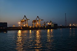
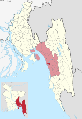
Chattogram City Corporation (CCC) is a self-governing body that governs the municipal areas of Chattogram and some adjoining areas of south-eastern Bangladesh. The CCC government is elected by popular vote every five years.

<span class="mw-page-title-main">Boalkhali Upazila</span> Upazila in Chattogram Division, Bangladesh

Boalkhali is an upazila of Chattogram District in Chattogram Division, Bangladesh.

<span class="mw-page-title-main">Chandanaish Upazila</span> Upazila in Chattogram Division, Bangladesh

Chandanaish is an upazila of Chattogram District in Chattogram Division, Bangladesh.

Chandgaon is a thana of Chattogram District in Chattogram Division, Bangladesh. It comprises the Chandgoan Residential Area and the Kalurghat Industrial Area.

<span class="mw-page-title-main">Fatikchhari Upazila</span> Upazila in Chittagong Division, Bangladesh

Fatikchari(Bengali: ফটিকছড়ি, romanized: Fôṭikchhôṛi) is an upazila of Chittagong District in Chittagong Division, Bangladesh.

<span class="mw-page-title-main">Lohagara Upazila, Chittagong</span> Upazila in Chattogram Division, Bangladesh

Lohagara is an upazila of Chattogram District in Chattogram Division, Bangladesh. Lohagara is situated between Chattogram and Cox's Bazar. It is one of the largest and most densely populated upazilas of Bangladesh. It has headquarters in Lohagara.

<span class="mw-page-title-main">Mirsharai Upazila</span> Upazila in Chattogram Division, Bangladesh

Mirsharai Upazila is an upazila of Chattogram District in Chattogram Division, Bangladesh. It comprises two police stations and two municipalities.

<span class="mw-page-title-main">Rangunia Upazila</span> Upazila in Chattogram Division, Bangladesh

Rangunia is an upazila of Chattogram District in Chattogram Division, Bangladesh.

<span class="mw-page-title-main">Raozan Upazila</span> Upazila in Chattogram Division, Bangladesh

Raozan Upazila is an upazila of Chattogram District, in Chattogram Division, Bangladesh. It was established in 1947.

<span class="mw-page-title-main">Sandwip Upazila</span> Upazila in Chattogram Division, Bangladesh

Sandwip is an upazila of Chattogram District in Chattogram Division, Bangladesh. It encompasses the islands of Sandwip and Urir Char.

<span class="mw-page-title-main">Satkania Upazila</span> Upazila in Chattogram Division, Bangladesh

Satkania is an upazila of Chattogram District in Chattogram Division, Bangladesh.

<span class="mw-page-title-main">Sitakunda Upazila</span> Upazila in Chattogram Division, Bangladesh

Sitakunda is an upazila in the Chattogram District of Chattogram Division, Bangladesh. It includes one urban settlement, the Sitakunda Town, and 10 unions. Sitakunda is the home of the country's first eco-park, as well as alternative energy projects, specifically wind energy and geothermal power.

<span class="mw-page-title-main">Bishwanath Upazila</span> Upazila in Sylhet, Bangladesh

Bishwanath is an upazila of Sylhet District in the Division of Sylhet, Bangladesh.

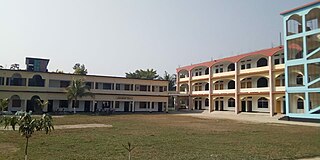
Halishahar Housing Estate is a thana of Chattogram District in Chattogram Division, Bangladesh. Halishahar Housing Estate is a large residential area in Chattogram.

<span class="mw-page-title-main">Karnaphuli Upazila</span> Upazila in Chattogram Division, Bangladesh

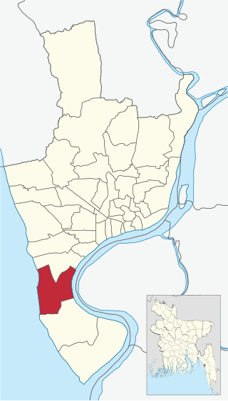
Karnaphuli is an Upazila of Chattogram District in Chattogram Division, Bangladesh. Administration Karnaphuli Thana was established on 27 May 2000. Karnaphuli, a police station area under Chattogram's Patiya, has been upgraded to an Upazila.

<span class="mw-page-title-main">Chittagong-13</span> Constituency of Bangladeshs Jatiya Sangsad

Chittagong-13 is a constituency represented in the Jatiya Sangsad of Bangladesh since 2014 by Saifuzzaman Chowdhury of the Awami League.

<span class="mw-page-title-main">Chittagong-14</span> Bangladeshi parliamentary constituency

Chittagong-14 is a constituency represented in the Jatiya Sangsad of Bangladesh since 2014 by Nazrul Islam Chowdhury of the Awami League.

<span class="mw-page-title-main">South Halishahar Ward</span> Chattogram City Corporation in Chittagong Division, Bangladesh

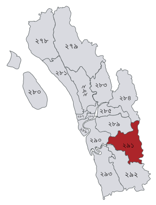
South Halishahar is a No.39 Ward of Chattogram City Corporation and a part of Halishahar Thana, Bangladesh.

References

  1. 1 2 3 Population and Housing Census 2022: Preliminary Report. Bangladesh Bureau of Statistics. August 2022. pp. viii, 29, 38, 45. ISBN   978-984-35-2977-0.
  2. "Sub-national HDI - Area Database - Global Data Lab". hdi.globaldatalab.org. Retrieved 18 March 2020.
  3. Mahadi Al Hasnat (2 April 2018). "Mixed reactions as govt changes English spellings of 5 district names". Dhaka Tribune. Retrieved 8 April 2018.
  4. Mohammad Mahibbullah Siddiqi (2012). "Cox's Bazar District". In Sirajul Islam and Ahmed A. Jamal (ed.). Banglapedia: National Encyclopedia of Bangladesh (Second ed.). Asiatic Society of Bangladesh.
  5. "AL men appointed administrators". The Daily Star. 16 December 2011.
  6. মো. ইলিয়াস হোসেন চট্টগ্রাম বিভাগের শ্রেষ্ঠ জেলা প্রশাসক. Chittagong Pratidin (in Bengali). 27 January 2020. Retrieved 5 July 2020.
  7. Jasim Uddin Harun (2012). "Chittagong District". In Sirajul Islam and Ahmed A. Jamal (ed.). Banglapedia: National Encyclopedia of Bangladesh (Second ed.). Asiatic Society of Bangladesh.
  8. "Home Minister to launch 4 new thanas in Ctg tomorrow". The Financial Express. 29 May 2013.
  9. "Karnaphuli becomes Bangladesh's 490th Upazila". bdnews24.com. 9 May 2016.
  10. 1 2 3 "Bangladesh Population and Housing Census 2011 Zila Report – Chittagong" (PDF). bbs.gov.bd. Bangladesh Bureau of Statistics.
  11. "Census of India, 1941 Volume VI Bengal Province" (PDF).
  12. চট্টগ্রামের সবচেয়ে প্রাচীন ইমারত. Prothom Alo (in Bengali). 22 August 2013. Retrieved 5 July 2020.
  13. Census of India 1931
  14. Masica, Colin (1991). The Indo-Aryan Languages. Cambridge: Cambridge University Press. p. 16. "The dialect of Chittagong, in southeast Bangladesh, is different enough to be considered a separate language."
  15. "Nurul Abedin Profile". ESPNcricinfo.