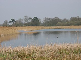
Redgrave and Lopham Fens is a 127 hectare biological Site of Special Scientific Interest between Thelnetham in Suffolk and Diss in Norfolk. It is a national nature reserve, a Ramsar internationally important wetland site, a Nature Conservation Review site, Grade I, and part of the Waveney and Little Ouse Valley Fens Special Area of Conservation. It is managed by the Suffolk Wildlife Trust.
Worcestershire Wildlife Trust is one of 46 wildlife trusts throughout the United Kingdom. It was founded in 1968 to conserve, protect and restore the county's wildlife.

The Macquarie Marshes Nature Reserve is a protected natural wetland reserve that is located within the Macquarie Marshes, in the region along the lower Macquarie River in northwestern New South Wales, Australia. The 19,824-hectare (48,990-acre) reserve is situated approximately 600 kilometres (370 mi) northwest of Sydney and 100 kilometres (62 mi) north of Warren.

The Cotswold Water Park is the United Kingdom's largest marl lake system, straddling the Wiltshire–Gloucestershire border, northwest of Cricklade and south of Cirencester. There are 180 lakes, spread over 42 square miles (110 km2).

Loynton Moss is a nature reserve of the Staffordshire Wildlife Trust, near the village of Woodseaves, in Staffordshire, England. It is adjacent to the Shropshire Union Canal, as it runs from nearby Norbury to High Offley.

Coombe Hill Canal lies in the Vale of Gloucester, south west England, north of Leigh and runs west 2.75 miles (4.43 km) from Coombe Hill Basin to the River Severn near Wainlode Hill. It opened in 1796 and closed 80 years later in 1876, after the only lock was damaged by flooding. The Gloucestershire Wildlife Trust purchased the Coombe Hill Canal nature reserve in 1985 and the area is managed by the trust. Adjacent to the Coombe Hill Canal is a large area of wet meadowland situated midway between Gloucester and Tewkesbury to the west of the A38, which was purchased by the trust in 1999. There is a north and a south meadow. This land and the Canal itself often flood in winter, which attracts hundreds of wildfowl.

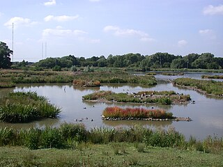
Sevenoaks Gravel Pits is a 73.7-hectare (182-acre) biological Site of Special Scientific Interest on the northern outskirts of Sevenoaks in Kent. It is managed by Kent Wildlife Trust as the Sevenoaks Wildlife Reserve and Jeffery Harrison Visitor Centre.

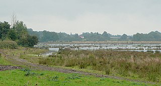
Ashleworth Ham is a 104.73-hectare (258.8-acre) biological Site of Special Scientific Interest. It is a large area of grassland on the Severn floodplain, north of Ashleworth in Gloucestershire, England. It is registered as a Site of Special Scientific Interest and was notified in 1974 and renotified in 1985. Ashleworth Ham received this designation because it is one of three sites in the Severn Vale where migratory waterfowl winter.

Upton Warren is a village and civil parish in the Wychavon district, in Worcestershire, England. The village is situated just off the A38 road between Bromsgrove and Droitwich Spa, and on the River Salwarpe. In the 2001 census, the parish, which also contains the small hamlet of Cooksey Green, had a population of 291.

Ham Wall is an English wetland National Nature Reserve (NNR) 4 kilometres (2.5 mi) west of Glastonbury on the Somerset Levels. It is managed by the Royal Society for the Protection of Birds (RSPB). Since the last Ice Age, decomposing plants in the marshes of the Brue valley in Somerset have accumulated as deep layers of peat that were commercially exploited on a large scale in the twentieth century. Consumer demand eventually declined, and in 1994 the landowners, Fisons, gave their old workings to what is now Natural England, who passed the management of the 260 hectares Ham Wall section to the RSPB.

Alvecote Pools is a Site of Special Scientific Interest (SSSI) and nature reserve situated alongside the River Anker, adjacent to the hamlet of Alvecote on the border of Warwickshire and Staffordshire in England. The majority of the reserve lies in the former county. Consisting of two discrete areas, Pooley Fields and Alvecote Meadows, the site covers 128 ha in total and is the largest SSSI in Warwickshire. First notified in 1955, the site has been owned by the Warwickshire Wildlife Trust since 1997.

Decoy Pit, Pools and Woods is a 17.7-hectare (44-acre) biological Site of Special Scientific Interest south of Aldermaston in Berkshire. An area of 8 hectares is a nature reserve called Decoy Heath, which is managed by the Berkshire, Buckinghamshire and Oxfordshire Wildlife Trust.

The Idle Valley Nature Reserve, also known as Lound Gravel Pits or Sutton and Lound Gravel Pits, is a wetland Site of Special Scientific Interest (SSSI) situated north-west of the town of Retford in the Bassetlaw district of north Nottinghamshire. The nature reserve is situated along the western bank of the River Idle and east of the villages of Sutton cum Lound and Lound. The nature reserve is managed by the Nottinghamshire Wildlife Trust.

Barnby Broad and Marshes is a Site of Special Scientific Interest (SSSI) in the Waveney district of the English county of Suffolk. The site is 189.6 hectares in size. It is in the parishes of North Cove and Barnby, located between Beccles and Lowestoft in the north of the county. The site is bordered on its southern edge by the East Suffolk railway line and to the north by the River Waveney. It is a Special Area of Conservation, a Special Protection Area under the EC Birds Directive, and a Ramsar internationally important wetland site. There are two Suffolk Wildlife Trust nature reserves in the site, Castle Marshes and North Cove.

Dingle Marshes is a 93-hectare (230-acre) wildlife reserve on the North Sea coast of the English county of Suffolk. The reserve is located between Dunwich and Walberswick, approximately 4 miles (6.4 km) south-west of Southwold. The marshes make up part of the Suffolk Coast National Nature Reserve along with reserves at Walberswick and Hen Reedbeds. They are owned jointly by the RSPB and Suffolk Wildlife Trust and are managed by these two organisations and Natural England. The site is in the Dunwich Heaths and Marshes Nature Conservation Review site, Grade I, the Minsmere-Walberswick Ramsar internationally important wetland site, the Minsmere to Walberswick Heaths and Marshes Special Area of Conservation, and the Minsmere-Walberswick Special Protection Area under the European Union Directive on the Conservation of Wild Birds.

Cley Marshes is a 176-hectare (430-acre) nature reserve on the North Sea coast of England just outside the village of Cley next the Sea, Norfolk. A reserve since 1926, it is the oldest of the reserves belonging to the Norfolk Wildlife Trust (NWT), which is itself the oldest county Wildlife Trust in the United Kingdom. Cley Marshes protects an area of reed beds, freshwater marsh, pools and wet meadows and is part of the North Norfolk Coast Site of Special Scientific Interest (SSSI), Special Area of Conservation (SAC), Special Protection Area (SPA), and Ramsar Site due to the large numbers of birds it attracts.

Suffolk Coast National Nature Reserve is a wildlife reserve on the North Sea coast of the English county of Suffolk. It is located around the village of Walberswick to the south of the town of Southwold. The reserve was designated in 2003, combining the existing Walberswick National Nature Reserve with reserves at Dingle Marshes and Hen Reedbeds to create a 1,340 hectares reserve.
The Avalon Marshes Partnership is a group of conservation organisations working together in the Somerset Levels. The members are Natural England,, the Royal Society for the Protection of Birds (RSPB), the Somerset Wildlife Trust the Hawk and Owl Trust, Historic England, South West Heritage Trust and the Environment Agency. Between 2012 and 2016 the scheme was supported by a Heritage Lottery Fund grant of £1,772,500 with additional investment of £920,080 from other sources. The Avalon Marshes Centre, run by Natural England, is near the Ham Wall reserve. The network of reserves and private land managed for conservation in the Avalon marshes means that wetland management can be carried out on a landscape scale.

Wilden Marsh is a nature reserve of the Worcestershire Wildlife Trust. It is situated between Kidderminster and Stourport-on-Severn, in Worcestershire, England, immediately east of the Staffordshire and Worcestershire Canal, and alongside the River Stour. The reserve is a Site of Special Scientific Interest.
Radford Meadows is a nature reserve of the Staffordshire Wildlife Trust, on the southern edge of Stafford, in Staffordshire, England. The reserve is a floodplain situated between the River Penk to the west, and the Staffordshire and Worcestershire Canal.


