FidoNet is a worldwide computer network that is used for communication between bulletin board systems (BBSes). It uses a store-and-forward system to exchange private (email) and public (forum) messages between the BBSes in the network, as well as other files and protocols in some cases.
Grid computing is the use of widely distributed computer resources to reach a common goal. A computing grid can be thought of as a distributed system with non-interactive workloads that involve many files. Grid computing is distinguished from conventional high-performance computing systems such as cluster computing in that grid computers have each node set to perform a different task/application. Grid computers also tend to be more heterogeneous and geographically dispersed than cluster computers. Although a single grid can be dedicated to a particular application, commonly a grid is used for a variety of purposes. Grids are often constructed with general-purpose grid middleware software libraries. Grid sizes can be quite large.
An information society is a society where the usage, creation, distribution, manipulation and integration of information is a significant activity. Its main drivers are information and communication technologies, which have resulted in rapid growth of a variety of forms of information. Proponents of this theory posit that these technologies are impacting most important forms of social organization, including education, economy, health, government, warfare, and levels of democracy. The people who are able to partake in this form of society are sometimes called either computer users or even digital citizens, defined by K. Mossberger as “Those who use the Internet regularly and effectively”. This is one of many dozen internet terms that have been identified to suggest that humans are entering a new and different phase of society.

The term built environment refers to human-made conditions and is often used in architecture, landscape architecture, urban planning, public health, sociology, and anthropology, among others. These curated spaces provide the setting for human activity and were created to fulfill human desires and needs. The term can refer to a plethora of components including the traditionally associated buildings, cities, public infrastructure, transportation, open space, as well as more conceptual components like farmlands, dammed rivers, wildlife management, and even domesticated animals.
An anonymous P2P communication system is a peer-to-peer distributed application in which the nodes, which are used to share resources, or participants are anonymous or pseudonymous. Anonymity of participants is usually achieved by special routing overlay networks that hide the physical location of each node from other participants.
The Resource Reservation Protocol (RSVP) is a transport layer protocol designed to reserve resources across a network using the integrated services model. RSVP operates over an IPv4 or IPv6 and provides receiver-initiated setup of resource reservations for multicast or unicast data flows. It does not transport application data but is similar to a control protocol, like Internet Control Message Protocol (ICMP) or Internet Group Management Protocol (IGMP). RSVP is described in RFC 2205.
The language of thought hypothesis (LOTH), sometimes known as thought ordered mental expression (TOME), is a view in linguistics, philosophy of mind and cognitive science, forwarded by American philosopher Jerry Fodor. It describes the nature of thought as possessing "language-like" or compositional structure. On this view, simple concepts combine in systematic ways to build thoughts. In its most basic form, the theory states that thought, like language, has syntax.

The multiple nuclei model is an economical model created by Chauncy Harris and Edward Ullman in the 1945 article "The Nature of Cities".
A transport network, or transportation network, is a network or graph in geographic space, describing an infrastructure that permits and constrains movement or flow. Examples include but are not limited to road networks, railways, air routes, pipelines, aqueducts, and power lines. The digital representation of these networks, and the methods for their analysis, is a core part of spatial analysis, geographic information systems, public utilities, and transport engineering. Network analysis is an application of the theories and algorithms of graph theory and is a form of proximity analysis.
Cognitive semantics is part of the cognitive linguistics movement. Semantics is the study of linguistic meaning. Cognitive semantics holds that language is part of a more general human cognitive ability, and can therefore only describe the world as people conceive of it. It is implicit that different linguistic communities conceive of simple things and processes in the world differently, not necessarily some difference between a person's conceptual world and the real world.
The commons is the cultural and natural resources accessible to all members of a society, including natural materials such as air, water, and a habitable Earth. These resources are held in common even when owned privately or publicly. Commons can also be understood as natural resources that groups of people manage for individual and collective benefit. Characteristically, this involves a variety of informal norms and values employed for a governance mechanism. Commons can also be defined as a social practice of governing a resource not by state or market but by a community of users that self-governs the resource through institutions that it creates.
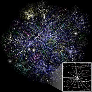
A computer network is a set of computers sharing resources located on or provided by network nodes. Computers use common communication protocols over digital interconnections to communicate with each other. These interconnections are made up of telecommunication network technologies based on physically wired, optical, and wireless radio-frequency methods that may be arranged in a variety of network topologies.
A business cluster is a geographic concentration of interconnected businesses, suppliers, and associated institutions in a particular field. Clusters are considered to increase the productivity with which companies can compete, nationally and globally. Accounting is a part of the business cluster. In urban studies, the term agglomeration is used. Clusters are also important aspects of strategic management.
A wireless ad hoc network (WANET) or mobile ad hoc network (MANET) is a decentralized type of wireless network. The network is ad hoc because it does not rely on a pre-existing infrastructure, such as routers or wireless access points. Instead, each node participates in routing by forwarding data for other nodes. The determination of which nodes forward data is made dynamically on the basis of network connectivity and the routing algorithm in use.

Nikos Angelos Salingaros is a mathematician and polymath known for his work on urban theory, architectural theory, complexity theory, and design philosophy. He has been a close collaborator of the architect Christopher Alexander, with whom Salingaros shares a harsh critical analysis of conventional modern architecture. Like Alexander, Salingaros has proposed an alternative theoretical approach to architecture and urbanism that is more adaptive to human needs and aspirations, and that combines rigorous scientific analysis with deep intuitive experience.
Spatial inequality refers to the unequal distribution of income and resources across geographical regions. Attributable to local differences in infrastructure, geographical features and economies of agglomeration, such inequality remains central to public policy discussions regarding economic inequality more broadly.
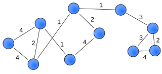
A weighted network is a network where the ties among nodes have weights assigned to them. A network is a system whose elements are somehow connected. The elements of a system are represented as nodes and the connections among interacting elements are known as ties, edges, arcs, or links. The nodes might be neurons, individuals, groups, organisations, airports, or even countries, whereas ties can take the form of friendship, communication, collaboration, alliance, flow, or trade, to name a few.
Structural holes is a concept from social network research, originally developed by Ronald Stuart Burt. A structural hole is understood as a gap between two individuals who have complementary sources to information. The study of structural holes spans the fields of sociology, economics, and computer science. Burt introduced this concept in an attempt to explain the origin of differences in social capital. Burt’s theory suggests that individuals hold certain positional advantages/disadvantages from how they are embedded in neighborhoods or other social structures.
A distributed ledger is the consensus of replicated, shared, and synchronized digital data that is geographically spread (distributed) across many sites, countries, or institutions. In contrast to a centralized database, a distributed ledger does not require a central administrator, and consequently does not have a single (central) point-of-failure.
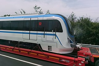
Taizhou Rail Transit, are two systems of commuter railway, one of which effectively works as a metro system in Taizhou, Zhejiang province, China. The system is operated by Taizhou Rail Transit Construction and Development Co., Ltd. In the near term, two lines, S1 and S2, are planned; in the long term, lines S3 and S4 are planned. The first phase of the plan was approved by the National Development and Reform Commission of the People's Republic of China in December 2014, and approved by the Zhejiang Provincial Development and Reform Commission in September 2016. Construction of Line S1 started in November 2016 and lasted until opening in December 2022.