
Ice cream is a sweetened frozen food typically eaten as a snack or dessert. It may be made from milk or cream and is flavoured with a sweetener, either sugar or an alternative, and a spice, such as cocoa or vanilla, or with fruit such as strawberries or peaches. It can also be made by whisking a flavored cream base and liquid nitrogen together. Food coloring is sometimes added, in addition to stabilizers. The mixture is cooled below the freezing point of water and stirred to incorporate air spaces and to prevent detectable ice crystals from forming. The result is a smooth, semi-solid foam that is solid at very low temperatures. It becomes more malleable as its temperature increases.

Adlington is a village and civil parish in Lancashire, England, near the West Pennine Moors and approximately three miles south of Chorley. It became a separate parish in 1842 then grew into a township around the textile and coal mining industries until these closed in the 1960s. It had a population of 5,270 at the 2001 census, but in the last decade this has risen by over 2,000 more people to 7,326. The measured population at the 2011 Census was 6,010. The Leeds and Liverpool Canal runs through the village and is host to White Bear Marina which is the largest marina on the Leeds and Liverpool Canal.
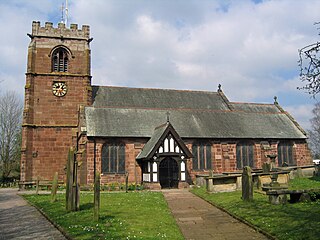
Tattenhall is a village and former civil parish, now in the parish of Tattenhall and District, 8 miles (13 km) south-east of Chester, in the unitary authority of Cheshire West and Chester and the ceremonial county of Cheshire, England. In the 2001 census, the population was recorded as 1,986, increasing to 2,079 by the 2011 census. The civil parish was abolished in 2015 to form Tattenhall and District.

South Ribble is a borough in the county of Lancashire, England. Its council is based in Leyland. The population, at the 2011 Census, was 109,057. Notable towns and villages include Walton le Dale, Bamber Bridge, Leyland and Penwortham. It is wedged geographically between the towns of Blackburn, Lytham St Annes and Chorley and the city of Preston.

Hyndburn is a local government district with borough status in Lancashire, England. Its council is based in Accrington. The borough, which takes its name from the River Hyndburn, had a population of 80,734 at the 2011 Census.

The City of Lancaster is a local government district of Lancashire, England, with the status of a city and non-metropolitan district. It is named after its largest settlement, Lancaster, but covers a far larger area, which includes the towns of Morecambe, Heysham, and Carnforth, as well as outlying villages, farms, rural hinterland and a section of the Yorkshire Dales National Park. The district has a population of 146,038 (mid-2019 est.), and an area of 222.5 square miles (576.2 km2).

The Borough of Chorley is a local government district with borough status in Lancashire, England. The population of the Borough at the 2011 census was 107,155. It is named after its largest settlement, the town of Chorley.

Clayton-le-Moors is an industrial town, located two miles north of Accrington in the borough of Hyndburn in the county of Lancashire, England. It is usually referred to locally as simply 'Clayton'. The town has a population of 8,522 according to the 2011 census.
Bolton-le-Sands is a large village and civil parish of the City of Lancaster in Lancashire, England. The parish had a population of 4,098 recorded in the 2001 census, increasing to 4,127 at the 2011 Census.

Walton-le-Dale is a large village in the borough of South Ribble, in Lancashire, England. It lies on the south bank of the River Ribble, opposite the city of Preston, adjacent to Bamber Bridge. The population of the South Ribble Ward at the 2011 census was 3,792. To the west of Walton-le-Dale is the residential area of Walton Park.

Queensbury is a large village in the metropolitan borough of Bradford, West Yorkshire, England. Perched on a high vantage point above Halifax, Clayton and Thornton and overlooking Bradford itself, Queensbury is one of the highest parishes in England, with fine views beyond the West Yorkshire conurbation to the hills of Brontë Country and the Yorkshire Dales to the north and north west. It had a population of 8,718 in 2001 which increased to 16,273 in the 2011 Census.

Clayton-le-Woods is a large village and civil parish of the Borough of Chorley, in Lancashire, England. According to the census of 2001, it has a population of 14,528. At the 2011 census the population of Cuerden civil parish was included within Clayton-le-Woods, giving a total of 14,532.

Altham is a village and civil parish in the Borough of Hyndburn, in Lancashire, England. It is the only parish in the borough – the remainder is an unparished area. The village is 4.3 miles (6.9 km) west of Burnley, 2.9 miles (4.7 km) north of Accrington, and 2 miles (3.2 km) north-east of Clayton-le-Moors, and is on the A678 Blackburn to Burnley road.

Bickerstaffe is a village and civil parish in the West Lancashire district of Lancashire, England. According to the 2001 Census the population of the civil parish was 1,196, reducing to 1,180 at the 2011 census, although the population of the electoral ward, which includes Lathom South, was slightly greater at 2,013, reducing to 1,988 at the 2011 census. The village is near junction 3 of the M58 motorway, and is about four miles west of Skelmersdale.

Church is a large village in Hyndburn, Lancashire, England, situated a mile west of Accrington. The village has a population of 5,186 at the 2011 Census, an increase from 3,990 according to the 2001 census.

Much Hoole is a village and civil parish in the borough of South Ribble, Lancashire, England. The parish of Much Hoole had a population of 1,851 at the time of the 2001 census, increasing to 1,997 at the 2011 Census.

Newburgh is a rural village and civil parish in Lancashire, England, 3 miles (5 km) from Skelmersdale and 5 miles (8 km) from Ormskirk. Its population in 2011 was 1,056.

Salesbury is a village and civil parish in Ribble Valley, located centrally in the county of Lancashire, England. The B6245 road runs straight through the village providing transport links to towns such as Blackburn, Preston and Burnley. Salesbury lies less than 5 miles north of Blackburn and approximately 2 miles south of the River Ribble.

Bacon ice cream is an ice cream generally created by adding bacon to egg custard and freezing the mixture. The concept of bacon ice cream originated in a 1973 sketch on the British comedy series The Two Ronnies as a joke; it was eventually created for April Fools' Day by a New York ice cream parlour in 1982. In the 2000s, the English chef Heston Blumenthal experimented with ice cream, making a custard similar to scrambled eggs and adding bacon to create one of his signature dishes. It now appears on dessert menus in other restaurants.
Clayton-le-Dale is a civil parish in Ribble Valley, Lancashire, England. It contains five listed buildings that are recorded in the National Heritage List for England. Of these, one is at Grade II*, the middle grade, and the others are at Grade II, the lowest grade. The parish contains the village of Clayton-le-Dale and surrounding countryside. The listed buildings consist of houses, a former toll house, and a bridge.

