
Mars Global Surveyor (MGS) was an American robotic space probe developed by NASA's Jet Propulsion Laboratory and launched November 1996. MGS was a global mapping mission that examined the entire planet, from the ionosphere down through the atmosphere to the surface. As part of the larger Mars Exploration Program, Mars Global Surveyor performed atmospheric monitoring for sister orbiters during aerobraking, and helped Mars rovers and lander missions by identifying potential landing sites and relaying surface telemetry.

Utopia Planitia is a large plain within Utopia, the largest recognized impact basin on Mars and in the Solar System with an estimated diameter of 3,300 km (2,100 mi). It is the Martian region where the Viking 2 lander touched down and began exploring on September 3, 1976, and the Zhurong rover touched down on May 14, 2021, as a part of the Tianwen-1 mission. It is located at the antipode of Argyre Planitia, centered at 46.7°N 117.5°E. It is also in the Casius quadrangle, Amenthes quadrangle, and the Cebrenia quadrangle of Mars.

The Memnonia quadrangle is one of a series of 30 quadrangle maps of Mars used by the United States Geological Survey (USGS) Astrogeology Research Program. The Memnonia quadrangle is also referred to as MC-16.
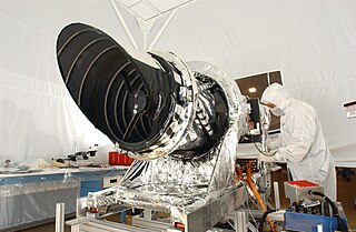
High Resolution Imaging Science Experiment is a camera on board the Mars Reconnaissance Orbiter which has been orbiting and studying Mars since 2006. The 65 kg (143 lb), US$40 million instrument was built under the direction of the University of Arizona's Lunar and Planetary Laboratory by Ball Aerospace & Technologies Corp. It consists of a 0.5 m (19.7 in) aperture reflecting telescope, the largest so far of any deep space mission, which allows it to take pictures of Mars with resolutions of 0.3 m/pixel, resolving objects below a meter across.

Cydonia is a region on the planet Mars that has attracted both scientific and popular interest. The name originally referred to the albedo feature that was visible from earthbound telescopes. The area borders the plains of Acidalia Planitia and the highlands of Arabia Terra. The region includes the named features Cydonia Mensae, an area of flat-topped mesa-like features; Cydonia Colles, a region of small hills or knobs; and Cydonia Labyrinthus, a complex of intersecting valleys. As with other albedo features on Mars, the name Cydonia was drawn from classical antiquity, in this case from Kydonia, a historic polis on the island of Crete. Cydonia contains the "Face on Mars", located about halfway between the craters Arandas and Bamberg.

Eberswalde, formerly known as Holden NE, is a partially buried impact crater in Margaritifer Terra, Mars. Eberswalde crater lies just to the north of Holden, a large crater that may have been a lake. The 65.3-km-diameter crater, centered at 24°S, 33°W, is named after the German town of the same name, in accordance with the International Astronomical Union's rules for planetary nomenclature. It was one of the final four proposed landing sites for the Mars rover Mars Science Laboratory mission. This extraterrestrial geological feature lies situated within the Margaritifer Sinus quadrangle (MC-19) region of Mars. Although not chosen, it was considered a potential landing site for the Mars 2020 Perseverance rover, and in the second Mars 2020 Landing Site Workshop it survived the cut and was among the top eight sites still in the running.

The Noachis quadrangle is one of a series of 30 quadrangle maps of Mars used by the United States Geological Survey (USGS) Astrogeology Research Program. The Noachis quadrangle is also referred to as MC-27.

The Diacria quadrangle is one of a series of 30 quadrangle maps of Mars used by the United States Geological Survey (USGS) Astrogeology Research Program. The quadrangle is located in the northwestern portion of Mars’ western hemisphere and covers 180° to 240° east longitude and 30° to 65° north latitude. The quadrangle uses a Lambert conformal conic projection at a nominal scale of 1:5,000,000 (1:5M). The Diacria quadrangle is also referred to as MC-2. The Diacria quadrangle covers parts of Arcadia Planitia and Amazonis Planitia.

The Amazonis quadrangle is one of a series of 30 quadrangle maps of Mars used by the United States Geological Survey (USGS) Astrogeology Research Program. The Amazonis quadrangle is also referred to as MC-8.

The Tharsis quadrangle is one of a series of 30 quadrangle maps of Mars used by the United States Geological Survey (USGS) Astrogeology Research Program. The Tharsis quadrangle is also referred to as MC-9 . The name Tharsis refers to a land mentioned in the Bible. It may be at the location of the old town of Tartessus at the mouth of Guadalquivir.

The Lunae Palus quadrangle is one of a series of 30 quadrangle maps of Mars used by the United States Geological Survey (USGS) Astrogeology Research Program. The quadrangle is also referred to as MC-10. Lunae Planum and parts of Xanthe Terra and Chryse Planitia are found in the Lunae Palus quadrangle. The Lunae Palus quadrangle contains many ancient river valleys.
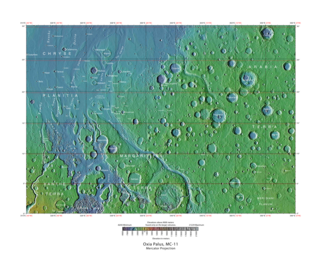
The Oxia Palus quadrangle is one of a series of 30 quadrangle maps of Mars used by the United States Geological Survey (USGS) Astrogeology Research Program. The Oxia Palus quadrangle is also referred to as MC-11.
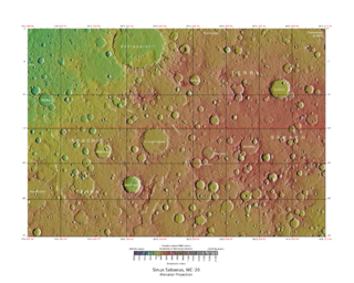
The Sinus Sabaeus quadrangle is one of a series of 30 quadrangle maps of Mars used by the United States Geological Survey (USGS) Astrogeology Research Program. It is also referred to as MC-20 . The Sinus Sabaeus quadrangle covers the area from 315° to 360° west longitude and 0° to 30° degrees south latitude on Mars. It contains Schiaparelli, a large, easily visible crater that sits close to the equator. The Sinus Sabaeus quadrangle contains parts of Noachis Terra and Terra Sabaea.

The Margaritifer Sinus quadrangle is one of a series of 30 quadrangle maps of Mars used by the United States Geological Survey (USGS) Astrogeology Research Program. The Margaritifer Sinus quadrangle is also referred to as MC-19. The Margaritifer Sinus quadrangle covers the area from 0° to 45° west longitude and 0° to 30° south latitude on Mars. Margaritifer Sinus quadrangle contains Margaritifer Terra and parts of Xanthe Terra, Noachis Terra, Arabia Terra, and Meridiani Planum.

The Mare Australe quadrangle is one of a series of 30 quadrangle maps of Mars used by the United States Geological Survey (USGS) Astrogeology Research Program. The Mare Australe quadrangle is also referred to as MC-30. The quadrangle covers all the area of Mars south of 65°, including the South polar ice cap, and its surrounding area. The quadrangle's name derives from an older name for a feature that is now called Planum Australe, a large plain surrounding the polar cap. The Mars polar lander crash landed in this region.

Dark slope streaks are narrow, avalanche-like features common on dust-covered slopes in the equatorial regions of Mars. They form in relatively steep terrain, such as along escarpments and crater walls. Although first recognized in Viking Orbiter images from the late 1970s, dark slope streaks were not studied in detail until higher-resolution images from the Mars Global Surveyor (MGS) and Mars Reconnaissance Orbiter (MRO) spacecraft became available in the late 1990s and 2000s.
Penticton is an impact crater in the Hellas quadrangle of Mars, located at 38.35° south latitude and 263.35° west longitude. Penticton is on the eastern rim of the Hellas impact crater. It is 8 kilometers in diameter and was named after Penticton, a Town in British Columbia, Canada, nearby the little town of Okanagan Falls where is located the Dominion Radio Astrophysical Observatory. Images with HiRISE show gullies which were once thought to be caused by flowing water.
Fretted terrain is a type of surface feature common to certain areas of Mars and was discovered in Mariner 9 images. It lies between two different types of terrain. The surface of Mars can be divided into two parts: low, young, uncratered plains that cover most of the northern hemisphere, and high-standing, old, heavily cratered areas that cover the southern and a small part of the northern hemisphere. Between these two zones is a region called the Martian dichotomy and parts of it contain fretted terrain. This terrain contains a complicated mix of cliffs, mesas, buttes, and straight-walled and sinuous canyons. It contains smooth, flat lowlands along with steep cliffs. The scarps or cliffs are usually 1 to 2 km high. Channels in the area have wide, flat floors and steep walls. Fretted terrain shows up in northern Arabia, between latitudes 30°N and 50°N and longitudes 270°W and 360°W, and in Aeolis Mensae, between 10 N and 10 S latitude and 240 W and 210 W longitude. Two good examples of fretted terrain are Deuteronilus Mensae and Protonilus Mensae.
Asimov Crater is an impact crater in the Noachis quadrangle of Mars, located at 47.0° S and 355.05° W. It is 84.0 km (52.2 mi) in diameter and was named after Isaac Asimov (1920–1992), an American biochemist and writer. The name was officially adopted on May 4, 2009.
To date, interplanetary spacecraft have provided abundant evidence of water on Mars, dating back to the Mariner 9 mission, which arrived at Mars in 1971. This article provides a mission by mission breakdown of the discoveries they have made. For a more comprehensive description of evidence for water on Mars today, and the history of water on that planet, see Water on Mars.