
Brunei is a country in Southeast Asia, bordering the South China Sea and East Malaysia. Its geographical coordinates are 4°30′N114°40′E. The country is small with a total size of 5,765 km2 (2,226 sq mi). It is larger in size than Trinidad and Tobago. It is close to vital sea lanes through the South China Sea linking the Indian and Pacific Oceans. The country has two parts physically separated by Malaysia, making it almost an enclave within Malaysia.

Djibouti is a country in the Horn of Africa. It is bordered by Eritrea in the north, Ethiopia in the west and south, and Somalia in the southeast. To the east is its coastline on the Red Sea and the Gulf of Aden. Rainfall is sparse, and most of the territory has a semi-arid to arid environment. Lake Assal is a saline lake which lies 155 m (509 ft) below sea level, making it the lowest point on land in Africa and the third-lowest point on Earth after the Sea of Galilee and the Dead Sea. Djibouti has the fifth smallest population in Africa. Djibouti's major settlements include the capital Djibouti City, the port towns of Tadjoura and Obock, and the southern cities of Ali Sabieh and Dikhil. It is the forty-six country by area in Africa and 147st largest country in the world by land area, covering a total of 23,200 km2 (9,000 sq mi), of which 23,180 km2 (8,950 sq mi) is land and 20 km2 (7.7 sq mi) is water.
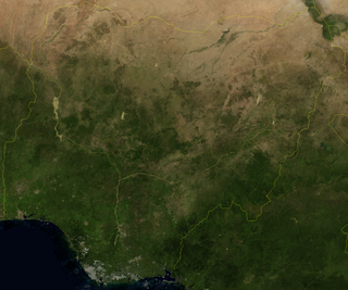
Nigeria is a country in West Africa. It shares land borders with the Republic of Benin to the west, Chad and Cameroon to the east, and Niger to the north. Its coast lies on the Gulf of Guinea in the south and it borders Lake Chad to the northeast. Notable geographical features in Nigeria include the Adamawa Plateau, Mambilla Plateau, Jos Plateau, Obudu Plateau, the Niger River, Benue River, and Niger Delta.

The Intertropical Convergence Zone, known by sailors as the doldrums or the calms because of its monotonous windless weather, is the area where the northeast and the southeast trade winds converge. It encircles Earth near the thermal equator though its specific position varies seasonally. When it lies near the geographic Equator, it is called the near-equatorial trough. Where the ITCZ is drawn into and merges with a monsoonal circulation, it is sometimes referred to as a monsoon trough.
The South Pacific Convergence Zone (SPCZ), a reverse-oriented monsoon trough, is a band of low-level convergence, cloudiness and precipitation extending from the Western Pacific Warm Pool at the maritime continent south-eastwards towards French Polynesia and as far as the Cook Islands. The SPCZ is a portion of the Intertropical Convergence Zone (ITCZ) which lies in a band extending east–west near the Equator but can be more extratropical in nature, especially east of the International Date Line. It is considered the largest and most important piece of the ITCZ, and has the least dependence upon heating from a nearby landmass during the summer than any other portion of the monsoon trough. The SPCZ can affect the precipitation on Polynesian islands in the southwest Pacific Ocean, so it is important to understand how the SPCZ behaves with large-scale, global climate phenomenon, such as the ITCZ, El Niño–Southern Oscillation, and the Interdecadal Pacific oscillation (IPO), a portion of the Pacific decadal oscillation.
In West Africa, the forest zone refers to the southern part of the region once covered by tropical rainforest. Sometimes this region is referred to as Guinea to distinguish it from the grassland-covered Sudan, drier Sahel and per-arid Sahara. It is made-up of vegetation having mainly trees and consist of the following local biotic communities: -mangrove swamp forest -tropical rain forest.

The Awash is a major river of Ethiopia. Its course is entirely contained within the boundaries of Ethiopia and empties into a chain of interconnected lakes that begin with Lake Gargori and end with Lake Abbe on the border with Djibouti, some 100 kilometres from the head of the Gulf of Tadjoura. It is the principal stream of an endorheic drainage basin covering parts of the Amhara, Oromia and Somali Regions, as well as the southern half of the Afar Region.

The Ethiopian Highlands is a rugged mass of mountains in Ethiopia in Northeast Africa. It forms the largest continuous area of its elevation in the continent, with little of its surface falling below 1,500 m (4,900 ft), while the summits reach heights of up to 4,550 m (14,930 ft). It is sometimes called the "Roof of Northeastern Africa" due to its height and large area. It is the only country in the region with such a high elevated surface. This elevated surface is bisected diagonally by the Great East African Rift System which extends from Syria to Mozambique across the East African Lakes. Most of the Ethiopian Highlands are part of central and northern Ethiopia, and its northernmost portion reaches into Eritrea.

A convergence zone in meteorology is a region in the atmosphere where two prevailing flows meet and interact, usually resulting in distinctive weather conditions. This causes a mass accumulation that eventually leads to a vertical movement and to the formation of clouds and precipitation. Large-scale convergence, called synoptic-scale convergence, is associated with weather systems such as baroclinic troughs, low-pressure areas, and cyclones. The large-scale convergence zone formed over the equator, the Intertropical Convergence Zone, has condensed and intensified as a result of the global increase in temperature. Small-scale convergence will give phenomena from isolated cumulus clouds to large areas of thunderstorms.

Turbo is a port city in Antioquia Department, Colombia. Part of the Urabá Antioquia sub-region, it is located on the coast of Gulf of Urabá, 340 km north of Medellín. This port city is the capital of the Urabá region of Antioquia. The place where Turbo is today was known as Pisisí, but by 1741 people were already talking about Turbo. By a decree on May 11, 1839, the central government spent one thousand pesos for military service barracks in Turbo. In 1840, the republican president assigned one thousand fanegas of uncultivated lands for the new population. It was established as a municipality in 1847.

The climate of Zambia in Central and Southern Africa is definitely tropical modified by altitude (elevation). In the Köppen climate classification, most of the country is classified as humid subtropical or tropical wet and dry, with small patches of semi-arid steppe climate in the south-west.

A tropical rainforest climate or equatorial climate is a tropical climate sub-type usually found within 10 to 15 degrees latitude of the equator. There are some other areas at higher latitudes, such as the coast of southeast Florida, United States, and Okinawa, Japan that fall into the tropical rainforest climate category. They experience high mean annual temperatures, small temperature ranges, and rain that falls throughout the year. Regions with this climate are typically designated Af by the Köppen climate classification. A tropical rainforest climate is typically hot, very humid, and wet with no dry season.
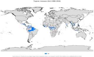
An area of tropical monsoon climate is a tropical climate sub-type that corresponds to the Köppen climate classification category Am. Tropical monsoon climates have monthly mean temperatures above 18 °C (64 °F) in every month of the year and a dry season. The tropical monsoon climate is the intermediate climate between the wet Af and the drier Aw.

Earth rainfall climatology Is the study of rainfall, a sub-field of meteorology. Formally, a wider study includes water falling as ice crystals, i.e. hail, sleet, snow. The aim of rainfall climatology is to measure, understand and predict rain distribution across different regions of planet Earth, a factor of air pressure, humidity, topography, cloud type and raindrop size, via direct measurement and remote sensing data acquisition. Current technologies accurately predict rainfall 3–4 days in advance using numerical weather prediction. Geostationary orbiting satellites gather IR and visual wavelength data to measure realtime localised rainfall by estimating cloud albedo, water content, and the corresponding probability of rain.
There are a number of explanations of the asymmetry of the Intertropical Convergence Zone (ITCZ), known by sailors as the Doldrums.

Seasonal tropical forest, also known as moist deciduous, semi-evergreen seasonal, tropical mixed or monsoon forest, typically contains a range of tree species: only some of which drop some or all of their leaves during the dry season. This tropical forest is classified under the Walter system as (i) tropical climate with high overall rainfall and (ii) having a very distinct wet season with dry season. These forests represent a range of habitats influenced by monsoon (Am) or tropical wet savannah (Aw/As) climates. Drier forests in the Aw climate zone are typically deciduous and placed in the Tropical dry forest biome: with further transitional zones (ecotones) of savannah woodland then tropical and subtropical grasslands, savannas, and shrublands.
Climate change in Ethiopia is affecting the people in Ethiopia due to increased floods, heat waves and infectious diseases. In the Awash basin in central Ethiopia floods and droughts are common. Agriculture in the basin is mainly rainfed. This applies to around 98% of total cropland as of 2012. So changes in rainfall patterns due to climate change will reduce economic activities in the basin. Rainfall shocks have a direct impact on agriculture. A rainfall decrease in the Awash basin could lead to a 5% decline in the basin's overall GDP. The agricultural GDP could even drop by as much as 10%.

The highland temperate climates are a temperate climate sub-type, although located in tropical zone, isothermal and with characteristics different from others temperate climates like oceanic or mediterranean where they are often are included without proper differentiation.

Ethiopian seasons consist of four phases: Tsedey (Spring) (September–November), Bega (Summer) (December–February), Belg (Fall) (March–May) and Kiremt (Winter) (June–August). The most dry and cold season is Bega, while Kiremt is extremely rainy and when 85% to 95% of food crops are produced
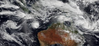
The Australian monsoon (AUM), also known as the Australian summer monsoon (ASM), and the Australian-Indonesian monsoon (AIM), is a monsoon system that increases thunderstorms and rainfall over many areas of Indonesia and northern Australia, from the far northern tropics of the region to the semi-arid zone of Australia, typically between November and mid-March, which is the wet season of many parts of northern Australia and Indonesia.
