
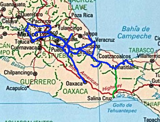
Veracruz, formally Veracruz de Ignacio de la Llave, officially the Estado Libre y Soberano de Veracruz de Ignacio de la Llave, is one of the 31 states which, along with Mexico City, comprise the 32 Federal Entities of Mexico. Located in eastern Mexico, Veracruz is bordered by seven states, which are Tamaulipas, San Luis Potosí, Hidalgo, Puebla, Oaxaca, Chiapas, and Tabasco. Veracruz is divided into 212 municipalities, and its capital city is Xalapa-Enríquez.

New Spain, officially the Viceroyalty of New Spain, or Kingdom of New Spain, was an integral territorial entity of the Spanish Empire, established by Habsburg Spain during the Spanish conquest of the Americas and having its capital in Mexico City. Its jurisdiction comprised a large area of the southern and western portions of North America, mainly what is now Mexico and the Southwestern United States, but also California, Florida and Louisiana; Central America, the Caribbean, and northern parts of South America; several Pacific archipelagos, most notably the Philippines and Guam; and numerous Asian port cities including Nagasaki and Spanish Formosa.
The Huastec or Téenek are an indigenous people of Mexico, living in the La Huasteca region including the states of Hidalgo, Veracruz, San Luis Potosí and Tamaulipas concentrated along the route of the Pánuco River and along the coast of the Gulf of Mexico.
La Antigua is a municipality in the Mexican state of Veracruz. The city of José Cardel serves as the municipal seat. La Antigua is regarded as the first real Spanish town in Mexico.

Coatzacoalcos is a major port city in the southern part of the Mexican state of Veracruz, mostly on the western side of the Coatzacoalcos River estuary, on the Bay of Campeche, on the southern Gulf of Mexico coast. The city serves as the municipal seat of the municipality of the same name. The city had a 2020 census population of 212,540, making it the third-largest city in the state after Veracruz and Xalapa. The municipality covers a surface area of 471.16 km2 (181.916 sq mi) and reported a population of 310,698 persons. The municipality population in 2015 was 319,187 a decrease of 9% over 2020.

Minatitlán is a city in the Mexican state of Veracruz. It is located in the southeastern part of the state, in the Olmeca region, to the north of the Isthmus of Tehuantepec, along the Coatzacoalcos River.

The Isthmus of Tehuantepec is an isthmus in Mexico. It represents the shortest distance between the Gulf of Mexico and the Pacific Ocean. Before the opening of the Panama Canal, it was a major overland transport route known simply as the Tehuantepec Route. The name is taken from the town of Santo Domingo Tehuantepec in the state of Oaxaca; this was derived from the Nahuatl term Tēcuāntepēc.

Tehuantepec is a city and municipality in the southeast of the Mexican state of Oaxaca. It is part of the Tehuantepec District in the west of the Istmo Region. The area was important in pre-Hispanic period as part of a trade route that connected Central America with what is now the center of Mexico. Later it became a secondary capital of the Zapotec dominion, before it was conquered by the Spanish in the early 16th century.

Cempoala or Zempoala is an important Mesoamerican archaeological site located in the Úrsulo Galván Municipality, in the state of Veracruz, Mexico. The site was inhabited mainly by Totonacs, Chinantecas and Zapotecs. It was one of the most important Totonac settlements during the postclassical Mesoamerican period and the capital of the kingdom of Totonacapan. It is located one kilometer from the shore of the Actopan River and six kilometres from the coast.
The Ferrocarril del Sureste, commonly known by the syllabic abbreviation Ferrosur, is a railway that serves the southeastern regions of Mexico. The company was formed in 1998 following the privatization of Mexico's railways. Ferrosur won the concession to operate the southeastern railway. This includes the line between Mexico City and Mexico's busiest Gulf of Mexico/Atlantic Ocean port at Veracruz. Grupo México has owned the company since 2005 and there are long-delayed plans to merge it with the company's other railway, Ferromex.
The Ferrocarril del Istmo de Tehuantepec(Ferrocarril del Istmo de Tehuantepec, S.A. de C.V.), also known as Ferrocarril Transístmico or simply Ferroistmo, is part of the Interoceanic Corridor of the Isthmus of Tehuantepec, owned by the Mexican government, that crosses the Isthmus of Tehuantepec between Puerto Mexico, Veracruz, and Salina Cruz, Oaxaca. It is leased to Ferrocarril del Sureste FERROSUR.
Hidalgotitlán is a town in the Mexican state of Veracruz, with a population of near 18,000 in 2000. Its name derives from two words: one Spanish and the other indigenous. The first part is the family name Hidalgo, and the second part is -tlan, a Nahuatl suffix that means "place".

The Sierra Madre de Oaxaca is a mountain range in southern Mexico. It is primarily in the state of Oaxaca, and extends north into the states of Puebla and Veracruz.

The Tehuantepec River is a river in Oaxaca, Mexico. The Tehuantepec flows into the Gulf of Tehuantepec on the Pacific Ocean coast of the Isthmus of Tehuantepec. The mountainous terrain of the region it occupies allows for no navigable rivers; instead, there are a large number of smaller ones, which often change name from area to area. The continental divide passes through the state, meaning there is drainage toward both the Gulf of Mexico and the Pacific. Most of the drainage toward the Gulf is represented by the Papaloapan and Coatzacoalcos rivers and their tributaries such as the Grande and Salado Rivers. Three rivers account for most of the water headed for the Pacific: the Atoyac River, Mixteco River, and the Tehuantepec River, with their tributaries.
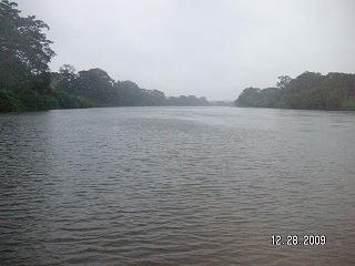
El Corte River is the primary tributary of the Coatzacoalcos River, flowing through the Mexican states of Oaxaca and Veracruz to the Gulf of Mexico.
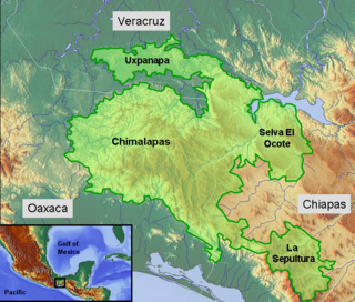
The Selva Zoque, which includes the Chimalapas rain forest, is an area of great ecological importance in Mexico. Most of the forest lies in the state of Oaxaca but parts are in Chiapas and Veracruz. It is the largest tract of tropical rainforest in Mexico, and contains the majority of terrestrial biodiversity in the country. The forest includes the Selva El Ocote, a federally-protected biosphere reserve, but is otherwise not yet protected. Despite the rich ecology of the region, a 2003 study that focused on bird populations stated that "the fauna of the heart of the Chimalapas, including its vast rainforests, have seen little or no study". As it is an impoverished region, efforts to preserve the ecology are often at odds with demands to improve the economy.

Juchitán District is located in the east of the Istmo de Tehuantepec region of the State of Oaxaca, Mexico, covering the southern part of a low-lying corridor through the mountains that separates the Gulf of Mexico from the Pacific ocean. The district has an area of 13,300 km2 and a population as of 2005 of 339,445.
Luis Marin was a spanish conquistador who served first under Captain Francisco de Saucedo then later directly under Captain General Hernán Cortés himself during several military campaigns in New Spain including the fall of Tenochtitlan, the Hibueras campaign and many other deployments along southeastern Mexico, Guatemala and Honduras. He is known as the captain who lead many Conquistadors including famous Conquistador and memoir-writer Bernal Díaz del Castillo into several military campaigns to conquer or reconquer sections in southeastern Mexico. Marin would become a close friend and confidant of Cortés serving him from 1519 until 1531, the year after Cortes returned from Spain.
The 1959 Coatzacoalcos earthquake occurred at 02:25 local time on August 26 near the Mexican state of Veracruz. The earthquake measured 6.4 Mw at a depth of 21 km (13 mi), and had a maximum Modified Mercalli intensity of VIII (Severe). It had an epicenter immediately off the coast of Coatzacoalcos. The shallow back-arc thrust faulting earthquake damaged the cities of Acayucan, Coatzacoalcos, Jáltipan and Minatitlán. A total of 25 people died, including 10 from Jáltipan while a further 200 were injured. The Middle America Trench, a subduction zone that borders the southwestern coast of Mexico and Central America, accounts for much of the seismicity in Mexico. The eastern side of the country near the Gulf of Mexico rarely experiences large earthquakes although they have been recorded around the Veracruz area, where seismicity is higher compared to other parts of the gulf. Seismicity in the gulf is attributed to back-arc compression due to subduction.

The Interoceanic Corridor of the Isthmus of Tehuantepec, abbreviated as CIIT, is an ongoing Mexican construction project, under the control of the Secretariat of the Navy, which seeks to connect the Pacific and Atlantic Oceans through a railway system "Ferrocarril del Istmo de Tehuantepec", both for cargo and passengers, that crosses the Isthmus of Tehuantepec, and through the modernization and growth of seaports, particularly the ports of Salina Cruz (Oaxaca) and Coatzacoalcos (Veracruz), and of the Minatitlán oil refinery and the Salina Cruz oil refinery in Southern Mexico. In addition, it also plans to attract private investors through the creation of 10 industrial parks in the Isthmus area. The project has the goal of developing the economy and industry of the Mexican South through encouraging economic investment, both national and international, and facilitate commerce and transportation of goods internationally.


