Cochranton, Pennsylvania

Last updated
Cochranton, Pennsylvania
Rusty Adams Street.jpg
Adams Street Bridge over French Creek. This bridge was replaced in late 2015.
Crawford County Pennsylvania Incorporated and Unincorporated areas Cochranton Highlighted.svg
Location of Cochranton in Crawford County, Pennsylvania.
USA Pennsylvania location map.svg
Red pog.svg
Cochranton
Location of Cochranton in Pennsylvania
Coordinates: 41°31′10″N80°2′56″W / 41.51944°N 80.04889°W / 41.51944; -80.04889
CountryUnited States
State Pennsylvania
County Crawford County
Founded1800
Government
  MayorMark Roche
Area
[1]
  Total1.20 sq mi (3.11 km2)
  Land1.20 sq mi (3.11 km2)
  Water0.00 sq mi (0.00 km2)
Elevation
[2] (middle of borough)
1,065 ft (325 m)
Highest elevation
[2] (Northeast corner of borough)
1,300 ft (400 m)
Lowest elevation1,050 ft (320 m)
Population
 (2020) [3]
  Total1,121
  Estimate 
(2022) [4]
1,107
  Density930.89/sq mi (359.52/km2)
Time zone UTC-4 (EST)
  Summer (DST) UTC-5 (EDT)
ZIP code
16314 [5]
Area code 814
Website cochrantonboro.org

Cochranton is a borough in Crawford County, Pennsylvania, United States. The population was 1,124 at the 2020 census, [6] down from 1,136 as of the 2010 census. [7]

Contents

Geography

Cochranton is located on the southern boundary of Crawford County at 41°31′10″N80°2′56″W / 41.51944°N 80.04889°W / 41.51944; -80.04889 (41.519497, -80.048906). [8] It is bordered by East Fairfield Township to the north, Wayne Township to the east, and Fairfield Township to the southwest.

According to the United States Census Bureau, the borough has a total area of 1.2 square miles (3.1 km2), all land. French Creek, a southeastward-flowing tributary of the Allegheny River, forms the southwestern border of the borough. Little Sugar Creek enters the borough from the east, passes north of the center of town, and joins French Creek just north of the Adams Street bridge.

U.S. Route 322 passes through the northern part of the borough, bypassing the downtown. US 322 leads 10 miles (16 km) northwest to Meadville, the county seat, and southeast 16 miles (26 km) to Franklin on the Allegheny River. Pennsylvania Route 173 passes through the borough center as Adams Street, leading northeast 8 miles (13 km) to Mount Hope and south 10 miles (16 km) to New Lebanon. Pennsylvania Route 285 departs PA 173 just west of the borough limits, leading west 8 miles (13 km) to Interstate 79 near Custards.

Creation of Borough

Cochranton was created by order of the Crawford County Court of Quarter Sessions on April 5, 1855. Early settler Charles Cochran, along with other residents of the community, had petitioned the county court for borough status. [9] The borough consists of the original land grants of John Adams and Thomas Cochran (who may have been distantly related to petitioner Charles Cochran). The borough plot was surveyed by Joseph Cochran, the first school teacher, and the son of Thomas Cochran. [10]

The first election was held on April 14, 1855. James Greer was elected Burgess, and the first borough council consisted of Charles Cochran, D. M. DeVore, Samuel Markle, William T. Dunn, and Hugh Smith. [9]

Demographics

Historical population
CensusPop.Note
1860 250
1870 45983.6%
1880 64540.5%
1890 6551.6%
1900 640−2.3%
1910 6958.6%
1920 647−6.9%
1930 72712.4%
1940 7939.1%
1950 1,09237.7%
1960 1,1394.3%
1970 1,2297.9%
1980 1,2400.9%
1990 1,174−5.3%
2000 1,148−2.2%
2010 1,136−1.0%
2020 1,121−1.3%
2022 (est.)1,107 [4] −1.2%
Sources: [11] [12] [13] [14] [3]

As of the census [12] of 2000, there were 1,148 people, 478 households, and 335 families residing in the borough. The population density was 953.8 inhabitants per square mile (368.3/km2). There were 506 housing units at an average density of 420.4 per square mile (162.3/km2). The racial makeup of the borough was 98.78% White, 0.44% African American, 0.09% Native American, 0.26% Asian, and 0.44% from two or more races. Hispanic or Latino of any race were 0.09% of the population.

There were 478 households, of which 28.2% had children under the age of 18 living with them, 55.9% were married couples living together, 10.7% had a female householder with no husband present, and 29.9% were non-families. 26.4% of all households were made up of individuals, and 14.4% comprised someone living alone who was 65 years of age or older. The average household size was 2.40 and the average family size was 2.84.

The age distribution of the borough was: 23.3% under the age of 18; 7.4% from 18 to 24; 26.4% from 25 to 44; 26.2% from 45 to 64; and 16.7% 65 years of age or older. The median age was 41 years. For every 100 females there were 90.4 males. For every 100 females age 18 and over, there were 90.7 males.

The median income for a household in the borough was $36,625, and the median income for a family was $45,463. Males had a median income of $33,333 versus $21,792 for females. The per capita income for the borough was $18,960. About 6.7% of families and 11.3% of the population were below the poverty line, including 23.2% of those under age 18 and 11.8% of those age 65 or over.

Related Research Articles

<span class="mw-page-title-main">Crawford County, Pennsylvania</span> County in Pennsylvania, United States

Crawford County is a county in the Commonwealth of Pennsylvania. As of the 2020 census, the population was 83,938. Its county seat is Meadville. The county was created on March 12, 1800, from part of Allegheny County and named for Colonel William Crawford.

<span class="mw-page-title-main">Blooming Valley, Pennsylvania</span> Borough in Pennsylvania, United States

Blooming Valley is a borough in Crawford County, Pennsylvania, United States. The population was 342 at the 2020 census, up from 337 at the 2010 census.

<span class="mw-page-title-main">Cambridge Springs, Pennsylvania</span> Home rule municipality in Pennsylvania, United States

Cambridge Springs is a borough with home rule status in Crawford County, Pennsylvania, United States. The population was 2,583 at the 2020 census, down from 2,595 at the 2010 census.

<span class="mw-page-title-main">Conneaut Lake, Pennsylvania</span> Borough in Pennsylvania, United States

Conneaut Lake is a borough in Crawford County, Pennsylvania, located at the southern end of the lake of the same name. The population was 625 at the 2020 census, down from 653 at the 2010 census.

<span class="mw-page-title-main">Conneaut Lakeshore, Pennsylvania</span> Census-designated place in Pennsylvania, United States

Conneaut Lakeshore is a census-designated place (CDP) in Crawford County, Pennsylvania, United States. The population was 2,395 at the 2010 census.

<span class="mw-page-title-main">Conneautville, Pennsylvania</span> Borough in Pennsylvania, United States

Conneautville is a borough in Crawford County, Pennsylvania, United States, situated along Conneaut Creek. The population was 736 at the 2020 census, down from 774 at the 2010 census.

<span class="mw-page-title-main">East Fairfield Township, Crawford County, Pennsylvania</span> Township in Pennsylvania, United States

East Fairfield Township is a township in Crawford County, Pennsylvania, United States. It was formed from Fairfield Township in 1869. The population was 837 at the 2020 census.

<span class="mw-page-title-main">Greenwood Township, Crawford County, Pennsylvania</span> Township in Pennsylvania, United States

Greenwood Township is a township in Crawford County, Pennsylvania, United States. The population was 1,424 at the 2020 census, down from 1,454 at the 2010 census.

<span class="mw-page-title-main">Hayfield Township, Crawford County, Pennsylvania</span> Township in Pennsylvania, United States

Hayfield Township is a township in Crawford County, Pennsylvania, United States. The population was 2,776 at the 2020 census, down from 2,940 at the 2010 census.

<span class="mw-page-title-main">Linesville, Pennsylvania</span> Borough in Pennsylvania, United States

Linesville is a borough in Crawford County, Pennsylvania, United States. The population was 961 at the 2020 census, down from 987 at the 2019 census. The town derives its name from its founders, who included William Line, who migrated from Carlisle, Pennsylvania, circa the early 1820s, and his relative, Amos Line, who was the town's surveyor and main proprietor. Amos Line "penetrated the western Pennsylvania wilderness as a member of the Pennsylvania Population Company in the early 1800s."

<span class="mw-page-title-main">Saegertown, Pennsylvania</span> Borough in Pennsylvania, United States

Saegertown is a borough in Crawford County, Pennsylvania. The population was 869 at the time of the 2020 census, down from 997 at the 2010 census. It was established in 1824.

<span class="mw-page-title-main">Spartansburg, Pennsylvania</span> Borough in Pennsylvania, United States

Spartansburg is a borough in Crawford County, in northwestern Pennsylvania, United States. The population was 277 at the 2020 census, down from 305 at the 2010 census.

<span class="mw-page-title-main">Springboro, Pennsylvania</span> Borough in Pennsylvania, United States

Springboro is a borough in Crawford County, Pennsylvania, United States, located 35 miles southwest of Erie. The population was 376 at the 2020 census, down from 477 at the 2010 census.

<span class="mw-page-title-main">Venango, Pennsylvania</span> Borough in Pennsylvania, United States

Venango is a borough in Crawford County, Pennsylvania, United States. The population was 210 at the 2020 census, down from 239 at the 2010 census, down from 288 in 2000.

<span class="mw-page-title-main">Venango Township, Crawford County, Pennsylvania</span> Township in Pennsylvania, United States

Venango Township is a township in Crawford County, Pennsylvania, United States. The population was 941 at the 2020 census, down from 997 at the 2010 census.

<span class="mw-page-title-main">Vernon Township, Crawford County, Pennsylvania</span> Township in Pennsylvania, United States

Vernon Township is a township in Crawford County, Pennsylvania, United States. The population was 5,310 at the 2020 census, down from 5,630 at the 2010 census.

<span class="mw-page-title-main">Wayne Township, Crawford County, Pennsylvania</span> Township in Pennsylvania, United States

Wayne Township is a township in Crawford County, Pennsylvania, United States. The population was 1,408 at the 2020 census, down from 1,539 at the 2010 census.

<span class="mw-page-title-main">Woodcock, Pennsylvania</span> Borough in Pennsylvania, United States

Woodcock is a borough in Crawford County, Pennsylvania, United States. The population was 140 at the 2020 census, down from 157 at the 2010 census.

<span class="mw-page-title-main">McKean, Pennsylvania</span> Borough in Pennsylvania, United States

McKean is a borough in Erie County, Pennsylvania. The population was 475 at the time of the 2020 census. It is part of the Erie–Meadville combined statistical area. McKean was known as "Middleboro" until it officially changed its name in 1970.

<span class="mw-page-title-main">Crawford Central School District</span> School district in Pennsylvania

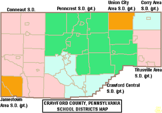
The Crawford Central School District is a midsized, public school district in Crawford County, Pennsylvania. It serves the City of Meadville, Borough of Cochranton and East Fairfield Township, Fairfield Township, Union Township, Vernon Township, Wayne Township and West Mead Township as well as a small portion of Greenwood Township in Crawford County, Pennsylvania, as well as French Creek Township in neighboring Mercer County, Pennsylvania. Crawford Central School District encompasses approximately 156 square miles. According to 2000 federal census data, it serves a resident population of 30,882 people. By 2010, the district's population declined to 30,635 people. In 2009, the Crawford Central School District residents' per capita income was $18,463, while the median family income was $43,771. In the Commonwealth, the median family income was $49,501 and the United States median family income was $49,445, in 2010. By 2013, the median household income in the United States rose to $52,100.

References

  1. "ArcGIS REST Services Directory". United States Census Bureau. Retrieved October 12, 2022.
  2. 1 2 3 "Conneaut Outlet Topo Map, Crawford County PA (Cochranton Area)". TopoZone. Locality, LLC. Retrieved 2 September 2019.
  3. 1 2 "Census Population API". United States Census Bureau. Retrieved Oct 12, 2022.
  4. 1 2 Bureau, US Census. "City and Town Population Totals: 2020-2022". Census.gov. US Census Bureau. Retrieved August 24, 2023.
  5. "Cochranton PA ZIP Code". zipdatamaps.com. 2023. Retrieved June 27, 2023.
  6. Bureau, US Census. "City and Town Population Totals: 2020-2021". Census.gov. US Census Bureau. Retrieved 25 June 2022.
  7. "Geographic Identifiers: 2010 Census Summary File 1 (G001): Cochranton borough, Pennsylvania". U.S. Census Bureau, American Factfinder. Archived from the original on February 13, 2020. Retrieved June 3, 2015.
  8. "US Gazetteer files: 2010, 2000, and 1990". United States Census Bureau. 2011-02-12. Retrieved 2011-04-23.
  9. 1 2 The Cochranton Times 125th Anniversary, page 1, The Cochranton Scroll, June 1980
  10. Community Focus - Cochranton, The Meadville Tribune, February 14, 2022, page B1
  11. "Census of Population and Housing". U.S. Census Bureau. Retrieved 11 December 2013.
  12. 1 2 "U.S. Census website". United States Census Bureau . Retrieved 2008-01-31.
  13. "Incorporated Places and Minor Civil Divisions Datasets: Subcounty Resident Population Estimates: April 1, 2010 to July 1, 2012". Population Estimates. U.S. Census Bureau. Archived from the original on 11 June 2013. Retrieved 11 December 2013.
  14. "Census of Population and Housing". Census.gov. Retrieved June 4, 2016.