Cohocton, New York

Last updated

Cohocton
USA New York location map.svg
Red pog.svg
Cohocton
Location of Cohocton in New York
Coordinates: 42°30′02″N77°30′01″W / 42.50056°N 77.50028°W / 42.50056; -77.50028
CountryUnited States
State New York
County Steuben
Established1812
Area
[1]
  Total56.09 sq mi (145.27 km2)
  Land56.08 sq mi (145.25 km2)
  Water0.01 sq mi (0.02 km2)
Population
 (2020) [2]
  Total2,268 Decrease2.svg
  Estimate 
(2021) [2]
2,239
  Density44.49/sq mi (17.18/km2)
Time zone UTC-5 (Eastern (EST))
  Summer (DST) UTC-4 (EDT)
FIPS code 36-101-16738

Cohocton is a town in Steuben County, New York, United States. The population was 2,268 at the 2020 census. [2] The town contains a village, also called Cohocton and is located in the northwestern part of the county.

Contents

History

The town was first settled around 1794. The town was formed from the towns of Bath and Dansville in 1812. It was originally known as the town of Liberty. Part of the town was later used to form new towns in the county: Avoca (1843) and Wayland (1848). In 1874, the town was enlarged by the addition of a part of the town of Prattsburgh. The Larrowe House, also known as The Cohocton Town and Village Hall and located at the village of Cohocton, was listed on the National Register of Historic Places in 1989. [3] At least as late as 1836 the spellings Cohocton and Conhocton were used, even in the same text, [4] but by 1860 the shorter spelling was consistent. [5]

Geography

According to the United States Census Bureau, the town has a total area of 56.1 square miles (145.2 km2), all land.

The northern town line is the border of Livingston and Ontario counties.

Interstate 390, New York State Route 21, New York State Route 371 and New York State Route 415 pass through the town. The Interstate and NY-415 partly follow the course of the Cohocton River.

Demographics

Historical population
CensusPop.Note
1820 1,560
1830 2,71173.8%
1840 2,9659.4%
1850 1,993−32.8%
1860 2,53527.2%
1870 2,7106.9%
1880 3,34623.5%
1890 3,4442.9%
1900 3,197−7.2%
1910 2,926−8.5%
1920 2,585−11.7%
1930 2,516−2.7%
1940 2,474−1.7%
1950 2,418−2.3%
1960 2,4511.4%
1970 2,379−2.9%
1980 2,4663.7%
1990 2,5202.2%
2000 2,6264.2%
2010 2,561−2.5%
2020 2,268−11.4%
2021 (est.)2,239 [2] −1.3%
U.S. Decennial Census [6]

As of the census [7] of 2000, there were 2,626 people, 972 households, and 704 families residing in the town. The population density was 46.8 inhabitants per square mile (18.1/km2). There were 1,144 housing units at an average density of 20.4 per square mile (7.9/km2). The racial makeup of the town was 97.49% White, 0.46% Black or African American, 0.61% Native American, 0.27% Asian, 0.19% from other races, and 0.99% from two or more races. Hispanic or Latino of any race were 0.27% of the population.

There were 972 households, out of which 38.7% had children under the age of 18 living with them, 57.5% were married couples living together, 9.1% had a female householder with no husband present, and 27.5% were non-families. 21.3% of all households were made up of individuals, and 9.5% had someone living alone who was 65 years of age or older. The average household size was 2.69 and the average family size was 3.10.

In the town, the population was spread out, with 28.8% under the age of 18, 7.0% from 18 to 24, 29.4% from 25 to 44, 22.4% from 45 to 64, and 12.4% who were 65 years of age or older. The median age was 36 years. For every 100 females, there were 98.9 males. For every 100 females age 18 and over, there were 98.5 males.

The median income for a household in the town was $35,559, and the median income for a family was $39,583. Males had a median income of $28,333 versus $25,208 for females. The per capita income for the town was $15,243. About 12.9% of families and 17.6% of the population were below the poverty line, including 25.1% of those under age 18 and 9.3% of those age 65 or over.

The 1890 population was 3,475.

Communities and locations in the Town of Cohocton

Railroad station at Atlanta, NY, in April 2011 Railroad station at Atlanta Apr 11.JPG
Railroad station at Atlanta, NY, in April 2011

This village is also in the Cohocton Valley. Formerly called Bloods, it was thought that it might prove more prosperous, and grow fully as well, if given a more pleasing name. Atlanta is a shipping point for an abundant supply of grapes which are grown around the village of Naples." [9]

Notable person

Related Research Articles

<span class="mw-page-title-main">Colesville, New York</span> Town in New York, United States

Colesville is a town in Broome County, New York, United States. The population was 4,877 at the 2020 census.

<span class="mw-page-title-main">Danube, New York</span> Town in New York, United States

Danube is a town in Herkimer County, New York, United States. The population was 801 at the 2020 census, down from 1,039 in 2010. Early Palatine German immigrants in the eighteenth century named the town after the Danube River in Europe.

Groveland is a town in Livingston County, New York, United States. The population was 3,249 at the 2010 census. The town is centrally located in the county, south of Geneseo.

Springwater is a town in Livingston County, New York, United States. The population was 2,439 at the 2010 census. Springwater is in the southeast part of the county.

West Sparta is a town in Livingston County, New York, United States. The population was 1,255 at the 2010 census. The name is derived from the neighboring town of Sparta.

<span class="mw-page-title-main">Moreau, New York</span> Town in New York, United States

Moreau is a town in Saratoga County, New York, United States. The population was 16,202 at the 2020 census. The town is located in the northeast part of the county, north of Saratoga Springs. Moreau is named after Jean Victor Moreau, a French general, who visited the area just before the town was formed. The town contains a village called South Glens Falls.

Campbell is a town in Steuben County, New York, United States. The population was 3,163 at the 2020 census. The name is from Robert Campbell, an early landowner. The town is centrally located in the county and is northwest of Corning.

<span class="mw-page-title-main">Erwin, New York</span> Town in New York, United States

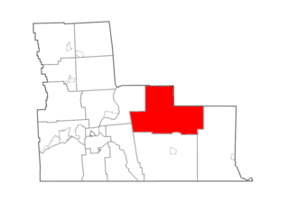
Erwin is a town in Steuben County, New York, United States. The population was 8,090 at the 2020 census. The name is that of an early settler, who became the first Town Supervisor. Erwin is in the southeast part of the county and is west of the city of Corning.

<span class="mw-page-title-main">Painted Post, New York</span> Village in New York, United States

Painted Post is a village in Steuben County, New York. The village is in the town of Erwin, west of the city of Corning. The population was 1,809 at the 2010 census. The name comes from a Seneca carved post found by explorers at the junction of three local rivers. Corning-Painted Post Airport (7N1) is west of the village.

<span class="mw-page-title-main">Smyrna, New York</span> Town in New York, United States

Smyrna is a town in Chenango County, New York, United States. The population was 1,280 at the 2010 census. Smyrna is named after a coastal city in ancient Greece, nowadays modern Izmir in Turkey.

<span class="mw-page-title-main">Chatham, New York</span> Town in New York, United States

Chatham is a town in Columbia County, New York, United States. The population was 4,104 at the 2020 census, down from the 2010 census.

Avon is a town in Livingston County, New York, United States. It is south of Rochester. The town population was 7,146 at the 2010 census. The town was named after the River Avon in England. The village of Avon is in the northwest part of the town.

<span class="mw-page-title-main">Richmondville, New York</span> Town in New York, United States

Richmondville is a town in Schoharie County, New York, United States. The population was 2,466 at the 2020 census. The town name was adapted from the name of a post office in its territory.

<span class="mw-page-title-main">Addison (village), New York</span> Village in New York, United States

Addison is a village in Steuben County, New York, United States, in the southeast part of the town of the same name, and southwest of the city of Corning. The population was 1,763 at the 2010 census. The village and the surrounding town are named after the author Joseph Addison.

<span class="mw-page-title-main">Avoca, New York</span> Town in New York, United States

Avoca is a town in Steuben County, New York, United States. The population was 1,996 at the 2020 census.

<span class="mw-page-title-main">Bath, New York</span> Town in New York, United States

Bath is a town in Steuben County, New York, United States, with an area of 96.3 square miles and a population of 11,426 in 2020. Its largest settlement is the Village of Bath, which has an area of 2.9 sq mi and a population of 5,641. The Village is the county seat of Steuben County. The Town is located in the central part of the county, northwest of Elmira. The town and village are either named after the city of Bath in England or after Lady Bath, daughter of a landowner.

<span class="mw-page-title-main">Cohocton (village), New York</span> Village in New York, United States

Cohocton is a village in Steuben County, New York, United States. The population was 838 at the 2010 census. The name is derived from an Iroquois phrase for "log in the water."

Corning is a town in Steuben County, New York, United States. The town is in the eastern part of the county and borders the city of Corning. The town population was 5,986 at the 2020 census. The town is named after Erastus Corning, a financier.

Wayland is a town in Steuben County, New York, United States. The population was 3,733 at the 2020 census.

<span class="mw-page-title-main">Plattekill, New York</span> Place in New York, United States

Plattekill is a town in Ulster County, New York, United States. The population was 10,424 in 2020, a slight decrease from 10,499 at the 2010 census. The name is derived from a stream, the Platte Kill.

References

  1. "2016 U.S. Gazetteer Files". United States Census Bureau. Retrieved July 5, 2017.
  2. 1 2 3 4 Bureau, US Census. "City and Town Population Totals: 2020—2021". Census.gov. US Census Bureau. Retrieved October 4, 2022.
  3. "National Register Information System". National Register of Historic Places . National Park Service. March 13, 2009.
  4. Thomas F. Gordon, Gazetteer of the State of New York, 1836, pages 704, 706, 709, 710
  5. J. H. French, Gazetteer of the State of New York, 1860, pages 619-630
  6. "Census of Population and Housing". Census.gov. Retrieved June 4, 2015.
  7. "U.S. Census website". United States Census Bureau . Retrieved January 31, 2008.
  8. "National Register of Historic Places". WEEKLY LIST OF ACTIONS TAKEN ON PROPERTIES: 2/16/10 THROUGH 2/19/10. National Park Service. February 26, 2010.
  9. Summering on the Lackawanna, 1893. Delaware, Lackawanna and Western Railroad Company. 1893.