Colehill

Last updated

St. Michael's and All Angels' Church, Colehill, Dorset.jpg

Colehill is a parish neighbouring Wimborne Minster, in Dorset, England. It had a population of 7,000 in 2001, [1] which shrunk slightly to 6,927 people at the 2011 census. [2]

Contents

History

The name Colehill originated in 1431 as Colhulle, becoming Colhill in 1518 and Collehill in 1547, [3] later getting the simplified spelling of Colehill, but the origins of Colehill as a settlement predate this by a long way.

Six round barrows, which can still be seen, show that people lived here as early as 2000 BC. The River Stour would have been navigable; there is evidence that in about 500 BC, peoples from Continental Europe were populating the South West, bringing the culture of the early Iron Age. Fortifications at Hengistbury Head and more forts inland were established then.

Part of the tracks survive, running parallel to the river from the coastal fort through modern locations such as Parley and Stapehill to Badbury Rings. It is thought that the line of Middlehill Road derives from one of these very early tracks.

Later in Roman times Wimborne developed as an important trading centre on the River Stour, and as a junction for further tracks from Poole to Badbury Rings and on to Salisbury. Another track radiating eastward possibly set the line for what was to become in modern times the A31. Bridges replaced the fords (Canford) in about 100 AD.

There then followed the Saxon invasion and the formation of the Kingdom of Wessex. Agriculture became established and with it clearance of some small plots on the sunny heathland slopes around Colehill. Over the centuries farms grew until, with the impetus of the Inclosure Acts (1750 to 1860), they were consolidated into the estates that we know of today - Kingston Lacy, Hanham and Uddens estates.

Colehill today

There are two first schools in Colehill, (Colehill First School and Hayeswood First School [4] ), a primary school (St Catherine's RC Primary School & Kindergarten), a middle school (St Michael's) and a foundation school (Beaucroft Foundation School (SEND) [5] ).

There is also a private school (Dumpton's [6] ). The main public hall is Colehill Memorial Hall, and nearby is the community library which was re-opened in February 2013. [7] It is run by volunteers with some support from the then Dorset County Council and its successor council, Dorset Council. Colehill has a pharmacy, a hairdressers, and three post offices and convenience stores.

A parish plan for Colehill was published in 2008. Many of the planned actions have been implemented, including the community library mentioned above. A website was published in November 2008; it is updated regularly [8] and all local organisations are encouraged to contribute. Colehill appears on Twitter and Facebook.

Traffic calming in Middlehill Road has been introduced and the major roundabout on the A31 at Canford Bottom has been re-engineered. A parish initiative succeeded in rebuilding the Reef as a youth and community centre for the people of Colehill and Wimborne. Over £500K was raised locally and assistance given by East Dorset District Council. The building was completed in 2016 and is fully in use with the activities continuing to expand.

There are a few houses in Colehill dating from the 1860s and rapid expansion took place in the 20th century. The population rose from 1786 in 1951 to 5370 in 1971. Several large estates of modern family homes were built and there is quite a lot of infill building. The Parish Church, Church of England, is St Michaels and All Angels. [9]

It was designed by Caröe in 1893 and is a half brick and half timber construction in the Arts and Crafts style. Nearby and close to the war memorial at the centre of the village are the Triangle Woods which have village green status. There are areas of common land, a recreation ground at Oliver's Park, and a Local Nature Reserve at Leigh Common. The area is well wooded and the local Forestry Commission plantation at Cannon Hill is very popular for walking.

The District Council's Core Strategy, approved in 2013, placed over half of East Dorset's New Neighbourhood development in Colehill; it comprises 630 homes along the Cranborne Road and 350 south of the Leigh Road A31.

As of 2014 a significant part of Colehill (including the New Neighbourhoods) was designated as a parish ward of Wimborne. In part compensation areas of Stapehill, west of the Canford Bottom roundabout, were transferred from Ferndown to the Colehill parish ward.

Notable people

Politics

There are three electoral wards within the parish (Colehill East, Colehill Hayes & Colehill West). In the new unitary Dorset Council (May 2019) these wards were joined with the Wimborne Minster East electoral ward to form a two-member electoral division (Colehill & Wimborne Minster East).

Colehill became part of the Mid Dorset and North Poole constituency at the 2010 general election.

Related Research Articles

<span class="mw-page-title-main">Wimborne Minster</span> Town in Dorset, England

Wimborne Minster is a market town in Dorset in South West England, and the name of the Church of England church in that town. It lies at the confluence of the River Stour and the River Allen, 5 miles (8 km) north of Poole, on the Dorset Heaths, and is part of the South East Dorset conurbation. According to Office for National Statistics data the population of the Wimborne Minster built-up area as of 2014 was 15,552.

<span class="mw-page-title-main">Poole</span> Town in England

Poole is a coastal town and seaport on the south coast of England in the Bournemouth, Christchurch and Poole unitary authority area in Dorset, England. The town is 21 miles (34 km) east of Dorchester and adjoins Bournemouth to the east. Since 1 April 2019, the local authority is Bournemouth, Christchurch and Poole Council. The town had an estimated population of 151,500 making it the second-largest town in the ceremonial county of Dorset. Together with Bournemouth and Christchurch, the conurbation has a total population of nearly 400,000.

<span class="mw-page-title-main">East Dorset</span> Former non-metropolitan district in England

East Dorset was a local government district in Dorset, England. Its council met in Wimborne Minster between 2016 and 2019.

<span class="mw-page-title-main">A31 road</span> Major trunk road in southern England

The A31 is a major trunk road in southern England that runs from Guildford in Surrey to Bere Regis in Dorset. Its most well known section is the Hog's Back, a hilly ridge forming part of the North Downs, in the Surrey stretch between Guildford and Farnham.

<span class="mw-page-title-main">Corfe Mullen</span> Human settlement in England

Corfe Mullen is a village in Dorset, England, on the north-western urban fringe of the South East Dorset conurbation. The community had a population of 10,133 at the 2011 Census. It is served by six churches, four pubs, five schools, a library, various shops and local businesses, a village hall, and many community and sports organisations. On 10 December 2019 The Corfe Mullen Parish Council resolved to adopt Town Council status, citing potential financial benefits. In all other aspects Corfe Mullen is still very much a village, albeit a large one.

<span class="mw-page-title-main">Ferndown</span> Human settlement in England

Ferndown is a town and civil parish in Dorset in southern England, immediately to the north of Bournemouth and Poole. The parish, which until 1972 was called Hampreston, includes the communities of Hampreston, Longham, Stapehill and Trickett's Cross. At the 2011 Census, the population of the parish was 26,559, making Ferndown the largest inland town in Dorset in terms of population, being larger than Dorchester.

<span class="mw-page-title-main">Mid Dorset and North Poole (UK Parliament constituency)</span>

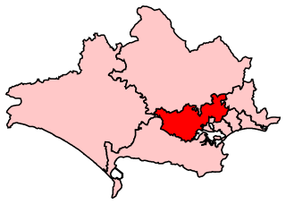
Mid Dorset and North Poole is a constituency represented in the House of Commons of the UK Parliament since 2015 by Michael Tomlinson, a Conservative.

<span class="mw-page-title-main">Kinson</span> Suburb of Bournemouth, England

Kinson is a former village which has been absorbed by the town of Bournemouth, in the Bournemouth, Christchurch and Poole district, in the ceremonial county of Dorset, England. The area became part of Bournemouth on 1 April 1931. There were two electoral wards containing the name Kinson. Their joint population at the 2011 Census was 19,824.

<span class="mw-page-title-main">Canford Magna</span> Village in Dorset, England

Canford Magna is a village in the Bournemouth, Christchurch and Poole district, in the ceremonial county of Dorset, England. The village is situated just south of the River Stour and lies between the towns of Wimborne Minster and Poole. The village has a mixture of thatch and brick buildings, mostly serving as residences for teaching staff. The western edge of the village merges with the residential suburb of Merley and the village community of Oakley.

<span class="mw-page-title-main">Transport in Dorset</span>

Dorset is a county in South West England. The county is largely rural and therefore does not have a dense transport network, and is one of the few English counties without a motorway. Owing to its position on the English Channel coast, and its natural sheltered harbours, it has a maritime history, though lack of inland transport routes have led to the decline of its ports.

<span class="mw-page-title-main">Oakley, Dorset</span> Human settlement in England

Oakley is a village community in Dorset, England. Sitting just south of the River Stour it borders the suburb of Merley and the village of Canford Magna to the East and South and the Town of Wimborne 2 km to the North. The B3073, which links Wimborne and Poole, runs through the community.

<span class="mw-page-title-main">Wimborne railway station</span> Disused railway station in Dorset, England

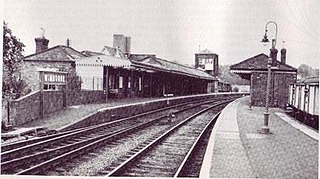
Wimborne was a railway station in Wimborne Minster in the county of Dorset in England. Open from 1 June 1847 to 2 May 1977, it was sited just north of the River Stour in what is still Station Road. Built for the Southampton and Dorchester Railway, the station was operated from the start by the London and South Western Railway, which took over ownership in 1848. It was then operated by the Southern Railway (1923–47) and from 1948 by the Southern Region of British Railways which traded as British Rail from 1965.

Fleetsbridge is a small area of Poole, Dorset, centred on a busy gyratory and flyover. It lies north of Poole town centre and borders the neighbouring suburbs of Waterloo, Creekmoor, Oakdale and Canford Heath. The use of land varies between residential, retail and some light industry. The area is also home to Parkstone Grammar School when it moved there from Lower Parkstone in 1962. The site of the Tesco at Fleets Corner was, up until the 1980s, the home of Hamworthy Recreation Football Club before the land was sold and the club moved to Canford Magna on the northern extreme of the Borough of Poole. Opposite to Tesco, across Waterloo Road, is the home of the headquarters of the global company, Hamworthy Combustion Engineering. Fleets Industrial Estate lies to the south of the gyratory off Fleets Lane and is adjacent to Wessex Gate Retail Park, which has large retail outlets such as DFS, Currys and PC World.

Colehill and Wimborne Minster East is an electoral ward in Dorset. Since 2019, the ward has elected 2 councillors to Dorset Council.

Wimborne Minster is an electoral ward in Dorset. Since 2019, the ward has elected 2 councillors to Dorset Council.

References

  1. Census data
  2. "Parish population 2011". Archived from the original on 2 April 2015. Retrieved 1 March 2015.
  3. "Colehill :: Survey of English Place-Names". epns.nottingham.ac.uk. Retrieved 29 April 2024.
  4. Dorset for You - Wimborne Schools Archived 27 September 2007 at the Wayback Machine
  5. Beaucroft's website
  6. Dumpton's website
  7. "About Us – Colehill Parish Council". colehill.gov.uk. Retrieved 29 April 2024.
  8. Colehill website
  9. Church Website
  10. "Former Dorset inventor of world wide web calls for digital "bill of rights" to protect internet users". Bournemouth Echo. 13 March 2014. Retrieved 24 February 2024.

50°48′N1°58′W / 50.800°N 1.967°W / 50.800; -1.967

Commons-logo.svg Media related to Colehill at Wikimedia Commons