Colfax, Wisconsin

Last updated

Colfax, Wisconsin
Dunn County Wisconsin Incorporated and Unincorporated areas Colfax Highlighted.svg
Location of Colfax
in Dunn County, Wisconsin
USA Wisconsin location map.svg
Red pog.svg
Colfax
Location within the state of Wisconsin
Usa edcp location map.svg
Red pog.svg
Colfax
Location within the United States
North America laea location map.svg
Red pog.svg
Colfax
Colfax (North America)
Coordinates: 44°59′55″N91°42′14″W / 44.99861°N 91.70389°W / 44.99861; -91.70389
Country Flag of the United States.svg  United States
State Flag of Wisconsin.svg  Wisconsin
County Dunn
Area
[1]
  Total1.42 sq mi (3.67 km2)
  Land1.39 sq mi (3.59 km2)
  Water0.03 sq mi (0.08 km2)
Elevation
[2]
981 ft (299 m)
Population
 (2020) [3]
  Total1,182
  Estimate 
(2019) [4]
1,158
  Density834.90/sq mi (322.25/km2)
Time zone UTC-6 (Central (CST))
  Summer (DST) UTC-5 (CDT)
Area code(s) 715 & 534
FIPS code 55-16300 [5]
GNIS feature ID1583001 [2]
Website http://www.villageofcolfaxwi.org/

Colfax is a village in Dunn County, Wisconsin, United States. The population was 1,158 at the 2010 census. The village is surrounded by the Town of Colfax.

Contents

History

The Colfax, Wisconsin tornado outbreak destroyed most of Colfax in 1958. The community was named for Schuyler Colfax, who served as vice president under Ulysses S. Grant. [6]

Geography

According to the United States Census Bureau, the village has a total area of 1.41 square miles (3.65 km2), of which, 1.38 square miles (3.57 km2) of it is land and 0.03 square miles (0.08 km2) is water. [7]

Colfax is located at 44°59′55″N91°43′31″W / 44.99861°N 91.72528°W / 44.99861; -91.72528 (44.998812, -91.725511). [8]

Colfax is along the Red Cedar River.

Wisconsin Highways 40 and 170 are main routes in the community. Other routes include County Roads BB, M, N, and W.

Demographics

Historical population
CensusPop.Note
1880 66
1910 701
1920 90529.1%
1930 9191.5%
1940 9927.9%
1950 1,0445.2%
1960 885−15.2%
1970 1,02615.9%
1980 1,14912.0%
1990 1,110−3.4%
2000 1,1362.3%
2010 1,1581.9%
2020 (est.)1,151 [9] −0.6%
U.S. Decennial Census [10]

2010 census

As of the census [3] of 2010, there were 1,158 people, 478 households, and 291 families living in the village. The population density was 839.1 inhabitants per square mile (324.0/km2). There were 524 housing units at an average density of 379.7 per square mile (146.6/km2). The racial makeup of the village was 97.2% White, 0.3% African American, 0.6% Native American, 0.2% from other races, and 1.7% from two or more races. Hispanic or Latino of any race were 1.7% of the population.

There were 478 households, of which 30.8% had children under the age of 18 living with them, 44.1% were married couples living together, 12.3% had a female householder with no husband present, 4.4% had a male householder with no wife present, and 39.1% were non-families. 33.9% of all households were made up of individuals, and 18% had someone living alone who was 65 years of age or older. The average household size was 2.29 and the average family size was 2.93.

The median age in the village was 41.8 years. 24.4% of residents were under the age of 18; 7.3% were between the ages of 18 and 24; 22.4% were from 25 to 44; 24.3% were from 45 to 64; and 21.6% were 65 years of age or older. The gender makeup of the village was 45.6% male and 54.4% female.

2000 census

As of the census [5] of 2000, there were 1,136 people, 467 households, and 294 families living in the village. The population density was 817.0 people per square mile (315.5/km2). There were 488 housing units at an average density of 351.0 per square mile (135.6/km2). The racial makeup of the village was 98.59% White, 0.26% Black or African American, 0.18% Native American, 0.26% from other races, and 0.70% from two or more races. 1.32% of the population were Hispanic or Latino of any race.

There were 467 households, out of which 30.8% had children under the age of 18 living with them, 51.2% were married couples living together, 9.4% had a female householder with no husband present, and 37.0% were non-families. 32.8% of all households were made up of individuals, and 18.2% had someone living alone who was 65 years of age or older. The average household size was 2.31 and the average family size was 2.92.

In the village, the population was spread out, with 24.2% under the age of 18, 6.3% from 18 to 24, 25.6% from 25 to 44, 20.6% from 45 to 64, and 23.2% who were 65 years of age or older. The median age was 40 years. For every 100 females, there were 87.5 males. For every 100 females age 18 and over, there were 85.2 males.

The median income for a household in the village was $31,118, and the median income for a family was $40,673. Males had a median income of $30,833 versus $21,741 for females. The per capita income for the village was $15,040. About 2.7% of families and 5.4% of the population were below the poverty line, including none of those under age 18 and 15.3% of those age 65 or over.

Education

Colfax schools include Colfax Elementary School, Colfax Middle School, and Colfax High School.

Newspaper

The Colfax Messenger, founded in 1897, is published weekly on Wednesdays. [11]

Museums

The Colfax Railroad Museum is located in Colfax.

Performing arts

The Red Cedar Sounds ECMB-RedCedarSounds.JPG
The Red Cedar Sounds

The Red Cedar Sounds, an award-winning chapter of Sweet Adelines International is based in Colfax. [12]

Related Research Articles

<span class="mw-page-title-main">Maryville, Illinois</span> Village in Illinois, United States

Maryville is a village in Madison County, Illinois, United States. The population was 8,221 at the 2020 census, up from 7,487 in 2010.

<span class="mw-page-title-main">Ruma, Illinois</span> Village in Illinois, United States

Ruma is a village in Randolph County, Illinois, United States. The population was 317 at the 2010 census.

<span class="mw-page-title-main">Ashton-Sandy Spring, Maryland</span> Census-designated place in Maryland, United States

Ashton-Sandy Spring is a census-designated place (CDP) in Montgomery County, Maryland, United States. The CDP is designated to include the two unincorporated communities of Ashton and Sandy Spring, as well as the smaller community of Brinklow. It had a population of 5,746 as of the 2020 census.

<span class="mw-page-title-main">Howells, Nebraska</span> Village in Nebraska, United States

Howells is a village in Colfax County, Nebraska, United States. The population was 561 at the 2010 census.

<span class="mw-page-title-main">Leigh, Nebraska</span> Village in Nebraska, United States

Leigh is a village in Colfax County, Nebraska, United States. The population was 405 at the 2010 census.

<span class="mw-page-title-main">Rogers, Nebraska</span> Village in Nebraska, United States

Rogers is a village in Colfax County, Nebraska, United States. The population was 95 at the 2010 census.

<span class="mw-page-title-main">Johnson, Nebraska</span> Village in Nemaha County, Nebraska, United States

Johnson is a village in Nemaha County, Nebraska, United States. The population was 313 at the 2020 census.

<span class="mw-page-title-main">Hollansburg, Ohio</span> Village in Ohio, United States

Hollansburg is a village in Darke County, Ohio, United States. The population was 243 at the 2020 census.

<span class="mw-page-title-main">Ogle Township, Pennsylvania</span> Township in Pennsylvania, United States

Ogle Township is a township in Somerset County, Pennsylvania, United States. The population was 467 at the 2020 census. It is part of the Johnstown, Pennsylvania, Metropolitan Statistical Area.

<span class="mw-page-title-main">Hazelhurst, Wisconsin</span> Town in Wisconsin, United States

Hazelhurst is a town in Oneida County, Wisconsin, United States. The population was 1,267 at the 2000 census. The unincorporated community of Hazelhurst is located in the town.

<span class="mw-page-title-main">Weyerhaeuser, Wisconsin</span> Village in Wisconsin, United States

Weyerhaeuser is a village in Rusk County, Wisconsin, United States. The population was 238 at the 2010 census.

<span class="mw-page-title-main">Wild Rose, Wisconsin</span> Village in Wisconsin, United States

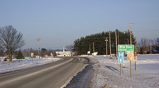
Wild Rose is a village in Waushara County, Wisconsin, United States. The population was 725 at the 2010 census.

<span class="mw-page-title-main">Unity, Wisconsin</span> Village in Wisconsin, United States

Unity is a village in Clark and Marathon counties in the U.S. state of Wisconsin. It is part of the Wausau, Wisconsin Metropolitan Statistical Area. The population was 343 at the 2010 census. Of this, 204 were in Marathon County, and 139 were in Clark County. The village is located in northeastern town of Unity in Clark County and northwestern town of Brighton in Marathon County.

<span class="mw-page-title-main">Lowell, Wisconsin</span> Village in Wisconsin, United States

Lowell is a village in Dodge County, Wisconsin, United States, along the Beaver Dam River. The population was 340 at the 2010 census. The village is located within the Town of Lowell.

Colfax is a town in Dunn County, Wisconsin, United States. The population was 909 at the 2000 census.

<span class="mw-page-title-main">Melrose, Wisconsin</span> Village in Wisconsin, United States

Melrose is a village in Jackson County, Wisconsin, United States. The population was 503 at the 2010 census. The village is located within the Town of Melrose.

<span class="mw-page-title-main">Necedah, Wisconsin</span> Village in Wisconsin, United States

Necedah is a village in Juneau County, Wisconsin, United States. The population was 916 at the 2010 census. The village is located within the Town of Necedah.

The Town of Spencer is located in Marathon County, Wisconsin, United States. It is part of the Wausau, WI Metropolitan Statistical Area. The population was 1,581 at the 2010 census. The village of Spencer is located in the northeastern part of the town.The unincorporated community of Mann also is located in the town.

Ellsworth is a town in Pierce County, Wisconsin, United States. The population was 1,064 at the 2000 census. The Village of Ellsworth is located within the town. The unincorporated community of Lawton is also located partially in the town.

<span class="mw-page-title-main">Scandinavia, Wisconsin</span> Village in Wisconsin, United States

Scandinavia is a village in the Town of Scandinavia in Waupaca County, Wisconsin, United States. The population was 328 at the 2010 census.

References

  1. "2019 U.S. Gazetteer Files". United States Census Bureau. Retrieved August 7, 2020.
  2. 1 2 "US Board on Geographic Names". United States Geological Survey. October 25, 2007. Retrieved January 31, 2008.
  3. 1 2 "U.S. Census website". United States Census Bureau . Retrieved November 18, 2012.
  4. "Population and Housing Unit Estimates". United States Census Bureau. May 24, 2020. Retrieved May 27, 2020.
  5. 1 2 "U.S. Census website". United States Census Bureau . Retrieved January 31, 2008.
  6. Callary, Edward (2016). Place Names of Wisconsin. Madison, WI: University of Wisconsin Press. p. 62. ISBN   978-0-299-30964-0.
  7. "US Gazetteer files 2010". United States Census Bureau. Archived from the original on July 2, 2012. Retrieved November 18, 2012.
  8. "US Gazetteer files: 2010, 2000, and 1990". United States Census Bureau. February 12, 2011. Retrieved April 23, 2011.
  9. "County Population Totals: 2010-2020" . Retrieved June 20, 2021.
  10. "Census of Population and Housing". Census.gov. Retrieved June 4, 2015.
  11. Colfax Messenger
  12. http://www.region22.org/colfa,.html%5B%5D