Collingham, Nottinghamshire

Last updated

Collingham
Village and civil parish
Collingham-HighStreet.jpg
The north end of the High Street showing the Grey Horse public house (left).
Collingham, Nottinghamshire
Parish map
Nottinghamshire UK location map.svg
Red pog.svg
Collingham
Location within Nottinghamshire
Area8.64 sq mi (22.4 km2)
Population3,052 (2021)
  Density 353/sq mi (136/km2)
OS grid reference SK 835615
  London 115 mi (185 km)  SSE
District
Shire county
Region
Country England
Sovereign state United Kingdom
Settlements
  • North Collingham
  • South Collingham
  • Brough
  • Danethorpe
  • Danethorpe Hill
Post town NEWARK
Postcode district NG23
Dialling code 01636
Police Nottinghamshire
Fire Nottinghamshire
Ambulance East Midlands
UK Parliament
Website collingham-pc.gov.uk
List of places
UK
England
Nottinghamshire
53°08′52″N0°45′33″W / 53.14778°N 0.75917°W / 53.14778; -0.75917

Collingham is a village and civil parish in Nottinghamshire, England. The population at the 2011 census was 2,738, [1] increasing to 3,052 at the 2021 census. [2]

Contents

Collingham is on the River Trent and the A1133 main road, just off the A46, 6 miles (9.7 km) from Newark-on-Trent, 15 miles (24.1 km) from Lincoln, and 28 miles (45.1 km) from Nottingham.

The civil parish of Collingham comprises the villages of Brough, Danethorpe and Danethorpe Hill and Collingham itself, which is made up of North Collingham and South Collingham; each with a medieval church. [3]

History

Collingham is close to the old Roman fort at Brough and there have been several local finds of Roman coins, jewellery and villa remains. It lies close to the Fosse Way on its way to Lincoln. The village name suggests a fairly early Saxon foundation, preceding the occupation of eastern England by the Danes and it is naturally mentioned in the Domesday Book. It is thought that the Great North Road crossed the Trent here before Newark was founded; prior to the river's change of channel westwards it ran close to the village and was the cause of much flooding. Many of the other villages close by have names which suggest that they were later daughter settlements. It possessed two churches in North and South Collingham from before the Norman conquest. The parishes extended from the river floodplain onto the uncultivated moorland on the higher ground between Trent and Witham, allowing for good grazing and meadowland throughout the year.

In medieval and early modern times Collingham operated an openfield system and enclosure did not take place until the turn of the 18th/19th centuries, changing much local farming from a small holding of strips and the right to extensive grazing, to individual small cottage holdings or a precarious existence as a landless agricultural labourer. The wide square fields and relatively few isolated farms are the result. One field was set aside in the enclosure award of 1790 for lease every year with the revenues being put to the use of the poor of the parish. Around the end of the 18th and beginning of the 19th century there was an influx of agricultural labour, displaced from the enclosures of the upland Lincolnshire villages in places like Boothby Graffoe, Coleby and Harmston, taking the place of former Collingham people who had moved to towns such as Lincoln, Newark and Nottingham in search of better employment.

During the siege of Newark in the English Civil War, the countryside was subject to deprivation from the opposing armies wanting food and fresh horses and the village suffered. In 1664, a mercer of Collingham, one Thomas Ridge, issued his own copper halfpenny tokens, in response to currency shortage after the civil war.

In the 19th century Collingham was fairly self-sufficient with its own watchmaker, shoemakers, blacksmiths, dressmakers, schools, grocers and carriers. There were many local societies and the Nonconformist churches had their own congregations. At one point there was considerable enmity between the vicar of North Collingham and the rector of South Collingham with many disputes about the schools in the village. There are a large number of listed buildings in the village , from the c16 through to the c19, and the village is highly valued as a place to live and commute from.

Facilities

The Co-op. Collingham Co-op (geograph 4979186).jpg
The Co-op.
Church of All Saints, North Collingham Church of All Saints, North Collingham - geograph.org.uk - 53848.jpg
Church of All Saints, North Collingham
Church of St. John the Baptist, South Collingham Church of St. John the Baptist, South Collingham - geograph.org.uk - 53849.jpg
Church of St. John the Baptist, South Collingham

Local amenities include the Co-op and One-Stop convenience stores, butcher's, general store, newsagent and post office. There is a medical centre/dentist/pharmacy complex which serves much of the surrounding area, plus a library in the same building. Now collectively known as Collingham Village Centre, negotiations are currently under way between Collingham Parish Council, Lincolnshire Co-operative, Collingham Football Club, and other interested parties, to build a new, much larger, Co-op supermarket, and a greatly enlarged car park. This will add another two to four retail outlets in the Village Centre, and is supported by the majority of the villagers who voted in a Parish Council survey.

There are some sporting facilities in Collingham, notably Collingham F.C. and Collingham Cricket Club. There are also facilities for tennis, bowling and croquet while the nearby River Trent seems very popular with anglers [ citation needed ].

Collingham is fairly easy to get to by road or railway, being very close to the A46 and 5.5 miles from the A1/A46 junction at Newark-on-Trent. Collingham is served by the Nottingham-Lincoln railway line used by East Midlands Trains, which passes close to the east side of the village, where there is the station, and you can reach most parts of the Midlands. There is an East Coast station at Newark Northgate from which London can be reached as well as all locations on the East Coast Main Line. A bus service to Newark operates on an irregular basis, with two daily buses running to Lincoln on a daily basis.

Bypass

One ongoing issue affecting the village regards a bypass. The issue is not new, and has surfaced a number of times over the past sixty years or so, the last time being rejected in favour of another project in the county, a new bus station in Mansfield. The proposed bypass is not seen as a priority and in addition would damage the countryside and natural environment along the east side of the village.[ citation needed ]Many villagers pose the argument that the damage to the environment would be more than offset by the reduction in damage to the built environment along the High Street, and the cessation of the use of Low Street as a 'rat run' to avoid the traffic lights at the Station Road junction. Pressure groups within the village continue to campaign for the bypass to be built, regardless of how remote the possibility.

Notable people

The composer John Blow was born in the village. Two brothers from the village, John and William Bacon, took part in the Charge of the Light Brigade (under the assumed name of Baker). William was killed, but John returned, later leaving the Army. Both are buried in North Collingham churchyard.

Drummer William Bowerman, formerly of I Was a Cub Scout and Brontide is from Collingham.

See also

Related Research Articles

<span class="mw-page-title-main">Newark-on-Trent</span> Market town in Nottinghamshire, England

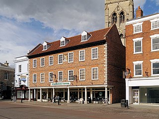
Newark-on-Trent or Newark is a market town and civil parish in the Newark and Sherwood district in Nottinghamshire, England. It is on the River Trent, and was historically a major inland port. The A1 road bypasses the town on the line of the ancient Great North Road. The town's origins are likely to be Roman, as it lies on a major Roman road, the Fosse Way. It grew up round Newark Castle, St Mary Magdalene church and later developed as a centre for the wool and cloth trades.

<span class="mw-page-title-main">A46 road</span> Road in England

The A46 is a major A road in England. It starts east of Bath, Somerset and ends in Cleethorpes, Lincolnshire, but it does not form a continuous route. Large portions of the old road have been lost, bypassed, or replaced by motorway development. Between Leicester and Lincoln the road follows the course of the Roman Fosse Way, but between Bath and Leicester, two cities also linked by the Fosse Way, it follows a more westerly course.

<span class="mw-page-title-main">West Lindsey</span> District in England

West Lindsey is a local government district in Lincolnshire, England. Its council is based in Gainsborough, the district's largest town. The district also includes the towns of Caistor and Market Rasen, along with numerous villages and surrounding rural areas. The east of the district includes part of the Lincolnshire Wolds, a designated Area of Outstanding Natural Beauty.

<span class="mw-page-title-main">Bingham, Nottinghamshire</span> Town in Nottinghamshire, England

Bingham is a market town and civil parish in the Rushcliffe borough of Nottinghamshire, England, 9 miles (14 km) east of Nottingham, 12 miles south-west of Newark-on-Trent and 15 miles west of Grantham. The town had a population of 9,131 at the 2011 census, with the population now sitting at 10,108 from the results of the 2021 census data.

<span class="mw-page-title-main">Nettleham</span> Village in Lincolnshire, England

Nettleham is a large village and civil parish within the West Lindsey district of Lincolnshire, England, 4 miles (6.4 km) north-east from the city of Lincoln between the A46 and A158.

<span class="mw-page-title-main">Norton Disney</span> Village and civil parish in Lincolnshire, England

Norton Disney is a small village and civil parish on the western boundary of the North Kesteven district of Lincolnshire, England. It is situated on the border with the adjacent county of Nottinghamshire and shares a boundary with Collingham in that county. This county and parish boundary of Collingham and Norton Disney also splits the Potter Hill area which has important Iron Age and Roman archaeology. The population of the civil parish at the 2011 census was 226. It lies midway between Lincoln and Newark, 2 miles (3.2 km) to the south-east of the A46.

Lincolnshire is a large county in England with a sparse population distribution, which leads to problems funding all sorts of transport. The transport history is long and varied, with much of the road network still based on the Roman model, and the once extensive rail network a shadow of its former self.

Harby is a village and civil parish in the Newark and Sherwood district of Nottinghamshire, England. It is close to the Lincolnshire border with Doddington. According to the 2011 census, it had a population of 336, up from 289 at the 2001 census.

<span class="mw-page-title-main">A17 road (England)</span> Road in England

The A17 road is a mostly single carriageway road linking Newark-on-Trent in Nottinghamshire, England, to King's Lynn in Norfolk. It stretches for a distance of 62 miles travelling across the flat fen landscapes of southern Lincolnshire and western Norfolk and links the East Midlands with East Anglia. The road is notable for its numerous roundabouts and notoriously dangerous staggered junctions and also for its most famous landmark, the Cross Keys Bridge at Sutton Bridge close to the Lincolnshire/Cambridgeshire/Norfolk borders which carries the road over the River Nene.

<span class="mw-page-title-main">Besthorpe, Nottinghamshire</span> Village in Nottinghamshire, England

Besthorpe is a small village in north-east Nottinghamshire close to the border with Lincolnshire. It is a civil parish in the Newark & Sherwood district of Nottinghamshire. The population of the civil parish as of the 2011 census was 195, increasing to 212 at the 2021 census. The village is on the A1133 between Newark and Gainsborough, and is 1.5 miles north of the larger village of Collingham, north east of Newark on Trent. The village lies 1 mile east of the River Trent and the River Fleet flows south to east parallel with the village & A1133. Besthorpe acquired Conservation Village status in 2006 because it has maintained much of its original layout focused on Low Road and the Green.

Kneeton is a village in the county of Nottinghamshire, England. The population as of the 2011 census remained less than 100. It is included in the civil parish of Screveton. The village lies on the A46 road between Nottingham and Newark and is on the escarpment of the Trent Hills that sit above the flood plain of the River Trent. RAF Syerston is nearby. There is a railway station at Lowdham. The church is 14th century Grade II listed, and dedicated to St. Helen. A mid-18th century Grade II listed barn survives at Hall Farm, Kneeton.

<span class="mw-page-title-main">Tuxford</span> Town and civil parish in Nottinghamshire, England

Tuxford is a historic market town and a civil parish in the Bassetlaw district of Nottinghamshire, England. It had a population of 2,809 in the 2021 census.

<span class="mw-page-title-main">Farndon, Nottinghamshire</span> Village in England

Farndon is a small village and civil parish in Newark and Sherwood district of Nottinghamshire, England. It is on the historic Fosse road and is 3 miles (4 km) south-west of Newark-on-Trent. It is on the banks of the River Trent. The population of the civil parish as of the 2011 census was 2,405. The A46 previously ran through the village until the development of a new dual carriageway bypass.

<span class="mw-page-title-main">Elston</span> Village in Nottinghamshire, England

Elston is a village and civil parish in Nottinghamshire, England, to the south-west of Newark, and a mile from the A46 Fosse Way. The population of the civil parish taken at the 2011 Census was 631. It lies between the rivers Trent and Devon, with the village "set amongst trees and farmland less than a mile from the A46.... Newark is five miles to the north, with... Lincoln and Nottingham some 18 miles north and south-west respectively."

<span class="mw-page-title-main">Colston Bassett</span> Human settlement in England

Colston Bassett is an English village in the Vale of Belvoir, in the Rushcliffe district of south-east Nottinghamshire, close to its border with Leicestershire. It lies by the River Smite. The population in 2001 of 225, including Wiverton Hall, increased to 399 at the 2011 Census, finally falling to 356 in the 2021 Census

<span class="mw-page-title-main">Misterton, Nottinghamshire</span> Village and civil parish in the Bassetlaw district of Nottinghamshire, England

Misterton is a village and civil parish in the Bassetlaw district of Nottinghamshire, England. The parish population at the 2011 census was 2,140, and has risen to 2,191 residents in the 2021 census.

<span class="mw-page-title-main">A631 road</span> Road in England

The A631 is a road running from Sheffield, South Yorkshire to Louth, Lincolnshire in England. It passes through the counties of South Yorkshire, Nottinghamshire and Lincolnshire. The road has many towns on its route including Rotherham, Maltby, Gainsborough and Market Rasen. It is mostly single road throughout its length but has some stretches of dual carriageway as well.

<span class="mw-page-title-main">Thoroton</span> Human settlement in England

Thoroton is a small English parish in the borough of Rushcliffe, Nottinghamshire, with a population of 112. The village has conservation area status. Its Anglican parish church is a Grade I listed building.

<span class="mw-page-title-main">Langford, Nottinghamshire</span> Human settlement in England

Langford is a village and civil parish in Nottinghamshire, England. It is located four miles north-east of Newark-on-Trent and two miles East from The River Trent. Population details are included in the civil parish of Holme. It is based on A1133 which comes off of the A46. Although Langford is currently located two miles from The River Trent it has not always been this way. In "1575 there was a cataclysmic flood" which altered the course of the Trent which meant Langford and Holme were now on the same side of the river. Before this change in the rivers course the Trent used to flow next to St Bartholomew's church and Holme was on the opposite side of the bank.

Brough is a hamlet in Nottinghamshire, England.

References

  1. "Civil Parish population 2011". Neighbourhood Statistics. Office for National Statistics. Retrieved 6 April 2016.
  2. UK Census (2021). "2021 Census Area Profile – Collingham (Newark and Sherwood) parish (E04007892)". Nomis. Office for National Statistics . Retrieved 1 February 2024.
  3. "Collingham Parish Council". 22 January 2024. Retrieved 1 February 2024.

Commons-logo.svg Media related to Collingham, Nottinghamshire at Wikimedia Commons

53°08′52″N0°45′33″W / 53.14778°N 0.75917°W / 53.14778; -0.75917 (Collingham, Nottinghamshire)