Swabia is one of the seven administrative regions of Bavaria, Germany. It consists of ten districts and 340 municipalities.

Lower Franconia is one of seven districts of Bavaria, Germany. The districts of Lower, Middle and Upper Franconia make up the region of Franconia. It consists of nine districts and 308 municipalities.

Upper Franconia is a Regierungsbezirk of the state of Bavaria, southern Germany. It forms part of the historically significant region of Franconia, the others being Middle Franconia and Lower Franconia, which are all now part of the German Federal State of Bayern (Bavaria).

Middle Franconia is one of the three administrative regions of Franconia, Germany, in the west of Bavaria bordering the state of Baden-Württemberg. The administrative seat is Ansbach; the most populous and largest city is Nuremberg.

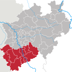
Arnsberg is one of the five Regierungsbezirke of North Rhine-Westphalia, Germany, located in the west-central part of the country. It covers the Sauerland hills as well as the east part of the Ruhr area.

Detmold is one of the five Regierungsbezirke of North Rhine-Westphalia, Germany, located in the north-east of the state. It is congruent with region of Ostwestfalen-Lippe.

Düsseldorf is one of the five Regierungsbezirke of North Rhine-Westphalia, Germany, located in the north-west of the country. It covers the western part of the Ruhr Area, as well as the Niederrheinische Tiefebene, the lower Rhine area. It is the most populated of all German administrative areas of the kind. It is the only area in Germany where the traditional dialects are Low Franconian, rather than Low German or High German.

Münster is one of the five Regierungsbezirke of North Rhine-Westphalia, Germany, located in the north of the state, and named after the capital city of Münster. It includes the area which in medieval times was known as the Dreingau.

Upper Bavaria is one of the seven administrative districts of Bavaria, Germany.

Lower Bavaria is one of the seven administrative regions of Bavaria, Germany, located in the east of the state. It consists of nine districts and 258 municipalities.
The Upper Palatinate is an administrative district in the east of Bavaria, Germany. It consists of seven districts and 226 municipalities, including three cities.

Kassel is one of the three Regierungsbezirke of Hesse, Germany, located in the north of the state. It was created in 1866 when Prussia annexed the Electorate of Hesse, forming part of the new Province of Hesse-Nassau. It was enlarged following the incorporation of the former Free State of Waldeck in 1929. From 1944 to 1945 it formed its own province: Kurhessen. After World War II it became part of Greater Hesse within the American Occupation Zone, the precursor to the modern state of Hesse. In its modern form it consists of 138 municipalities.
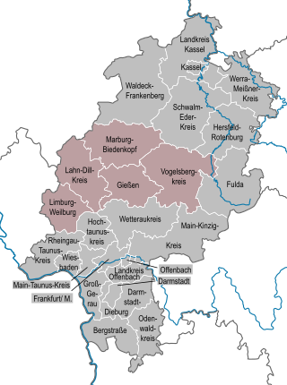
Giessen is one of the three Regierungsbezirke of Hesse, Germany, located in the middle of the state. It was created on 1 January 1981 from the districts of Giessen, Lahn-Dill and Limburg-Weilburg and the Vogelsbergkreis, all formerly belonging to Darmstadt, and Marburg-Biedenkopf, formerly belonging to Kassel.

Darmstadt is one of the three Regierungsbezirke of Hesse, Germany, located in the south of the state. The other two Regierungsbezirke are Giessen and Kassel

Freiburg is one of the four Regierungsbezirke of Baden-Württemberg, Germany, located in the south-west of the country. It covers the Black Forest (Schwarzwald) hills as well as the Rhine valley. It is sub-divided into the three regions (Regionalverband) Hochrhein-Bodensee, Schwarzwald-Baar-Heuberg and Südlicher Oberrhein. It is divided into nine districts and 294 municipalities.

Tübingen is one of the four Administrative Regions of Baden-Württemberg, Germany, located in the south-east of the state. It covers most of the German shore of Lake Constance (Bodensee), and also the beginning of the Danube River valley. It is sub-divided into the three regions : Neckar-Alb, Donau-Iller and Bodensee-Oberschwaben. Donau-Iller also includes three districts and one city of Bavaria.

Stuttgart is one of the four administrative districts of Baden-Württemberg, Germany, located in the north-east of the state of Baden-Württemberg, in the southwestern part of Germany. It is sub-divided into the three regions: Heilbronn-Franken, Ostwürttemberg and Stuttgart.
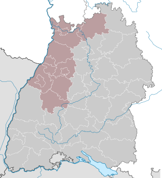
Karlsruhe is one of the four administrative regions of Baden-Württemberg, Germany, located in the north-west of the state. It is subdivided into the three regional associations : Mittlerer Oberrhein, Rhein-Neckar (Rhine-Neckar) and Nordschwarzwald (Northern Black Forest).

Chemnitz was one of the three former Direktionsbezirke of Saxony, Germany, located in the south-west of the state. It coincided with the Planungsregion Südsachsen. It was disbanded in March 2012.

Świętokrzyskie Voivodeship, also known as Świętokrzyskie Province and Holy Cross Province or Holy Cross Voivodeship, is a voivodeship (province) in southeastern Poland, in the historical region of Lesser Poland. The province's capital and largest city is Kielce.