This article is about the fur district of the Hudson's Bay Company in the Pacific Northwest. For the US capital district (District of Columbia), see Washington, D.C. For other uses, see District of Columbia (disambiguation).
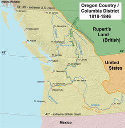
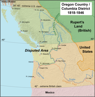
Map of the Oregon Country "jointly occupied" by the United States and the United Kingdom; the Columbia Department at its greatest extent included areas far to the north and to the south.
Country
British North America
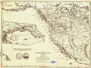
Map of the Columbia River and its tributaries showing modern political boundaries. In 1811 David Thompson was the first European to journey the entire length of the Columbia.
The Columbia District was a fur trading district in the Pacific Northwest region of British North America in the 19th century. Much of its territory overlapped with the disputed Oregon Country. It was explored by the North West Company between 1793 and 1811, and established as an operating fur district around 1810. The North West Company was absorbed into the Hudson's Bay Company in 1821 under which the Columbia District became known as the Columbia Department. The Oregon Treaty of 1846 marked the effective end of the Hudson's Bay Company's Columbia Department.
Beginning in 1807, David Thompson, working for the North West Company (NWC), explored much of what would become the Columbia District. In 1811 he located Athabasca Pass, which became the key overland connection to the emerging fur district.[1]
The American Pacific Fur Company (PFC) founded Fort Astoria near the entrance of the Columbia River and began to counter the interior NWC trade posts. Funded largely by German-American merchant John Jacob Astor, the company men had previously sailed around Cape Horn on board Tonquin. During the War of 1812, the Pacific Northwest was a distant region of the conflict. Prior to the war, both companies operated in the region peaceably with each other. News of a coming British warship put the American company into a difficult position. In October 1813, management met at Fort Astoria and agreed to liquidate its assets to the NWC. HMSRacoon arrived the following month and in honor of George III of the United Kingdom, Fort Astoria was renamed to Fort George.[2]
Under the North West Company the Columbia District was bounded, roughly, by the southern edge of the Thompson River on the north, and by the southern and eastern limits of the Columbia River basin. North and west of the Thompson was the New Caledonia fur district, in what is now north-central British Columbia. The Thompson River region was its own fur district, centered on a fur trading post that later became the city of Kamloops. The Thompson River District was the link between the Columbia and New Caledonia Districts.
In the Treaty of 1818 between the U.S. and Britain, the two powers agreed that each had free and open access to the Oregon Country. This "joint occupation" continued until the Oregon Treaty of 1846, yet American attempts to conduct commercial operations in the region failed in the face of competition by the Hudson's Bay Company. The only sphere in which the Americans temporarily dominated was the maritime fur trade along the coast. But the HBC successfully took over the coastal maritime trade during the 1830s through various means, such as constructing trading forts.[3]
The North West Company found the Native Americans of the Columbia region generally unwilling to work as fur trappers and hunters. The company depended upon native labor east of the Rocky Mountains and found it difficult to operate without assistance in the west. For this reason the company began, in 1815, to bring groups of Iroquois, skilled at hunting and trapping, from the Montreal region to the Pacific Northwest. This practice soon became standard policy and was continued for many years by both the North West Company and the Hudson's Bay Company and was essential for the extension of the fur trade into much of the Columbia basin. The Iroquois were intended not only to support company personnel but, it was hoped, teach local natives the skills of hunting and trapping, and convince them to take up the work. This effort was largely unsuccessful. The reason generally given for the unwillingness of the natives to take up trapping and hunting was that their way of life was highly focused on salmon and fishing, and that the abundance of salmon resulted in little incentive for taking up hunting and trapping. Instead of cooperation there were altercations between the Iroquois and local natives. In 1816 parties of the North West Company, including a number of Iroquois, explored the Cowlitz River valley and the Willamette Valley, reaching as far south as the Umpqua River. Both exploring expeditions ended with violent clashes between the Iroquois and local natives.[4] In addition the North West Company began to hire Native Hawaiians, known as Kanakas. This practice was continued and greatly expanded by the Hudson's Bay Company.
The North West Company was unchallenged in the fur trade of the region from 1813 to 1821, when it was merged with the Hudson's Bay Company. During this period the company put into practice the system attempted by the Astorians' Pacific Fur Company. A supply ship arrived each spring at Fort George (Astoria). Fur brigades from the interior of the Columbia and New Caledonia districts would converge on Fort George each spring. Furs were loaded on the ship and supplies carried back to the interior. The ship would then carry the furs to Canton, China, where furs would be exchanged for tea and other goods, which were then carried to Britain, completing a global circuit. Company letters, reports, and personnel were generally conveyed overland along a route between Fort George and Fort William on Lake Superior, making use of Athabasca Pass.[5] Later, under the Hudson's Bay Company, the York Factory Express used this route, reoriented to York Factory on Hudson Bay.
The Columbia District under the North West Company was only marginally profitable at best. There were numerous problems at many posts. The only consistently profitable areas were the Kootenay River and Snake River countries. New Caledonia produced many furs, but its remoteness made it costly to operate. Nevertheless, the North West Company succeeded in creating a functional network oriented to the Pacific via the Columbia River. Another important legacy was the construction of Fort Nez Perces on the Columbia River near its confluence with the Snake River. Fort Nez Perces would long remain a strategic site, located at the junction of a variety of trails leading to vastly different regions. The fort became an important center for the procurement of horses, a base for expeditions far to the southeast, and a focal point for fur brigades preparing to journey through the Columbia River Gorge.[5] The shipping of furs to Canton, China, was a financial failure for both the North West Company and, later, the Hudson's Bay Company, in part due to the East India Company's monopoly on British trade in the Far East.[6]
Hudson's Bay Company
The North West Company was merged with the Hudson's Bay Company in 1821. Operations west of the Rocky Mountains were reorganized and the fur districts of New Caledonia and Columbia were merged in 1827 under the name Columbia Department.[6] The name New Caledonia continued to be used for the old northern district, and in time came to be used for areas such as the Fraser Canyon and the Lower Mainland.
In 1824 the Hudson's Bay Company built Fort Vancouver on the lower Columbia River to serve as the headquarters of the entire Columbia Department, which was previously the role of Fort Astoria (renamed Fort George).
The Hudson's Bay Company York Factory Express, overland route to Fort Vancouver, evolved from an earlier express brigade used by the North West Company between Fort Astoria (renamed Fort George) to Fort William on Lake Superior. By 1825 there were usually two brigades, each setting out in spring from opposite ends of the route, Fort Vancouver, and York Factory on Hudson Bay, and passing each other in the middle of the continent. Each brigade consisted of about forty to seventy five men and two to five specially made boats and traveled at breakneck speed (for the time). Indians along the way were often paid in trade goods to help them portage around falls and unnavigable rapids. An 1839 report cites the travel time as three months and ten days—almost 26 miles (40km) per day on average.[7] This established a 'quick' (about 100 days for 2600 miles (4200km)) way to resupply their forts and fur trading centers as well as transmitting messages between Fort Vancouver and York Factory on Hudson Bay.
Map of the route of the York Factory Express, 1820s to 1840s, with modern political boundaries shown
The supplies were brought into Fort Vancouver and York Factory by ship every year (they tried to maintain one years extra supplies to avoid disastrous ship wrecks etc.). The furs they had traded were shipped back on the supply ships with the furs from Fort Vancouver often being shipped to China where they were traded for Chinese goods before returning to England. The furs from York factory being sold in London in an annual fur sale. The brigades carried supplies in and furs out by boat, horseback and as back packs for the forts and trading posts along the route. They also carried status reports for supplies needed, furs traded etc. from Dr. John McLoughlin, Chief Factor of the Columbia District HBC operations, and the other fort managers along the route. This continued until 1846.
Between the acquisition of the North West Company in 1821 and the Oregon Treaty of 1846, the HBC greatly expanded the operations of the Columbia Department. The fur trade was extended to essentially every major river from the Yukon River in the north to the mouth of the Colorado River in the south, and east to the headwaters of the Missouri River tributaries. American fur trade competition was effectively blocked through various strategies, including selectively overhunting frontier regions to create "fur deserts", and the construction of forts on the Pacific Northwest coast to intercept furs before American ships could acquire them.
The HBC also diversified their economic activity and began exporting agricultural foodstuffs, salmon, lumber, and other products. Russian Alaska, Hawaii, and Mexican California were developed as markets for these exports. The HBC opened agencies in Sitka, Honolulu, and Yerba Buena (San Francisco) to facilitate the trade.[8]
Fort Vancouver was the nexus for the fur trade on the Pacific Coast; its influence reached from the Rocky Mountains to the Hawaiian Islands, and from Alaska into Mexican-controlled California. At its pinnacle, Fort Vancouver watched over 34 outposts, 24 ports, six ships, and 600 employees.[citation needed] The employment of Hawaiian Kanakas was gradually expanded until at least 207 in the Columbia Department by 1845, with 119 located at Fort Vancouver.[9] Also, for many settlers the fort became the last stop on the Oregon Trail as they could get supplies before starting their homestead.
Increasing numbers of American settlers arriving on the Oregon Trail gave rise to the Oregon boundary dispute. With the signing of the Oregon Treaty in 1846 the U.S.-British boundary was fixed on the 49th parallel. This effectively destroyed the geographical logic of the HBC's Columbia Department, since the lower Columbia River was the core and lifeline of the system. The U.S. soon organized its portion as the Oregon Territory. The administrative headquarters of fur operations, and of the Columbia Department, then shifted to Fort Victoria, which had been founded by James Douglas in 1843 as a fall back position in preparation for the "worst case" scenario settlement of the dispute, in the face of manifest destiny.
By 1846, the Columbia District proper had been more than halved and the name had fallen into relative disuse, until revived when the new Mainland Colony needed a name. The uncharted territory of the remainder of the Columbia District, including the remainder of the British coast north of Puget Sound, as far north as at least Queen Charlotte Strait (Fort Simpson and Fort McLoughlin were administered from Fort St. James, the capital of New Caledonia). After 1846 New Caledonia informally referred to the Fraser Canyon Gold Rush region in 1848 and farther north the Cariboo Gold Rush area during the 1860s. As also had included Fort Langley since as early as 1827.
In their British Columbia Chronicle, historians Helen B. Akrigg and G.P.V. Akrigg coined the term "Southern Columbia" for the "lost" area south of the 49th Parallel, but this has never come into common use, even by other historians.
John McLoughlin, baptized Jean-Baptiste McLoughlin, was a French-Canadian, later American, Chief Factor and Superintendent of the Columbia District of the Hudson's Bay Company at Fort Vancouver from 1824 to 1845. He was later known as the "Father of Oregon" for his role in assisting the American cause in the Oregon Country. In the late 1840s, his general store in Oregon City was famous as the last stop on the Oregon Trail.
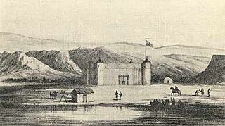
Fort Vancouver was a 19th-century fur trading post built in the winter of 1824–1825. It was the headquarters of the Hudson's Bay Company's Columbia Department, located in the Pacific Northwest. Named for Captain George Vancouver, the fort was located on the northern bank of the Columbia River in present-day Vancouver, Washington. The fort was a major center of the regional fur trading. Every year trade goods and supplies from London arrived either via ships sailing to the Pacific Ocean or overland from Hudson Bay via the York Factory Express. Supplies and trade goods were exchanged with a plethora of Indigenous cultures for fur pelts. Furs from Fort Vancouver were often shipped to the Chinese port of Guangzhou where they were traded for Chinese manufactured goods for sale in the United Kingdom. At its pinnacle, Fort Vancouver watched over 34 outposts, 24 ports, six ships, and 600 employees. Today, a full-scale replica of the fort, with internal buildings, has been constructed and is open to the public as Fort Vancouver National Historic Site.
Oregon Country was a large region of the Pacific Northwest of North America that was subject to a long dispute between the United Kingdom and the United States in the early 19th century. The boundaries of the area, which had been created by the Treaty of 1818 without recognizing indigenous claims to the area, consisted of the land north of 42° N latitude, south of 54°40′ N latitude, and west of the Rocky Mountains down to the Pacific Ocean and east to the Continental Divide. Article III of the 1818 treaty gave joint control to both nations for ten years, allowed land to be claimed, and guaranteed free navigation to all mercantile trade. However, both countries disputed the terms of the international treaty. Oregon Country was the American name while the British used Columbia District for the region. Meanwhile, Indigenous nations had lived in the area since time immemorial, though with little legal recognition in the American and British legal systems. Evidence along the Salmon River shows people lived there at least 16,000 years ago, and may have populated the continent after migrating along the Pacific Coast, then following up the Columbia River into the interior.
The Oregon boundary dispute or the Oregon Question was a 19th-century territorial dispute over the political division of the Pacific Northwest of North America between several nations that had competing territorial and commercial aspirations in the region.
Fort Astoria was the primary fur trading post of John Jacob Astor's Pacific Fur Company (PFC). A maritime contingent of PFC staff was sent on board the Tonquin, while another party traveled overland from St. Louis. This land based group later became known as the Astor Expedition. Built at the entrance of the Columbia River in 1811, Fort Astoria was the first American-owned settlement on the Pacific coast of North America.
New Caledonia was a fur-trading district of the Hudson's Bay Company that comprised the territory of the north-central portions of present-day British Columbia, Canada. Though not a British colony, New Caledonia was part of the British claim to North America. Its administrative centre was Fort St. James. The rest of what is now mainland British Columbia was called the Columbia Department by the British, and the Oregon Country by the Americans. Even before the partition of the Columbia Department by the Oregon Treaty in 1846, New Caledonia was often used to describe anywhere on the mainland not in the Columbia Department, such as Fort Langley in the Fraser Valley.
Fort Victoria began as a fur trading post of the Hudson's Bay Company and was the headquarters of HBC operations in the Columbia District, a large fur trading area now part of the province of British Columbia, Canada and the U.S. state of Washington. Construction of Fort Victoria in 1843 highlighted the beginning of a permanent British settlement now known as Victoria, the capital city of British Columbia. The fort itself was demolished in November 1864 as the town continued to grow as a commercial centre serving the local area as well as trading with California, Washington Territory, the United Kingdom, and others.
The trade center Fort Colvile was built by the Hudson's Bay Company (HBC) at Kettle Falls on the Columbia River in 1825 and operated in the Columbia fur district of the company. Named for Andrew Colvile, a London governor of the HBC, the fort was a few miles west of the present site of Colville, Washington. It was an important stop on the York Factory Express trade route to London via the Hudson Bay. The HBC for some time considered Fort Colvile second in importance only to Fort Vancouver, near the mouth of the Columbia, until the foundation of Fort Victoria.
Fort Nez Percés, later known as (Old) Fort Walla Walla, was a fortified fur trading post on the Columbia River on the territory of modern-day Wallula, Washington. Despite being named after the Nez Perce people, the fort was in the traditional lands of the Walla Walla. Founded in 1818 by the North-West Company, after 1821 it was run by the Hudson's Bay Company until its closure in 1857.
Fort Boise is either of two different locations in the Western United States, both in southwestern Idaho. The first was a Hudson's Bay Company (HBC) trading post near the Snake River on what is now the Oregon border, dating from the era when Idaho was included in the British fur company's Columbia District. After several rebuilds, the fort was ultimately abandoned in 1854, after it had become part of United States territory following settlement in 1846 of the northern boundary dispute.
Fort Okanogan was founded in 1811 on the confluence of the Okanogan and Columbia Rivers as a fur trade outpost. Originally built for John Jacob Astor’s Pacific Fur Company, it was the first American-owned settlement within Washington state, located in what is now Okanogan County. The North West Company, the PFC's primary competitor, purchased its assets and posts in 1813. In 1821 the North West Company was merged into Hudson's Bay Company, which took over operation of Fort Okanogan as part of its Columbia District. The fort was an important stop on the York Factory Express trade route to London via Hudson Bay.
Oregon pioneer history (1806–1890) is the period in the history of Oregon Country and Oregon Territory, in the present day state of Oregon and Northwestern United States.
The Puget Sound Agricultural Company (PSAC), with common variations of the name including Puget Sound or Puget's Sound, was a subsidiary joint stock company formed in 1840 by the Hudson's Bay Company (HBC). Its stations operated within the Pacific Northwest, in the HBC administrative division of the Columbia Department. The RAC-HBC Agreement was signed in 1839 between the Russian-American Company and the HBC, with the British to now supply the various trade posts of Russian America. It was hoped by the HBC governing committee that independent American merchants, previously a major source of foodstuffs for the RAC, would be shut out of the Russian markets and leave the Maritime fur trade.
Fort William was a fur trading outpost built in 1834 by the American Nathaniel Jarvis Wyeth, a Boston merchant, backed by American investors. It was located on the Columbia River on Wappatoo Island near the future Portland, Oregon. After a few years, in 1837 Wyeth sold the post to the British Hudson's Bay Company, which had much more power in the region from its base at Fort Vancouver on the north side of the Columbia River near Fort William.
Alexander Roderick McLeod was a fur trader and explorer in British North America who began his career with the North West Company in 1802.
The York Factory Express, usually called "the Express" and also the Columbia Express and the Communication, was a 19th-century fur brigade operated by the Hudson's Bay Company (HBC). Roughly 4,200 kilometres (2,600 mi) in length, it was the main overland connection between HBC headquarters at York Factory and the principal depot of the Columbia Department, Fort Vancouver.
Fort McLoughlin was a fur trading post established in 1833 by the Hudson's Bay Company (HBC) on Campbell Island in present-day British Columbia, Canada. At the time the Hudson's Bay Company performed quasi-governmental duties on behalf of the British Empire as well as undertaking trade for profit. The site is believed to have been at McLoughlin Bay on the northeast side of Campbell Island and is associated with the relocation of the Heiltsuk community of Bella Bella from its former location on islets near Denny Island. The McLoughlin name, which is that of John McLoughlin, regional head of company operations at that time, is also found in a lake and a creek entering that bay, and was conferred on these locations after the fort had closed.
Thomas McKay (1796–1849) was an Anglo-Métis Canadian fur trader who worked mainly in the Pacific Northwest for the Pacific Fur Company (PFC), the North West Company (NWC), and the Hudson's Bay Company (HBC). He was a fur brigade leader and explorer of the Columbia District and later became a U.S. citizen and an early settler of Oregon.
Fort Simpson was a fur trading post established in 1831 by the Hudson's Bay Company (HBC) near the mouth of the Nass River in present-day British Columbia, Canada. In 1834, it was moved to the Tsimpsean Peninsula, about halfway between the Nass River and the Skeena River, and was later referred to as Port Simpson or as the native name Lax Kw'alaams. The fort was part of the HBC's Columbia Department.
William Charles was a Pacific coast pioneer, Hudson's Bay Company factor, and a prominent figure in the early history of British Columbia.
Franchère, Gabriel (1969) [1854], Lamb, William (ed.), Journal of a Voyage on the North West Coast of North America during the Years 1811, 1812, 1813 and 1814, Toronto,Ontario: Champlain Society Publications, doi:10.3138/9781442618039, ISBN978-1-4426-1803-9
Koppel, Tom (1995), McLean, Elizabeth (ed.), Kanaka: The Untold Story of Hawaiian Pioneers in British Columbia and the Pacific Northwest, Vancouver, B.C.: Whitecap Books
Mackie, Richard Somerset (1997), Trading Beyond the Mountains: The British Fur Trade on the Pacific 1793–1843, Vancouver, B.C.: University of British Columbia Press
Meinig, D.W. (1995) [1968], The Great Columbia Plain (Weyerhaeuser Environmental Classiced.), Seattle: University of Washington Press
24. Claimed in 1908; territory formed 1962; overlaps portions of Argentine and Chilean claims, borders not enforced but claim not renounced under the Antarctic Treaty.
This page is based on this Wikipedia article Text is available under the CC BY-SA 4.0 license; additional terms may apply. Images, videos and audio are available under their respective licenses.