This article needs additional citations for verification .(February 2019) |
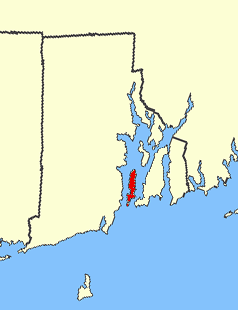
Cowesett is a hillside neighborhood located in Warwick, Rhode Island.
This article needs additional citations for verification .(February 2019) |
Cowesett is a hillside neighborhood located in Warwick, Rhode Island.
Cowesett is bounded on the north by Rhode Island Route 117, on the south by East Greenwich, Rhode Island, on the east by U.S. 1 (Post Road), and on the west by Crompton / Rhode Island Route 2. To the east is the neighborhood of Chepiwanoxet and Greenwich Bay, an arm of Narragansett Bay. Cowesett is known as the "Wellesley by the Sea"[ citation needed ] for its similarity to the affluent Wellesely, MA but near the coast. The neighborhood is in walking distance of Main Street and other attractions such as Scallop Town Park, Academy Field, and the town library in East Greenwich, Rhode Island.
The name Cowesett, which has had various spellings throughout history, may be derived from the Narragansett expression kówaw 'pine tree' + -es 'small' + -sett 'place', meaning 'Small Pine Place.' [1] This place name may have designated by metonymy the earliest inhabitants of this area prior to contact with Europeans.
The one public school located in Cowesett is Cedar Hill Elementary School, and students who live in the neighborhood also attend the public schools of Scott Elementary School, Winman Junior High School, and Toll Gate High School.
Cowesett is home to actor James Woods, former boxer Vinny Pazienza, and Olympic Gold Medalist Sara DeCosta. It is the former home of current Major League pitcher Dan Wheeler of the Tampa Bay Rays.
In 2010, the Massachusetts Bay Transit Authority (MBTA) opened up Warwick Station on the Providence/Stoughton Line, providing train service connecting T. F. Green Airport and Boston, Massachusetts.
Providence County is the most populous county in the U.S. state of Rhode Island. As of the 2020 census, the county's population was 660,741, or 60.2% of the state's population. Providence County contains the city of Providence, the state capital of Rhode Island and the county's most populous city, with an estimated 190,934 residents in 2020. Providence County is included in the Providence-Warwick, RI-MA Metropolitan Statistical Area, which in turn constitutes a portion of the greater Boston-Worcester-Providence, MA-RI-NH-CT Combined Statistical Area. As of 2010, the center of population in Rhode Island is located in Providence County, in the city of Cranston.
Swansea is a town in Bristol County in southeastern Massachusetts. It is located at the mouth of the Taunton River, just west of Fall River, 47 miles (76 km) south of Boston, and 12 miles (19 km) southeast of Providence, Rhode Island. The population was 17,144 at the 2020 census.

East Greenwich is a town and the county seat of Kent County, Rhode Island. The population was 14,312 at the 2020 census. East Greenwich is the wealthiest municipality within the state of Rhode Island. It is part of the Providence metropolitan statistical area and the Greater Boston combined statistical area.

Warwick is a city in Kent County, Rhode Island, the third largest city in the state with a population of 82,823 at the 2020 census. Warwick is located approximately 12 miles (19 km) south of downtown Providence, Rhode Island, 63 miles (101 km) southwest of Boston, Massachusetts, and 171 miles (275 km) northeast of New York City.
Potowomut is an isolated neighborhood and a peninsula in Warwick, Rhode Island. It is bordered by the Town of East Greenwich to the northwest, and by North Kingstown to the southeast. Greenwich Bay surrounds all other sides.

Narragansett Bay is a bay and estuary on the north side of Rhode Island Sound covering 147 square miles (380 km2), 120.5 square miles (312 km2) of which is in Rhode Island. The bay forms New England's largest estuary, which functions as an expansive natural harbor and includes a small archipelago. Small parts of the bay extend into Massachusetts.

The Colony of Rhode Island and Providence Plantations was one of the original Thirteen Colonies established on the east coast of America, bordering the Atlantic Ocean. It was founded by Roger Williams. It was an English colony from 1636 until 1707, and then a colony of Great Britain until the American Revolution in 1776, when it became the State of Rhode Island and Providence Plantations.

The Pokanoket was the village governed by Massasoit. The term broadened to refer to all peoples and lands governed by Massasoit and his successors, which were part of the Wampanoag people in what is now Rhode Island and Massachusetts.
Narragansett Bay divides the state of Rhode Island into two parts. The term East Bay refers to communities on the east side of the bay, including Bristol, Warren, Barrington, Tiverton, Little Compton, Newport, Middletown, Portsmouth and Jamestown. The term West Bay refers to communities on the west side of the bay, such as Warwick, Cranston and East Greenwich. Jamestown and the towns on Aquidneck Island are sometimes known as "The Islands" along with Block Island.

Scouting in Rhode Island has a long history, from the 1910s to the present day, serving thousands of youth in programs that suit the environment in which they live.

Riverside is a neighborhood in the city of East Providence in the U.S. state of Rhode Island. Despite not being an incorporated city, Riverside has its own zip code, 02915, and is an acceptable mailing address according to the United States Postal Service. Riverside has a population of approximately 20,000 people.
Oakland Beach is a neighborhood and beach located in the South Central area of Warwick, Rhode Island, on Greenwich Bay, a tributary of Narragansett Bay. In the late 1800s, Oakland Beach was the site of the camp ground for the six day annual training encampment of the Rhode Island Militia. Around 1895 the encampment was moved to a larger and better equipped facility at Quonset Point.

Apponaug is a neighborhood in central Warwick, Rhode Island, United States, situated on Apponaug Cove, a tributary to Greenwich Bay and nearby Narragansett Bay. The name Apponaug is a derivation of the Narragansett Indian word for "place of oysters". Indeed, Apponaug Cove holds one of the richest shellfish beds in the United States and was densely populated by the Narragansett people for many centuries prior to the arrival of European settlers.

Mount Hope Bay is a tidal estuary located at the mouth of the Taunton River on the Massachusetts and Rhode Island border. It is an arm of Narragansett Bay. The bay is named after Mount Hope, a small hill located on its western shore in what is now Bristol, Rhode Island. It flows into the East Passage of Narragansett Bay and also the Sakonnet River. Mount Hope Bay has played an important role to the history of the area, from pre-colonial times to the present. While many years of sewage and industrial pollution have severely degraded the quality of the shallow waters of the bay, there are currently major efforts underway to clean up and restore it.
The Maskerchugg River is a river in the U.S. state of Rhode Island. It flows approximately 6 km (4 mi). There are four dams along the river's length.

Greenwich Bay, is a bay on the coast of Rhode Island in the United States near Warwick, RI and East Greenwich, Rhode Island off of Narragansett Bay.

Washington County, known locally as South County, is a county located in the U.S. state of Rhode Island. As of the 2020 census, the population was 129,839. Rhode Island counties have no governmental functions other than as court administrative boundaries, which are part of the state government.
Centerville and Moscow are two rural adjacent villages in the town of Hopkinton, Rhode Island. Located just outside the village of Hope Valley, the two villages are very small and are only separated by Moscow Pond, a small pond in the Rockville Management Area in the northern section of town. Sometimes referred to as "Centerville-Moscow", the area is located on and around Rhode Island Route 138, known as Spring Street, between the villages of Hope Valley and Rockville.
| | This Rhode Island state location article is a stub. You can help Wikipedia by expanding it. |