
Parallax is a displacement or difference in the apparent position of an object viewed along two different lines of sight, and is measured by the angle or semi-angle of inclination between those two lines. Due to foreshortening, nearby objects show a larger parallax than farther objects when observed from different positions, so parallax can be used to determine distances.
A terminator or twilight zone is a moving line that divides the daylit side and the dark night side of a planetary body. The terminator is defined as the locus of points on a planet or moon where the line through the center of its parent star is tangent. An observer on the terminator of such an orbiting body with an atmosphere would experience twilight due to light scattering by particles in the gaseous layer.

Surveyor 1 was the first lunar soft-lander in the uncrewed Surveyor program of the National Aeronautics and Space Administration. This lunar soft-lander gathered data about the lunar surface that would be needed for the crewed Apollo Moon landings that began in 1969. The successful soft landing of Surveyor 1 on the Ocean of Storms was the first by an American space probe on any extraterrestrial body, occurring on the first attempt and just four months after the first Moon landing by the Soviet Union's Luna 9 probe.

Sunrise is the moment when the upper rim of the Sun appears on the horizon in the morning. The term can also refer to the entire process of the solar disk crossing the horizon and its accompanying atmospheric effects.

Dione is a moon of Saturn. It was discovered by Italian astronomer Giovanni Domenico Cassini in 1684. It is named after the Titaness Dione of Greek mythology. It is also designated Saturn IV.

Mars Global Surveyor (MGS) is an American robotic space probe developed by NASA's Jet Propulsion Laboratory and launched November 1996. MGS was a global mapping mission that examined the entire planet, from the ionosphere down through the atmosphere to the surface. As part of the larger Mars Exploration Program, Mars Global Surveyor performed atmospheric monitoring for sister orbiters during aerobraking, and helped Mars rovers and lander missions by identifying potential landing sites and relaying surface telemetry.

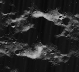
Tin Bider is an impact crater that sits in dry, rugged terrain in Algeria. The crater was formed in the last 70 million years, perhaps in the late Cretaceous or early Tertiary Period. Spanning 6 kilometres, the crater sits at the southern end of a range of hills. The elevated position and concentric rings of Tin Bider suggest that its structure is complex.

A coronagraph is a telescopic attachment designed to block out the direct light from a star so that nearby objects – which otherwise would be hidden in the star's bright glare – can be resolved. Most coronagraphs are intended to view the corona of the Sun, but a new class of conceptually similar instruments are being used to find extrasolar planets and circumstellar disks around nearby stars as well as host galaxies in quasars and other similar objects with active galactic nuclei (AGN).

Plato is a lava-filled lunar impact crater on the Moon. Its diameter is 101 km. It was named after ancient Greek philosopher Plato. It is located on the northeastern shore of the Mare Imbrium, at the western extremity of the Montes Alpes mountain range. In the mare to the south are several rises collectively named the Montes Teneriffe. To the north lies the wide stretch of the Mare Frigoris. East of the crater, among the Montes Alpes, are several rilles collectively named the Rimae Plato.

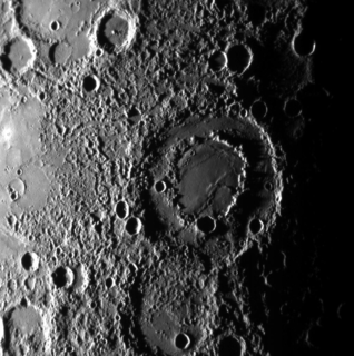
Shackleton is an impact crater that lies at the lunar south pole. The peaks along the crater's rim are exposed to almost continual sunlight, while the interior is perpetually in shadow. The low-temperature interior of this crater functions as a cold trap that may capture and freeze volatiles shed during comet impacts on the Moon. Measurements by the Lunar Prospector spacecraft showed higher than normal amounts of hydrogen within the crater, which may indicate the presence of water ice. The crater is named after Antarctic explorer Ernest Shackleton.
Malapert is a lunar impact crater that lies near the southern limb of the Moon. From the Earth this formation is viewed from the side, limiting the amount of detail that can be seen. The crater is also illuminated at very low angles, so that parts of the interior remain in almost constant darkness. The nearest craters of note are Cabeus to the west, and Shoemaker to the south-southeast and nearer to the south pole of the Moon.
The geology of Mercury is the scientific study of the surface, crust, and interior of the planet Mercury. It emphasizes the composition, structure, history, and physical processes that shape the planet. It is analogous to the field of terrestrial geology. In planetary science, the term geology is used in its broadest sense to mean the study of the solid parts of planets and moons. The term incorporates aspects of geophysics, geochemistry, mineralogy, geodesy, and cartography.

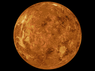
Venus is a planet with striking geology. Of all the other planets in the Solar System, it is the one nearest to Earth and most like it in terms of mass, but has no magnetic field or recognizable plate tectonic system. Much of the ground surface is exposed volcanic bedrock, some with thin and patchy layers of soil covering, in marked contrast with Earth, the Moon, and Mars. Some impact craters are present, but Venus is similar to Earth in that there are fewer craters than on the other rocky planets that are largely covered by them. This is due in part to the thickness of the Venusian atmosphere disrupting small impactors before they strike the ground, but the paucity of large craters may be due to volcanic re-surfacing, possibly of a catastrophic nature. Volcanism appears to be the dominant agent of geological change on Venus. Some of the volcanic landforms appear to be unique to the planet. There are shield and composite volcanoes similar to those found on Earth. Given that Venus has approximately the same size, density, and composition as Earth, it is plausible that volcanism may be continuing on the planet today, as demonstrated by recent studies.

STEREO is a solar observation mission. Two nearly identical spacecraft were launched in 2006 into orbits around the Sun that cause them to respectively pull farther ahead of and fall gradually behind the Earth. This enabled stereoscopic imaging of the Sun and solar phenomena, such as coronal mass ejections.

Third-party evidence for Apollo Moon landings is evidence, or analysis of evidence, about Moon landings that does not come from either NASA or the U.S. government, or the Apollo Moon landing hoax theorists. This evidence serves as independent confirmation of NASA's account of the Moon landings.

The geology of solar terrestrial planets mainly deals with the geological aspects of the four terrestrial planets of the Solar System – Mercury, Venus, Earth, and Mars – and one terrestrial dwarf planet: Ceres. Earth is the only terrestrial planet known to have an active hydrosphere.

The Lowell crater is a large impact crater on Aonia Terra in the Thaumasia quadrangle of Mars. The crater is about 203 kilometers in diameter. Lowell is an example of a well-preserved peak ring crater on Mars.
Solar eclipses on the Moon are caused when the planet Earth passes in front of the Sun and blocks its light. Viewers on Earth experience a lunar eclipse during a solar eclipse on the Moon.

Ahuna Mons is the largest mountain on the dwarf planet and asteroid Ceres. It protrudes above the cratered terrain, is not an impact feature, and is the only mountain of its kind on Ceres. Bright streaks run top to bottom on its slopes; these streaks are thought to be salt, similar to the better known Cererian bright spots, and likely resulted from cryovolcanic activity from Ceres's interior. It is named after the traditional post-harvest festival Ahuna of the Sumi Naga people of India. In July 2018, NASA released a comparison of physical features, including Ahuna Mons, found on Ceres with similar ones present on Earth.
The mapping of Venus refers to the process and results of human description of the geological features of the planet Venus. It involves surface radar images of Venus, construction of geological maps, and the identification of stratigraphic units, volumes of rock with a similar age.


