Crockett, Texas

Last updated

Crockett, Texas
Downtown Crockett, TX IMG 1000.JPG
Downtown Crockett, Texas
Crockett TX seal.jpg
Nickname: 
Paradise in the Pines
Houston County Crockett.svg
Location of Crockett, Texas
Coordinates: 31°19′1″N95°27′30″W / 31.31694°N 95.45833°W / 31.31694; -95.45833
Country Flag of the United States.svg United States
State Flag of Texas.svg Texas
County Houston
Government
  Type Council-Manager
   Mayor Dr. Ianthia Fisher
   City Manager John Angerstein
   City Council
Members
  • Gene Caldwell
  • Darrell Jay Jones
  • Ernest Jackson
  • Marquita Beasley
  • Mike Marsh (Pro Tem)
Area
[1]
  Total8.85 sq mi (22.93 km2)
  Land8.85 sq mi (22.92 km2)
  Water0.00 sq mi (0.00 km2)
Elevation
364 ft (111 m)
Population
 (2020)
  Total6,332
  Density721.39/sq mi (278.53/km2)
Time zone UTC-6 (Central (CST))
  Summer (DST) UTC-5 (CDT)
ZIP code
75835
Area code 936
FIPS code 48-17744 [2]
GNIS feature ID1355365 [3]
Website www.crocketttexas.org

Crockett is a city and the county seat of Houston County, Texas, United States. As of the 2020 census, the city population was 6,332. [4] Houston County is the oldest county and Crockett the fifth-oldest city in Texas. [5]

Contents

History

Warfield House in Crockett Warfield House in Crockett, TX IMG 0992.jpg
Warfield House in Crockett

The town was named after Davy Crockett, [6] who had camped nearby on his way to the Alamo; the site was very near the Old San Antonio Road. [7] Andrew Edwards Gossett, a Texas Revolution soldier from Maury, Tennessee, along with his father and brother, donated the land for the town in 1836, and named it after Crockett, whom they had previously known. [7] The town was incorporated in 1837, and a post office was granted the following year. Crockett was connected to Nacogdoches by stage service. In 1839 raids by the Alabama-Coushatta and Cherokee Indians forced the town's residents to take shelter in the fortified log courthouse. Crockett was a training center for Confederate conscripts during the Civil War.

The railroad came through in 1872, enabling Crockett to exploit the county's timber resources. By 1885 the town was thriving with a population of 1,200, and the following year a school was opened for black girls. It evolved into Mary Allen Junior College, which operated into the 1970s. In 1904 lignite mining started, peaking about 1910. The stands of timber were seriously depleted by the 1920s. The population was over 3,000 in the mid-1920s, and by 1936 it was nearly 4,500. The population of Crockett increased while most of East Texas declined after World War II. It had reached 5,000 by the 1960 census. [8]

During this time, one of the first loop roads in the nation (Loop 304) was built around the city. This traffic reliever was procured through the works of heavyweight politicians who called Crockett home. Blues singer Lightnin' Hopkins was once arrested in Crockett. In recent years, the economy of Crockett has expanded with the construction of new retail space on Loop 304. Several historic buildings in downtown have been renovated to accommodate new office and service space. Renewed interest in reserves of natural gas in the surrounding area has led to construction of energy infrastructure and receipt of royalty revenues for land.

Government and infrastructure

The United States Postal Service operates the Crockett Post Office. [9]

The Texas Youth Commission operated the Crockett State School in Crockett. [10] However, the facility closed on or around August 31, 2011 and is no longer in operation. [11]

History was made in Crockett on Monday, May 13, 2019, as Dr. Ianthia Fisher became the first African-American female to be sworn in as the city's mayor.

Geography

The historic Strode-Pritchett Cabin was located to Crockett for the 1976 bicentennial. At the site is a painting of Davy Crockett by the artist Lucas Short. Revised, Strobe-Pritchett House, Crockett, TX IMG 6244.jpg
The historic Strode-Pritchett Cabin was located to Crockett for the 1976 bicentennial. At the site is a painting of Davy Crockett by the artist Lucas Short.

Crockett is located near the center of Houston County at 31°19′1″N95°27′30″W / 31.31694°N 95.45833°W / 31.31694; -95.45833 (31.317010, –95.458397). [12] Several highways converge on the city. U.S. Route 287 leads north 35 miles (56 km) to Palestine and southeast 46 miles (74 km) to Corrigan. Texas State Highway 21 leads northeast 33 miles (53 km) to Alto and southwest 38 miles (61 km) to Madisonville at Interstate 45. State Highway 7 leads east 54 miles (87 km) to Nacogdoches and west 33 miles (53 km) to Centerville along I-45. State Highway 19 leads south from Crockett 48 miles (77 km) to Huntsville.

According to the United States Census Bureau, Crockett has a total area of 8.8 square miles (22.9 km2), all land. [4] The city is within the Trinity River watershed, with the north side of the city draining toward Hurricane Bayou, which joins the Trinity River west of Crockett, and the south side draining toward Gail Creek, a tributary of White Rock Creek, which joins the Trinity at Lake Livingston.

The terrain of the town is hilly, and (as with many East Texas towns) contains significant forest, mostly loblolly pine and pecan trees.

Climate

Climate data for Crockett, Texas (1991–2020 normals, extremes 1904–1917, 1948–present)
MonthJanFebMarAprMayJunJulAugSepOctNovDecYear
Record high °F (°C)86
(30)
95
(35)
91
(33)
96
(36)
100
(38)
106
(41)
110
(43)
114
(46)
110
(43)
101
(38)
91
(33)
93
(34)
114
(46)
Mean maximum °F (°C)76.4
(24.7)
80.1
(26.7)
84.0
(28.9)
88.1
(31.2)
93.2
(34.0)
97.4
(36.3)
101.2
(38.4)
102.6
(39.2)
98.8
(37.1)
92.6
(33.7)
84.4
(29.1)
78.6
(25.9)
103.6
(39.8)
Mean daily maximum °F (°C)59.1
(15.1)
63.1
(17.3)
70.2
(21.2)
77.6
(25.3)
84.3
(29.1)
91.0
(32.8)
94.4
(34.7)
95.3
(35.2)
89.8
(32.1)
80.3
(26.8)
69.0
(20.6)
61.2
(16.2)
77.9
(25.5)
Daily mean °F (°C)47.5
(8.6)
51.6
(10.9)
58.2
(14.6)
65.3
(18.5)
73.4
(23.0)
80.3
(26.8)
83.1
(28.4)
83.4
(28.6)
77.8
(25.4)
67.7
(19.8)
56.9
(13.8)
49.5
(9.7)
66.2
(19.0)
Mean daily minimum °F (°C)35.9
(2.2)
40.1
(4.5)
46.3
(7.9)
53.0
(11.7)
62.5
(16.9)
69.5
(20.8)
71.8
(22.1)
71.5
(21.9)
65.9
(18.8)
55.1
(12.8)
44.8
(7.1)
37.9
(3.3)
54.5
(12.5)
Mean minimum °F (°C)22.4
(−5.3)
27.6
(−2.4)
31.2
(−0.4)
38.1
(3.4)
49.0
(9.4)
63.0
(17.2)
68.2
(20.1)
66.9
(19.4)
54.4
(12.4)
40.7
(4.8)
28.8
(−1.8)
25.1
(−3.8)
20.3
(−6.5)
Record low °F (°C)6
(−14)
0
(−18)
18
(−8)
30
(−1)
37
(3)
48
(9)
54
(12)
55
(13)
39
(4)
27
(−3)
17
(−8)
0
(−18)
0
(−18)
Average precipitation inches (mm)4.13
(105)
3.80
(97)
3.44
(87)
3.68
(93)
4.79
(122)
5.05
(128)
2.53
(64)
3.44
(87)
3.64
(92)
4.45
(113)
3.81
(97)
4.56
(116)
47.32
(1,202)
Average precipitation days (≥ 0.01 in)8.58.27.46.57.07.35.65.75.75.96.88.583.1
Source: NOAA [13] [14]

Demographics

Historical population
CensusPop.Note
1850 150
1860 319112.7%
1870 53868.7%
1880 59911.3%
1890 1,445141.2%
1900 2,61280.8%
1910 3,94751.1%
1920 3,061−22.4%
1930 4,44145.1%
1940 4,5362.1%
1950 5,93230.8%
1960 5,356−9.7%
1970 6,61623.5%
1980 7,40511.9%
1990 7,024−5.1%
2000 7,1411.7%
2010 6,950−2.7%
2020 6,332−8.9%
U.S. Decennial Census [15]
Crockett racial composition as of 2020 [16]
(NH = Non-Hispanic) [lower-alpha 1]
RaceNumberPercentage
White (NH)2,08732.96%
Black or African American (NH)2,66042.01%
Native American or Alaska Native (NH)270.43%
Asian (NH)600.95%
Pacific Islander (NH)20.03%
Some Other Race (NH)180.28%
Mixed/Multi-Racial (NH)1602.53%
Hispanic or Latino 1,31820.81%
Total6,332

As of the 2020 United States census, there were 6,332 people, 2,560 households, and 1,421 families residing in the city.

As of the census [2] of 2000, 7,141 people, 2,672 households, and 1,747 families were residing in the city. The population density was 805.6 people/sq mi (311.2/km2). The 3,081 housing units averaged 347.6/sq mi (134.3/km2). The racial makeup of the city was 48.54% White, 44.67% African American, 0.36% Native American, 0.46% Asian, 0.14% Pacific Islander, 4.78% from other races, and 1.05% from two or more races. Hispanics or Latinos of any race were 10.50% of the population.

Of the 2,672 households, 31.1% had children under the age of 18 living with them, 38.5% were married couples] living together, 23.3% had a female householder with no husband present, and 34.6% were not families. About 31.3% of all households were made up of individuals, and 16.7% had someone living alone who was 65 years of age or older. The average household size was 2.46, and the average family size was 3.08.

In the city, the age distribution was 29.8% under 18, 8.9% from 18 to 24, 23.1% from 25 to 44, 19.2% from 45 to 64, and 18.9% who were 65 or older. The median age was 35 years. For every 100 females, there were 85.5 males. For every 100 females age 18 and over, there were 75.5 males.

The median income for a household in the city was $21,455, and for a family was $27,069. Males had a median income of $26,098 versus $18,674 for females. The per capita income for the city was $11,708. About 26.6% of families and 33.9% of the population were below the poverty line, including 44.6% of those under age 18 and 26.0% of those age 65 or over. Crockett is one of the poorest cities in the United States. [18]

Education

Public schools

Most of the city is served by the Crockett Independent School District, although a few acres of the city limits are within the Latexo Independent School District.

Private schools

Crockett is home to the Jordan School—a private, co-educational institution operated by the local Episcopal Church. It currently serves prekindergarten and kindergarten levels. They have partnered with Vista Academy, a charter school operated by Responsive Education Solutions based in Lewisville, Texas, which serves grades 1–6.

Notable people

Climate

The climate in this area is characterized by hot, humid summers and generally mild to cool winters. According to the Köppen climate classification, Crockett has a humid subtropical climate, Cfa on climate maps. [20]

Related Research Articles

<span class="mw-page-title-main">Houston County, Texas</span> County in Texas, United States

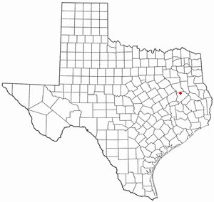
Houston County is a county located in the U.S. state of Texas. As of the 2020 census, its population was 22,066. Its county seat is Crockett. Houston County was one of 46 entirely dry counties in the state of Texas, until voters in a November 2007 special election legalized the sale of alcohol in the county.

<span class="mw-page-title-main">Elkhart, Texas</span> Town in Texas, United States

Elkhart is a town the U.S. state of Texas, in Anderson County. Named for a friendly Native American who assisted the early settlers of the area, Elkhart's population was 1,287 at the 2020 U.S. census.

<span class="mw-page-title-main">Rusk, Texas</span> City in Texas, United States

Rusk is a city and the county seat of Cherokee County in the U.S. state of Texas. At the 2020 United States census, it had a population of 5,285.

<span class="mw-page-title-main">Coleman, Texas</span> City in Texas, United States

Coleman is a town in and the county seat of Coleman County, Texas, United States. As of the 2010 census, its population was 4,709.

<span class="mw-page-title-main">Paducah, Texas</span> Town in Texas, United States

Paducah is a town in Cottle County, Texas, United States. The population was 1,186 at the 2010 census, down from 1,498 in 2000. It is the county seat of Cottle County. It is just south of the Texas Panhandle and east of the Llano Estacado.

<span class="mw-page-title-main">Ozona, Texas</span> Census-designated place in Texas, United States

Ozona is an unincorporated community and census-designated place (CDP) that serves as the county seat of Crockett County, Texas, United States. The population was 3,225 at the time of the 2010 census. Ozona is the only Census Bureau–recognized community in Crockett County, which is named for Colonel Davy Crockett, a hero of the Alamo.

<span class="mw-page-title-main">Honey Grove, Texas</span> City in Texas, United States

Honey Grove is a city in Fannin County, Texas, United States. Honey Grove bills itself as "The Sweetest Town in Texas". The population was 1,668 at the 2010 census.

<span class="mw-page-title-main">Rosenberg, Texas</span> City in Texas, United States

Rosenberg is a city in the U.S. state of Texas, within the Houston–The Woodlands–Sugar Land metropolitan area and Fort Bend County. Rosenberg was named for Henry Von Rosenberg, who emigrated to Texas from Switzerland in 1843. Von Rosenberg was an important figure in the settlement of Fort Bend County and the Gulf Coast region. The population was 38,282 at the 2020 census, up from 30,618 at the 2010 census. The community holds the Fort Bend County fair in October. Rosenberg is adjacent to the city of Richmond, the Fort Bend County seat.

<span class="mw-page-title-main">Fairfield, Texas</span> City in Texas, United States

Fairfield is a city in Freestone County, Texas, United States. The population was 2,850 at the 2020 census, down from 3,094 at the 2000 census. It is the county seat of Freestone County and was founded as such in 1851.

<span class="mw-page-title-main">Pearsall, Texas</span> City in Texas, United States

Pearsall is a city in and the county seat of Frio County, Texas, United States. The population was 9,146 at the 2010 census, up from 7,157 at the 2000 census.

<span class="mw-page-title-main">Pampa, Texas</span> City in Texas, United States

Pampa is a city in Gray County, Texas, United States. Its population was 16,867 as of the 2020 census. Pampa is the county seat of Gray County and is the principal city of the Pampa micropolitan statistical area, which includes both Gray and Roberts Counties. Pampa is named after the Pampas Lowlands in Argentina, Uruguay, and southern Brazil.

<span class="mw-page-title-main">Scottsville, Texas</span> City in Texas, United States

Scottsville is a city in Harrison County, Texas, United States. The population was 376 at the 2010 census, up from 263 at the 2000 census. Scottsville's population in 2020 decreased to 334.

<span class="mw-page-title-main">Grapeland, Texas</span> City in Texas, United States

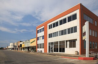
Grapeland is a city in Houston County, Texas, United States. Its population was 1,465 as of the 2020 census.

<span class="mw-page-title-main">Kennard, Texas</span> City in Texas, United States

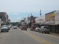
Kennard is a city in Houston County, Texas, United States. Its population was 337 at the 2010 census. The main street is Texas State Highway 7.

<span class="mw-page-title-main">Lovelady, Texas</span> City in Texas, United States

Lovelady is a town in Houston County, Texas, United States. The population was 570 at the 2020 census.

<span class="mw-page-title-main">Anson, Texas</span> City in Texas, United States

Anson is a city in and the county seat of Jones County, Texas, United States. The population was 2,430 at the 2010 census. It is part of the Abilene, Texas metropolitan area. Originally named "Jones City", the town was renamed "Anson" in 1882 in honor of Anson Jones, the last president of the Republic of Texas.

<span class="mw-page-title-main">Karnes City, Texas</span> City in Texas, United States

Karnes City is a city in and county seat of Karnes County, Texas, United States. The population was 3,111 at the 2020 census, up from 3,042 at the 2010 census. The town was named after Henry Karnes of the Texas Revolution. Karnes is 24 miles (39 km) southeast of Floresville and 54 miles (87 km) southeast of San Antonio on U.S. Highway 181.

<span class="mw-page-title-main">Cleveland, Texas</span> City in Texas, United States

Cleveland is a city in the U.S. state of Texas, within the Greater Houston metropolitan area and Liberty County. The population was 7,471 at the 2020 census.

<span class="mw-page-title-main">San Augustine, Texas</span> City in Texas, United States

San Augustine is the county seat city of San Augustine County, Texas, in East Texas, United States. The population was 1,920 at the 2020 census.

<span class="mw-page-title-main">Waller, Texas</span> City in Texas, United States

Waller is a city in Texas, United States, partly in Waller County and partly in Harris County within the Houston–Cypress metropolitan area. Its population was 2,682 at the 2020 U.S. census. The Waller area is located along U.S. Route 290 41 miles (66 km) northwest of downtown Houston.

References

  1. "2019 U.S. Gazetteer Files". United States Census Bureau. Retrieved August 7, 2020.
  2. 1 2 "U.S. Census website". United States Census Bureau . Retrieved January 31, 2008.
  3. "US Board on Geographic Names". United States Geological Survey. October 25, 2007. Retrieved January 31, 2008.
  4. 1 2 "Geographic Identifiers: 2010 Census Summary File 1 (G001): Crockett city, Texas". American Factfinder. U.S. Census Bureau. Archived from the original on February 13, 2020. Retrieved March 15, 2018.
  5. "Find a County". National Association of Counties. Archived from the original on May 31, 2011. Retrieved June 7, 2011.
  6. Gannett, Henry (1905). The Origin of Certain Place Names in the United States. Govt. Pr Off. pp.  96.
  7. 1 2 "TSHA | Gossett, Andrew Edwards". www.tshaonline.org. Retrieved April 29, 2021.
  8. Crockett Texas and Crockett Texas Hotels Motels
  9. "Post Office Location - CROCKETT Archived 2010-08-29 at the Wayback Machine ." United States Postal Service. Retrieved on August 8, 2010.
  10. "Crockett State School Archived 2011-02-20 at the Wayback Machine ." Texas Youth Commission. Retrieved on August 8, 2010.
  11. "TYC Announces Closure of Three Facilities Archived March 5, 2012, at the Wayback Machine ." Texas Youth Commission. Retrieved on July 3, 2011.
  12. "US Gazetteer files: 2010, 2000, and 1990". United States Census Bureau. February 12, 2011. Retrieved April 23, 2011.
  13. "NOWData – NOAA Online Weather Data". National Oceanic and Atmospheric Administration. Retrieved November 12, 2023.
  14. "Summary of Monthly Normals 1991–2020". National Oceanic and Atmospheric Administration. Retrieved November 12, 2023.
  15. "Census of Population and Housing". Census.gov. Retrieved June 4, 2015.
  16. "Explore Census Data". data.census.gov. Retrieved May 25, 2022.
  17. "About the Hispanic Population and its Origin". www.census.gov. Retrieved May 18, 2022.
  18. Comen, Evan. "America's 30 poorest towns". MSN. Retrieved June 19, 2018.
  19. <Kenny Rogers to star in first TV special [ permanent dead link ] Tri City Herald, March 6, 1979
  20. Climate Summary for Crockett, Texas
  1. Note: the US Census treats Hispanic/Latino as an ethnic category. This table excludes Latinos from the racial categories and assigns them to a separate category. Hispanics/Latinos can be of any race. [17]