Dana, Indiana

Last updated

Dana, Indiana
Dana-Maple-Street-in.jpg
Maple Street (SR 71)
Vermillion County Indiana Incorporated and Unincorporated areas Dana Highlighted 1816732.svg
Location of Dana in Vermillion County, Indiana.
Map of Dana, Indiana.svg
Map of Dana
Coordinates: 39°48′24″N87°29′39″W / 39.80667°N 87.49417°W / 39.80667; -87.49417
Country United States
State Indiana
County Vermillion
Township Helt
Established1874
Area
[1]
  Total0.29 sq mi (0.76 km2)
  Land0.29 sq mi (0.76 km2)
  Water0.00 sq mi (0.00 km2)
Elevation
[2]
640 ft (195 m)
Population
 (2020)
  Total555
  Density1,900.68/sq mi (733.89/km2)
Time zone UTC-5 (EST)
  Summer (DST) UTC-5 (EST)
ZIP code
47847
Area code 765
FIPS code 18-16732 [3]
GNIS feature ID 433305

Dana is a town in Helt Township, Vermillion County, Indiana, United States. [4] The population was 555 at the 2020 census. It is primarily a farming community.

Contents

History

Dana was platted in 1874 when the railroad was extended to that point. [5] The town was named for Charles Dana, a railroad promoter. [6] A post office has been in operation at Dana since 1874. [7] Dana was incorporated in 1886. [5] In 1886, Dana was declared a rapidly growing and vibrant community, due to its railroad, businesses, and agriculture. [8]

Geography

Dana is located in the central part of the county, on Indiana State Road 71 less than 0.5 miles (0.80 km) north of U.S. Route 36.

According to the 2010 census, Dana has a total area of 0.29 square miles (0.75 km2), all land. [9]

Demographics

Historical population
CensusPop.Note
1880 183
1890 495170.5%
1900 89380.4%
1910 748−16.2%
1920 88418.2%
1930 859−2.8%
1940 845−1.6%
1950 8541.1%
1960 811−5.0%
1970 720−11.2%
1980 80311.5%
1990 612−23.8%
2000 6628.2%
2010 608−8.2%
2020 555−8.7%
U.S. Decennial Census [10]

2020 census

While 2020 census figures are not finalized, the U.S. Census Bureau estimates that Dana's population has dropped from 608 to 570. [8] Poverty and joblessness remain an issue in the town. [8]

2010 census

As of the census [11] of 2010, there were 608 people, 241 households, and 173 families living in the town. The population density was 2,096.6 inhabitants per square mile (809.5/km2). There were 290 housing units at an average density of 1,000.0 per square mile (386.1/km2). The racial makeup of the town was 97.5% White, 0.2% African American, 0.5% Native American, 0.2% Asian, 0.7% from other races, and 1.0% from two or more races. Hispanic or Latino of any race were 1.3% of the population.

There were 241 households, of which 34.0% had children under the age of 18 living with them, 59.8% were married couples living together, 9.5% had a female householder with no husband present, 2.5% had a male householder with no wife present, and 28.2% were non-families. 25.7% of all households were made up of individuals, and 14.5% had someone living alone who was 65 years of age or older. The average household size was 2.52 and the average family size was 3.00.

The median age in the town was 40.7 years. 24.2% of residents were under the age of 18; 6.8% were between the ages of 18 and 24; 25% were from 25 to 44; 25.4% were from 45 to 64; and 18.6% were 65 years of age or older. The gender makeup of the town was 46.2% male and 53.8% female.

2000 census

As of the census [3] of 2000, there were 662 people, 252 households, and 187 families living in the town. The population density was 2,255.4 inhabitants per square mile (870.8/km2). There were 288 housing units at an average density of 981.2 per square mile (378.8/km2). The racial makeup of the town was 97.58% White, 0.60% African American, 0.30% Asian, 0.76% from other races, and 0.76% from two or more races. Hispanic or Latino of any race were 1.66% of the population.

There were 252 households, out of which 33.7% had children under the age of 18 living with them, 62.7% were married couples living together, 8.7% had a female householder with no husband present, and 25.4% were non-families. 23.0% of all households were made up of individuals, and 9.9% had someone living alone who was 65 years of age or older. The average household size was 2.63 and the average family size was 3.05.

In the town, the population was spread out, with 28.4% under the age of 18, 6.8% from 18 to 24, 28.7% from 25 to 44, 23.9% from 45 to 64, and 12.2% who were 65 years of age or older. The median age was 36 years. For every 100 females, there were 95.9 males. For every 100 females age 18 and over, there were 94.3 males.

The median income for a household in the town was $34,750, and the median income for a family was $38,182. Males had a median income of $30,313 versus $21,875 for females. The per capita income for the town was $15,603. About 6.6% of families and 9.9% of the population were below the poverty line, including 14.4% of those under age 18 and 9.5% of those age 65 or over.

Parks and Recreation

In late 2020, The Tribune-Star reported that Dana is planning a downtown community center that would serve as a hub for resident services and programming for children, families, and senior adults. Dana received a $10,000 grant from the Vermillion County Community Foundation to go toward the project. [8]

Notable people

Famed World War II war correspondent Ernie Pyle was born on a tenant farm near Dana. Pyle won the Pulitzer Prize in 1944 for his Correspondence entry. [12] Bert Shepard, a Major League Baseball pitcher for the Washington Senators who had lost his leg in WWII, was also born in Dana. American author Dana Trent moved to Dana as an infant. [13]

Related Research Articles

<span class="mw-page-title-main">Vermillion County, Indiana</span> County in Indiana, United States

Vermillion County lies in the western part of the U.S. state of Indiana between the Illinois border and the Wabash River. As of the 2020 census, the population was 15,439. The county seat is Newport. It was officially established in 1824 and was the fiftieth Indiana county created. Vermillion County is included in the Terre Haute, Indiana, Metropolitan Statistical Area. The county contains seven incorporated towns with a total population of about 9,900. as well as several unincorporated communities; it is also divided into five townships which provide local services. An interstate highway, two U.S. routes, and five state roads cross the county, as does a major railroad line.

<span class="mw-page-title-main">Utica, Indiana</span> Town in Indiana, United States

Utica is a town in Utica Township, Clark County, Indiana, United States. The population was 776 at the 2010 census.

<span class="mw-page-title-main">Lanesville, Indiana</span> Town in Indiana, United States

Lanesville is a town in Franklin Township, Harrison County, Indiana, United States. The population was 935 at the 2010 census.

<span class="mw-page-title-main">New Middletown, Indiana</span> Town in Indiana, United States

New Middletown is a town in Webster Township, Harrison County, Indiana, United States. The population was 93 at the 2010 census.

<span class="mw-page-title-main">Paragon, Indiana</span> Town in Indiana, United States

Paragon is a town in Ray Township, Morgan County, in the U.S. state of Indiana. The population was 556 at the 2020 census, down from 659 in 2010.

<span class="mw-page-title-main">Bloomingdale, Indiana</span> Town in Indiana, United States

Bloomingdale is a town in Penn Township, Parke County, in the U.S. state of Indiana. The population was 335 at the 2010 census.

<span class="mw-page-title-main">Mecca, Indiana</span> Town in Indiana, United States

Mecca is a town in Wabash Township, Parke County, in the U.S. state of Indiana. The population was 335 at the 2010 census.

<span class="mw-page-title-main">Montezuma, Indiana</span> Town in Indiana, United States

Montezuma is a town in Reserve Township, Parke County, in the U.S. state of Indiana. The population was 1,022 at the 2010 census. It is located approximately 66 miles west of the state capital Indianapolis.

<span class="mw-page-title-main">Rockville, Indiana</span> Town in Indiana, United States

Rockville is a town in Adams Township, Parke County, in the U.S. state of Indiana. The population was 2,607 at the 2010 census. The town is the county seat of Parke County. It is known as "The Covered Bridge Capital of the World".

<span class="mw-page-title-main">Rosedale, Indiana</span> Town in Indiana, United States

Rosedale is a town in Florida Township, Parke County, in the U.S. state of Indiana. The population was 725 at the 2010 census.

<span class="mw-page-title-main">Clear Lake, Indiana</span> Town in Indiana, United States

Clear Lake is a town located in the northeast corner of Steuben County, Indiana, in Clear Lake Township. As such, is the northeasternmost community in the State of Indiana. The population was 339 at the 2010 census.

<span class="mw-page-title-main">Cayuga, Indiana</span> Town in Indiana, United States

Cayuga is a town in Eugene Township, Vermillion County, in the U.S. state of Indiana. The population was 1,162 at the 2010 census.

<span class="mw-page-title-main">Clinton, Indiana</span> City in Indiana, United States

Clinton is a city in Clinton Township, Vermillion County, in the U.S. state of Indiana. The population was 4,893 at the 2010 census.

<span class="mw-page-title-main">Fairview Park, Indiana</span> Town in Indiana, United States

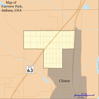
Fairview Park is a town in Clinton Township, Vermillion County, in the U.S. state of Indiana. The population was 1,386 at the 2010 census.

<span class="mw-page-title-main">Newport, Indiana</span> Town in Indiana, United States

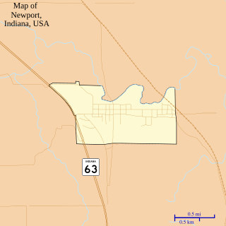
Newport is a town in Vermillion Township, Vermillion County, in the U.S. state of Indiana. The population was 515 at the 2010 census. The town is the county seat of Vermillion County.

<span class="mw-page-title-main">Perrysville, Indiana</span> Town in Indiana, United States

Perrysville is a town in Highland Township, Vermillion County, in the U.S. state of Indiana. The population was 456 at the 2010 census.

<span class="mw-page-title-main">Universal, Indiana</span> Town in Indiana, United States

Universal is a town in Clinton Township, Vermillion County, in the U.S. state of Indiana. The population was 362 at the 2010 census.

<span class="mw-page-title-main">Vermillion, Kansas</span> City in Marshall County, Kansas

Vermillion is a city in Marshall County, Kansas, United States. As of the 2020 census, the population of the city was 76.

<span class="mw-page-title-main">Vermillion, Minnesota</span> City in Minnesota, United States

Vermillion is a city in Dakota County, Minnesota, United States. The population was 441 at the 2020 census.

<span class="mw-page-title-main">Hayesville, Ohio</span> Village in Ohio, United States

Hayesville is a village in Vermillion Township, Ashland County, Ohio, United States. The population was 447 at the 2020 census.

References

  1. "2020 U.S. Gazetteer Files". United States Census Bureau. Retrieved March 16, 2022.
  2. "US Board on Geographic Names". United States Geological Survey. October 25, 2007. Retrieved January 31, 2008.
  3. 1 2 "U.S. Census website". United States Census Bureau . Retrieved January 31, 2008.
  4. "Dana, Indiana". Geographic Names Information System . United States Geological Survey, United States Department of the Interior . Retrieved July 15, 2016.
  5. 1 2 History of Parke and Vermillion Counties, Indiana. B.F. Bowen & Cos. 1913. p. 415.
  6. Baker, Ronald L. (October 1995). From Needmore to Prosperity: Hoosier Place Names in Folklore and History . Indiana University Press. p.  109. ISBN   978-0-253-32866-3. .The name honors Charles Dana, a stockholder...
  7. "Vermillion County". Jim Forte Postal History. Archived from the original on October 1, 2015. Retrieved October 1, 2015.
  8. 1 2 3 4 Tribune-Star, Mark Bennett. "Mark Bennett: Dana envisions a new community center as hub of activities, services". Terre Haute Tribune-Star. Retrieved June 9, 2021.
  9. "G001 - Geographic Identifiers - 2010 Census Summary File 1". United States Census Bureau. Archived from the original on February 13, 2020. Retrieved July 16, 2015.
  10. "Census of Population and Housing". Census.gov. Retrieved June 4, 2015.
  11. "U.S. Census website". United States Census Bureau . Retrieved December 11, 2012.
  12. "The GIs' favorite correspondent". www.pulitzer.org. Archived from the original on August 31, 2016. Retrieved June 9, 2021.
  13. Tribune-Star, Mark Bennett. "'Breaking Good' in rural America". Terre Haute Tribune-Star. Retrieved October 10, 2022.