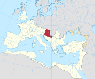
Pannonia was a province of the Roman Empire bounded on the north and east by the Danube, coterminous westward with Noricum and upper Italy, and southward with Dalmatia and upper Moesia. Pannonia was located in the territory that is now western Hungary, western Slovakia, eastern Austria, northern Croatia, north-western Serbia, northern Slovenia, and northern Bosnia and Herzegovina.
Moesia was an ancient region and later Roman province situated in the Balkans south of the Danube River, which included most of the territory of modern eastern Serbia, Kosovo, north-eastern Albania, northern parts of North Macedonia, Northern Bulgaria, Romanian Dobruja and small parts of Southern Ukraine.

Līmes is a modern term used primarily for the Germanic border defence or delimiting system of Ancient Rome marking the borders of the Roman Empire, but it was not used by the Romans for that purpose. The term has been extended to refer to the frontier defences in other parts of the empire, such as in the east and in Africa.

Germania, also called Magna Germania, Germania Libera, or Germanic Barbaricum to distinguish it from the Roman province of the same name, was a large historical region in north-central Europe during the Roman era, which was associated by Roman authors with the Germanic peoples. The region stretched roughly from the Middle and Lower Rhine in the west to the Vistula in the east. It also extended as far south as the Upper and Middle Danube and Pannonia, and to the known parts of Scandinavia in the north. Archaeologically, these peoples correspond roughly to the Roman Iron Age of those regions. While apparently dominated by Germanic peoples, Magna Germania was also inhabited by other Indo-European peoples.

The Roman provinces were the administrative regions of Ancient Rome outside Roman Italy that were controlled by the Romans under the Roman Republic and later the Roman Empire. Each province was ruled by a Roman appointed as governor.

The Carpi or Carpiani were a Dacian tribe that resided in the eastern parts of modern Romania in the historical region of Moldavia from no later than c. AD 140 and until at least AD 318.
In Roman literature of the early 1st century CE, the Moesi appear as a Paleo-Balkan people who lived in the region around the River Timok to the south of the Danube. The Moesi do not appear in ancient sources before Augustus's death in 14 CE and are mentioned only by three authors: Ovid, Strabo and Livy. Recent research suggests that a Paleo-Balkan people known as the Moesi never actually existed but the name was transplanted from Asia Minor Mysians to the Balkans by the Romans as an alternative name for the people who lived in the later province of Moesia Superior as Dardani communities. This decision in Roman literature is linked to the appropriation of the name Dardani in official Roman ideological discourse as Trojan ancestors of the Romans and the creation of a fictive name for the actual Dardani who were seen as barbarians and antagonists of Rome in antiquity.
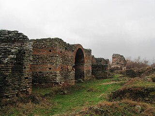
Justiniana Prima was an Eastern Roman city that existed from 535 to 615, and currently an archaeological site, known as or Caričin Grad, near modern Lebane in the Leskovac region, southern Serbia. It was founded by Emperor Justinian I (527-565) and served as the metropolitan seat of the then newly founded Archbishopric of Justiniana Prima, which became the main church administrative body of the central and western Balkans with jurisdiction from Praevalitana to Dacia Ripensis. Justinian Prima was originally designed to become the capital of the prefecture of Illyricum, but for reasons likely related with its status near the Roman frontiers of the 6th century CE, Thessaloniki was preferred. It was abandoned less than 100 years after its foundation.
Quintus Marcius Turbo was prefect of the Praetorian Guard and a close friend and military advisor to both emperor Trajan and Hadrian during the early 2nd century.

Domitian's Dacian War was a conflict between the Roman Empire and the Dacian Kingdom, which had invaded the province of Moesia. The war occurred during the reign of the Roman emperor Domitian, in the years 86–88 AD.

The Diocese of Dacia was a diocese of the later Roman Empire, in the area of modern western Bulgaria, central Serbia, Montenegro, northern Albania and northern North Macedonia. It was subordinate to the Praetorian prefecture of Illyricum. Its capital was at Serdica.

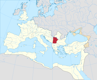
Dardania was a Roman province in the Central Balkans, initially an unofficial region in Moesia (87–284), and then a province administratively part of the Diocese of Moesia (293–337). It was named after the tribe of the Dardani who inhabited the region in classical antiquity prior to the Roman conquest.
The quaestura exercitus was an administrative district of the Eastern Roman Empire with a seat in Odessus established by Emperor Justinian I on May 18, 536.

The Moesian Limes is the modern term given to a collection of Roman fortifications between the Black Sea shore and Pannonia, present-day Hungary, consisting primarily of forts along the Danube to protect the Roman provinces of Upper and Lower Moesia south of the river.

Much of the territory of the modern state of Serbia was part of the Roman Empire and later the Eastern Roman Empire. In particular, the region of Central Serbia was under Roman rule for about 800 years, starting from the 1st century BC, interrupted by the arrival of the Slavs into the Balkans during the 6th century, but continued after fall of the First Bulgarian Empire in the early 11th century and permanently ended with the rise of the Second Bulgarian Empire in the late 12th century. The territories were administratively divided into the provinces of Moesia, Pannonia and Dardania. Moesia Superior roughly corresponds to modern Serbia proper; Pannonia Inferior included the eastern part of Serbia proper; Dardania included the western part of Serbia proper. After its reconquest from the Bulgarians by Emperor Basil II in 1018, it was reorganized into the Theme of Bulgaria.
Roman Dacia was a province of the Roman Empire from 106 to 271–275 AD. Its territory consisted of what are now the regions of Oltenia, Transylvania and Banat. During Roman rule, it was organized as an imperial province on the borders of the empire. It is estimated that the population of Roman Dacia ranged from 650,000 to 1,200,000. It was conquered by Trajan (98–117) after two campaigns that devastated the Dacian Kingdom of Decebalus. However, the Romans did not occupy its entirety; Crișana, Maramureș, and most of Moldavia remained under the Free Dacians.

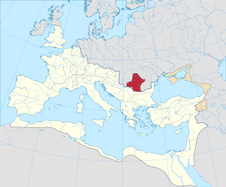
Moesia Prima was a frontier province of the late Roman Empire, situated in the central parts of present-day Serbia, along the south bank of the Danube River. Provincial capital was Viminacium, near modern Kostolac in Serbia).

In Roman Dacia, an estimated 50,000 troops were stationed at its height.
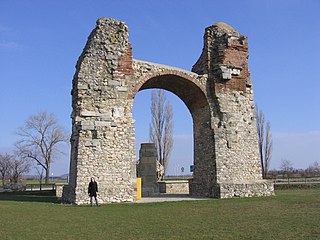
The Pannonian Limes is that part of the old Roman fortified frontier known as the Danubian Limes that runs for approximately 420 km (260 mi) from the Roman camp of Klosterneuburg in the Vienna Basin in Austria to the castrum in Singidunum (Belgrade) in present-day Serbia. The garrisons of these camps protected the Pannonian provinces against attacks from the north from the time of Augustus (31 BC–14 AD) to the beginning of the 5th century. In places this section of the Roman limes also crossed the river into the territory of the barbarians (Barbaricum).
The timeline of Hungarian history lists the important historical events that took place in the territory of Hungary or are closely connected to the history of the country. The subsequent events encompass the timeline spanning from Classical Antiquity through the High Middle Ages, specifically up to the 1030s.
