David Alt | |
|---|---|
| Born | Sept 17, 1933 St. Louis, Missouri, United States |
| Died | April 26, 2015 (aged 81) Missoula, Montana, United States |
| Occupation(s) | Author, geologist |
David Alt (September 17, 1933 - April 26, 2015) was an American geologist and author.
David Alt | |
|---|---|
| Born | Sept 17, 1933 St. Louis, Missouri, United States |
| Died | April 26, 2015 (aged 81) Missoula, Montana, United States |
| Occupation(s) | Author, geologist |
David Alt (September 17, 1933 - April 26, 2015) was an American geologist and author.
Alt was the author of more than thirty books, including several titles in the "Roadside Geology" series published by Mountain Press. [1] [2] [3]
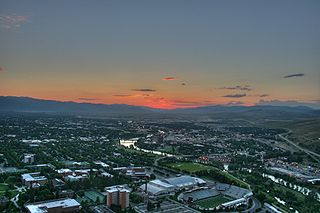
He earned his Ph.D. in 1961 from the University of Texas, and joined the Department of Geology at The University of Montana in Missoula, MT in 1965. [4] He became professor Emeritus at The University of Montana in 2002. [4]
He died on April 26, 2015, in Missoula, MT. [5]
Alt helped to interpret and explain to a wide audience the cataclysmic glacial Missoula Floods through articles and his book Glacial Lake Missoula and Its Humongous Floods (Mountain Press, 2001. ISBN 978-0878424153). [6] [7] [8]

The Missoula floods were cataclysmic glacial lake outburst floods that swept periodically across eastern Washington and down the Columbia River Gorge at the end of the last ice age. These floods were the result of periodic sudden ruptures of the ice dam on the Clark Fork River that created Glacial Lake Missoula. After each ice dam rupture, the waters of the lake would rush down the Clark Fork and the Columbia River, flooding much of eastern Washington and the Willamette Valley in western Oregon. After the lake drained, the ice would reform, creating Glacial Lake Missoula again.

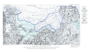
Lake Missoula was a prehistoric proglacial lake in western Montana that existed periodically at the end of the last ice age between 15,000 and 13,000 years ago. The lake measured about 7,770 square kilometres (3,000 sq mi) and contained about 2,100 cubic kilometres (500 cu mi) of water, half the volume of Lake Michigan.
Glacial Lake Wisconsin was a prehistoric proglacial lake that existed from approximately 18,000 to 14,000 years ago, at the end of the last ice age, in the central part of present-day Wisconsin in the United States.

Grand Coulee is an ancient river bed in the U.S. state of Washington. This National Natural Landmark stretches for about 60 miles (100 km) southwest from Grand Coulee Dam to Soap Lake, being bisected by Dry Falls into the Upper and Lower Grand Coulee.

Flathead Lake is a large natural lake in northwest Montana, United States.

The Palouse River is a tributary of the Snake River in Washington and Idaho, in the northwest United States. It flows for 167 miles (269 km) southwestwards, primarily through the Palouse region of southeastern Washington. It is part of the Columbia River Basin, as the Snake River is a tributary of the Columbia River.

Dry Falls is a 3.5-mile-long (5.6 km) scalloped precipice with four major alcoves, in central Washington scablands. This cataract complex is on the opposite side of the Upper Grand Coulee from the Columbia River, and at the head of the Lower Grand Coulee, northern end of Lenore Canyon. According to the current geological model, catastrophic flooding channeled water at 65 miles per hour through the Upper Grand Coulee and over this 400-foot (120 m) rock face at the end of the last glaciation. It is estimated that the falls were five times the width of Niagara Falls, with ten times the flow of all the current rivers in the world combined.

The Touchet Formation or Touchet beds consist of well-bedded, coarse to fine sand and silt which overlays local bedrock composed of Neogene basalt of the Columbia River Basalt Group in south-central Washington and north-central Oregon. The beds consist of more than 40 to 62 distinct rhythmites – horizontal layers of sediment, each clearly demarcated from the layer below. These Touchet beds are often covered by windblown loess which were deposited later; the number of layers varies with location. The beds vary in thickness from 330 ft (100 m) at lower elevations where a number of layers can be found to a few extremely thin layers at the maximum elevation where they are observed.

Lake Lewis was a large transient lake in the Pacific Northwest region of North America, formed by periodic Missoula Floods along the Columbia River paleocourse between 21,000 and 16,000 years ago.
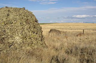
Sims Corner Eskers and Kames National Natural Landmark of Douglas County, Washington and nearby McNeil Canyon Haystack Rocks and Boulder Park natural landmarks contain excellent examples of Pleistocene glacial landforms. Sims Corner Eskers and Kames National Natural Landmark includes classic examples of ice stagnation landforms such as glacial erratics, terminal moraines, eskers, and kames. It is located on the Waterville Plateau of the Columbia Plateau in north central Washington state in the United States.

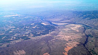
Moses Coulee is a canyon in the Waterville plateau region of Douglas County, Washington. Moses Coulee is the second-largest and westernmost canyon of the Channeled Scablands, located about 30 kilometres (19 mi) to the west of the larger Grand Coulee. This water channel is now dry, but during glacial periods, large outburst floods with discharges greater than 600,000 m3/s (21,000,000 cu ft/s) carved the channel. While it's clear that megafloods from Glacial Lake Missoula passed through and contributed to the erosion of Moses Coulee, the origins of the coulee are less clear. Some researchers propose that floods from glacial Lake Missoula formed Moses Coulee, while others suggest that subglacial floods from the Okanogan Lobe incised the canyon. The mouth of Moses Coulee discharges into the Columbia River.
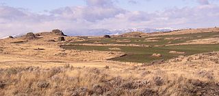
The Withrow Moraine and Jameson Lake Drumlin Field is a National Park Service–designated privately owned National Natural Landmark located in Douglas County, Washington state, United States. Withrow Moraine is the only Ice Age terminal moraine on the Waterville Plateau section of the Columbia Plateau. The drumlin field includes excellent examples of glacially-formed elongated hills.
The Ice Age Floods National Geologic Trail is a network of routes connecting natural sites and facilities that provide interpretation of the geological consequences of the Glacial Lake Missoula floods of the last glacial period that occurred about 18,000 to 15,000 years ago. It includes sites in Washington, Oregon, Idaho, and Montana. It was designated as the first National Geologic Trail in the United States in 2009.
Lake Condon was a temporary lake in the Pacific Northwest region of North America, formed periodically by the Missoula Floods from 15,000 to 13,000 BC.
Lake Great Falls was a prehistoric proglacial lake which existed in what is now central Montana in the United States between 15,000 BCE and 11,000 BCE. Centered on the modern city of Great Falls, Montana, Glacial Lake Great Falls extended as far north as Cut Bank, Montana, and as far south as Holter Lake. At present-day Great Falls, the Glacial Lake Great Falls reached a depth of 600 feet.
Giant current ripples, Giant gravel bars, Gravel dunes or GCR's, are a form of subaqueous dune. They are active channel topographic forms up to 20 m high, which occur within near-thalweg areas of the main outflow routes created by glacial lake outburst floods. Giant current ripple marks are large scale analogues of small current ripples formed by sand in streams. Giant current ripple marks are important features associated with scablands. As a landscape component, they are found in several areas that were previously in the vicinity of large glacial lakes.

New England is a region in the North Eastern United States consisting of the states Rhode Island, Connecticut, Massachusetts, New Hampshire, Vermont, and Maine. Most of New England consists geologically of volcanic island arcs that accreted onto the eastern edge of the Laurentian Craton in prehistoric times. Much of the bedrock found in New England is heavily metamorphosed due to the numerous mountain building events that occurred in the region. These events culminated in the formation of Pangaea; the coastline as it exists today was created by rifting during the Jurassic and Cretaceous periods. The most recent rock layers are glacial conglomerates.

Mount Jumbo, also called Mount Loyola by some locals, is a mountain that overlooks the city of Missoula in the U.S. state of Montana. The mountain is northeast of the city's downtown and, in its majority, is publicly owned. In 1996, Jumbo was purchased from private landowners and protected from development. Funding for this purchase came from an open space bond, federal and non-profit agencies and thousands of local contributors. Additional land parcels have been purchased since then, increasing the easement to 1,800 acres (730 ha).

Mount Sentinel, originally known as "Mount Woody," is a small mountain located immediately east of the University of Montana in Missoula, Montana. At a height of 1,958 feet and an elevation of 5,158 feet (1,572 m), Mount Sentinel also features the hillside letter "M", a large concrete structure 620 feet (189 m) up its western face.
The history of Missoula, Montana begins as early as 12,000 years ago with the end of the region's glacial lake period with western exploration dating back to the Lewis and Clark Expedition of 1804–1806. The first permanent settlement was founded in 1860.
{{cite web}}: |last= has generic name (help)