
A geographic information system (GIS) consists of integrated computer hardware and software that store, manage, analyze, edit, output, and visualize geographic data. Much of this often happens within a spatial database, however, this is not essential to meet the definition of a GIS. In a broader sense, one may consider such a system also to include human users and support staff, procedures and workflows, the body of knowledge of relevant concepts and methods, and institutional organizations.
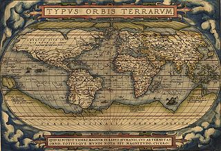
Theatrum Orbis Terrarum is considered to be the first true modern atlas. Written by Abraham Ortelius, strongly encouraged by Gillis Hooftman and originally printed on 20 May 1570 in Antwerp, it consisted of a collection of uniform map sheets and supporting text bound to form a book for which copper printing plates were specifically engraved. The Ortelius atlas is sometimes referred to as the summary of sixteenth-century cartography. The publication of the Theatrum Orbis Terrarum (1570) is often considered as the official beginning of the Golden Age of Netherlandish cartography.

The National Digital Library Program (NDLP) is a project by the United States Library of Congress to assemble a digital library of reproductions of primary source materials to support the study of the history and culture of the United States. The NDLP brought online 24 million books and documents from the Library of Congress and other research institutions.

Sanborn maps are detailed maps of U.S. cities and towns in the 19th and 20th centuries. Originally published by The Sanborn Map Company (Sanborn), the maps were created to allow fire insurance companies to assess their total liability in urbanized areas of the United States. Since they contain detailed information about properties and individual buildings in approximately 12,000 U.S. cities and towns, Sanborn maps are valuable for documenting changes in the built environment of American cities over many decades.

The National Széchényi Library (OSZK) is a library in Budapest, Hungary, located in Buda Castle. It is one of two Hungarian national libraries, the other being University of Debrecen Library.

David Rumsey is an American map collector and the founder of the David Rumsey Map Collection. He is also the president of Cartography Associates.

The Saxon State and University Library Dresden, abbreviated SLUB Dresden, is located in Dresden, Germany. It is both the regional library for the German State of Saxony as well as the academic library for the Dresden University of Technology. It was created in 1996 through the merger of the Saxon State Library (SLB) and the University Library Dresden (UB). The seemingly redundant name is to show that the library brings both these institutional traditions together.

Terrain cartography or relief mapping is the depiction of the shape of the surface of the Earth on a map, using one or more of several techniques that have been developed. Terrain or relief is an essential aspect of physical geography, and as such its portrayal presents a central problem in cartographic design, and more recently geographic information systems and geovisualization.

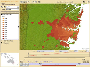
Web mapping or an online mapping is the process of using, creating, and distributing maps on the World Wide Web, usually through the use of Web geographic information systems. A web map or an online map is both served and consumed, thus, web mapping is more than just web cartography, it is a service where consumers may choose what the map will show.

The Biblioteca Nacional de Portugal is the Portuguese national library.
National and University Library in Zagreb (NSK) is the national library of Croatia and central library of the University of Zagreb.
Critical cartography is a set of mapping practices and methods of analysis grounded in critical theory, specifically the thesis that maps reflect and perpetuate relations of power, typically in favor of a society's dominant group. Critical cartographers aim to reveal the “‘hidden agendas of cartography’ as tools of socio-spatial power”. While the term "critical cartography" often refers to a body of theoretical literature, critical cartographers also call for practical applications of critical cartographic theory, such as counter-mapping, participatory mapping, and neogeography.
The Stanford University Libraries Digital Image Collections is an online collection of digital images called Image Gallery, maintained by the Stanford University Libraries. The site provides access to over 50,000 digital images scanned from collections owned by the Stanford Libraries. Users can search image metadata, browse collections, and view images at high resolutions.
TimeMap Java is an open-source web mapping application, which was one of the first such applications to introduce generic time filtering and map animation on the web. TMJava is a comprehensive Java mapping applet which can run as a standalone application with local data, on a web site or as a two tier application with a backend server and independent metadata clearinghouse, supporting distributed data sources.
The Water Resources Collections and Archives (WRCA), formerly known as the Water Resources Center Archives, is an archive with unpublished manuscript collections and a library with published materials. It was established to collect unique, hard-to-find, technical report materials pertaining to all aspects of water resources and supply in California and the American West. Located on the campus of the University of California Riverside (UCR), it is jointly administered by the UCR College of Natural and Agricultural Sciences (CNAS) and the UCR Libraries. WRCA was part of the University of California Center for Water Resources (WRC) that was established and funded in 1957 by a special act of the California State Legislature and was designated the California Water Research Institute by a federal act in 1964.

A map collection or map library is a storage facility for maps, usually in a library, archive, or museum, or at a map publisher or public-benefit corporation, and the maps and other cartographic items stored within that facility.

D-Scribe Digital Publishing is an open access electronic publishing program of the University Library System (ULS) of the University of Pittsburgh. It comprises over 100 thematic collections that together contain over 100,000 digital objects. This content, most of which is available through open access, includes both digitized versions of materials from the collections of the University of Pittsburgh and other local institutions as well as original 'born-electronic' content actively contributed by scholars worldwide. D-Scribe includes such items as photographs, maps, books, journal articles, dissertations, government documents, and technical reports, along with over 745 previously out-of-print titles published by the University of Pittsburgh Press. The digital publishing efforts of the University Library System began in 1998 and have won praise for their innovation from the leadership at the Association of Research Libraries and peer institutions.

The Stanford University Libraries (SUL), formerly known as "Stanford University Libraries and Academic Information Resources" ("SULAIR"), is the library system of Stanford University in California. It encompasses more than 24 libraries in all. Several academic departments and some residences also have their own libraries.
Kären Esther Wigen is an American historian, geographer, author and educator. She is the Frances and Charles Field Professor of history at Stanford University.
The cartography of the region of Palestine, also known as cartography of the Holy Land and cartography of the Land of Israel, is the creation, editing, processing and printing of maps of the region of Palestine from ancient times until the rise of modern surveying techniques. For several centuries during the Middle Ages it was the most prominent subject in all of cartography, and it has been described as an "obsessive subject of map art".
