DeWitt, Iowa

Last updated

DeWitt, Iowa
DeWitt, Iowa (21219764543).jpg
Aerial view of DeWitt
Clinton County Iowa Incorporated and Unincorporated areas De Witt Highlighted.svg
Location of DeWitt, Iowa
Coordinates: 41°49′22″N90°32′34″W / 41.82278°N 90.54278°W / 41.82278; -90.54278
Country Flag of the United States.svg  United States
State Flag of Iowa.svg  Iowa
County Clinton
Area
[1]
  Total6.23 sq mi (16.12 km2)
  Land6.22 sq mi (16.11 km2)
  Water0.00 sq mi (0.01 km2)
Elevation
709 ft (216 m)
Population
 (2020)
  Total5,514
  Density886.21/sq mi (342.17/km2)
Time zone UTC-6 (Central (CST))
  Summer (DST) UTC-5 (CDT)
ZIP code
52742
Area code 563
FIPS code 19-21180
GNIS feature ID0455826
Website www.cityofdewittiowa.org

DeWitt [lower-alpha 1] is a city in Clinton County, Iowa, United States. The population was 5,514 at the time of the 2020 census, which represented a 9.2% increase over that of 2000, making it the fastest growing city in Clinton County. [3]

Contents

History

Main Street, 1908 FI0007836.jpg
Main Street, 1908
Buildings along Sixth Avenue DeWitt, Iowa.JPG
Buildings along Sixth Avenue

DeWitt was platted in 1836. [4] The city started under the name Vandenburg, but was later [5] named after DeWitt Clinton (1769–1828), an early American politician who served as United States Senator and seventh Governor of New York. [6]

Ralph Waldo Emerson gave a lyceum lecture at DeWitt in January 1866. [7]

Geography

DeWitt is located at 41°49′22″N90°32′34″W / 41.82278°N 90.54278°W / 41.82278; -90.54278 (41.822684, -90.542643). [8]

According to the United States Census Bureau, the city has a total area of 5.98 square miles (15.49 km2), all land. [9]

Demographics

Historical population
CensusPop.Note
1870 1,749
1880 1,608−8.1%
1890 1,359−15.5%
1900 1,3831.8%
1910 1,65419.6%
1920 1,84911.8%
1930 2,04110.4%
1940 2,2058.0%
1950 2,64419.9%
1960 3,22421.9%
1970 3,64713.1%
1980 4,51223.7%
1990 4,5140.0%
2000 5,04911.9%
2010 5,3225.4%
2020 5,5143.6%
U.S. Decennial Census [10] [3]
The population of DeWitt, Iowa from US census data DeWittIowaPopPlot.png
The population of DeWitt, Iowa from US census data

2010 census

As of the census [11] of 2010, there were 5,322 people, 2,208 households, and 1,415 families residing in the city. The population density was 890.0 inhabitants per square mile (343.6/km2). There were 2,306 housing units at an average density of 385.6 per square mile (148.9/km2). The racial makeup of the city was 97.1% White, 0.8% African American, 0.1% Native American, 0.4% Asian, 0.2% from other races, and 1.5% from two or more races. Hispanic or Latino of any race were 1.9% of the population.

There were 2,208 households, of which 32.4% had children under the age of 18 living with them, 50.9% were married couples living together, 10.2% had a female householder with no husband present, 3.0% had a male householder with no wife present, and 35.9% were non-families. 31.5% of all households were made up of individuals, and 15.9% had someone living alone who was 65 years of age or older. The average household size was 2.37 and the average family size was 2.99.

The median age in the city was 39.7 years. 25.3% of residents were under the age of 18; 7.4% were between the ages of 18 and 24; 24.1% were from 25 to 44; 26% were from 45 to 64; and 17.2% were 65 years of age or older. The gender makeup of the city was 47.4% male and 52.6% female.

The median income for a household in the city was $44,720, and the median income for a family was $54,063. Males had a median income of $37,951 versus $25,457 for females. The per capita income for the city was $19,717. About 2.8% of families and 6.2% of the population were below the poverty line, including 4.1% of those under age 18 and 10.1% of those age 65 or over.

Government

DeWitt is governed by a mayor and five-member council. The mayor is Steve Hasenmiller. [12]

Railroads

DeWitt is served by the Union Pacific along the south side on tracks originally built by the Chicago and Northwestern railroad. Until 1971, the Milwaukee Road entered DeWitt from the north and ran along 7th Avenue before crossing the tracks of the former Chicago & Northwestern into Scott County. The tracks between DeWitt and Eldridge Junction were abandoned in 1931. [13] The Milwaukee Road rail between Maquoketa and DeWitt was abandoned by 1970. Several buildings along 7th Avenue still show signs of former rail loading and unloading uses. These include a former paper box factory (now apartments) at the northwest corner of 7th Avenue and 7th Street as well as various sheds and elevator buildings between 5th and 7th Streets. What had served as the Chicago & Northwestern's Depot was destroyed by fire circa 1969 and never rebuilt. The depot for the Milwaukee Road's Depot was at the northeast corner of 7th Avenue and 7th Street. It was converted into commercial use, but has since been demolished.

Area highways

DeWitt is served by U.S. Highways 30 & 61. At one time the highways met at the northwest corner of the City Park to the north of the city center business district. By 1980 both highways were moved to new alignments around the south and west sides of DeWitt, first suggested in a plan from the early 1960s.

Education

DeWitt is home to the Central DeWitt Community School District. In addition to DeWitt, the nearby cities of Grand Mound, Low Moor, and Welton are also a part the school district. [14] It was previously known as the Central Clinton Community School District until July 1, 2014. [15]

St. Joseph Catholic Church operates a K-8 school. The Junior and High School portions was closed in the 1960s. The mascot for St. Joseph School is the Eagle.

Frances Banta Waggoner Community Library is the local community library. [16]

Media

The DeWitt Observer serves as DeWitt's primary local newspaper. In addition to DeWitt, The Observer also serves much of rural eastern Clinton County. [17]

Notable people

Notes

Related Research Articles

<span class="mw-page-title-main">DeWitt County, Illinois</span> County in Illinois, United States

DeWitt County is a county located in the U.S. state of Illinois. As of the 2020 census, the population was 15,516. Its county seat is Clinton. The county was formed on March 1, 1839, from Macon and McLean counties. The county was named in honor of the seventh Governor of New York State, DeWitt Clinton.

<span class="mw-page-title-main">Clinton County, Iowa</span> County in Iowa, United States

Clinton County is a county located in the U.S. state of Iowa. As of the 2020 census, the population was 46,460. Its county seat is Clinton. Its name is in honor of the seventh Governor of New York State, DeWitt Clinton.

<span class="mw-page-title-main">Clinton County, Michigan</span> County in Michigan, United States

Clinton County is a county in the U.S. state of Michigan. As of the 2020 Census, the population was 79,128. The county seat is St. Johns. The county was created in 1831 and organized in 1839. It is named after early American politician DeWitt Clinton. Clinton County is included in the Lansing-East Lansing, MI Metropolitan Statistical Area.

<span class="mw-page-title-main">DeWitt, Arkansas</span> City in Arkansas, United States

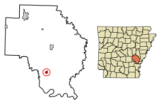
DeWitt is the second largest city in Arkansas County, Arkansas, United States, which also serves as the county seat of the southern district of Arkansas County. Population was 3,292 at the time of the 2010 census. The city is located on the Arkansas Grand Prairie, known for rice farming and duck hunting. DeWitt is home to the DeWitt School District and the DeWitt Municipal Airport.

<span class="mw-page-title-main">Gillett, Arkansas</span> City in Arkansas, United States

Gillett is a city in Arkansas County, Arkansas, United States. Its population was 691 at the 2010 census. Gillett is the home of the annual Gillett Coon Supper. The Arkansas Post National Memorial is located southeast of the town.

<span class="mw-page-title-main">Clinton, Illinois</span> City in Illinois, United States

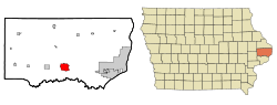
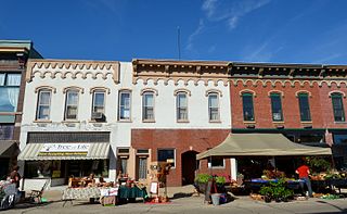
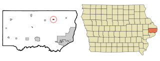
Clinton is the largest city in DeWitt County, Illinois, United States. The population was 7,004 at the 2020 census. It is the county seat of DeWitt County.

<span class="mw-page-title-main">Fulton, Illinois</span> Place in Illinois, United States

Fulton is a city in Whiteside County, Illinois, United States. The population was 3,481 at the 2010 census, down from 3,881 in 2000. Fulton is located across the Mississippi River from Clinton, Iowa.

<span class="mw-page-title-main">Marcus, Iowa</span> City in Iowa, United States

Marcus is a city in Cherokee County, Iowa, United States. The population was 1,079 at the time of the 2020 census.

<span class="mw-page-title-main">Andover, Iowa</span> City in Iowa, United States

Andover is a city in Clinton County, Iowa, United States. The population was 109 at the 2020 census.

<span class="mw-page-title-main">Camanche, Iowa</span> City in Iowa, United States

Camanche is a city in Clinton County, Iowa, United States, on the Mississippi River. The population was 4,570 at the time of the 2020 census.

<span class="mw-page-title-main">Delmar, Iowa</span> City in Iowa, United States

Delmar is a city in Clinton County, Iowa, United States. The population was 542 at the time of the 2020 census.

<span class="mw-page-title-main">Goose Lake, Iowa</span> City in Iowa, United States

Goose Lake is a city in Clinton County, Iowa, United States. The population was 239 at the time of the 2020 census.

<span class="mw-page-title-main">Grand Mound, Iowa</span> City in Iowa, United States

Grand Mound is a city in Clinton County, Iowa, United States. The population was 615 at the time of the 2020 census.

<span class="mw-page-title-main">Low Moor, Iowa</span> City in Iowa, United States

Low Moor is a city in Clinton County, Iowa, United States. The population was 250 at the time of the 2020 census.

<span class="mw-page-title-main">Welton, Iowa</span> City in Iowa, United States

Welton is a city in Clinton County, Iowa, United States. The population was 121 at the time of the 2020 census.

<span class="mw-page-title-main">Wheatland, Iowa</span> City in Iowa, United States

Wheatland is a city in Clinton County, Iowa, United States. The population was 775 at the time of the 2020 census.

<span class="mw-page-title-main">Leon, Iowa</span> City in Iowa, United States

Leon is a city in Decatur County, Iowa, United States. The population was 1,822 at the time of the 2020 census. It is the county seat of Decatur County.

<span class="mw-page-title-main">Colo, Iowa</span> City in Iowa, United States

Colo is a city in Story County, Iowa, United States. The population was 845 at the 2020 census. The Lincoln Highway and Jefferson Highway both pass through Colo. It is part of the Ames, Iowa Metropolitan Statistical Area, which is a part of the larger Ames-Boone, Iowa Combined Statistical Area.

<span class="mw-page-title-main">DeWitt, Michigan</span> City in Michigan, United States

DeWitt is a city in Clinton County in the U.S. state of Michigan. The population was 4,776 at the 2020 census. The city is located north of Interstate 69 and west of U.S. Route 127, just north of the city of Lansing.

<span class="mw-page-title-main">DeWitt Charter Township, Michigan</span> Charter township in Michigan, United States

DeWitt Charter Township is a charter township of Clinton County in the U.S. state of Michigan. The population was 14,321 at the 2010 census, which was an increase from 12,143 at the 2000 census.

References

  1. "2020 U.S. Gazetteer Files". United States Census Bureau. Retrieved March 16, 2022.
  2. Sherman, Barney (September 14, 2017). "Iowa Place Names: A-E". Iowa Public Radio. Retrieved June 9, 2021.
  3. 1 2 "2020 Census State Redistricting Data". census.gov. United states Census Bureau. Retrieved August 12, 2021.
  4. Wolfe, Patrick B. (1911). Wolfe's History of Clinton County, Iowa, Volume 1. B. F. Bowen. pp.  311.
  5. Pratt, LeRoy. "The Counties and Courthouses of Iowa". Clinton County IaGenWeb. IAGenWeb. Archived from the original on September 9, 2004. Retrieved May 24, 2015.
  6. Chicago and North Western Railway Company (1908). A History of the Origin of the Place Names Connected with the Chicago & North Western and Chicago, St. Paul, Minneapolis & Omaha Railways. p. 64.
  7. Tom F. Wright (2013). The Cosmopolitan Lyceum: Lecture Culture and the Globe in Nineteenth-Century America. University of Massachusetts Press. p. 7.
  8. "US Gazetteer files: 2010, 2000, and 1990". United States Census Bureau. February 12, 2011. Retrieved April 23, 2011.
  9. "US Gazetteer files 2010". United States Census Bureau. Archived from the original on July 2, 2012. Retrieved May 11, 2012.
  10. "Census of Population and Housing". Census.gov. Retrieved June 4, 2015.
  11. "U.S. Census website". United States Census Bureau . Retrieved May 11, 2012.
  12. "Mayor & Council".
  13. Carpenter, Richard C. (2003). A Railroad Atlas of the United States in 1946. ISBN   9781421401461.
  14. "Central Community School District Home Page". Archived from the original on July 24, 2012. Retrieved December 22, 2008.
  15. "REORGANIZATION & DISSOLUTION ACTIONS SINCE 1965-66 Archived 2019-02-09 at the Wayback Machine ." Iowa Department of Education. Retrieved on July 20, 2018.
  16. Home. Frances Banta Waggoner Community Library. Retrieved on November 9, 2018.
  17. The DeWitt Observer