Deep Creek Railroad

Last updated
Route 1931 Deep Creek Railroad.jpg
Route 1931

The Deep Creek Railroad is a defunct railroad company that constructed and operated a line between Wendover and Gold Hill, Utah, a distance of about 45 miles. It was constructed in 1917 to serve a mining district in the Gold Hill vicinity and existed for 22 years before succumbing to perennially weak traffic levels.

Wendover, Utah City in Utah, United States

Wendover is a city in Tooele County, Utah, United States. The population was 1,537 at the 2000 census, with a 2010 population of 1,400.

Gold Hill, Utah Unincorporated community in Utah, United States

Gold Hill is a small, unincorporated community in far western Tooele County, Utah, United States, near the Nevada state line.

Utah A state of the United States of America

Utah is a state in the western United States. It became the 45th state admitted to the U.S. on January 4, 1896. Utah is the 13th-largest by area, 31st-most-populous, and 10th-least-densely populated of the 50 United States. Utah has a population of more than 3 million according to the Census estimate for July 1, 2016. Urban development is mostly concentrated in two areas: the Wasatch Front in the north-central part of the state, which contains approximately 2.5 million people; and Washington County in Southern Utah, with over 160,000 residents. Utah is bordered by Colorado to the east, Wyoming to the northeast, Idaho to the north, Arizona to the south, and Nevada to the west. It also touches a corner of New Mexico in the southeast.

Contents

History

Beginning in the late 1800s, prospectors began exploring the remote Deep Creek Mountains of far west-central Utah, and a brief gold-mining boom resulted in the establishment of the small town of Gold Hill in 1892. The town's initial period of prosperity was relatively short-lived, but the promise of a second boom surfaced in the 1910s with the development of copper-mining properties in the Gold HIll area. The rapid growth in the use of electricity during the period created a strong demand for copper, and nearby mining districts near Ely, Nevada and Bingham Canyon, Utah were highly successful copper producers; Gold Hill's promoters hoped that its mines would fall into the same league.

Deep Creek Mountains

The Deep Creek Mountains, officially the Deep Creek Range, are a mountain range in the Great Basin located in extreme western Tooele County and Juab County, Utah, in the western United States. The range trends north-south,, and is composed of granite in its central highest portion. The valley to the east is Snake Valley and to the west is Deep Creek Valley. Nearby communities include Callao, Utah to the east and the community of Ibapah and the lands of the Confederated Tribes of the Goshute Reservation to the west.

Copper Chemical element with atomic number 29

Copper is a chemical element with symbol Cu and atomic number 29. It is a soft, malleable, and ductile metal with very high thermal and electrical conductivity. A freshly exposed surface of pure copper has a pinkish-orange color. Copper is used as a conductor of heat and electricity, as a building material, and as a constituent of various metal alloys, such as sterling silver used in jewelry, cupronickel used to make marine hardware and coins, and constantan used in strain gauges and thermocouples for temperature measurement.

Electricity Physical phenomena associated with the presence and flow of electric charge

Electricity is the set of physical phenomena associated with the presence and motion of matter that has a property of electric charge. In early days, electricity was considered as being not related to magnetism. Later on, many experimental results and the development of Maxwell's equations indicated that both electricity and magnetism are from a single phenomenon: electromagnetism. Various common phenomena are related to electricity, including lightning, static electricity, electric heating, electric discharges and many others.

The need for a reliable and inexpensive method of shipping ore from these mines was the impetus for construction of the Deep Creek Railroad. Supported by a group of investors that included Utah Senator Reed Smoot and the president of the Western Pacific Railroad, planning for the new railway began in 1916, and it was constructed the following year. The new line began at the small town of Wendover, on the Utah/Nevada border, where a connection was made with the Western Pacific. From Wendover, the railroad headed straight south through the salt desert, the right-of-way only 30 feet east of the Nevada state line. The tangent was broken only by the need to bypass a small hill, causing the railroad to dip into Nevada for approximately one-half mile. From there, the railroad angled southeast, following the edge of the desert into the Gold Hill area. The railroad's main line terminated in Gold Hill, although a short branch accessed the mines just to the east.

Western Pacific Railroad defunct American railroad (1916–1982)

The Western Pacific Railroad was a Class I railroad in the United States. It was formed in 1903 as an attempt to break the near-monopoly the Southern Pacific Railroad had on rail service into northern California. WP's Feather River Route directly competed with SP's portion of the Overland Route for rail traffic between Salt Lake City/Ogden, Utah, and Oakland, California, for nearly 80 years. In 1983, the Western Pacific was acquired by the Union Pacific Corporation and it was soon merged into their Union Pacific Railroad. The Western Pacific was one of the original operators of the California Zephyr.

The Deep Creek Railroad was rapidly and inexpensively built, with minimal earthworks and a small roster of used equipment. The railroad owned only two steam locomotives, both of which came second-hand from the Denver and Rio Grande Western Railroad. A single passenger car and one boxcar completed the roster. Ore from the mines was carried in freight cars belonging to connecting railroads. By 1918, the railroad had become a subsidiary of the Western Pacific, which financially supported the line due to the connecting freight traffic it generated.

Denver and Rio Grande Western Railroad transport company

The Denver & Rio Grande Western Railroad, often shortened to Rio Grande, D&RG or D&RGW, formerly the Denver & Rio Grande Railroad, was an American Class I railroad company. The railroad started as a 3 ft narrow-gauge line running south from Denver, Colorado in 1870. It served mainly as a transcontinental bridge line between Denver, and Salt Lake City, Utah. The Rio Grande was also a major origin of coal and mineral traffic.

Unfortunately for the new railroad, the mines in the Gold Hill area enjoyed only a short productive life. Usable copper deposits began to diminish by 1920, and although the railroad also carried tungsten and arsenic produced near Gold Hill, mineral production in the area began declining rapidly about 1925. This cost the railroad nearly its entire traffic base, and eventually train service was reduced to a single weekly roundtrip, operating each Friday. Eventually the lack of traffic and prospects inevitably doomed the railroad, and it was finally abandoned in 1939. Most of the railroad's former grade remains visible today.

Tungsten Chemical element with atomic number 74

Tungsten, or wolfram, is a chemical element with symbol W and atomic number 74. The name tungsten comes from the former Swedish name for the tungstate mineral scheelite, tung sten or "heavy stone". Tungsten is a rare metal found naturally on Earth almost exclusively combined with other elements in chemical compounds rather than alone. It was identified as a new element in 1781 and first isolated as a metal in 1783. Its important ores include wolframite and scheelite.

Arsenic Chemical element with atomic number 33

Arsenic is a chemical element with symbol As and atomic number 33. Arsenic occurs in many minerals, usually in combination with sulfur and metals, but also as a pure elemental crystal. Arsenic is a metalloid. It has various allotropes, but only the gray form, which has a metallic appearance, is important to industry.

Grade (slope) tangent of the angle of a surface to the horizontal

The grade of a physical feature, landform or constructed line refers to the tangent of the angle of that surface to the horizontal. It is a special case of the slope, where zero indicates horizontality. A larger number indicates higher or steeper degree of "tilt". Often slope is calculated as a ratio of "rise" to "run", or as a fraction in which run is the horizontal distance and rise is the vertical distance.

Related Research Articles

Battle Mountain, Nevada Unincorporated town in Nevada, United States

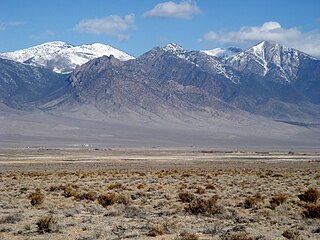
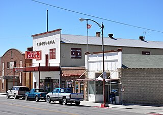
Battle Mountain is an unincorporated town in and the county seat of Lander County, Nevada, United States. The population was 3,635 at the 2010 census. Its primary economic base is gold mining and to a lesser extent, legalized gaming.

McGill, Nevada CDP in Nevada, United States

McGill is a census-designated place (CDP) in White Pine County, Nevada, United States. The population was 1,148 at the 2010 census.

Gold Country

The Gold Country is a historic region in the northern portion of the U.S. State of California, that is primarily on the western slope of the Sierra Nevada. It is famed for the mineral deposits and gold mines that attracted waves of immigrants, known as the 49ers, during the 1849 California Gold Rush.

Comstock Lode

The Comstock Lode is a lode of silver ore located under the eastern slope of Mount Davidson, a peak in the Virginia Range in Nevada. It was the first major discovery of silver ore in the United States, and named after American miner Henry Comstock.

Virginia and Truckee Railroad

The Virginia and Truckee Railroad is a privately owned historical heritage railroad, headquartered in Virginia City, Nevada in the United States. Its route is 14.1 miles (22.7 km) long. The railroad owns and uses the service mark "Queen of the Short Lines". The V&T Railroad runs up to seven trains per day, many in steam behind locomotive #29, a 2-8-0 Consolidation, or an ex-US Army GE 80-ton diesel from Virginia City from Memorial Day until the end of October each year.

Nevada Northern Railway transport company

The Nevada Northern Railway was a railroad in the U.S. state of Nevada, built primarily to reach a major copper producing area in White Pine County, Nevada. The railway, constructed in 1905-06, extended northward about 140 miles from Ely to a connections with the Western Pacific Railroad at Shafter and Southern Pacific Railroad at Cobre. In 1967 NN reported 40 million net ton-miles of revenue freight on 162 miles of line.

Indian Valley Railroad

The Indian Valley (IV) Railroad was a shortline railroad that was constructed from the Engels Copper Mine to a connection with the Western Pacific Railroad at Paxton, in Plumas County, northeastern California.

Copper mining in the United States

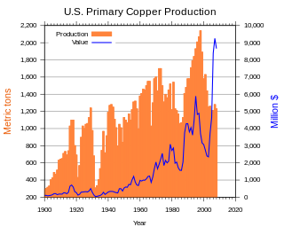
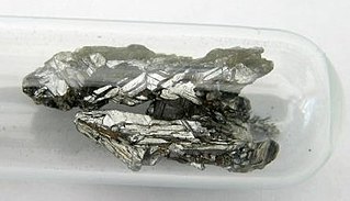
Copper mining in the United States has been a major industry since the rise of the northern Michigan copper district in the 1840s. In 2017 the United States produced 1.27 million metric tonnes of copper, worth $8 billion, making it the world's fourth largest copper producer, after Chile, China, and Peru. Copper was produced from 23 mines in the US. Top copper producing states in 2014 were Arizona, Utah, New Mexico, Nevada, and Montana. Minor production also came from Idaho, and Missouri. As of 2014, the US had 45 million tonnes of known remaining reserves of copper, the fifth largest known copper reserves in the world, after Chile, Australia, Peru, and Mexico.

Feather River Route rail line built and operated by Western Pacific Railroad; runs between Oakland, California and Salt Lake City, Utah, in the USA

The Feather River Route is a rail line that was built and operated by the Western Pacific Railroad. It was constructed between 1906 and 1909, and connects the cities of Oakland, California, and Salt Lake City, Utah. The line was built to compete with the Central Pacific Railroad, which at the time held a nearly complete monopoly on Northern California rail service. The route derives its name from its crossing of the Sierra Nevada, where it follows both the North and Middle Forks of the Feather River. The route is famous for its impressive engineering qualities and its considerable scenic value. All of the route is now owned and operated by the Union Pacific Railroad; however, the Union Pacific has transferred significant portions of the route to other lines. The portion still called the Feather River Route by the Union Pacific runs from the California Central Valley to Winnemucca, Nevada.

History of Nevada history of the US state of Nevada

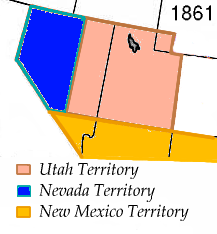
Nevada became the 36th state on October 31, 1864, after telegraphing the Constitution of Nevada to the Congress days before the November 8 presidential election. Statehood was rushed to help ensure three electoral votes for Abraham Lincoln's reelection and add to the Republican congressional majorities.

Rochester, Nevada Ghost town in Nevada, United States

Rochester, Nevada, was a silver-mining town in Pershing County, Nevada, USA, approximately 110 mi (180 km) east of Reno. It is now a ghost town. Lower Rochester is still accessible to visitors, but was largely destroyed by a wildfire in 2012; Upper Rochester has been buried under mine tailings of the more recent Coeur Rochester open pit mine.

The Sacramento Valley and Eastern Railway (SV&E) was a railway company that operated in Shasta County, California, from 1908 to the early 1930s.

Grass Creek, Utah Ghost town in Utah, United States

Grass Creek is a ghost town in Summit County, Utah, United States. Lying some 8 miles (13 km) northeast of Coalville, it was once an important coal mining town. Grass Creek was inhabited about 1860–1940.

Silver City, Utah Ghost town in Utah, United States

Silver City is a ghost town located at the mouth of Dragon Canyon on the west flank of the East Tintic Mountains in northeast Juab County in central Utah, United States. It was a silver mining town approximately 90 miles (140 km) south-southwest of Salt Lake City, Utah. This area was considered part of the Tintic Mining District and also produced bismuth, copper, gold, and lead. Settlement began with the first mining strikes here in 1869. Silver City was inhabited until 1930 after the mines ran out. Jesse Knight, known as the "Mormon Wizard" for his ability to find ore easily, decided to build a smelter in Silver City because it had the flattest ground in all of the Tintic Mining District. Silver City had several mines in 1890, but the mines hit water and were abandoned. Now there is nothing left other than a few holes where mines were, and a number of tailings piles.

Poeville, also known as Peavine until 1863, is the site of a historical mining town, established in 1864. John Poe, a professional promoter from Michigan allegedly related to Edgar Allan Poe, discovered rich gold and silver veins in 1862 on the slopes of Peavine Mountain. After the discovery of ore, Poe announced that the veins comprised the next Comstock Lode; he presented extracted ore at the state fair of 1864 as rich in content. As a result, the former mining camp, called Poe City (Poeville) or Podunk (Poedunk), grew to 200 people by 1864. Ore production in the mining district and population peaked around 1873-1874 with several hundred people living in town, supported by three hotels and a post office. The post office, named "Poeville", operated between September 1, 1874, and March 24, 1878.

Quartette or Quartette Mill or Quartette Landing, was a mining settlement, location of the stamp mill of the Quartette Mining Company, owner of the largest mine in the Searchlight Mining District and a steamboat landing on the Colorado River, in what is now Clark County, Nevada. It lay at an elevation of 646 feet.

Vancouver, Victoria and Eastern Railway

The Vancouver, Victoria and Eastern Railway was a railway line in British Columbia that was proposed in 1896 and built in stages from 1906 to 1916. It was owned by the Vancouver, Victoria, and Eastern Railway and Navigation Company, a subsidiary of the Great Northern Railway, and was managed by James J. Hill.

Nevada Copper Belt Railroad

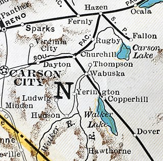
The Nevada Copper Belt Railroad was a railroad in the state of Nevada connecting Nevada-Douglas Copper Company mining facilities to the Southern Pacific's former Carson and Colorado Railway subsidiary at Wabuska, Nevada. The railroad was built south from Wabuska to the Walker River at Mason, Nevada in 1910, and began operations on 1 March. Railroad construction then proceeded up the West Walker River canyon from Mason to leave the river at Hudson reaching the Nevada-Douglas Copper Company mine at Ludwig on 1 November 1911. Rails also extended 2.54 miles (4.09 km) north from Wabuska to a smelter at Thompson. Agricultural products from irrigated ranches along the Walker River provided revenues in addition to the ore traffic.

References

International Standard Book Number Unique numeric book identifier

The International Standard Book Number (ISBN) is a numeric commercial book identifier which is intended to be unique. Publishers purchase ISBNs from an affiliate of the International ISBN Agency.