
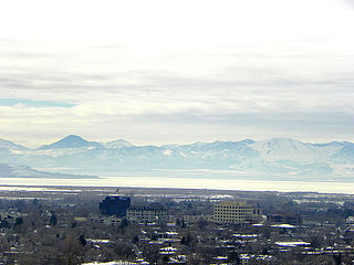
Tooele is a city in Tooele County in the U.S. state of Utah. The population was 35,742 at the 2020 census. It is the county seat of Tooele County. Located approximately 30 minutes southwest of Salt Lake City, Tooele is known for Tooele Army Depot, for its views of the nearby Oquirrh Mountains and the Great Salt Lake.
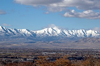
The Oquirrh Mountains is a mountain range that runs north-south for approximately 30 miles (50 km) to form the west side of Utah's Salt Lake Valley, separating it from Tooele Valley. The range runs from northwestern Utah County–central & eastern Tooele County, to the south shore of the Great Salt Lake. The highest elevation is Flat Top Mountain at 10,620 ft. The name Oquirrh was taken from the Goshute word meaning "wood sitting."

The Bingham Canyon Mine, more commonly known as Kennecott Copper Mine among locals, is an open-pit mining operation extracting a large porphyry copper deposit southwest of Salt Lake City, Utah, in the Oquirrh Mountains. The mine is the largest man-made excavation, and deepest open-pit mine in the world, which is considered to have produced more copper than any other mine in history – more than 19,000,000 short tons. The mine is owned by Rio Tinto Group, a British-Australian multinational corporation. The copper operations at Bingham Canyon Mine are managed through Kennecott Utah Copper Corporation which operates the mine, a concentrator plant, a smelter, and a refinery. The mine has been in production since 1906, and has resulted in the creation of a pit over 0.75 miles (1,210 m) deep, 2.5 miles (4 km) wide, and covering 1,900 acres. It was designated a National Historic Landmark in 1966 under the name Bingham Canyon Open Pit Copper Mine. The mine experienced a massive landslide in April 2013 and a smaller slide in September 2013.

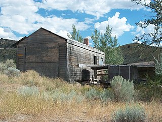
Mercur is a historical hard rock mining ghost town in Tooele County, Utah, United States. In 1891, it became the site of the first successful use of the cyanide process of gold extraction in the United States, the dominant metallurgy today. Its elevation above sea level is approximately 2,042 m. The nearby Mercur Gold Mine was re-opened by Barrick Gold in 1985, with mining operations again coming to an end in 1997. The reclamation and restoration project was set to continue up to 2010.
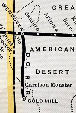
The Deep Creek Railroad is a defunct railroad company that constructed and operated a line between Wendover and Gold Hill, Utah, a distance of about 45 miles. It was constructed in 1917 to serve a mining district in the Gold Hill vicinity and existed for 22 years before succumbing to perennially weak traffic levels.
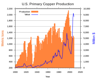
In the United States, copper mining has been a major industry since the rise of the northern Michigan copper district in the 1840s. In 2017, the US produced 1.27 million metric tonnes of copper, worth $8 billion, making it the world's fourth largest copper producer, after Chile, China, and Peru. Copper was produced from 23 mines in the US. Top copper producing states in 2014 were Arizona, Utah, New Mexico, Nevada, and Montana. Minor production also came from Idaho, and Missouri. As of 2014, the US had 45 million tonnes of known remaining reserves of copper, the fifth largest known copper reserves in the world, after Chile, Australia, Peru, and Mexico.
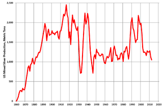
Silver mining in the United States began on a major scale with the discovery of the Comstock Lode in Nevada in 1858. The industry suffered greatly from the demonetization of silver in 1873 by the Coinage Act of 1873, known pejoratively as the "Crime of 73", but silver mining continues today.

Frisco is a ghost town in Beaver County, Utah, United States. It was an active mining camp from 1879 to 1929. At its peak in 1885, Frisco was a thriving town of 6,000 people.
Kimberly is a ghost town in the northwest corner of Piute County, Utah, United States. Located high in Mill Canyon on the side of Gold Mountain in the Tushar Mountains, Kimberly was formerly a gold mining town. Originally settled in the 1890s, it lasted until 1910. Kimberly had a minor rebirth in the 1930s, but has been uninhabited since approximately 1938. The town is perhaps best known as the birthplace of Ivy Baker Priest, a former United States Treasurer.
Mammoth is an unincorporated community and semi-ghost town in northeastern Juab County, Utah, United States.

Forest City is a ghost town in Utah County, Utah, United States. It is located in the valley of Dutchman Flat in the upper part of American Fork Canyon, in the Uinta National Forest. A silver mining town just over the mountain from Alta, Forest City was inhabited about 1871–1880. The town grew up around the smelter that was built to process ore from the canyon's mines. The American Fork Railroad, which was intended to serve Forest City and the smelter, stopped short of its destination due to engineering difficulties. Transportation costs rose too high for the mines to continue operating profitably. As the smelter, mines, and railroad closed down, Forest City was abandoned.
Grass Creek is a ghost town in Summit County, Utah, United States. Lying some 8 miles (13 km) northeast of Coalville, it was once an important coal mining town. Grass Creek was inhabited circa 1860–1940.

Silver City is a ghost town located at the mouth of Dragon Canyon on the west flank of the East Tintic Mountains in northeast Juab County in central Utah, United States. It was a silver mining town approximately 90 miles (140 km) south-southwest of Salt Lake City. This area was considered part of the Tintic Mining District and also produced bismuth, copper, gold, and lead. Settlement began with the first mining strikes here in 1869. Silver City was inhabited until 1930, after the mines played out. Jesse Knight, known as the "Mormon Wizard" for his ability to find ore easily, decided to build a smelter in Silver City because it had the flattest ground in all of the Tintic Mining District. Silver City had several mines in 1890, but the mines hit water and were abandoned. Now there is little left other than a few holes where mines were, and a number of tailings piles. The Silver City Cemetery, however, survives and is listed on the National Register of Historic Places.
Winter Quarters is a ghost town in Carbon County, Utah, United States. Coal was discovered in the area in 1875, and later that year, the Pleasant Valley Coal Company began coal mining operations. A group of coal miners were delayed during an early winter storm in 1877, which led to the town's name of Winter Quarters. On May 1, 1900, an explosion in the Winter Quarters Number Four mine killed 200 miners. Despite the mine explosion, the coal mining operations remained active until 1922, when the opening of a new mine in Castle Gate caused many people to relocate there. By 1930, Winter Quarters was abandoned.

Little Cottonwood Creek is one of the principal streams entering Salt Lake Valley from the east. The creek rises near the summit of the Wasatch Mountains, a short distance south of the ski resort town of Alta, and flows in a westerly direction through Little Cottonwood Canyon until it emerges into Salt Lake Valley about eleven miles from its source. Thence its course is north westerly through Sandy, Midvale and Murray, Utah until it empties into the Jordan River, about six miles south of Salt Lake City. Its whole length is nearly 27 miles (43 km). The headwaters of Little Cottonwood Creek are in Little Cottonwood Canyon, a glaciated canyon in Uinta-Wasatch-Cache National Forest and the Wasatch and Uinta Mountains eco-region. One of the main tributaries of the creek rises in Cecret Lake, a small sheet of water situated near Alta. The entire Little Cottonwood Creek drainage basin encompasses 46 square miles (120 km2), ranging in elevation from about 4,490 to 11,500 feet.
Roach is a ghost town and railroad siding in Clark County, Nevada, United States. It is located along the Union Pacific Railroad, between Jean, Nevada and Nipton, California.
Golden is a ghost town in Box Elder County, Utah, United States. It is located 6 miles (9.7 km) west of Park Valley, near the southern base of the Raft River Mountains.
The East Tintic Mountains are a mountain range in central Juab, Utah, and Tooele counties in Utah, United States on the east margin of the Great Basin just west of the Wasatch Front about 50 miles (80 km) south-southeast of Salt Lake City. The community of Eureka is an old mining town near the center of the range. U.S. Route 6 Passes through the central part of the range and through Eureka.

Salduro is a ghost town located in Tooele County, Utah, United States.
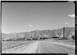
The International Smelting and Refining Company was a subsidiary of Anaconda Copper that operated primarily out of the International Smelter near Tooele, Utah. The International Smelter began operation in 1910 as a copper producer handling ores from Bingham Canyon and was expanded into a lead smelting operation in 1912. Copper smelting finished at International in 1946, and the lead smelter shut down in January 1972. The closure of the smelter would lead to the associated Tooele Valley Railway to be shut down ten years later in 1982. The company also handled several other Anaconda owned interests. After the shut down of several of the International Smelting sites, environmental reclamation has been performed by Anaconda Copper's successor company ARCO and the EPA Superfund program.


