
Utah is a landlocked state in the Mountain West subregion of the Western United States. It is bordered to its east by Colorado, to its northeast by Wyoming, to its north by Idaho, to its south by Arizona, and to its west by Nevada. Utah also touches a corner of New Mexico in the southeast. Of the fifty U.S. states, Utah is the 13th-largest by area; with a population over three million, it is the 30th-most-populous and 11th-least-densely populated. Urban development is mostly concentrated in two areas: the Wasatch Front in the north-central part of the state, which is home to roughly two-thirds of the population and includes the capital city, Salt Lake City; and Washington County in the southwest, with more than 180,000 residents. Most of the western half of Utah lies in the Great Basin.

Juab County is a county in western Utah, United States. As of the 2020 United States Census, the population was 11,786. Its county seat and largest city is Nephi.

Salt Lake County is located in the U.S. state of Utah. As of the 2020 United States census, the population was 1,185,238, making it the most populous county in Utah. Its county seat and largest city is Salt Lake City, the state capital. The county was created in 1850. Salt Lake County is the 37th most populated county in the United States and is one of four counties in the Rocky Mountains to make it into the top 100. Salt Lake County is the only county of the first class in Utah – under the Utah Code is a county with a population of 700,000 or greater.

Tooele County is a county in the U.S. state of Utah. As of the 2020 United States Census, the population was 72,698. Its county seat and largest city is Tooele. The county was created in 1850 and organized the following year.

Howell is a town located in the Blue Creek Valley in northeast Box Elder County, Utah, United States. The population was 245 at the 2010 census.
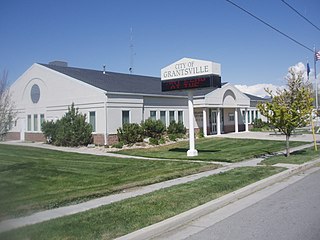
Grantsville is the second most populous city in Tooele County, Utah, United States. It is part of the Salt Lake City, Utah Metropolitan Statistical Area. The population was 12,617 at the 2020 census. The city has grown slowly and steadily throughout most of its existence, but rapid increases in growth occurred during the 1970s, 1990s, and 2010s. Recent rapid growth has been attributed to being close to Salt Lake City, small town community feel, lower housing costs than Salt Lake County, the nearby Deseret Peak recreational center, the Utah Motorsports Campus raceway, and the newly built Wal-Mart distribution center located just outside the city. It is quickly becoming a bedroom community for commuters into the Salt Lake Valley.

Stansbury Park is a census-designated place (CDP) in Tooele County, Utah, United States. As of the 2020 United States Census, the population was 9,851, up from the 2010 figure of 5,145.

Tooele is a city in Tooele County in the U.S. state of Utah. The population was 35,742 at the 2020 census. It is the county seat of Tooele County. Located approximately 30 minutes southwest of Salt Lake City, Tooele is known for Tooele Army Depot, for its views of the nearby Oquirrh Mountains and the Great Salt Lake.

Vernon is a town in southeastern Tooele County, Utah, United States.
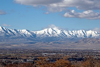
The Oquirrh Mountains is a mountain range that runs north-south for approximately 30 miles (50 km) to form the west side of Utah's Salt Lake Valley, separating it from Tooele Valley. The range runs from northwestern Utah County–central & eastern Tooele County, to the south shore of the Great Salt Lake. The highest elevation is Flat Top Mountain at 10,620 ft. The name Oquirrh was taken from the Goshute word meaning "wood sitting."
Black Rock is an unincorporated community and near-ghost town in the Beaver Bottoms in southern Millard County, Utah, United States, approximately 20 miles (32 km) north of Milford.
Faust is a settlement located in central Tooele County, Utah, United States.

Interstate 80 (I-80) is a part of the Interstate Highway System that runs from San Francisco, California, to Teaneck, New Jersey. The portion of the highway in the US state of Utah is 197.51 miles (317.86 km) long through the northern part of the state. From west to east, I-80 crosses the state line from Nevada in Tooele County and traverses the Bonneville Salt Flats—which are a part of the larger Great Salt Lake Desert. It continues alongside the Wendover Cut-off—the corridor of the former Victory Highway—US Route 40 (US-40) and the Western Pacific Railroad Feather River Route. After passing the Oquirrh Mountains, I-80 enters the Salt Lake Valley and Salt Lake County. A short portion of the freeway is concurrent with I-15 through Downtown Salt Lake City. At the Spaghetti Bowl, I-80 turns east again into the mouth of Parleys Canyon and Summit County, travels through the mountain range, and intersects the eastern end of I-84 near Echo Reservoir before turning northeast toward the Wyoming border near Evanston. I-80 was built along the corridor of the Lincoln Highway and the Mormon Trail through the Wasatch Range. The easternmost section also follows the historical routes of the first transcontinental railroad and US-30S.

The Wendover Cut-off, also called the Wendover Road or Wendover Route, is a two-lane highway in the western part of Tooele County in the U.S. state of Utah. Stretching 40.3 miles (64.9 km) from Wendover to Knolls across the Bonneville Salt Flats, a part of the Great Salt Lake Desert, the cut-off was once part of the primary link between the Nevada state line and Salt Lake City. In 2012, between 240 and 250 vehicles used the cut-off near its western terminus in Wendover on an average day.

Lake Point is a city on the eastern edge of northern Tooele County, Utah, United States. It is located 17 miles southwest of Salt Lake City International Airport and 11 miles north of Tooele, Utah. At its location on the south shore of the Great Salt Lake, the city is served by Interstate 80 and Utah State Route 36.
Trout Creek is an unincorporated community, in far western Juab County, Utah, United States.

The Stansbury Mountains are a 28-mile (45 km) long mountain range located in eastern Tooele County, Utah. It is named for U.S. Army Major Howard Stansbury, a topographical engineer, who led an expedition that surveyed the region.
Knolls is an unincorporated community in north-central Tooele County, Utah, United States.

Salduro is a ghost town located in Tooele County, Utah, United States.

Jenkins Peak is a 7,268-foot elevation (2,215 m) mountain summit located in Tooele County, Utah, United States.


