
Juab County is a county in western Utah, United States. As of the 2020 United States Census, the population was 11,786. Its county seat and largest city is Nephi.

Salt Lake County is located in the U.S. state of Utah. As of the 2020 United States census, the population was 1,185,238, making it the most populous county in Utah. Its county seat and largest city is Salt Lake City, the state capital. The county was created in 1850. Salt Lake County is the 37th most populated county in the United States and is one of four counties in the Rocky Mountains to make it into the top 100. Salt Lake County is the only county of the first class in Utah – under the Utah Code is a county with a population of 700,000 or greater.

Tooele County is a county in the U.S. state of Utah. As of the 2020 United States Census, the population was 72,698. Its county seat and largest city is Tooele. The county was created in 1850 and organized the following year.

Magna is a metro township in Salt Lake County, Utah, United States. The current population of the township stands at 29,251 according to the 2020 census, a 10.4% increase over 26,505 in 2010.

Stansbury Park is a census-designated place (CDP) in Tooele County, Utah, United States. As of the 2020 United States Census, the population was 9,851, up from the 2010 figure of 5,145.

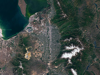
Tooele is a city in Tooele County in the U.S. state of Utah. The population was 35,742 at the 2020 census. It is the county seat of Tooele County. Located approximately 30 minutes southwest of Salt Lake City, Tooele is known for Tooele Army Depot, for its views of the nearby Oquirrh Mountains and the Great Salt Lake.

The Wasatch Front is a metropolitan region in the north-central part of the U.S. state of Utah. It consists of a chain of mostly contiguous cities and towns stretched along the Wasatch Range from approximately Santaquin in the south to Logan in the north, and containing the cities of Salt Lake City, Bountiful, Layton, and Ogden.

The Utah Transit Authority (UTA) is a special service district responsible for providing public transportation throughout the Wasatch Front of Utah, in the United States, which includes the metropolitan areas of Ogden, Park City, Provo, Salt Lake City and Tooele. It operates fixed route buses, flex route buses, express buses, ski buses, three light rail lines in Salt Lake County (TRAX), a streetcar line in Salt Lake City, and a commuter rail train (FrontRunner) from Ogden through Salt Lake City to Provo. UTA is headquartered in Salt Lake City with operations and garages in locations throughout the Wasatch Front, including Ogden, Midvale and Orem. Light rail vehicles are stored and maintained at yards at locations in South Salt Lake and Midvale. UTA's commuter rail equipment is stored and serviced at a facility in Salt Lake City. In 2022, the system had a ridership of 31,233,700, or about 113,500 per weekday as of the first quarter of 2023.
Salt Lake Valley is a 500-square-mile (1,300 km2) valley in Salt Lake County in the north-central portion of the U.S. state of Utah. It contains Salt Lake City and many of its suburbs, notably Murray, Sandy, South Jordan, West Jordan, and West Valley City; its total population is 1,029,655 as of 2010. Brigham Young said, "this is the right place," when he and his fellow Mormon settlers moved into Utah after being driven out of several states.
Transportation in Salt Lake City consists of a wide network of roads, an extensive bus system, a light rail system, and a commuter rail line. Although Salt Lake City, Utah, is a traditionally car-oriented city, the rapidly growing public transit system has a high number of riders for a city of its size, and public transit is widely supported by its residents and businesses.

William Adams "Wild Bill" Hickman was an American frontiersman. He also served as a representative to the Utah Territorial Legislature.

Interstate 80 (I-80) is a part of the Interstate Highway System that runs from San Francisco, California, to Teaneck, New Jersey. The portion of the highway in the US state of Utah is 197.51 miles (317.86 km) long through the northern part of the state. From west to east, I-80 crosses the state line from Nevada in Tooele County and traverses the Bonneville Salt Flats—which are a part of the larger Great Salt Lake Desert. It continues alongside the Wendover Cut-off—the corridor of the former Victory Highway—US Route 40 (US-40) and the Western Pacific Railroad Feather River Route. After passing the Oquirrh Mountains, I-80 enters the Salt Lake Valley and Salt Lake County. A short portion of the freeway is concurrent with I-15 through Downtown Salt Lake City. At the Spaghetti Bowl, I-80 turns east again into the mouth of Parleys Canyon and Summit County, travels through the mountain range, and intersects the eastern end of I-84 near Echo Reservoir before turning northeast toward the Wyoming border near Evanston. I-80 was built along the corridor of the Lincoln Highway and the Mormon Trail through the Wasatch Range. The easternmost section also follows the historical routes of the first transcontinental railroad and US-30S.

The Wendover Cut-off, also called the Wendover Road or Wendover Route, is a two-lane highway in the western part of Tooele County in the U.S. state of Utah. Stretching 40.3 miles (64.9 km) from Wendover to Knolls across the Bonneville Salt Flats, a part of the Great Salt Lake Desert, the cut-off was once part of the primary link between the Nevada state line and Salt Lake City. In 2012, between 240 and 250 vehicles used the cut-off near its western terminus in Wendover on an average day.
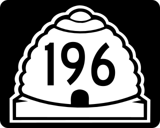
State Route 196 is a north-south state highway located entirely in Tooele County, Utah that begins at SR-199 and ends at I-80. It passes through Skull Valley, and was added to the state highway system in 1998 to prevent the Skull Valley Band of Goshute Indians from using their reservation to store nuclear waste.

Lake Point is a city on the eastern edge of northern Tooele County, Utah, United States. It is located 17 miles southwest of Salt Lake City International Airport and 11 miles north of Tooele, Utah. At its location on the south shore of the Great Salt Lake, the city is served by Interstate 80 and Utah State Route 36.

The Stansbury Mountains are a 28-mile (45 km) long mountain range located in eastern Tooele County, Utah. It is named for U.S. Army Major Howard Stansbury, a topographical engineer, who led an expedition that surveyed the region.

The Tooele Valley Railway was a railroad founded in 1908, and owned by the Anaconda Copper corporation. The line ran from a connection with the Union Pacific Railroad and the Western Pacific Railroad at Warner Station on the western edge of Tooele, Utah, to a terminus at the International Smelting and Refining Company smelter operations on the eastern edge of Tooele. The line was abandoned around 1982, nearly a decade after the smelter closure and the end of production at the nearby Carr Fork Mine.
Knolls is an unincorporated community in north-central Tooele County, Utah, United States.

The Aragonite Hazardous Waste Incinerator is a waste disposal facility currently operated by Clean Harbors. It is located in Aragonite, Tooele County, Utah, United States, located in the western portion of the state.

Salduro is a ghost town located in Tooele County, Utah, United States.


