Lake Point, Utah

Last updated
Lake Point
City
City of Lake Point
Lake Point.jpg
Lake Point Logo.svg
Lake Point, Utah
Interactive map of Lake Point
USA Utah relief location map.svg
Red pog.svg
Lake Point
Location within Utah
Usa edcp relief location map.png
Red pog.svg
Lake Point
Location within the United States
Coordinates: 40°40′51″N112°15′47″W / 40.68083°N 112.26306°W / 40.68083; -112.26306 Coordinates: 40°40′51″N112°15′47″W / 40.68083°N 112.26306°W / 40.68083; -112.26306
CountryFlag of the United States.svg  United States
State Flag of Utah.svg  Utah
County Tooele County
Settled1854
Incorporated 2022
Government
  TypeFive-Member Council
Area
  Total4.6 sq mi (12 km2)
Elevation
4,246 ft (1,294 m)
Population
 (2020)
  Total2,599
Time zone UTC-7 (Mountain (MST))
  Summer (DST) UTC-6 (MDT)
Zip Code
84074
Area code 435
GNIS feature ID 1429437 [1] [2]
U.S. Highways I-80 (UT).svg
State Routes Utah 36.svg
Website https://lakepoint.gov/

Lake Point is a city on the eastern edge of northern Tooele County, Utah, United States. [3] It is located 17 miles southwest of Salt Lake City International Airport and 11 miles north of Tooele, Utah. At its location on the south shore of the Great Salt Lake, the city is served by Interstate 80 and Utah State Route 36.

Contents

The community was originally settled in 1854 under the name of E.T. City, in honor of Ezra T. Benson. It was renamed Lake Point in 1923. [4]

A 2021 feasibility study for the proposed Lake Point incorporation area indicated an estimated population of 2,599. [5] During the 2021 United States elections, the residents of Lake Point voted to become a city with a five-member council; the first city council was then elected the following year. [6] [7]

History

Military Cartographers and Early Pioneers

John C. Frémont, a second lieutenant in the U.S. Army Corps of Topographical Engineers, was commissioned by the US Government to explore the Mexican territory west of the Louisiana Purchase with a special interest in the terrain and various routes that could link the Midwest to California. In the summer of 1843 Fremont took a smaller team from his men and veered off the Oregon Trail at Fort Hall to the Bear River into its terminus at the Great Salt Lake. He explored the lake on an eighteen-foot inflatable rubber boat loaded with provisions and produced a map of the lake and its surroundings. [8]

From 1843-1846 Fremont made several expeditions which included a route south of the Great Salt Lake and eastward to the Humboldt River in Nevada. On January 1846, Fremont met with Lansford Hastings, another explorer military man who shared a passion for driving settlement in California. A year earlier, in 1845, Hastings published a popular book called "The Emigrants' Guide to Oregon and California" which contained a passage that said the quickest route to the San Francisco Bay was a diversion from Fort Hall on the Oregon Trail "...bearing West Southwest, to the Salt Lake". [9] Fremont's detailed explanations of his most recent expedition south of the Great Salt Lake was received with much enthusiasm by Hastings. In 1846 Fremont would continue to publish details of his explorations through Utah and Nevada and Hastings set out with teams of men in recruiting settlers to use the Hastings Cutoff. [10] Many of the settlers who tried the new route found it very challenging but did make it to their destinations.

The Donner Party were numbered among these same initial pioneers on the Hastings Cutoff, but were slowed down for a variety of reasons including road building activities. Journal entries and interviews describe the Donner Party meeting the "Hastings Trail" on the south side of the Great Salt Lake in August 1846. In later interviews Donner Party member, Reed, was quoted multiple times saying that they had met Lansford Hastings near the landmark (on the eastern border of Lake Point) known as Black Rock and that they were the ones who had given the rock its name. [11] In late August, the Donner Party crossed a field from the Great Salt Lake to a spring at the point of the lake mountain. The location of this camp is present day Emigration Park in Lake Point with a Donner Party Trail historical marker. The remainder of the Donner Party's passage through the Hastings Cuttoff would become infamous in highlighting the route's lack of water, its grueling heat, and unforgiving winter. Their later depravations and loss became a warning to all travelers.

Brigham Young had studied the published maps and articles written by John Fremont which greatly influenced his route and destination for a new Mormon settlement. [12] The Brigham Young led the first Mormon pioneers into the Salt Lake Valley almost a year after the Donner Party first arrived. On July 27, 1847, just 3 days later, Brigham Young and 16 other men set out to examine the Hasting Cutoff trail along the south side of the lake and to evaluate the water, soil, timber, and other natural resources of Tooele Valley. No bold plans for the valley materialized in that expedition but it was concluded that there was potential for pastorage. [13]

Similar to John Fremont, the U.S. Army Corps of Topographical Engineers ordered Captain Howard Stansbury to take his team to the Salt Lake Valley to gain better understanding of the land around the Great Salt Lake for purposes of supply and travel routes, and to document resources, indigenous peoples, and Mormon settlements. [14] In November of 1849, Stansbury and his team had made a trip around the Great Salt Lake and came into the Tooele Valley. Their team had cattle and constructed an adobe structure for those watching the herd. The structure made an impression because it was one of the first known buildings in the valley. The location made an impression as well because it was adjacent to a large rock tower that had already served as a landmark for travelers. The rock tower became known as Adobe Rock. [15]

E.T. City

Pioneers of the Church of Jesus Christ of Latter-day Saints arrived in Lake Point on July 27, 1847. The team of men included Brigham Young and Orson Pratt. Pratt wrote in his journal that "We continued on about 4 miles further [beyond Black Rock], when we reached a valley putting up to the southward from the lake." Very little happened for two years from that initial visitation, Mormon settlers did travel the area and perhaps dwelled in an official capacity, but the Tooele Valley wasn't formally organized as a colony for members of the Church until Apostle Ezra T. Benson hired men to build mills and watch his cattle in the valley. Cyrus and Juda Tolman along with Phineas R. Wright were brought in to build saw mills and a grist mill. And John Rowberry and Robert Skelton followed shortly after on December of 1849 to winter Benson's cattle. When the 1850 census was taken a year and a half later, all 5 men and their families were accounted for as living in Settlement Canyon in what is now Tooele City. [16]

On April 24, 1850 Ezra T. Benson visited the new settlement and organized the first LDS branch with Rowberry as Bishop. By late Spring and Summer of that year more Mormon settlers came into the valley including Peter Maughan and his family. [17] Tooele County was organized on April, 1851 with Peter Maughan appointed to the position of County Clerk. In 1852 Settlement Canyon Fort, which included Peter Maughan's home, was dissembled and moved closer to present day city center in Tooele. On November of 1853, Maughan, Rowberry, and Bates were appointed a committee to both "...locate E.T. City and for building a dam at Rock Springs [Adobe Springs Creek]." In 1854 $700 was expended to build the dam, which failed because the water seeped through an underground passage so that water would not rise. The committee then had to spend an additional $300 to bring water from Twin Springs to the location of the new settlement; Twin Springs was the same source of water for the Benson Grist Mill which was completed that same year. In August of 1854 the Maughan house was dissembled and moved for a second time, now to the location that was selected for E.T. City. There were others who joined him who built small houses along the north-south road. On October 1854, Maughan was appointed as the Presiding Elder over E.T. City. [18] [19] According to the Utah Centennial County History Series, E.T. City was a precinct named after Ezra Taft Benson that extended from the Benson Grist Mill to E.T. Hill (Adobe Rock), and all the way over to Black Rock (Great Salt Lake). This was formalized in 1855 by Ezra Taft Benson who represented Tooele County in the Utah Territorial Legislature. [20]

Benson Grist mill4.jpg
Benson Grist Mill
Adobe Rock.jpg
Adobe Rock

The first year of farming in E.T. City in 1855, the crops showed great promise of reaching maturity until they were destroyed by a massive swarm of grasshoppers. In 1856 the watering of their crops brought out saleratus in the soil that destroyed most of that year's harvest. Upon hearing the plight of the people in the new settlement, Brigham Young permitted a committee of 6 men led by Maughan to explore Cache Valley for a new location. They departed on July 21, 1856 and returned home safely. In late August, Brigham Young allowed for any man and his family to leave E.T. City to go with Peter Maughan to settle in Cache Valley. Some were glad to do so. They arrived at their new location in September of that same year and built Maughan's Fort which became Wellsville, Utah. In 1860, Ezra T. Benson joined Maughan to direct religious affairs and assist in settling the Cache Valley area. [21] [22]

Historical population
CensusPop.Note
1860 141
1870 114−19.1%
1880 17755.3%
1890 20616.4%
1900 192−6.8%
1910 179−6.8%
1920 1969.5%
1930 29952.6%
1940 231−22.7%
1950 190−17.7%
Source: U.S. Census Bureau [23]

The first meetinghouse of the LDS branch was built in 1857, a small log building with a rough board floor, dirt roof, and two windows.

The branch's population was listed as 97 in 1868 ("and some gentile families"); by then the E.T. Irrigation Company had been formed, a canal delivered irrigation water from the Mill Pond, a regular mail run existed between E.T. City and Richville.

An LDS Church meetinghouse built of rock was completed in 1884. It was also used as an elementary school until 1894, when a separate schoolhouse was constructed.

The rock LDS chapel was replaced in November 1985 by a modern brick-faced building a half-mile south of the previous building.

Tourism and The Utah Western Railway

Heber C. Kimball Black Rock Ranch House Heber C. Kimball Black Rock Ranch House.png
Heber C. Kimball Black Rock Ranch House
Clinton's Lake House Hotel at Lake Point Resort on the Great Salt Lake. The City of Corinne Steamboat and Utah Western Railway is Represented as well. Lake Point Resort.png
Clinton's Lake House Hotel at Lake Point Resort on the Great Salt Lake. The City of Corinne Steamboat and Utah Western Railway is Represented as well.
The City of Corinne Steamboat docked at the Lake Point Resort Pier. CityofCorinneSteamboat.jpg
The City of Corinne Steamboat docked at the Lake Point Resort Pier.

Bathing in the Great Salt Lake was a popular recreational activity from the first arrival of the Mormon Pioneers. In 1860, LDS Apostle Heber C. Kimball built a rock ranch house next to the Black Rock landmark which had become a very popular location for bathing in the lake. The home had bath houses used for leisure and entraining guests. It became the first of many built tourist attractions along the Great Salt Lake. Heber C. Kimball died 8 years later in 1868, but his son Heber P. Kimball, John Willard Young (the third son of Brigham Young), and Dr. Jeter Clinton would bring an unprecedented level of resort and transportation investment to the Lake Point area.

In 1869, Brigham Young tasked John W. Young with the formation and construction of the Utah Central Railroad which would connect Salt Lake City to the first transcontinental railroad in Ogden. The line was completed in January 1870. One of the stops on the line was a station called Lake Side. Adjacent to this station was the Lake Side resort which opened June of that same year.

Less than a year later, in the spring of 1871, Jeter Clinton's Lake House was built at a location called Clinton's Landing in Lake Point. From Young's Lake Side resort one could pay 25-cents "to ride on the City of Corinne, a steamboat, going to Lake Point on the south shore". [24] Within 4 years, and two railroad companies later, John W. Young became president of the newly formed Utah Western Railway and Heber P. Kimball treasurer and superintendent of construction. [25] On February 7, 1875 they connected Salt Lake City to a train stop called Lake Point, adjacent to this station was Clinton’s new three story Lake Point Hotel with bath houses and a dock prepared to receive the City of Corinne Steamboat. In 1877 John Muir wrote, "Lake Point is only an hour or two from the city, and has hotel accommodations and a steamboat for excursions; and then, besides the bracing waters, the climate is delightful...The crystal brightness of the water, the wild flowers, and the lovely mountain scenery make this a favorite summer resort for pleasure and health seekers. Numerous excursion trains are run from the city, and parties, some of them numbering upwards of a thousand, come to bathe, and dance, and roam the flowery hillsides together". [26]

The success of the Lake Point brand surrounding both the railroad stop and the resort pulled the community's identity into its gravity. The town was named E.T. City in the census on one occasion in the decade that it was first settled, but that name lost out to Lake Point in identifying the town to a majority of outsiders looking to interact with the settlement in terms of labels on maps, post office naming, rail stops, and later highway signage. At a parochial level, the townspeople in the settlement would continue to identify their community as the E.T. Ward.

Early railroading was very difficult with many smaller railroads ultimately folding and becoming part of larger railroad companies. On September 16, 1877 the Utah Western Railway completed its initial buildout to receive freight from Stockton, Utah, but the company was losing money. [27] It ultimately sold under foreclosure on November 3, 1880 and rebranded into the Utah & Nevada Railway with further consolidation and renaming in its future. Operating a successful resort on the Great Salt Lake was perhaps just as difficult of an endeavor. The Lake Point Resort had to contend with demand for its product becoming too large for its scale. And thus competition with a newer and larger resorts further up the eastern shore. The second challenge it had to face was drastically varying lake levels that left the facilities far away from the water's edge.

In 1892 the Clinton property was sold to the Buffalo Park Land Company, who envisioned a large resort on the area. They mapped streets, planted trees, imported buffalo, and began building cabins. However, the venture did not succeed, and the remaining buffalo became the nucleus of the buffalo herd on nearby Antelope Island.

Geography

The Lake Point Oquirrh Mountains Lake Point 1941.jpg
The Lake Point Oquirrh Mountains

Looking southward from the south end of Salt Lake, the two northmost peaks of the Oquirrh Range are seen swelling calmly into the cool sky without any marked character, excepting only their snow crowns, and a few weedy-looking patches of spruce and fir, the simplicity of their slopes preventing their real loftiness from being appreciated. Gray, sagey plains circle around their bases, and up to a height of a thousand feet or more their sides are tinged with purple, which I afterwards found is produced by a close growth of dwarf oak just coming into leaf. Higher you may detect faint tintings of green on a gray ground, from young grasses and sedges; then come the dark pine woods filling glacial hollows, and over all the smooth crown of snow.

John Muir [28]

Climate

See also

Flag of Utah.svg  Utahportal

Related Research Articles

<span class="mw-page-title-main">Great Salt Lake</span> Salt lake in Utah, United States

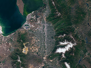
The Great Salt Lake is the largest saltwater lake in the Western Hemisphere and the eighth-largest terminal lake in the world. It lies in the northern part of the U.S. state of Utah and has a substantial impact upon the local climate, particularly through lake-effect snow. It is a remnant of Lake Bonneville, a prehistoric body of water that covered much of western Utah.

<span class="mw-page-title-main">Tooele County, Utah</span> County in Utah, United States

Tooele County is a county in the U.S. state of Utah. As of the 2010 United States Census, the population was 58,218. Its county seat and largest city is Tooele. The county was created in 1850 and organized the following year.

<span class="mw-page-title-main">Stansbury Park, Utah</span> CDP and Township in Utah, United States

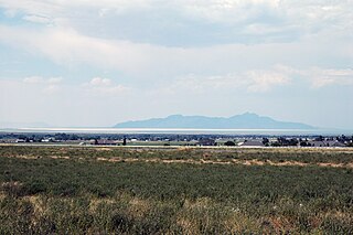
Stansbury Park is a census-designated place (CDP) in Tooele County, Utah, United States. As of the 2020 United States Census, the population was 9,851, up from the 2010 figure of 5,145.

<span class="mw-page-title-main">Ezra Taft Benson</span> President of The Church of Jesus Christ of Latter-day Saints (1899–1994)

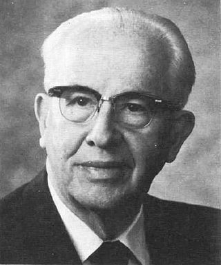
Ezra Taft Benson was an American farmer, government official, and religious leader who served as the 15th United States Secretary of Agriculture during both presidential terms of Dwight D. Eisenhower and as the 13th president of the Church of Jesus Christ of Latter-day Saints from 1985 until his death in 1994.

<span class="mw-page-title-main">Mormon Trail</span> Migrant route from Illinois, to Salt Lake City, Utah, USA

The Mormon Trail is the 1,300-mile (2,100 km) long route from Illinois to Utah that members of the Church of Jesus Christ of Latter-day Saints traveled from 1846-47. Today, the Mormon Trail is a part of the United States National Trails System, known as the Mormon Pioneer National Historic Trail.

<span class="mw-page-title-main">Mormon pioneers</span> Members of the Latter-day Saints church who moved to the western U.S. in the 1840s

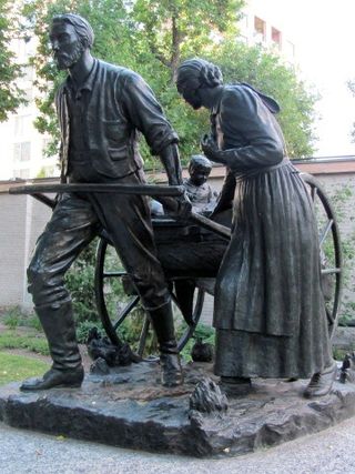
The Mormon pioneers were members of the Church of Jesus Christ of Latter-day Saints, also known as Latter Day Saints, who migrated beginning in the mid-1840s until the late-1860s across the United States from the Midwest to the Salt Lake Valley in what is today the U.S. state of Utah. At the time of the planning of the exodus in 1846, the territory was part of the Republic of Mexico, with which the U.S. soon went to war over a border dispute left unresolved after the annexation of Texas. The Salt Lake Valley became American territory as a result of this war.

<span class="mw-page-title-main">Ezra T. Benson</span> American religious leader

Ezra Taft Benson was an apostle and a member of the Quorum of the Twelve Apostles of the Church of Jesus Christ of Latter-day Saints.

<span class="mw-page-title-main">Salt Lake Valley</span> Geographic depression in northern Utah, US, containing Salt Lake City and its suburbs

Salt Lake Valley is a 500-square-mile (1,300 km2) valley in Salt Lake County in the north-central portion of the U.S. state of Utah. It contains Salt Lake City and many of its suburbs, notably Murray, Sandy, South Jordan, West Jordan, and West Valley City; its total population is 1,029,655 as of 2010. Brigham Young said, "this is the right place," when he and his fellow Mormon settlers moved into Utah after being driven out of several states.

<span class="mw-page-title-main">Hastings Cutoff</span> Historic site in Humboldt River Basin, Elko County

The Hastings Cutoff was an alternative route for westward emigrants to travel to California, as proposed by Lansford Hastings in The Emigrant's Guide to Oregon and California. The ill-fated Donner Party infamously took the route in 1846.

<span class="mw-page-title-main">History of Utah</span> History of an American state

The History of Utah is an examination of the human history and social activity within the state of Utah located in the western United States.

<span class="mw-page-title-main">This Is the Place Monument</span> Monument in Salt Lake City, Utah USA

The This is the Place Monument is a historical monument at the This is the Place Heritage Park, located on the east side of Salt Lake City, Utah, at the mouth of Emigration Canyon. It is named in honor of Brigham Young's famous statement in 1847 that the Latter-day Saint pioneers should settle in the Salt Lake Valley. Mahonri M. Young, a grandson of Brigham Young, sculpted the monument between 1939 and 1947 at Weir Farm in Connecticut. Young was awarded $50,000 to build the monument in 1939 and he was assisted by Spero Anargyros. It stands as a monument to the Mormon pioneers as well as the explorers and settlers of the American West. It was dedicated by LDS Church President George Albert Smith on 24 July 1947, the hundredth anniversary of the pioneers entering the Salt Lake Valley. It replaced a much smaller monument located nearby.

<span class="mw-page-title-main">Peter Maughan</span> American politician

Peter Maughan was an early pioneer of the Church of Jesus Christ of Latter-Day Saints who settled the Cache Valley of Utah under the direction of Brigham Young.

<span class="mw-page-title-main">Stansbury Island</span> Island in the Great Salt Lake, Utah, United States

Stansbury Island is the second largest island within the Great Salt Lake in the U.S. state of Utah. Located in Tooele County, it is considered an island even though a dirt causeway connects it to the mainland. Stansbury Island was named after Howard Stansbury, the leader of a government expedition that surveyed the lake in 1849.

The Overland Trail was a stagecoach and wagon trail in the American West during the 19th century. While portions of the route had been used by explorers and trappers since the 1820s, the Overland Trail was most heavily used in the 1860s as a route alternative to the Oregon, California, and Mormon trails through central Wyoming. The Overland Trail was famously used by the Overland Stage Company owned by Ben Holladay to run mail and passengers to Salt Lake City, Utah, via stagecoaches in the early 1860s. Starting from Atchison, Kansas, the trail descended into Colorado before looping back up to southern Wyoming and rejoining the Oregon Trail at Fort Bridger. The stage line operated until 1869 when the completion of the First transcontinental railroad eliminated the need for mail service via stagecoach.

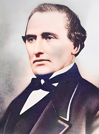
Howard Stansbury was a major in the U.S. Army Corps of Topographical Engineers. His most notable achievement was leading a two-year expedition (1849–1851) to survey the Great Salt Lake and its surroundings. The expedition report entitled Exploration and survey of the valley of the Great Salt Lake of Utah, including a reconnaissance of a new route through the Rocky Mountains was published in 1852 providing the first serious scientific exploration of the flora and fauna of the Great Salt Lake Valley as well as a favorable impression of the members of the Church of Jesus Christ of Latter-day Saints, who had settled there beginning in 1847.

<span class="mw-page-title-main">Benson Grist Mill</span> Restoration and replica museum in Stansbury Park, Utah

Benson Grist Mill is a restoration-replica museum located in Tooele County, Utah in the western United States, which allows visitors to see the inner workings of a latter-nineteenth-century pioneer gristmill. It has four other historic (nineteenth-century) buildings which have been moved onto the site, as well as four ancillary structures, including an open-air pavilion. It covers 6.98 acres along State Highway 138, 0.8 mile southwest of the intersection of the Road with State Highway 36. The museum is owned and operated by a division of Tooele County.

<span class="mw-page-title-main">Mormon settlement techniques of the Salt Lake Valley</span> Western U.S. Mormon expansion

Settlement of the Church of Jesus Christ of Latter-day Saints, also called Mormons, Latter-day Saints, or Saints in the Salt Lake Valley and surrounding area or “the planning and founding of more than 500 communities in the American West, is regarded by many planning historians as one of the most significant accomplishments in the history of American city development”. The Saints moved from settlement to settlement, until they made a permanent home in the Great Basin of the Rocky Mountains. This group of people is characterized by their ability to work together in settlement efforts. In 1847, these people trekked en masse across the great plains of the United States until they reached what is now northern Utah. Led by Brigham Young, these people used their experience of settling to establish themselves there. The church provided critical leadership by organizing and directing the efforts of the people. While Salt Lake City, the headquarters of the LDS Church, is their most prominent achievement, many other settlements in the area were also very successful. The techniques of the farm village, plats, and the grid, were all important components for the initial establishment, and later development, of the uninhabited area. The presence of the Saints in the valley was useful in the concluding efforts of the Transcontinental Railroad, where Promontory, Utah served as the connecting point of the Union Pacific and Central Pacific lines. Often labeled “the Crossroads of the West,” this area became an important hub for people traveling west, particularly for the California Gold Rush. While initially an agrarian community, the Saints became a strong force for industry as mines, factories, and rail began to be completely utilized.

Mormon Road, also known to the 49ers as the Southern Route, of the California Trail in the Western United States, was a seasonal wagon road pioneered by a Mormon party from Salt Lake City, Utah led by Jefferson Hunt, that followed the route of Spanish explorers and the Old Spanish Trail across southwestern Utah, northwestern Arizona, southern Nevada and the Mojave Desert of California to Los Angeles in 1847. From 1855, it became a military and commercial wagon route between California and Utah, called the Los Angeles – Salt Lake Road. In later decades this route was variously called the "Old Mormon Road", the "Old Southern Road", or the "Immigrant Road" in California. In Utah, Arizona and Nevada it was known as the "California Road".

The Battle at Fort Utah was a battle between the Timpanogos Tribe and remnants of the Nauvoo Legion at Fort Utah in modern-day Provo, Utah. The Timpanogos people initially tolerated the presence of the settlers, and the two groups enjoyed some moments of mutual friendship. However, after three Mormons murdered a Timpanogos man called Old Bishop for stealing, the Timpanogos then took around 50 Mormon cattle, settlers in Fort Utah petitioned to go to war with the Timpanogos. Isaac Higbee, Parley P. Pratt and Willard Richards convinced Brigham Young to exterminate any Timpanogos hostile to the Mormon settlement. Young sent the Nauvoo Legion down with Captain George D. Grant and later sent General Daniel H. Wells to lead the army. After the Timpanogos defended themselves from their village and an abandoned cabin, they fled their camp. The Mormons pursued the Timpanogos from Chief Old Elk's tribe and any other Timpanogos they found in the valley, killing Timpanogos from Chief Pareyarts or Para-yah 's tribe. The Nauvoo Legion killed some Timpanogos.

<span class="mw-page-title-main">Adobe Rock</span> A hill, more specifically, a large rock face pediment located south of Lake Point, Utah

Adobe Rock is described by the USGS as a pediment (geology) at Lake Point, Utah. The large rock outcropping sits adjacent to SR-36 just north of SR-138 at Mills Junction. Because of its distance from the steep incline of the Oquirrh Mountains and its prominent location on the edge of a hill, Adobe Rock has served as a natural landmark in Tooele Valley ever since the first pioneers traversed the Hastings Cutoff trail. Though not officially a national monument like its nearby peer Black Rock, it has equal significance as a navigating landmark and cultural significance as a monument with businesses using the Adobe Rock name, books using its images on their covers, and Lake Point, Utah depicting its likeness as their city logo.

References

  1. "Lake Point". Geographic Names Information System . United States Geological Survey, United States Department of the Interior.
  2. "US Board on Geographic Names". United States Geological Survey. 2007-10-25. Retrieved 2008-01-31.
  3. "Lake Point". Geographic Names Information System . United States Geological Survey, United States Department of the Interior.
  4. Van Cott, John W. (1990). Utah Place Names: A Comprehensive Guide to the Origins of Geographic Names: A Compilation. Salt Lake City: University of Utah Press. p. 121. ISBN   978-0-87480-345-7. OCLC   797284427.
  5. https://municert.utah.gov/Media/Default/Lake%20Point/LAKE%20POINT%20INCORPORATION%20FEASIBILITY%20STUDY%20FINAL%20030221.pdf
  6. https://le.utah.gov/xcode/Title10/Chapter3B/C10-3b-P4_1800010118000101.pdf
  7. Gillie, Tim (December 28, 2022). "Top News 2022: #8 Lake Point city council up and running". Tooele Transcript Bulletin. Tooele, UT. Retrieved January 28, 2023.
  8. Alexander L. Baugh, “John C. Frémont’s 1843–44 Western Expedition and Its Influence on Mormon Settlement in Utah,” in Far Away in the West: Reflections on the Mormon Pioneer Trail, edited by Scott C. Esplin, Richard E. Bennett, Susan Easton Black, and Craig K. Manscill (Provo, UT: Religious Studies Center; Salt Lake City: Deseret Book, 2015), 23–55.
  9. Hastings, Lansford W (1845). The Emigrants' Guide to Oregon and California. Cincinnati: Shepard & Co. The most direct route, for the California emigrants, would be to leave the Oregon route, about two hundred miles east from Fort Hall; thence bearing West Southwest, to the Salt Lake; and thence continuing down to the bay of St. Francisco, by the route just described.
  10. "The Hastings Cutoff Introduction".
  11. Rosen, M Daniel. "Donner Party Diary". donnerpartydiary. Retrieved Jan 31, 2023. We then followed Hasting's road around the Lake without incident worthy of notice until reaching a swampy section of the country west of Black Rock, the name we gave it". "We overtook Mr. Hastings at a place we called Blackrock, south end of Salt Lake, leaving McCutchen and Stanton here, their horses having failed.
  12. Alexander L. Baugh, “John C. Frémont’s 1843–44 Western Expedition and Its Influence on Mormon Settlement in Utah,” in Far Away in the West: Reflections on the Mormon Pioneer Trail, edited by Scott C. Esplin, Richard E. Bennett, Susan Easton Black, and Craig K. Manscill (Provo, UT: Religious Studies Center; Salt Lake City: Deseret Book, 2015), 23–55.
  13. Tripp, George (1989). "Tooele-What Is the Name's Origin". Utah Historical Quarterly. 57 (3). doi:10.2307/45061874. JSTOR   45057869. S2CID   254435708 . Retrieved Jan 31, 2023.
  14. Petersen, Jesse G. (2014). "Howard Stansbury's Expedition around the Great Salt Lake: An Examination of the Route and the Maps". Utah Historical Quarterly. 82 (1): 43–44. doi:10.2307/45063435. JSTOR   45063435. S2CID   254438261 . Retrieved Feb 10, 2023.
  15. Blanthorn, Ouida (1998). Utah Centennial County History Series - Tooele County 1998 (1st ed.). p. 55.
  16. Blanthorn, Ouida (1998). Utah Centennial County History Series - Tooele County 1998 (1st ed.). pp. 62–66.
  17. Midgley, Thomas Keith (1953). Early Exploration and Settlement of the Toole Area, Utah (Theses and Dissertations). Brigham Young University - Provo. Retrieved Feb 12, 2023.
  18. Mary Ann Maughan, “Mary Ann Weston Maughan journal vol 2 pp. 12-14,” USU Digital Exhibits, accessed February 12, 2023, http://exhibits.usu.edu/items/show/12704.
  19. Maughan, Heber Chase (September 8, 1938). "Peter Maughan Dead at Ellen Maughan's Home". MSS B 289 The Works Progress Administration (Utah Section) Biographical Sketches, ca. 1930-1941 (Interview). Interviewed by Spencer, Mae. Logan, UT: Utah State History.
  20. Blanthorn, Ouida (1998). Utah Centennial County History Series - Tooele County 1998 (1st ed.). p. 73.
  21. Mary Ann Maughan, “Mary Ann Weston Maughan journal vol 2 pp. 12-14,” USU Digital Exhibits, accessed February 12, 2023, http://exhibits.usu.edu/items/show/12704.
  22. Ricks, J. E. (1956). "The Settlement of Cache Valley". Utah Historical Quarterly. 24 (4): 318–337. doi:10.2307/45057869. JSTOR   45057869. S2CID   127812108 . Retrieved Jan 30, 2023. As Brigham Young sadly reflected over these losses, he was confronted even more urgently with the necessity of finding more suitable land for colonization. From Tooele in 1856, Peter Maughan went to the Mormon leader and described the desolation in Tooele. Successive years of drought, saleratus, and grasshoppers had destroyed the crops of the settlers, and the Indians had stolen many cattle. Some of the settlers lacked food, and many faced starvation. Peter Maughan wanted to go to a more promising region to settle, and Brigham Young was faced with a dilemma. He weighed in his mind the dry regions in the south with their milder climates, but disheartening droughts, against the rich grasslands of the north with their devastating winters. Might not new settlers on the northern frontier suffer the same fate which overtook the cattle the year before, or might they not face massacre by the Indians? But the people of Tooele must have relief, and, as Peter Maughan wrote in his journal: 'On the 21st of July 1856 I was sent by President Brigham Young to pick out a location in Cache Valley for a settlement. Brother Z. Riggs, G. W. Bryan, William Maughan, J. Tate, M. Morgan and myself started and made a choice of the south end of the valley for our location'. When Peter Maughan reported his explorations to the Mormon leader, he received permission to lead a party of volunteers to settle in Cache Valley. Late in August, a small group left Tooele bound for the northern country. They were: Peter Maughan, G. W. Bryan, John and William Maughan, Zial Riggs, Francis Gunnel, D. Thompson, William Hamblin and probably Tom Wright. Seven of them were accompanied by their families. They traveled through Box Elder Canyon and went through Sardine Canyon to the valley. In her journal Mary Ann Weston Maughan, who drove the first wagon to the site of the new settlement, wrote: 'When we got to the mouth of the canyon we stoped to look at the Beautiful Valley before us, my first words were, O What a beautiful valley. We drove on to the creek near where Bro Bankhead's home now stands, here we camped on the 15th day of September 1856 [the brethren] have put up sufficient hay then they mead corrolls for our stock then some log cabins for us to live in, mine was small'...In 1860, Apostle Ezra T. Benson came to live in Logan and to direct religious affairs. From that date these men worked together to colonize the territory, to form wards, to name towns, and to nominate bishops whom the people voted to sustain. Peter Maughan also was chosen the first probate judge, and he administered the law in the valley. In each community a bishop was chosen, and he rendered justice and led the people in economic activity as well as in religious affairs. He was in reality the 'father' of his ward.
  23. "Census of Population and Housing". census.gov. United States Census Bureau. Archived from the original on February 8, 2006. Retrieved November 4, 2011.
  24. "Resorts Flourished a Great Salt Lake During the 1800's". Deseret News. Salt Lake City, UT. March 29, 1998. Retrieved February 1, 2023.
  25. Carter, Kate B. (1975). Our Pioneer Heritage, Volume 18. Salt Lake City, Utah: Daughters of Utah Pioneers. p. 10. Mr. H. P. Kimball, treasurer and superintendent of construction of the U.W. Railway Co., returned from the east on Saturday night September 2, where he has been with Mr. John W. Young, president of the same company. Mr. Kimball went east as agent of the Salt Lake, Sevier Valley and Pioche R.R. Co., to settle up with the creditors thereof and to assist Mr. Young in the business of the new company. All of the debts of the old company have been assumed by the Utah Western, and the old company have agreed to transfer to the new all of their claim to the following rolling stock, grade, bridges, &c., and receive therefor stock in the new company..
  26. Muir, John (1918). Steep Trails. New York, New York: Houghton Mifflin Company. pp. 121–125. OL   6610854M. The nearest point on the shoreline is distant about ten miles from Salt Lake City, and is almost inaccessible on account of the boggy character of the ground, but, by taking the Western Utah Railroad, at a distance of twenty miles you reach what is called Lake Point, where the shore is gravelly and wholesome and abounds in fine retreating bays that seem to have been made on purpose for bathing. Here the northern peaks of the Oquirrh Range plant their feet in the clear blue brine, with fine curbing insteps, leaving no space for muddy levels. The crystal brightness of the water, the wild flowers, and the lovely mountain scenery make this a favorite summer resort for pleasure and health seekers. Numerous excursion trains are run from the city, and parties, some of them numbering upwards of a thousand, come to bathe, and dance, and roam the flowery hillsides together...Since the completion of the transcontinental and Utah railways, this magnificent lake in the heart of the continent has become as accessible as any watering-place on either coast; and I am sure that thousands of travelers, sick and well, would throng its shores every summer were its merits but half known. Lake Point is only an hour or two from the city, and has hotel accommodations and a steamboat for excursions; and then, besides the bracing waters, the climate is delightful. The mountains rise into the cool sky furrowed with cañons almost yosemitic in grandeur, and filled with a glorious profusion of flowers and trees. Lovers of science, lovers of wildness, lovers of pure rest will find here more than they may hope for. As for the Mormons one meets, however their doctrines be regarded, they will be found as rich in human kindness as any people in all our broad land, while the dark memories that cloud their earlier history will vanish from the mind as completely as when we bathe in the fountain azure of the Sierra.
  27. Early History of the Lake Point Area, Lake Point Through The Years 1854-1986, Lake Point Ward, Stansbury Park Utah Stake, The Church of Jesus Christ of Latter-day Saints, published 1986.
  28. Muir, John. Steep Trails. Boston and New York: Houghton Mifflin Company, 1918, 127.

Commons-logo.svg Media related to Lake Point, Utah at Wikimedia Commons