Ajax, Utah

Last updated
Ajax
USA Utah location map.svg
Red pog.svg
Ajax
Location of Ajax in Utah
Usa edcp location map.svg
Red pog.svg
Ajax
Ajax (the United States)
Coordinates: 40°13′33″N112°23′32″W / 40.22583°N 112.39222°W / 40.22583; -112.39222 Coordinates: 40°13′33″N112°23′32″W / 40.22583°N 112.39222°W / 40.22583; -112.39222
Country United States
State Utah
County Tooele
Established1869
Abandoned1900
Named for William Ajax

Ajax is a ghost town located in the Rush Valley area of southeastern Tooele County, Utah, United States. The town grew up around a unique department store started in 1869 [1] by a Welsh immigrant named William Ajax. He operated the Ajax Underground Store until his death in 1899, and the settlement came to an end as the other residents left by 1900. All that remains today is a hole in the ground, with a historical marker standing nearby.

Contents

History

The area was first settled in 1863 by a group of Welsh farmers, who called their little settlement Centre (or Center) for its location in the middle of the valley between Stockton and Vernon. [2] As numerous mines were being developed in eastern Tooele County in the 1860s, small towns began to dot the region.

In 1869, William Ajax, whose department store business in Salt Lake City was failing, moved his family to a dugout in the Centre area. [3] He had learned of the emerging market and started growing hay to sell to the mines. He built a two-room adobe house as a permanent shelter close to his hay fields. [1] [3] More accustomed to keeping a shop than raising a crop, Ajax soon began stocking the kitchen shelf with dry goods and supplies to sell to passing travelers. Business boomed; by 1870 a post office was set up in his store, [4] which had outgrown the Ajax home and needed its own location.

Underground department store

Having lived in an underground home, William Ajax chose to construct an underground store. He began digging into the desert soil and lining the hole with cedar timbers. When he had a chamber around 1800 square feet (160 m2) in area and 1015 feet (34.5 m) deep, [1] he added roof beams and an earthen roof, with a south-facing skylight. The Ajax Underground Store was open for business.

From the beginning the store operated as much more than a mere general store, offering expensive textiles and fine imported tableware in addition to the necessities of frontier life. Local miners and ranchers could buy supplies to last through the winter, while their wives browsed through elegant cut crystal glassware and ornate figurines in comfort, protected from the harsh elements of the desert. The store became a gathering place for residents of such nearby communities as Mercur, Stockton, and Ophir, and an important stopping point for overland travelers. An above-ground hotel was soon added, with stables and corrals that could hold 100 horses, 300 cattle, and 6,000 sheep. [4] As it began to grow into a town in its own right, the settlement was named Puckerville, but the name didn't stick. Although the post office kept the name of Centre, people called the place Ajax. [4]

William soon found need for further expansion; he kept digging until the store's main room stretched 80 feet (24 m) long and 100 feet (30 m) wide. Additional branching rooms eventually brought the Ajax Underground Store to a total area of 11,000 square feet (1000 m2), [1] with over $75,000 worth of merchandise in stock. [1] [3] It was reported that the "Big Store", as locals called it, did more business than any similar Salt Lake City emporium. [1]

Decline

The store began to lose business when the railroad was built nearby and people could easily travel to Salt Lake for a variety of errands. When William Ajax died in 1899 he left the store to his sons, but the town of Ajax quickly dissolved. By 1900 only the Ajax family remained, continuing to run the store in the face of increasing competition. The rise of mail order catalogs was especially bad for business. [1] [3] The closure of Mercur in 1913 was the final blow; [5] the Ajax Underground Store was finally forced to close in 1914. Most of the above-ground buildings were moved to other locations, [4] but the underground store had to stay in place. In the 1920s it became a popular refuge for passing hoboes, but one of their fires burned it completely, leaving only a depression in the ground to mark the site of Ajax.

Related Research Articles

<span class="mw-page-title-main">Tooele County, Utah</span> County in Utah, United States

Tooele County is a county in the U.S. state of Utah. As of the 2010 United States Census, the population was 58,218. Its county seat and largest city is Tooele. The county was created in 1850 and organized the following year.

<span class="mw-page-title-main">Stockton, Utah</span> Town in the state of Utah, United States

Stockton is a town in Tooele County, Utah, United States. It is part of the Salt Lake City, Utah Metropolitan Statistical Area. The population was 616 at the 2010 census.

<span class="mw-page-title-main">Tooele, Utah</span> City in Utah, United States

Tooele is a city in Tooele County in the U.S. state of Utah. The population was 35,742 at the 2020 census. It is the county seat of Tooele County. Located approximately 30 minutes southwest of Salt Lake City, Tooele is known for Tooele Army Depot, for its views of the nearby Oquirrh Mountains and the Great Salt Lake.

<span class="mw-page-title-main">Oquirrh Mountains</span>

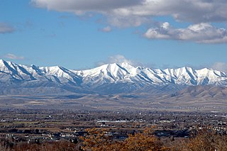
The Oquirrh Mountains is a mountain range that runs north–south for approximately 30 miles (50 km) to form the west side of Utah's Salt Lake Valley, separating it from Tooele Valley. The range runs from northwestern Utah County–central & eastern Tooele County, to the south shore of the Great Salt Lake. The highest elevation is Flat Top Mountain at 10,620 ft. The name Oquirrh was taken from the Goshute word meaning "wood sitting."

<span class="mw-page-title-main">Iosepa, Utah</span> Ghost town in Utah, United States

Iosepa is a ghost town in the Skull Valley, located approximately 75 miles (120 km) southwest of Salt Lake City in Tooele County, Utah, United States. Once home to over 200 Polynesian members of The Church of Jesus Christ of Latter-day Saints, Iosepa was inhabited during the period 1889–1917. Today, it is the site of an annual Memorial Day gathering that draws islanders and others from all over the Western United States.

<span class="mw-page-title-main">Mercur, Utah</span>

Mercur is a historical hard rock mining ghost town in Tooele County, Utah, United States. In 1891, it became the site of the first successful use of the cyanide process of gold extraction in the United States, the dominant metallurgy today. Its elevation above sea level is approximately 2,042 m. The nearby Mercur Gold Mine was re-opened by Barrick Gold in 1985, with mining operations again coming to an end in 1997. The reclamation and restoration project was set to continue up to 2010.

<span class="mw-page-title-main">Gold Hill, Utah</span> Unincorporated community in Utah, United States

Gold Hill is an unincorporated community in far western Tooele County, Utah, located near the Nevada state line.

<span class="mw-page-title-main">Mammoth, Utah</span> Unincorporated community in Utah, United States

Mammoth is an unincorporated community and semi-ghost town in northeastern Juab County, Utah, United States.

<span class="mw-page-title-main">Woodside, Utah</span> Ghost town in Utah, United States

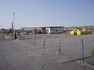
Woodside is a ghost town located on the west bank of the shallow Price River in the nearly uninhabited eastern part of Emery County, Utah, United States. Its fenced-in filling station is one of the only signs of human activity along the lonely stretch of U.S. Route 6/191 between Wellington and Green River.

Rockport is a ghost town in a narrow part of Weber Valley at the mouth of Three Mile Canyon in Summit County, Utah, United States. Located 4 miles (6.4 km) south of Wanship, it was inhabited for nearly a century before the creation of Rockport Reservoir, which covered almost the whole townsite.

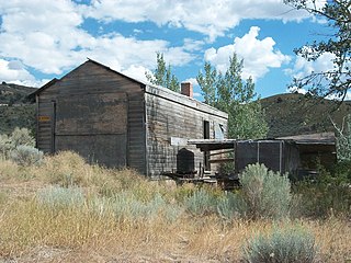
Scranton is a ghost town in Tooele County, Utah, United States. Located in Barlow Canyon near the Juab County line, it was a short-lived mining town. Scranton has been uninhabited for over a century, but some of its structures have survived relatively intact.

<span class="mw-page-title-main">Paria, Utah</span> Ghost town in Utah, United States

Paria or Pahreah, is a ghost town on the Paria River in Grand Staircase–Escalante National Monument in central Kane County, Utah, United States. It was inhabited from 1870 to 1929, and later used as a filming location.

Castleton is a ghost town in the Castle Valley in southeastern Grand County, Utah, United States.

<span class="mw-page-title-main">Giles, Utah</span> Ghost town in Utah, United States

Giles is a ghost town located along the Fremont River in the Blue Valley of Wayne County, Utah, United States. The town was inhabited circa 1883–1919.

Lake Point is an unincorporated community on the eastern edge of northern Tooele County, Utah, United States.

<span class="mw-page-title-main">Silver Reef, Utah</span> Ghost town in Utah, United States

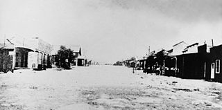
Silver Reef is a ghost town in Washington County, Utah, United States, about 15 miles (24 km) northeast of St. George and 1 mile (1.6 km) west of Leeds. Silver Reef was established after John Kemple, a prospector from Nevada, discovered a vein of silver in a sandstone formation in 1866. At first, geologists were uncertain about Kemple's find because silver is not usually found in sandstone. In 1875, two bankers from Salt Lake City sent William Barbee to the site to stake mining claims. He staked 21 claims, and an influx of miners came to work Barbee's claims and to stake their own. To accommodate the miners, Barbee established a town called Bonanza City. Property values there were high, so several miners settled on a ridge to the north of it and named their settlement Rockpile. The town was renamed Silver Reef after silver mines in nearby Pioche closed and businessmen arrived.

Knolls is an unincorporated community in north-central Tooele County, Utah, United States.

Arinosa is a ghost town located in Tooele County, Utah, United States. Arinosa is 19 miles east of Wendover and 100 miles west of Salt Lake City, in the middle of the Great Salt Lake Desert. Although it lies along the route of the current Interstate 80, there is no exit providing access to the area.

<span class="mw-page-title-main">Salduro, Utah</span> Ghost town in Utah, United States

Salduro is a ghost town located in Tooele County, Utah, United States.

References

  1. 1 2 3 4 5 6 7 Carr, Stephen L. (1986) [June 1972]. The Historical Guide to Utah Ghost Towns (3rd ed.). Salt Lake City, Utah: Western Epics. pp. 29–30. ISBN   0-914740-30-X.
  2. Van Cott, John W. (1990). Utah Place Names. Salt Lake City, Utah: University of Utah Press. p. 3. ISBN   0-87480-345-4.
  3. 1 2 3 4 Sharp, William H. "The Ajax Store". Northwest Utah Heritage. Archived from the original on November 17, 2008. Retrieved February 20, 2008.
  4. 1 2 3 4 Thompson, George A. (November 1982). Some Dreams Die: Utah's Ghost Towns and Lost Treasures. Salt Lake City: Dream Garden Press. pp. 19–20. ISBN   0-942688-01-5.
  5. Blanthorn, Ouida (January 1998). A History of Tooele County (PDF). Utah Centennial County History Series. Salt Lake City, Utah: Utah State Historical Society. p. 305. ISBN   0-913738-44-1 . Retrieved July 15, 2012.