Vernon, Utah

Last updated

Vernon, Utah
Vernon public school.jpg
Vernon Elementary School, January 2009
Etymology: Joseph Vernon
Tooele County Utah incorporated and unincorporated areas Vernon highlighted.svg
Location of Vernon within Tooele County and Utah
Map of USA UT.svg
Location of Utah within the United States
Coordinates: 40°5′45″N112°27′0″W / 40.09583°N 112.45000°W / 40.09583; -112.45000
Country United States
State Utah
County Tooele
Settled1857
Incorporated (Onaqui)1934
Incorporated (Vernon)22 February 1972
Named for Joseph Vernon
Area
[1]
  Total8.06 sq mi (20.88 km2)
  Land8.06 sq mi (20.88 km2)
  Water0.00 sq mi (0.00 km2)
Elevation
5,515 ft (1,681 m)
Population
 (2010)
  Total243
  Estimate 
(2019) [2]
356
  Density44.16/sq mi (17.05/km2)
Time zone UTC-7 (Mountain (MST))
  Summer (DST) UTC-6 (MDT)
ZIP code
84080
Area code 435
FIPS code 49-80200 [3]
GNIS feature ID1446932 [4]

Vernon is a town in southeastern Tooele County, Utah, United States. [4]

Contents

Description

The town located along Utah State Route 36 in southern Rush Valley [5] and is part of the Salt Lake City Metropolitan Statistical Area. The population was 236 at the 2000 census.

Vernon is the birthplace of World War II Medal of Honor recipient Mervyn Sharp Bennion.

Geography

According to the United States Census Bureau, the town has a total area of 7.5 square miles (19 km2), all land.

Climate

The climate in this area is characterized by hot, humid summers and generally mild to cool winters. According to the Köppen Climate Classification system, Vernon has a hot-summer mediterranean continental climate, abbreviated "Dsa" on climate maps. [6] The hottest temperature recorded in Vernon was 106 °F (41.1 °C) on July 13, 2002, and June 24, 2007, while the coldest temperature recorded was −26 °F (−32.2 °C) on December 23, 1990. [7]

Climate data for Vernon, Utah, 1991–2020 normals, extremes 1953–present
MonthJanFebMarAprMayJunJulAugSepOctNovDecYear
Record high °F (°C)63
(17)
67
(19)
81
(27)
86
(30)
96
(36)
106
(41)
106
(41)
102
(39)
99
(37)
89
(32)
77
(25)
76
(24)
106
(41)
Mean maximum °F (°C)53.7
(12.1)
57.7
(14.3)
69.2
(20.7)
76.7
(24.8)
85.4
(29.7)
94.5
(34.7)
99.1
(37.3)
97.1
(36.2)
91.4
(33.0)
81.3
(27.4)
67.3
(19.6)
56.1
(13.4)
99.8
(37.7)
Average high °F (°C)39.4
(4.1)
43.9
(6.6)
52.1
(11.2)
58.4
(14.7)
69.4
(20.8)
81.0
(27.2)
90.1
(32.3)
88.2
(31.2)
78.6
(25.9)
64.4
(18.0)
50.4
(10.2)
39.2
(4.0)
62.9
(17.2)
Daily mean °F (°C)25.7
(−3.5)
30.1
(−1.1)
37.9
(3.3)
43.5
(6.4)
52.9
(11.6)
63.0
(17.2)
71.5
(21.9)
69.7
(20.9)
60.3
(15.7)
47.4
(8.6)
35.2
(1.8)
25.7
(−3.5)
46.9
(8.3)
Average low °F (°C)12.0
(−11.1)
16.3
(−8.7)
23.7
(−4.6)
28.7
(−1.8)
36.3
(2.4)
44.9
(7.2)
52.8
(11.6)
51.2
(10.7)
42.0
(5.6)
30.3
(−0.9)
20.0
(−6.7)
12.2
(−11.0)
30.9
(−0.6)
Mean minimum °F (°C)−4.5
(−20.3)
−1.0
(−18.3)
9.7
(−12.4)
17.0
(−8.3)
24.9
(−3.9)
32.9
(0.5)
43.0
(6.1)
41.6
(5.3)
29.7
(−1.3)
17.8
(−7.9)
2.9
(−16.2)
−3.8
(−19.9)
−9.5
(−23.1)
Record low °F (°C)−22
(−30)
−25
(−32)
−10
(−23)
3
(−16)
16
(−9)
22
(−6)
35
(2)
24
(−4)
16
(−9)
−4
(−20)
−16
(−27)
−26
(−32)
−26
(−32)
Average precipitation inches (mm)0.77
(20)
0.90
(23)
1.00
(25)
1.09
(28)
1.29
(33)
0.71
(18)
0.70
(18)
0.71
(18)
0.83
(21)
1.07
(27)
0.76
(19)
0.77
(20)
10.60
(269)
Average snowfall inches (cm)8.4
(21)
9.5
(24)
3.9
(9.9)
2.3
(5.8)
0.0
(0.0)
0.0
(0.0)
0.0
(0.0)
0.0
(0.0)
0.0
(0.0)
0.9
(2.3)
4.8
(12)
6.6
(17)
36.4
(92)
Average precipitation days (≥ 0.01 in)5.65.76.37.17.73.84.14.74.24.74.94.863.6
Average snowy days (≥ 0.1 in)3.93.52.51.10.00.00.00.00.00.52.43.617.5
Source 1: NOAA [8]
Source 2: National Weather Service [7]

History

The Vernon area was settled beginning in 1857. The community has the name of Joseph Vernon, a pioneer settler. [9] [10] In 1934, a very large incorporated town called Onaqui was created in the area, including Vernon as well as the settlements of Clover and St. John. Vernon was far from the rest of Onaqui, and locals always looked on it as somewhat independent. Vernon residents were granted a petition to incorporate separately on February 22, 1972, and the remaining part of Onaqui was renamed Rush Valley.

Demographics

Historical population
CensusPop.Note
1870 111
1880 18163.1%
1890 24937.6%
1900 196−21.3%
1910 36586.2%
1920 275−24.7%
1930 34124.0%
1980 181
1990 1810.0%
2000 23630.4%
2010 2433.0%
2019 (est.)356 [2] 46.5%
U.S. Decennial Census [11]

As of the census [3] of 2000, there were 236 people, 77 households, and 59 families residing in the town. The population density was 31.4 people per square mile (12.1/km2). There were 86 housing units at an average density of 11.4 per square mile (4.4/km2). The racial makeup of the town was 94.07% White, 0.42% African American, 0.42% Asian, 2.54% from other races, and 2.54% from two or more races. Hispanic or Latino of any race were 4.66% of the population.

There were 77 households, out of which 42.9% had children under the age of 18 living with them, 68.8% were married couples living together, 7.8% had a female householder with no husband present, and 22.1% were non-families. 20.8% of all households were made up of individuals, and 9.1% had someone living alone who was 65 years of age or older. The average household size was 3.06 and the average family size was 3.62.

In the town, the population was spread out, with 34.7% under the age of 18, 10.2% from 18 to 24, 22.5% from 25 to 44, 21.6% from 45 to 64, and 11.0% who were 65 years of age or older. The median age was 30 years. For every 100 females, there were 91.9 males. For every 100 females age 18 and over, there were 94.9 males.

The median income for a household in the town was $42,500, and the median income for a family was $43,500. Males had a median income of $38,333 versus $22,500 for females. The per capita income for the town was $13,053. About 10.7% of families and 13.2% of the population were below the poverty line, including 21.5% of those under the age of eighteen and 3.8% of those 65 or over.

See also

Related Research Articles

<span class="mw-page-title-main">Morgan County, Utah</span> County in Utah, United States

Morgan County is a county in northern Utah, United States. As of the 2020 census, the population was 12,295. Its county seat and largest city is Morgan. Morgan County is part of the Ogden-Clearfield, UT Metropolitan Statistical Area as well as the Salt Lake City-Provo-Orem, UT Combined Statistical Area.

<span class="mw-page-title-main">Wasatch County, Utah</span> County in Utah, United States

Wasatch County is a county in the U.S. state of Utah. As of the 2020 United States Census, the population was 34,788. Its county seat and largest city is Heber City. The county was named for a Ute word meaning "mountain pass" or "low place in the high mountains".

<span class="mw-page-title-main">Manila, Utah</span> Town in the state of Utah, United States

Manila is a small city located on the northern edge of Daggett County, Utah, United States, just south of the Wyoming border. The town is at the junction of State Route 43 and State Route 44, and is the county seat of Daggett County. Nearby sites include the Flaming Gorge National Recreation Area and the Flaming Gorge Reservoir just east of town, and to the south is Ashley National Forest, which includes Kings Peak (13,528 ft), the highest point in Utah.

<span class="mw-page-title-main">Syracuse, Utah</span> City in Utah, United States

Syracuse is a city in Davis County, Utah, United States. It is situated between the Great Salt Lake and Interstate 15, about 30 miles (48 km) north of Salt Lake City. It is part of the Ogden–Clearfield, Utah Metropolitan Statistical Area. The city has seen rapid growth and development since the 1990s. The city population was 24,331 at the time of the 2010 census, an increase of 158.9% since the 2000 census.

<span class="mw-page-title-main">Woods Cross, Utah</span> City in Utah, United States

Woods Cross is a city in Davis County, Utah, United States. It is part of the Ogden–Clearfield, Utah Metropolitan Statistical Area. The population was 9,761 as of the 2010 census, with an estimated population in 2019 of 11,431.

<span class="mw-page-title-main">Levan, Utah</span> Town in Utah, United States

Levan is a town in Juab County, Utah, United States. As of the 2020 census it had a population of 862.

<span class="mw-page-title-main">Hinckley, Utah</span> Town in the state of Utah, United States

Hinckley is a town in Millard County, Utah, United States, in the middle of the Sevier Desert. Irrigation water from the Sevier River, passing nearby, has been used to turn Hinckley into a farming oasis. The mountains that are common in Utah are seen only in the distance, and beyond the reach of the river, a severe desert prevails. The population was 696 at the 2010 census.

<span class="mw-page-title-main">Lynndyl, Utah</span> Town in the state of Utah, United States

Lynndyl is a town in Millard County, Utah, United States. The population was 106 at the 2010 census.

<span class="mw-page-title-main">Scipio, Utah</span> Town in the state of Utah, United States

Scipio is a town on the eastern edge of Millard County, Utah, United States. The population was 290 at the 2000 census.

<span class="mw-page-title-main">Randolph, Utah</span> Town in the state of Utah, United States

Randolph is a town in Rich County, Utah, United States and as of the 2010 census, the town population was 464. It is the county seat of Rich County. Randolph had the highest percentage of people of any city in the country vote for George W. Bush in the 2004 election, at 95.6% Randolph's municipal classification was officially changed from a city to a town on January 1, 2009. The controversial WWASPS boarding school Old West Academy is located just outside Randolph.

<span class="mw-page-title-main">Aneth, Utah</span> CDP in Utah, United States

Aneth is a census-designated place (CDP) in San Juan County, Utah, United States. The population was 598 at the 2000 census. The origin of the name Aneth is obscure.

<span class="mw-page-title-main">Blanding, Utah</span> City in Utah, United States

Blanding is a city in San Juan County, Utah, United States. The population was 3,375 at the 2010 census, making it the most populated city in San Juan County. It was settled in the late 19th century by Mormon settlers, predominantly from the famed Hole-In-The-Rock expedition. Economic contributors include mineral processing, mining, agriculture, local commerce, tourism, and transportation.

<span class="mw-page-title-main">Coalville, Utah</span> City in the United States

Coalville is a city in and the county seat of Summit County, Utah, United States. It is part of the Salt Lake City, Utah Metropolitan Statistical Area. The population was 1,363 as of the 2010 census. Interstate 80 passes through the town, as well as the Weber River, which flows into Echo Reservoir, just north of Coalville.

<span class="mw-page-title-main">Francis, Utah</span> Town in the state of Utah, United States

Francis is a town in on the western edge of Summit County, Utah, United States. It is part of the Salt Lake City, Utah Metropolitan Statistical Area. The population was 1,077 at the 2010 census.

<span class="mw-page-title-main">Henefer, Utah</span> Town in Utah, United States

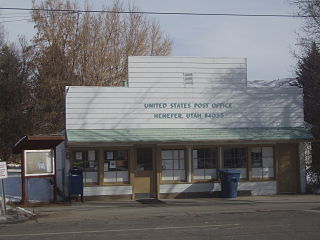
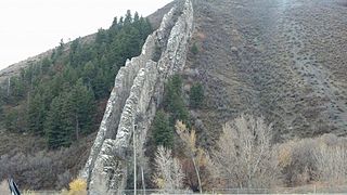
Henefer is a town in Summit County, Utah, United States. It is part of the Salt Lake City, Utah Metropolitan Statistical Area. The population was 766 at the 2010 census.

<span class="mw-page-title-main">Kamas, Utah</span> City in Utah, United States

Kamas is a city in southwestern Summit County, Utah, United States. The population was 1,811 at the 2010 census. It is located 42 miles (68 km) east of downtown Salt Lake City. The main industries are cattle ranching and lumber. The town is known as "The Gateway to the Uinta Mountains".

<span class="mw-page-title-main">Rush Valley, Utah</span> Town in the state of Utah, United States

Rush Valley is a town in Tooele County, Utah, United States, located in the northwest of Rush Valley. It is part of the Salt Lake City, Utah Metropolitan Statistical Area. The population was 447 at the 2010 census, with an estimate population of 494 in 2019.

<span class="mw-page-title-main">Leeds, Utah</span> Town in Washington County, Utah

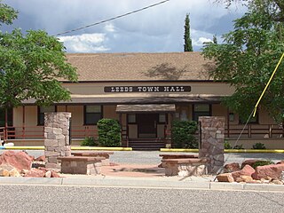
Leeds is a town in Washington County, Utah, United States. The population was 820 at the 2010 census.

<span class="mw-page-title-main">Huntsville, Utah</span> Town in the state of Utah, United States

Huntsville is a town in Weber County, Utah, United States. The population was 608 at the 2010 census. It is located in Ogden Valley. It is part of the Ogden–Clearfield, Utah Metropolitan Statistical Area, as well as the Ogden Valley census county division.

<span class="mw-page-title-main">Uintah, Utah</span> City in Utah, United States

Uintah is a city in Weber County, Utah, United States. The population was 1,322 at the 2010 census. It is part of the Ogden–Clearfield, Utah Metropolitan Statistical Area. Although Uintah was a town in 2000, it has since been classified as a fifth-class city by state law.

References

  1. "2019 U.S. Gazetteer Files". United States Census Bureau. Retrieved August 7, 2020.
  2. 1 2 "Population and Housing Unit Estimates". United States Census Bureau. May 24, 2020. Retrieved May 27, 2020.
  3. 1 2 "U.S. Census website". United States Census Bureau . Retrieved January 31, 2008.
  4. 1 2 "Vernon". Geographic Names Information System . United States Geological Survey, United States Department of the Interior.
  5. "MyTopo Maps - Vernon, UT, USA" (Map). mytopo.com. Trimble Navigation, Ltd. Retrieved March 11, 2018.
  6. Climate Summary for Vernon, Utah
  7. 1 2 "NOAA Online Weather Data - NWS Salt Lake City". National Weather Service. Retrieved October 28, 2022.
  8. "U.S. Climate Normals Quick Access - Station: Vernon, UT". National Oceanic and Atmospheric Administration. Retrieved October 28, 2022.
  9. Lund, Anthon Henrik (1922). The Utah Genealogical and Historical Magazine. Genealogical Society of Utah. p. 38.
  10. Van Cott, John W. (1990). Utah Place Names: A Comprehensive Guide to the Origins of Geographic Names: A Compilation. Salt Lake City: University of Utah Press. p. 384. ISBN   978-0-87480-345-7. OCLC   797284427 . Retrieved March 11, 2018.
  11. "Census of Population and Housing". Census.gov. Retrieved 4 June 2015.

Commons-logo.svg Media related to Vernon, Utah at Wikimedia Commons