Grantsville, Utah

Last updated

Grantsville, Utah
Grantsville Utah City Office.jpeg
Grantsville City Office
Tooele County Utah incorporated and unincorporated areas Grantsville highlighted.svg
Location in Tooele County and the state of Utah
Map of USA UT.svg
Location of Utah in the United States
Coordinates: 40°35′45″N112°27′55″W / 40.59583°N 112.46528°W / 40.59583; -112.46528
Country United States
State Utah
County Tooele
Settled1848
Named for George D. Grant
Area
[1]
  Total37.59 sq mi (97.36 km2)
  Land37.47 sq mi (97.05 km2)
  Water0.12 sq mi (0.30 km2)
Elevation
4,304 ft (1,312 m)
Population
 (2020)
  Total12,617
  Estimate 
(2019) [2]
12,064
  Density335.65/sq mi (129.59/km2)
Time zone UTC-7 (Mountain (MST))
  Summer (DST) UTC-6 (MDT)
ZIP code
84029
Area code 435
FIPS code 49-31120 [3]
GNIS feature ID1428338 [4]
Website Official website

Grantsville is the second most populous city in Tooele County, Utah, United States. It is part of the Salt Lake City, Utah Metropolitan Statistical Area. The population was 12,617 at the 2020 census. The city has grown slowly and steadily throughout most of its existence, but rapid increases in growth occurred during the 1970s, 1990s, and 2010s. Recent rapid growth has been attributed to being close to Salt Lake City, small town community feel, lower housing costs than Salt Lake County, the nearby Deseret Peak recreational center, the Utah Motorsports Campus raceway, and the newly built Wal-Mart distribution center located just outside the city. It is quickly becoming a bedroom community for commuters into the Salt Lake Valley.

Contents

History

The area of Grantsville was originally populated by the Goshute tribe. [5]

Grantsville was originally called "Willow Creek", and has also been called "Twenty Wells" due to the natural wells that give fresh water to the area. Grantsville was settled by Mormon pioneers in 1850, with the arrival of the brothers-in-law James McBride and Harrison Severe, with their wives and families. [6] [7] The present name, after Col. George D. Grant, a leader in the Church of Jesus Christ of Latter-day Saints, was adopted c. 1853. [6] A post office called Grantsville has been in operation since 1864. [8] The Anderson–Clark Farmstead has outbuildings dating back from 1880, and was first owned by the pioneer James McBride.

Geography

Grantsville is bordered on the south by South Mountain, which separates Rush Valley from Tooele Valley. To the north is Stansbury Island, and on the east are the Oquirrh Mountains and the Great Salt Lake, and on the west side the Stansbury Mountains. SR-138 passes through the city, heading northwest to intersect with I-80 and east to Stansbury Park.

The climate is hot during the summer and cold and snowy during the winter. Although Grantsville can be affected by lake-effect snow from the Great Salt Lake, most of the time, it is too far southwest.

According to the United States Census Bureau, the city has a total area of 19.34 square miles (50.1 km2), of which 19.2 square miles (50 km2) is land and 0.04 square miles (0.10 km2) (0.22%) is water.

Demographics

Historical population
CensusPop.Note
1860 451
1870 75567.4%
1880 1,00733.4%
1890 979−2.8%
1900 1,0588.1%
1910 1,1549.1%
1920 1,2135.1%
1930 1,201−1.0%
1940 1,2423.4%
1950 1,53723.8%
1960 2,16640.9%
1970 2,93135.3%
1980 4,41950.8%
1990 4,5001.8%
2000 6,01533.7%
2010 8,89347.8%
2020 12,61741.9%
Source: U.S. Census Bureau [9]

As of the 2020 census, there were 12,617 people, and 3,855 households in the city. The population density was 335.65 people per square mile (129.59/km2). The racial makeup of the city was 91.2% White, 0.2% African American, 0.6% Native American, 0.3% Asian, 0.2% Pacific Islander, 2.1% some other race, and 5.5% from two or more races. Hispanic or Latino of any race were 7.3% of the population.

Recorded in the 2020 census: [3] There were 3,855 household units, out of which 68.8% were married couples living together, 9.0% had a male householder with no spouse present, and 14.4% had a female householder with no spouse. 7.8% of all households were made up of individuals. The average family size was 3.69. The median age was 27.9 years. 8.1% of the population was 65 years and older. 6.8% of the population was veterans.

The median income for a household in the city was $84,293. 5.0% of the population were below the poverty line.

24.9% of the population has a Bachelor's Degree or higher. The School Enrolled Population Enrolled in Kindergarten to 12th Grade is 79.0%.

Employment: 72.8% of employees are private company workers, 16.8% government workers, 5.9% private not-for-profit workers, 3.4% self-employed in not owned business, and 1.1% self-employed in own business.

Education

Grantsville is in the Tooele County School District and has three elementary schools (Grantsville, Twenty Wells, and Willow), Grantsville Junior High School, and Grantsville High School. There are also a few preschools.

Due to a fire on July 13, 2009, Grantsville Elementary School was forced to close until a new elementary school was built. [10] The new school opened for the 2011–2012 school year.

Events

The Old Folks Sociable is the traditional social event of the year. The Old Folks Sociable idea started in 1875 when professional photographer Charles Savage and LDS Church Presiding Bishop Edward Hunter inaugurated "Old Folks Day" to honor fathers and mothers. The first Old Folks Sociable held in Grantsville was on January 6, 1884. This annual event is believed to have been canceled only twice in its 125-year history. [11]

The Old Folks Sociable honors all residents and former residents who are 75 years older. Grantsville High School, home to the Old Folks Sociable, becomes a gathering place for high school class reunions and family reunions. The Sociable is also a celebration of Grantsville's heritage. For residents and former residents, it is a walk down memory lane. Events include a 5K run, a car show, a program, a reception for honored guests, a dinner, and a dance. All residents and former (eighteen years and older) are invited to attend. The Old Folks Sociable is held each year during the month of March. [12]

Notable people

Related Research Articles

<span class="mw-page-title-main">Juab County, Utah</span> County in Utah, United States

Juab County is a county in western Utah, United States. As of the 2020 United States Census, the population was 11,786. Its county seat and largest city is Nephi.

<span class="mw-page-title-main">Tooele County, Utah</span> County in Utah, United States

Tooele County is a county in the U.S. state of Utah. As of the 2020 United States Census, the population was 72,698. Its county seat and largest city is Tooele. The county was created in 1850 and organized the following year.

<span class="mw-page-title-main">Corinne, Utah</span> City in Utah, United States

Corinne is a city in Box Elder County, Utah, United States. The population was 809 at the 2020 census, up from the 2010 figure of 685.

<span class="mw-page-title-main">Layton, Utah</span> City in Utah, United States

Layton (/ˈleɪʔɪn/) is a city in Davis County, Utah, United States. It is part of the Ogden-Clearfield Metropolitan Statistical Area. As of the 2020 census, the city had a population of 81,773, with 2022 Census Bureau estimates showing an increase to 82,601. Layton is the most populous city in Davis County and the tenth most populous in Utah.

<span class="mw-page-title-main">Woods Cross, Utah</span> City in Utah, United States

Woods Cross is a city in Davis County, Utah, United States. It is part of the Ogden–Clearfield, Utah Metropolitan Statistical Area. The population was 9,761 as of the 2010 census, with an estimated population in 2019 of 11,431.

<span class="mw-page-title-main">Lynndyl, Utah</span> Town in the state of Utah, United States

Lynndyl is a town in Millard County, Utah, United States. The population was 106 at the 2010 census.

<span class="mw-page-title-main">Gunnison, Utah</span> City in Utah, United States

Gunnison is a city in the Sevier Valley in southwestern Sanpete County, Utah, United States. The population was 3,509 at the 2020 census. The city was named in honor of John W. Gunnison, a United States Army officer who surveyed for the transcontinental railroad in 1853.

<span class="mw-page-title-main">Coalville, Utah</span> City in the United States

Coalville is a city in and the county seat of Summit County, Utah, United States. It is part of the Salt Lake City, Utah Metropolitan Statistical Area. The population was 1,486 as of the 2020 census. Interstate 80 passes through the town, as well as the Weber River, which flows into Echo Reservoir, just north of Coalville.

<span class="mw-page-title-main">Dugway, Utah</span> CDP in Utah, United States

Dugway is a census-designated place (CDP) in southeastern Tooele County, Utah, United States. The population was 2,016, at the 2000 census, a modest increase over the 1990 figure of 1,761. The town is located inside the United States Army's large weapons testing facility, Dugway Proving Ground, making it a closed city, as the only roads leading to the town pass through military checkpoints at the boundaries of the base. Non-resident civilians must request advance authorization to enter the town. The housing area designated for military and civilian personnel is referred to as "English Village."

<span class="mw-page-title-main">Erda, Utah</span> City in Utah, United States

Erda is a city in Tooele County, Utah, United States. The population was 4,642 at the 2010 census, a significant increase from the 2000 figure of 2,473. Erda was previously a Census Designated Place (CDP) and a township but officially received its incorporation certificate in January 2022.

<span class="mw-page-title-main">Ophir, Utah</span> CDP in Utah, United States

Ophir is a census-designated place in Tooele County, Utah, United States. It is part of the Salt Lake City, Utah Metropolitan Statistical Area. The population was 23 at the 2000 census, a decrease of two from the 1990 figure of 25.

<span class="mw-page-title-main">Stansbury Park, Utah</span> CDP and Township in Utah, United States

Stansbury Park is a census-designated place (CDP) in Tooele County, Utah, United States. As of the 2020 United States Census, the population was 9,851, up from the 2010 figure of 5,145.

<span class="mw-page-title-main">Stockton, Utah</span> Town in the state of Utah, United States

Stockton is a town in Tooele County, Utah, United States. It is part of the Salt Lake City, Utah Metropolitan Statistical Area. The population was 616 at the 2010 census.

<span class="mw-page-title-main">Tooele, Utah</span> City in Utah, United States

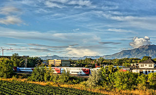
Tooele is a city in Tooele County in the U.S. state of Utah. The population was 35,742 at the 2020 census. It is the county seat of Tooele County. Located approximately 30 minutes southwest of Salt Lake City, Tooele is known for Tooele Army Depot, for its views of the nearby Oquirrh Mountains and the Great Salt Lake.

<span class="mw-page-title-main">Vernon, Utah</span> Town in the state of Utah, United States

Vernon is a town in southeastern Tooele County, Utah, United States.

<span class="mw-page-title-main">Wendover, Utah</span> City in Utah, United States

Wendover is a city on the western edge of Tooele County, Utah, United States. The population was 1,115 at the 2020 census.

<span class="mw-page-title-main">Saratoga Springs, Utah</span> City in Utah, United States

Saratoga Springs is a city in Utah County, Utah, United States. The elevation is 4,505 feet. It is part of the Provo–Orem, Utah Metropolitan Statistical Area. The city is a relatively new development along the northwestern shores of Utah Lake. It was incorporated on December 31, 1997 and has been growing rapidly since then. The population was 37,696 at the 2020 Census. Saratoga Springs became a city in 2001.

<span class="mw-page-title-main">Vineyard, Utah</span> City in Utah, United States

Vineyard is a city in Utah County, Utah, United States. It is part of the Provo–Orem Metropolitan Statistical Area. The population grew from 139 at the 2010 census to 12,543 at the 2020 census making it the fastest growing city in Utah and one of the fastest-growing cities in the nation during that timeframe. Population has grown dramatically since about 2012 due to redevelopment of the former Geneva Steel site which sits in Vineyard.

<span class="mw-page-title-main">Deseret Peak Wilderness</span> Wilderness area in Utah, United States

The Deseret Peak Wilderness is located in the Stansbury Mountains of Tooele County, Utah, United States near the towns of Tooele and Grantsville, not far from the Great Salt Lake. It is part of the Wasatch-Cache National Forest. This semi-arid wilderness is part of the Great Basin ecosystem. Elevations range from about 6,000 feet to the top of Deseret Peak's limestone escarpment at 11,031 feet (3,362 m). In this high country, with barren Skull Valley to the west, you'll find some springs and intermittent creeks, despite the general dryness of the area.

Tooele County School District is a school district headquartered in Tooele, Utah.

References

  1. "2019 U.S. Gazetteer Files". United States Census Bureau. Retrieved August 7, 2020.
  2. "Population and Housing Unit Estimates". United States Census Bureau. May 24, 2020. Retrieved May 27, 2020.
  3. 1 2 "U.S. Census website". United States Census Bureau . Retrieved January 31, 2008.
  4. "US Board on Geographic Names". United States Geological Survey. October 25, 2007. Retrieved January 31, 2008.
  5. Dennis R. Defa. "Goshute Indians". Utah History Encyclopedia.
  6. 1 2 The Utah Genealogical and Historical Magazine, Volumes 9-10. 1918. p. 184.
  7. "Grantsville History". Grantsville Official Site. citing "The Founding and Development of Grantsville, Utah, 1850-1950", a Theses and Dissertation by Alma A. Gardiner in 1959
  8. "Post Offices" . Retrieved January 22, 2018.
  9. "Census of Population and Housing". U.S. Census Bureau. Retrieved December 22, 2022.
  10. Gillie, Tim (July 21, 2009). "After-fire plan set for Grantsville Elementary School students". Tooele Transcript Bulletin. Utah. Retrieved September 16, 2009.
  11. "Town Tradition Bridges Old and New," Deseret News, March 17, 2009.
  12. "Glimpses of Grantsville," Tooele Transcript Bulletin (Utah), March 27, 2008.