Grade (slope)

Last updated

d = run
Dh = rise
l = slope length
a = angle of inclination Grade dimension.svg
d = run
Δh = rise
l = slope length
α = angle of inclination

The grade (US) or gradient (UK) (also called stepth, slope, incline, mainfall, pitch or rise) of a physical feature, landform or constructed line refers to the tangent of the angle of that surface to the horizontal. It is a special case of the slope, where zero indicates horizontality. A larger number indicates higher or steeper degree of "tilt". Often slope is calculated as a ratio of "rise" to "run", or as a fraction ("rise over run") in which run is the horizontal distance (not the distance along the slope) and rise is the vertical distance.

Contents

Slopes of existing physical features such as canyons and hillsides, stream and river banks and beds are often described as grades, but typically the word "grade" is used for human-made surfaces such as roads, landscape grading, roof pitches, railroads, aqueducts, and pedestrian or bicycle routes. The grade may refer to the longitudinal slope or the perpendicular cross slope.

Nomenclature

Illustration of grades (percentages), angles in degrees and ratio. Slope quadrant.svg
Illustration of grades (percentages), angles in degrees and ratio.
A tram and gradient sign in Gdansk, Poland. The 50%0 grade is equivalent to 50 m/km or 5%. 50 per mille.png
A tram and gradient sign in Gdańsk, Poland. The 50‰ grade is equivalent to 50 m/km or 5%.

There are several ways to express slope:

  1. as an angle of inclination to the horizontal. (This is the angle α opposite the "rise" side of a triangle with a right angle between vertical rise and horizontal run.)
  2. as a percentage , the formula for which is which is equivalent to the tangent of the angle of inclination times 100. In Europe and the U.S. percentage "grade" is the most commonly used figure for describing slopes.
  3. as a per mille figure (denoted with the symbol ), the formula for which is which could also be expressed as the tangent of the angle of inclination times 1000. This is commonly used in Europe to denote the incline of a railway. It is sometimes written as mm/m or m/km instead of the ‰ symbol. [1] [2]
  4. as a ratio of one part rise to so many parts run. For example, a slope that has a rise of 5 feet for every 1000 feet of run would have a slope ratio of 1 in 200. (The word "in" is normally used rather than the mathematical ratio notation of "1:200".) This is generally the method used to describe railway grades in Australia and the UK. It is used for roads in Hong Kong, and was used for roads in the UK until the 1970s.
  5. as a ratio of many parts run to one part rise, which is the inverse of the previous expression (depending on the country and the industry standards). For example, "slopes are expressed as ratios such as 4:1. This means that for every 4 units (feet or metres) of horizontal distance there is a 1 unit (foot or metre) vertical change either up or down." [3]

Any of these may be used. Grade is usually expressed as a percentage, but this is easily converted to the angle α by taking the inverse tangent of the standard mathematical slope, which is rise / run or the grade / 100. If one looks at red numbers on the chart specifying grade, one can see the quirkiness of using the grade to specify slope; the numbers go from 0 for flat, to 100% at 45 degrees, to infinity as it approaches vertical.

Slope may still be expressed when the horizontal run is not known: the rise can be divided by the hypotenuse (the slope length). This is not the usual way to specify slope; this nonstandard expression follows the sine function rather than the tangent function, so it calls a 45 degree slope a 71 percent grade instead of a 100 percent. But in practice the usual way to calculate slope is to measure the distance along the slope and the vertical rise, and calculate the horizontal run from that, in order to calculate the grade (100% × rise/run) or standard slope (rise/run). When the angle of inclination is small, using the slope length rather than the horizontal displacement (i.e., using the sine of the angle rather than the tangent) makes only an insignificant difference and can then be used as an approximation. Railway gradients are often expressed in terms of the rise in relation to the distance along the track as a practical measure. In cases where the difference between sin and tan is significant, the tangent is used. In either case, the following identity holds for all inclinations up to 90 degrees: . Or more simply, one can calculate the horizontal run by using the Pythagorean theorem, after which it is trivial to calculate the (standard math) slope or the grade (percentage).

In Europe, road gradients are signed as a percentage. [4]

Equations

Grades are related using the following equations with symbols from the figure at top.

Tangent as a ratio

The slope expressed as a percentage can similarly be determined from the tangent of the angle:

Angle from a tangent gradient

If the tangent is expressed as a percentage, the angle can be determined as:

If the angle is expressed as a ratio (1 in n) then:

Example slopes comparing the notations

For degrees, percentage (%) and per-mille (‰) notations, larger numbers are steeper slopes. For ratios, larger numbers n of 1 in n are shallower, easier slopes.

The examples show round numbers in one or more of the notations and some documented and reasonably well known instances.

Examples of slopes in the various notations
DegreesPercentage (%)Permillage (‰)RatioRemarks
60°173%1732‰1 in 0.58
47.7°110%1100‰1 in 0.91 Stoosbahn (funicular railway)
45°100%1000‰1 in 1
30.1°58%580‰1 in 1.724 Lynton and Lynmouth Cliff Railway (funicular railway)
30°58%577‰1 in 1.73
25.5°47%476‰1 in 2.1 Pilatus Railway (steepest rack railway)
20.3°37%370‰1 in 2.70 Mount Washington Cog Railway (maximum grade)
20°36%363‰1 in 2.75
18.4°33%333‰1 in 3
16.9°30%300‰1 in 3.3Extremely steep road
30% warning (France) Pente30%25.jpg
30% warning (France)
14.0°25%250‰1 in 4Very steep road. Mount Washington Cog Railway (average grade)
25% warning (Wales) Devil's Staircase Wales.jpg
25% warning (Wales)
11.3°20%200‰1 in 5Steep road
20% warning (North Yorkshire) Steep Hill sign on Henside Road - geograph.org.uk - 680341.jpg
20% warning (North Yorkshire)
8.13°14.2%142‰1 in 7
7.12°12.5%125‰1 in 8 Cable incline on the Cromford and High Peak Railway
5.71°10%100‰1 in 10Steep road
10% warning (Netherlands) Nederlands verkeersbord J6.svg
10% warning (Netherlands)
4.0°7%70‰1 in 14.3
3.37°5.9%59‰1 in 17Swannington incline on the Leicester and Swannington Railway
2.86°5%50‰1 in 20 Matheran Hill Railway. The incline from the Crawlerway at the Kennedy Space Center to the launch pads. [5] [6]
2.29°4%40‰1 in 25 Cologne–Frankfurt high-speed rail line
2.0°3.5%35‰1 in 28.57 LGV Sud-Est, LGV Est, LGV Méditerranée
1.97°3.4%34‰1 in 29Bagworth incline on the Leicester and Swannington Railway
1.89°3.3%33‰1 in 30.3Rampe de Capvern on the Toulouse–Bayonne railway  [ fr ]
1.52°2.65%26.5‰1 in 37.7 Lickey Incline
1.43°2.5%25‰1 in 40 LGV Atlantique, LGV Nord. The Schiefe Ebene.
1.146°2%20‰1 in 50Railway near Jílové u Prahy. Devonshire Tunnel
20%0 Czech Republic Sklonik-klesani.jpg
20‰ Czech Republic
0.819°1.43%14.3‰1 in 70 Waverley Route
0.716°1.25%12.5‰1 in 80Ruling grade of a secondary main line. Wellington Bank, Somerset
0.637°1.11%11.11‰1 in 90 Dove Holes Tunnel
0.573°1%10‰1 in 100 The long drag on the Settle & Carlisle line
0.458°0.8%8‰1 in 125Rampe de Guillerval
0.2865°0.5%5‰1 in 200 Paris–Bordeaux railway  [ fr ], except for the rampe de Guillerval
0.1719°0.3%3‰1 in 333
0.1146°0.2%2‰1 in 500
0.0868°0.1515%1.515‰1 in 660 Brunel's Billiard Table - Didcot to Swindon
0.0434°0.07575%0.7575‰1 in 1320 Brunel's Billiard Table - Paddington to Didcot
0%0‰1 in (infinity)Flat

Roads

In vehicular engineering, various land-based designs (automobiles, sport utility vehicles, trucks, trains, etc.) are rated for their ability to ascend terrain. Trains typically rate much lower than automobiles. The highest grade a vehicle can ascend while maintaining a particular speed is sometimes termed that vehicle's "gradeability" (or, less often, "grade ability"). The lateral slopes of a highway geometry are sometimes called fills or cuts where these techniques have been used to create them.

In the United States, maximum grade for Federally funded highways is specified in a design table based on terrain and design speeds, [7] with up to 6% generally allowed in mountainous areas and hilly urban areas with exceptions for up to 7% grades on mountainous roads with speed limits below 60 mph (95 km/h).

The steepest roads in the world according to the Guinness Book of World Records are Baldwin Street in Dunedin, New Zealand, Ffordd Pen Llech in Harlech, Wales [8] and Canton Avenue in Pittsburgh, Pennsylvania. [9] The Guinness World Record once again lists Baldwin Street as the steepest street in the world, with a 34.8% grade (1 in 2.87) after a successful appeal [10] against the ruling that handed the title, briefly, to Ffordd Pen Llech.

A number of streets elsewhere have steeper grades than those listed in the Guinness Book. Drawing on the U.S. National Elevation Dataset, 7x7 (magazine) identified ten blocks of public streets in San Francisco open to vehicular traffic in the city with grades over 30 percent. The steepest at 41 percent is the block of Bradford Street above Tompkins Avenue in the Bernal Heights neighborhood. [11] The San Francisco Municipal Railway operates bus service among the city's hills. The steepest grade for bus operations is 23.1% by the 67-Bernal Heights on Alabama Street between Ripley and Esmeralda Streets. [12]

Likewise, the Pittsburgh Department of Engineering and Construction recorded a grade of 37% (20°) for Canton Avenue. [13] The street has formed part of a bicycle race since 1983. [14]

Environmental design

Grade, pitch, and slope are important components in landscape design, garden design, landscape architecture, and architecture; for engineering and aesthetic design factors. Drainage, slope stability, circulation of people and vehicles, complying with building codes, and design integration are all aspects of slope considerations in environmental design.

Railways

Grade indicator near Bellville, Western Cape, South Africa, showing 1:150 and 1:88 grades. Track Grade indicator 150-88.JPG
Grade indicator near Bellville, Western Cape, South Africa, showing 1:150 and 1:88 grades.

Ruling gradients limit the load that a locomotive can haul, including the weight of the locomotive itself. On a 1% gradient (1 in 100) a locomotive can pull half (or less) of the load that it can pull on level track. (A heavily loaded train rolling at 20 km/h on heavy rail may require ten times the pull on a 1% upgrade that it does on the level at that speed.)

Early railways in the United Kingdom were laid out with very gentle gradients, such as 0.07575% (1 in 1320) and 0.1515% (1 in 660) on the Great Western main line, nicknamed Brunel's Billiard Table, because the early locomotives (and their brakes) were feeble. Steep gradients were concentrated in short sections of lines where it was convenient to employ assistant engines or cable haulage, such as the 1.2 kilometres (0.75 miles) section from Euston to Camden Town.

Extremely steep gradients require the use of cables (such as the Scenic Railway at Katoomba Scenic World, Australia, with a maximum grade of 122% (52°), claimed to be the world's steepest passenger-carrying funicular [15] ) or some kind of rack railway (such as the Pilatus railway in Switzerland, with a maximum grade of 48% (26°), claimed to be the world's steepest rack railway [16] ) to help the train ascend or descend.

Gradients can be expressed as an angle, as feet per mile, feet per chain, 1 in n, x% or y per mille. Since designers like round figures, the method of expression can affect the gradients selected.[ citation needed ]

A 1371-metre long stretch of railroad with a 20%0 (2%) slope, Czech Republic Sklonik-klesani.jpg
A 1371-metre long stretch of railroad with a 20 (2%) slope, Czech Republic

The steepest railway lines that do not use a rack system include:

Compensation for curvature

Gradients on sharp curves are effectively a bit steeper than the same gradient on straight track, so to compensate for this and make the ruling grade uniform throughout, the gradient on those sharp curves should be reduced slightly.

Continuous brakes

In the era before they were provided with continuous brakes, whether air brakes or vacuum brakes, steep gradients made it extremely difficult for trains to stop safely. In those days, for example, an inspector insisted that Rudgwick railway station in West Sussex be regraded. He would not allow it to open until the gradient through the platform was eased from 1 in 80 to 1 in 130.

See also

Related Research Articles

<span class="mw-page-title-main">Gradient</span> Multivariate derivative (mathematics)

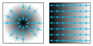
In vector calculus, the gradient of a scalar-valued differentiable function of several variables is the vector field whose value at a point gives the direction and the rate of fastest increase. The gradient transforms like a vector under change of basis of the space of variables of . If the gradient of a function is non-zero at a point , the direction of the gradient is the direction in which the function increases most quickly from , and the magnitude of the gradient is the rate of increase in that direction, the greatest absolute directional derivative. Further, a point where the gradient is the zero vector is known as a stationary point. The gradient thus plays a fundamental role in optimization theory, where it is used to maximize a function by gradient ascent. In coordinate-free terms, the gradient of a function may be defined by:

<span class="mw-page-title-main">Slope</span> Mathematical term

In mathematics, the slope or gradient of a line is a number that describes both the direction and the steepness of the line. Slope is often denoted by the letter m; there is no clear answer to the question why the letter m is used for slope, but its earliest use in English appears in O'Brien (1844) who wrote the equation of a straight line as "y = mx + b" and it can also be found in Todhunter (1888) who wrote it as "y = mx + c".

<span class="mw-page-title-main">Triangle</span> Shape with three sides

A triangle is a polygon with three corners and three sides, one of the basic shapes in geometry. The corners, also called vertices, are zero-dimensional points while the sides connecting them, also called edges, are one-dimensional line segments. The triangle's interior is a two-dimensional region. Sometimes an arbitrary edge is chosen to be the base, in which case the opposite vertex is called the apex.

<span class="mw-page-title-main">Inclined plane</span> Tilted flat supporting surface

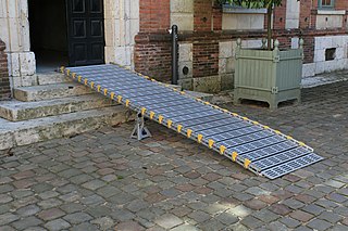
An inclined plane, also known as a ramp, is a flat supporting surface tilted at an angle from the vertical direction, with one end higher than the other, used as an aid for raising or lowering a load. The inclined plane is one of the six classical simple machines defined by Renaissance scientists. Inclined planes are used to move heavy loads over vertical obstacles. Examples vary from a ramp used to load goods into a truck, to a person walking up a pedestrian ramp, to an automobile or railroad train climbing a grade.

<span class="mw-page-title-main">Angle of view (photography)</span> Angular extent of given scene imaged by camera

In photography, angle of view (AOV) describes the angular extent of a given scene that is imaged by a camera. It is used interchangeably with the more general term field of view.

<span class="mw-page-title-main">Golden spiral</span> Self-similar curve related to golden ratio

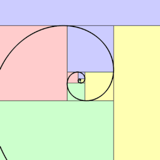
In geometry, a golden spiral is a logarithmic spiral whose growth factor is φ, the golden ratio. That is, a golden spiral gets wider by a factor of φ for every quarter turn it makes.

<span class="mw-page-title-main">Angle of repose</span> Steepest angle at which granular materials can be piled before slumping

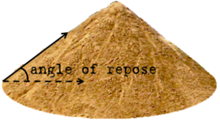
The angle of repose, or critical angle of repose, of a granular material is the steepest angle of descent or dip relative to the horizontal plane on which the material can be piled without slumping. At this angle, the material on the slope face is on the verge of sliding. The angle of repose can range from 0° to 90°. The morphology of the material affects the angle of repose; smooth, rounded sand grains cannot be piled as steeply as can rough, interlocking sands. The angle of repose can also be affected by additions of solvents. If a small amount of water is able to bridge the gaps between particles, electrostatic attraction of the water to mineral surfaces increase the angle of repose, and related quantities such as the soil strength.

<span class="mw-page-title-main">Projectile motion</span> Motion of launched objects due to gravity

Projectile motion is a form of motion experienced by an object or particle that is projected in a gravitational field, such as from Earth's surface, and moves along a curved path under the action of gravity only. In the particular case of projectile motion on Earth, most calculations assume the effects of air resistance are passive and negligible. The curved path of objects in projectile motion was shown by Galileo to be a parabola, but may also be a straight line in the special case when it is thrown directly upward or downward. The study of such motions is called ballistics, and such a trajectory is a ballistic trajectory. The only force of mathematical significance that is actively exerted on the object is gravity, which acts downward, thus imparting to the object a downward acceleration towards the Earth’s center of mass. Because of the object's inertia, no external force is needed to maintain the horizontal velocity component of the object's motion. Taking other forces into account, such as aerodynamic drag or internal propulsion, requires additional analysis. A ballistic missile is a missile only guided during the relatively brief initial powered phase of flight, and whose remaining course is governed by the laws of classical mechanics.

<span class="mw-page-title-main">Tangent half-angle formula</span> Relates the tangent of half of an angle to trigonometric functions of the entire angle

In trigonometry, tangent half-angle formulas relate the tangent of half of an angle to trigonometric functions of the entire angle. The tangent of half an angle is the stereographic projection of the circle through the point at angle onto the line through the angles . Among these formulas are the following:

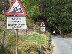
Hillclimbing is a problem faced by railway systems when a load must be carried up an incline. While railways have a great ability to haul very heavy loads, this advantage is only significant when the tracks are fairly level. As soon as the gradients increase, the tonnage that can be hauled is greatly diminished.

<span class="mw-page-title-main">Strike and dip</span> Orientation of a geologic feature

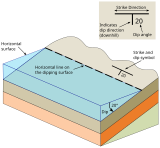
In geology, strike and dip is a measurement convention used to describe the plane orientation or attitude of a planar geologic feature. A feature's strike is the azimuth of an imagined horizontal line across the plane, and its dip is the angle of inclination measured downward from horizontal. They are used together to measure and document a structure's characteristics for study or for use on a geologic map. A feature's orientation can also be represented by dip and dip direction, using the azimuth of the dip rather than the strike value. Linear features are similarly measured with trend and plunge, where "trend" is analogous to dip direction and "plunge" is the dip angle.

<span class="mw-page-title-main">Rifleman's rule</span>

Rifleman's rule is a "rule of thumb" that allows a rifleman to accurately fire a rifle that has been calibrated for horizontal targets at uphill or downhill targets. The rule says that only the horizontal range should be considered when adjusting a sight or performing hold-over in order to account for bullet drop. Typically, the range of an elevated target is considered in terms of the slant range, incorporating both the horizontal distance and the elevation distance, as when a rangefinder is used to determine the distance to target. The slant range is not compatible with standard ballistics tables for estimating bullet drop.

Geomorphometry, or geomorphometrics, is the science and practice of measuring the characteristics of terrain, the shape of the surface of the Earth, and the effects of this surface form on human and natural geography. It gathers various mathematical, statistical and image processing techniques that can be used to quantify morphological, hydrological, ecological and other aspects of a land surface. Common synonyms for geomorphometry are geomorphological analysis, terrain morphometry, terrain analysis, and land surface analysis. Geomorphometrics is the discipline based on the computational measures of the geometry, topography and shape of the Earth's horizons, and their temporal change. This is a major component of geographic information systems (GIS) and other software tools for spatial analysis.

In mathematics, the elasticity or point elasticity of a positive differentiable function f of a positive variable at point a is defined as

There are several equivalent ways for defining trigonometric functions, and the proof of the trigonometric identities between them depend on the chosen definition. The oldest and somehow the most elementary definition is based on the geometry of right triangles. The proofs given in this article use this definition, and thus apply to non-negative angles not greater than a right angle. For greater and negative angles, see Trigonometric functions.

In geometry, the Philo line is a line segment defined from an angle and a point inside the angle as the shortest line segment through the point that has its endpoints on the two sides of the angle. Also known as the Philon line, it is named after Philo of Byzantium, a Greek writer on mechanical devices, who lived probably during the 1st or 2nd century BC. Philo used the line to double the cube; because doubling the cube cannot be done by a straightedge and compass construction, neither can constructing the Philo line.

<span class="mw-page-title-main">Biarc</span>

A biarc is a smooth curve formed from two circular arcs. In order to make the biarc smooth, the two arcs should have the same tangent at the connecting point where they meet.

In mathematics and statistics, a circular mean or angular mean is a mean designed for angles and similar cyclic quantities, such as times of day, and fractional parts of real numbers.

<span class="mw-page-title-main">Ffordd Pen Llech</span>

Ffordd Pen Llech is a public road in the town of Harlech which lies within Snowdonia National Park, North Wales. It was once considered the steepest street in the world, although that title reverted to the previous holder Baldwin Street on 8 April 2020.

References

  1. Michael W. Sayers; Thomas D. Gillespie; William D.O. Paterson (January 1986). "Directives pour la mesure de l'uni des routes et l'étalonnage des appareils" (PDF) (in French). World Bank. p. 2. L'indice IRI est une mesure de l'uni des routes standardisée, apparentée aux mesures obtenues à l'aide des appareils de type-réponse. Les unités recommandées sont : les mètres par kilomètres (m/km) =millimètres par mètres (mm/m) = pente x 1000.
  2. ZEMBA, Baowendzooda Joël (July 2015). "ETUDE D'AVANT-PROJET DETAILLE DE L'AMENAGEMENT D'UN PERIMETRE IRRIGUE DE 100 HA À BAGRE EN RIVE DROITE DU NAKANBE (BURKINA FASO)" (in French). p. 37. Archived from the original on 19 November 2023. Pente longitudinale i (m/km ou ‰): 0.4
  3. Strom, Steven; Nathan, Kurt; Woland, Jake (2013). "Slopes expressed as ratios and degrees". Site Engineering for Landscape Architects (6th ed.). Wiley Publishing. p. 71. ISBN   978-1118090862.
  4. "Traffic signs". www.gov.uk. The Highway Code - Guidance. Retrieved 26 March 2016.
  5. "Crawler-Transporter". NASA. 21 April 2003. Archived from the original on 1 June 2020. Retrieved 18 June 2020.
  6. "Countdown! NASA Launch Vehicles and Facilities" (PDF). NASA. October 1991. pp. 16–17. PMS 018-B, section 3. Archived from the original (PDF) on 27 January 2005. Retrieved 21 August 2013.
  7. A Policy on Geometric Design of Highways and Streets (PDF) (4th ed.). Washington, DC: American Association of State Highway and Transportation Officials. 2001. pp. 507 (design speed), 510 (exhibit 8–1: Maximum grades for rural and urban freeways). ISBN   1-56051-156-7 . Retrieved 11 April 2014.
  8. "Welsh town claims record title for world's steepest street". Guinness World Records. 16 July 2019.
  9. "Kiwi climb: Hoofing up the world's steepest street". CNN.com.
  10. "Baldwin street in New Zealand reinstated as the world's steepest street". Guinness World Records. 8 April 2020.
  11. "The Real Top 10 List of Steepest Streets in San Francisco". 7x7.
  12. 1 2 "General Information". San Francisco Metropolitan Transportation Agency. Archived from the original on 3 December 2016. Retrieved 20 September 2016.
  13. "Canton Avenue, Beechview, PA". Post Gazette.
  14. "The steepest road on Earth takes no prisoners". Wired. Autopia. December 2010.
  15. "Top five funicular railways". Sydney Morning Herald.
  16. "A wonderful railway". The Register . Adelaide, Australia. 2 March 1920. p. 5. Retrieved 13 February 2013 via National Library of Australia.
  17. "The New Pöstlingberg Railway" (PDF). Linz Linien GmbH. 2009. Archived from the original (PDF) on 22 July 2011. Retrieved 6 January 2011.
  18. "Pantele din Iaşi pun probleme ofertanţilor" (in Romanian). 5 March 2019.
  19. "Return of the (modern) streetcar – Portland leads the way" (Press release). Tramways & Urban Transit. Light Rail Transit Association. October 2001. Archived from the original on 27 September 2013. Retrieved 15 December 2018.
  20. "Boston's Light Rail Transit Prepares for the Next Hundred Years" (PDF). onlinepubs.trb.org. Retrieved 23 February 2021.
  21. Daniel, Mac (11 November 2005). "Lechmere, Science Park stations reopen". Boston.com. Archived from the original on 6 March 2007. Retrieved 23 February 2021.
  22. "Il Piano Tecnologico di RFI" (PDF). Collegio Ingegneri Ferroviari Italiani. 15 October 2018. Retrieved 23 May 2019.
  23. "Madisonview". www.oldmadison.com. Retrieved 7 April 2017.
  24. "The Matheran Light Railway (extension to the Mountain Railways of India)". UNESCO World Heritage Centre.
  25. Martin, Bruno (September 2005). "Durban-Pietermaritzburg main line map and profile" (PDF). Transport in South and Southern Africa. Retrieved 7 April 2017.
  26. Valley Heights railway station
  27. "Improving the Southeast Expressway: A Conceptual Plan" (PDF). www.bostonmpo.org. Retrieved 24 February 2021.