The population of Budapest was 1,735,041 on 1 January 2013.[1] According to the 2011 census, the Budapest metropolitan area was home to 2,530,167 people and the Budapest commuter area (real periphery of the city) had 3.3 million inhabitants.[2] The Hungarian capital is the largest in the Pannonian Basin and the ninth largest in the European Union. Budapest is also the primate city of Hungary and some neighbouring territories.[3]
After the conquest of the Carpathian Basin one of the main Hungarian (Magyar) tribes, named Megyer, settled in the present-territory of Budapest, more exactly on both banks of the river Danube in Békásmegyer („Frog's Megyer”) and Káposztásmegyer („Cabbage's Megyer”), now high-rise housing estates of the city. Endonym „Magyar” (for Hungarians) is originated from the tribe name „Megyer”.[7][8] According to the 1494-95 medieval census, was implemented by the Hungarian Royal Treasury,[9] the present-territory of Budapest had Hungarian majority. The native population fled from the area during the Ottoman wartimes, in the 17th century Buda was home to mainly Turkish and South Slavic population. Many of them died in the Battle of Buda in 1686, survivors were expelled. In the late-17th and the early-18th century Buda, Óbuda and Pest was settled by Germans from Southern Germany and the Rhineland. The proportion of Hungarians rose gradually since the late 18th century, overtook Germans around the unification in 1873. Between 1787 and 1910 number of ethnic Hungarians rose from 2.3 million to 10.2 million due to population explosion, generated by the resettlement of the Great Hungarian Plain and Lower Hungary by Hungarian settlers from the relatively overpopulated northern and western counties of the Kingdom of Hungary. Hungarian villages and market towns become overcrowded, Budapest has become the main destination of the rural surplus population due to industrialisation.[10] Hungarians increased their number from 200,000[4] to 2,000,000[11] in Budapest between 1880 and 1980. By the end of the World War II, Budapest can be described as an ethnically homogeneous city.
According to the 2011 census the total population of Budapest was 1,729,040, of whom there were 1,397,851 (80.8%) Hungarians, 19,530 (1.1%) Romani, 18,278 (1.0%) Germans, 6,189 (0.4%) Romanians, 4,692 (0.3%) Chinese and 2,581 (0.1%) Slovaks. 301,943 people (17.5%) did not declare their ethnicity. Excluding these people Hungarians made up 98.0% of the total population. In Hungary people can declare more than one ethnicity, so the sum of ethnicities is higher than the total population.[12][13]
Languages
According to the 2011 census, 1,712,153 people (99.0%) speak Hungarian, of whom 1,692,815 people (97.9%) speak it as a first language, while 19,338 people (1.1%) speak it as a second language. Other spoken (foreign) languages were: English (536,855 speakers, 31.0%), German (266,249 speakers, 15.4%), French (56,208 speakers, 3.3%) and Russian (54,613 speakers, 3.2%).[13]
Budapest is the home to one of the most populous Christian communities in Central Europe, numbering 698,521 people (40.4%) in 2011. The Hungarian capital is also the home of the largest Calvinist community on Earth. Hungarian Calvinists increased their number from 13,008 (4.8%) to 224,169 (12.6%) between 1870 and 2001 due to internal migration, triggered by higher fertility than other denominations. However the 2011 census showed decline in all religious groups - the number of Calvinists fell to 146,756 people (8.5%). Hungarian Roman Catholics remained the most populous separate group with 501,117 people (28.9%). Moreover, the most recent census was the first one in the city's history when the share of people attached to religious groups was below 50%.
Judaism also was a significant religion in Budapest, numbered 215,512 people (23.2%) in 1920, but they dropped to a smaller group (80,000 people, 4.2% in 2018) due to the Holocaust, secularization, and atheism, the huge ratio to convert to Christianity, and assimilation and intermarriages with non-Jews after 1945, and the immigration to Israel. Religious Hungarian Jews has had the lowest fertility in Hungary, natural decline began in the 1920s. The community is still very aged with 52.6 years median age, about ten years higher than Catholics (41.7 years) and Calvinists (42.5 years).[13][18][19][20][21][22]
According to the 2001 census, majority of the population of Budapest is originated from the Hungarian countryside. 230,307 people (13%) are from the Great Plain, 170,406 (9.6%) from Transdanubia, 93,665 (5.3%) from Pest county and 90,228 people (5.1%) are from Northern Hungary. Budapest is the hometown to 822,663 people (46.3%), while 87,746 people (4.9%) was born outside the present-day borders of Hungary.[23] (See: Treaty of Trianon and Treaty of Paris)
According to the 2011 census, 1,600,585 people (92.6%) were born in Hungary, 126,036 people (7.3%) outside Hungary while the birthplace of 2,419 people (0.1%) was unknown.[13]
The spatial distribution of political parties is very various. Fidesz is outstanding in the conservativemiddle and upper middle class (high income) characteristic Buda (parts of the 1st, 2nd, 3rd, 11th and 12th districts) and in the garden estates (former suburbs, annexed by the city) of Pest (parts of the 14th, 15th, 16th and 17th districts). Unity and Jobbik are relatively strong in the working class and lower middle class characteristic neighbourhoods (parts of the 4th, 10th, 13th, 14th, 15th, 18th, 19th, 20th and 21st districts) while LMP is remarkable in the partly run-down, inner (more liberal) blocks (parts of 6th, 7th, 8th and 9th districts).[26]
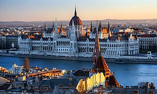
Budapest is the capital and most populous city of Hungary. It is the ninth-largest city in the European Union by population within city limits and the largest city on the Danube river; the city has an estimated population of 1,752,286 over a land area of about 525 square kilometres. Budapest, which is both a city and county, forms the centre of the Budapest metropolitan area, which has an area of 7,626 square kilometres and a population of 3,303,786. It is a primate city, constituting 33% of the population of Hungary.
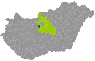
Pest is a county (vármegye) in central Hungary. It covers an area of 6,393.14 square kilometres (2,468.41 sq mi), and has a population of 1,213,090 (2009). It surrounds the national capital Budapest and the majority of the county's population live in the suburbs of Budapest. It shares borders with Slovakia and the Hungarian counties Nógrád, Heves, Jász-Nagykun-Szolnok, Bács-Kiskun, Fejér, and Komárom-Esztergom. The River Danube flows through the county. The capital of Pest County is Budapest, but it is planned to completely separate the capital from the county at least until 2020, as it loses catch-up aids from the European Union because of the high development of Budapest.
Nógrád is a county of Hungary. It sits on the northern edge of Hungary and borders Slovakia.
The ethno-linguistic composition of Austria-Hungary according to the census of 31 December 1910 was as follows:
Tolna is an administrative county in present Hungary as it was of the former Kingdom of Hungary. It lies in central Hungary, on the west bank of the river Danube. It shares borders with the Hungarian counties Somogy, Fejér, Bács-Kiskun, and Baranya. The capital of Tolna county is Szekszárd. Its area is 3703 km2.
Fejér is an administrative county in central Hungary. It lies on the west bank of the river Danube and nearly touches the eastern shore of Lake Balaton. It shares borders with the Hungarian counties Veszprém, Komárom-Esztergom, Pest, Bács-Kiskun, Tolna and Somogy. The capital of Fejér county is Székesfehérvár.
Veszprém is an administrative county (vármegye) in Hungary. Veszprém is also the name of the capital city of Veszprém county.
Csongrád-Csanád is the name of an administrative county in southern Hungary, straddling the river Tisza, on the border with Serbia and Romania. It shares borders with the Hungarian counties Bács-Kiskun County, Jász-Nagykun-Szolnok County and Békés. The administrative centre of Csongrád-Csanád county is Szeged. The county is also part of the Danube–Criș–Mureș–Tisa Euroregion.
Győr-Moson-Sopron is an administrative county in north-western Hungary, on the border with Slovakia and Austria (Burgenland). It shares borders with the Hungarian counties Komárom-Esztergom, Veszprém and Vas. The capital of Győr-Moson-Sopron county is Győr. The county is a part of the Centrope Project.
Bács-Kiskun is a county located in southern Hungary. It was created as a result of World War II, merging the prewar Bács-Bodrog and the southern parts of Pest-Pilis-Solt-Kiskun counties. With an area of 8,445 km2, Bács-Kiskun is the largest county in the country, slightly larger than Cyprus. The terrain is mostly flat with slight emergences around Baja. The county seat and largest city of Bács-Kiskun is Kecskemét.
Heves county lies in northern Hungary, between the right bank of the river Tisza and the Mátra and Bükk mountains. It shares borders with the Hungarian counties Pest, Nógrád, Borsod-Abaúj-Zemplén and Jász-Nagykun-Szolnok. Eger is the county seat.
Jász-Nagykun-Szolnok is the name of an administrative county in Hungary. It lies in central Hungary and shares borders with the Hungarian counties Pest, Heves, Borsod-Abaúj-Zemplén, Hajdú-Bihar, Békés, Csongrád, and Bács-Kiskun. The rivers Tisza and Körös flow through the county. The capital of Jász-Nagykun-Szolnok county is Szolnok. Its area is 5582 km². The county is named after the Ossetians (Jasz) and Cumans (Kun) who settled there, along with Szolnok. The county was part of the Danube–Criș–Mureș–Tisa Euroregion between 1997 and 2004.
Soltvadkert is a town in Bács-Kiskun County in Hungary with approximately 8,000 inhabitants. The former name of the town is Vadkert. It is surrounded by several areas of Kiskunság National Park and Lake Vadkert.
Bušovce is a village and municipality in Kežmarok District in the Prešov Region of northern central Slovakia.
Spišská Belá is a town in the Kežmarok District in the Prešov Region in Spiš in northern Slovakia. Prior to World War I, it was in Szepes county in the Kingdom of Hungary.
Podhorany is a village and municipality in Kežmarok District in the Prešov Region of north Slovakia.
Őrbottyán is a town in Pest county, Hungary.
Érd is a district in south-western part of Pest County. Érd is also the name of the town where the district seat is found. The district is located in the Central Hungary Statistical Region.
Gyál is a district in central-southern part of Pest County. Gyál is also the name of the town where the district seat is found. The district is located in the Central Hungary Statistical Region.
Pilisvörösvár is a district in north-western part of Pest County. Pilisvörösvár is also the name of the town where the district seat is found. The district is located in the Central Hungary Statistical Region.
References
Károly Kocsis (DSc, University of Miskolc) – Zsolt Bottlik (PhD, Budapest University) – Patrik Tátrai: Etnikai térfolyamatok a Kárpát-medence határon túli régióiban, Magyar Tudományos Akadémia (Hungarian Academy of Sciences) – Földrajtudományi Kutatóintézet (Academy of Geographical Studies); Budapest; 2006.; ISBN963-9545-10-4, CD Atlas
Gábor Preisich: Budapest városépítésének története, Műszaki Könyvkiadó, Budapest, 1998, ISBN963-16-1467-0
1 2 Budapest statisztikai évkönyve 1944-1946 (Statistical Yearbook of Budapest, 1944-1946), p. 12, Hungarian Central Statistical Office
↑ Katalin Csapó - Katalin Karner: Budapest az egyesítéstől az 1930-as évekig (Budapest from the unification to the 1930s), Budapest, 1999, HU ISBN963-9001-36-8
↑ Budapest székes főváros Statisztikai és Közigazgatási Évkönyve 1921-1924 (Statistical Yearbook of Budapest, 1921-1924), p. 38, Hungarian Central Statistical Office
↑ Budapest statisztikai évkönyve 1943 (Statistical Yearbook of Budapest, 1943), p. 32, Hungarian Central Statistical Office
↑ 1949. évi népszámlálás (1949 census), 9. Demográfiai eredmények, Hungarian Central Statistical Office, 1950, p. 324
↑ 1949. évi népszámlálás (1949 census), vallási adatok településenként, Hungarian Central Statistical Office, 1995, p. 17
This page is based on this Wikipedia article Text is available under the CC BY-SA 4.0 license; additional terms may apply. Images, videos and audio are available under their respective licenses.