
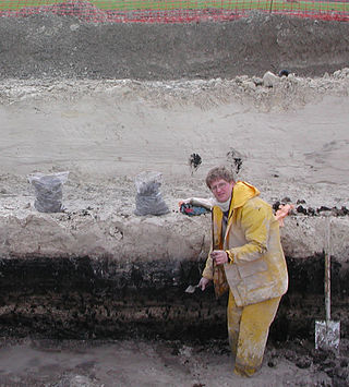
In archaeology, excavation is the exposure, processing and recording of archaeological remains. An excavation site or "dig" is the area being studied. These locations range from one to several areas at a time during a project and can be conducted over a few weeks to several years.

An archaeological site is a place in which evidence of past activity is preserved, and which has been, or may be, investigated using the discipline of archaeology and represents a part of the archaeological record. Sites may range from those with few or no remains visible above ground, to buildings and other structures still in use.
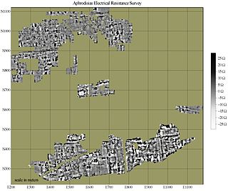
In archaeology, geophysical survey is ground-based physical sensing techniques used for archaeological imaging or mapping. Remote sensing and marine surveys are also used in archaeology, but are generally considered separate disciplines. Other terms, such as "geophysical prospection" and "archaeological geophysics" are generally synonymous.
Planning Policy Guidance 16: Archaeology and Planning commonly abbreviated as PPG 16, was a document produced by the UK Government to advise local planning authorities in England and Wales on the treatment of archaeology within the planning process. It was introduced in November 1990 following public outcry after a number of high-profile scandals such as the threatened destruction of the Rose Theatre in London by developers. It replaced the earlier Circular 8/87 which was criticized for being ill-focused in both practical and geographical terms. On 23 March 2010 the Government published 'Planning Policy Statement 5:Planning and the Historic Environment' replacing and cancelling PPG16 and PPG15 which had dealt with the rest of the historic environment.

Trial trenching is a rapid and relatively inexpensive method of archaeological evaluation used to estimate the archaeological potential of a site.
In British archaeology a watching brief is a method of preserving archaeological remains by record in the face of development threat. An archaeologist is employed by the developer to monitor the excavation of foundation and service trenches, landscaping and any other intrusive work. The developer undertakes to give the archaeologist sufficient time to identify and record any archaeological finds and features; however, the arrangement is rarely satisfactory for either party.
Aerial archaeology is the study of archaeological remains by examining them from a higher altitude. In present day, this is usually achieved by satellite images or through the use of drones.

Cropmarks or crop marks are a means through which sub-surface archaeological, natural and recent features may be visible from the air or a vantage point on higher ground or a temporary platform. Such marks, along with parch marks, soil marks and frost marks, can reveal buried archaeological sites that are not visible from the ground.

Stratigraphy is a key concept to modern archaeological theory and practice. Modern excavation techniques are based on stratigraphic principles. The concept derives from the geological use of the idea that sedimentation takes place according to uniform principles. When archaeological finds are below the surface of the ground, the identification of the context of each find is vital in enabling the archaeologist to draw conclusions about the site and about the nature and date of its occupation. It is the archaeologist's role to attempt to discover what contexts exist and how they came to be created. Archaeological stratification or sequence is the dynamic superimposition of single units of stratigraphy, or contexts.
Geoarchaeology is a multi-disciplinary approach which uses the techniques and subject matter of geography, geology, geophysics and other Earth sciences to examine topics which inform archaeological knowledge and thought. Geoarchaeologists study the natural physical processes that affect archaeological sites such as geomorphology, the formation of sites through geological processes and the effects on buried sites and artifacts post-deposition. Geoarchaeologists' work frequently involves studying soil and sediments as well as other geographical concepts to contribute an archaeological study. Geoarchaeologists may also use computer cartography, geographic information systems (GIS) and digital elevation models (DEM) in combination with disciplines from human and social sciences and earth sciences. Geoarchaeology is important to society because it informs archaeologists about the geomorphology of the soil, sediment, and rocks on the buried sites and artifacts they are researching. By doing this, scientists are able to locate ancient cities and artifacts and estimate by the quality of soil how "prehistoric" they really are. Geoarchaeology is considered a sub-field of environmental archaeology because soil can be altered by human behavior, which archaeologists are then able to study and reconstruct past landscapes and conditions.

In archaeology, survey or field survey is a type of field research by which archaeologists search for archaeological sites and collect information about the location, distribution and organization of past human cultures across a large area. Archaeologists conduct surveys to search for particular archaeological sites or kinds of sites, to detect patterns in the distribution of material culture over regions, to make generalizations or test hypotheses about past cultures, and to assess the risks that development projects will have adverse impacts on archaeological heritage. The surveys may be: (a) intrusive or non-intrusive, depending on the needs of the survey team and; (b) extensive or intensive, depending on the types of research questions being asked of the landscape in question. Surveys can be a practical way to decide whether or not to carry out an excavation, but may also be ends in themselves, as they produce important information about past human activities in a regional context.
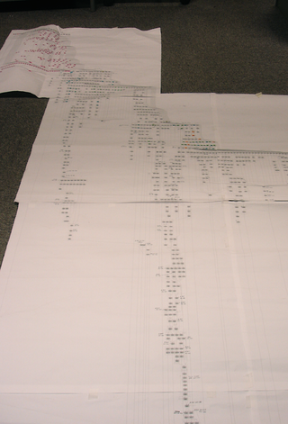
The Harris matrix is a tool used to depict the temporal succession of archaeological contexts and thus the sequence of depositions and surfaces on a 'dry land' archaeological site, otherwise called a 'stratigraphic sequence'. The matrix reflects the relative position and stratigraphic contacts of observable stratigraphic units, or contexts. It was developed in 1973 in Winchester, England, by Dr. Edward C. Harris.
Exploration geophysics is an applied branch of geophysics and economic geology, which uses physical methods at the surface of the Earth, such as seismic, gravitational, magnetic, electrical and electromagnetic, to measure the physical properties of the subsurface, along with the anomalies in those properties. It is most often used to detect or infer the presence and position of economically useful geological deposits, such as ore minerals; fossil fuels and other hydrocarbons; geothermal reservoirs; and groundwater reservoirs.
In archaeology, natural is a term to denote a layer (stratum) in the stratigraphic record where there is no evidence of human impact on the environment. While there may be "natural" layers interbedded with archaeologically interesting layers, such as when a site was abandoned for long periods between occupations, the top of the natural layer below which there is no anthropogenic activity on site, and thus where the archaeological record begins, is the point to terminate digging. Usually it is the underlying geological makeup of the site that was formed by geologic processes. It is the goal of complete excavation to remove the entirety of the archaeological record all the way to the "natural", leaving only the natural deposits of pre-human activity on site.

Gatecliff Rockshelter (26NY301) is a major archaeological site in the Great Basin area of the western United States that provides remarkable stratigraphy; it has been called the "deepest archaeological rock shelter in the Americas". Located in Mill Canyon of the Toquima Range in the Monitor Valley of central Nevada, Gatecliff Rockshelter has an elevation of 7,750 feet (2,360 m). David Hurst Thomas discovered Gatecliff Rockshelter in 1970 and began excavations in 1971. Full scale excavations occurred at Gatecliff Rockshelter for about seven field seasons in which nearly 33 feet (10 m) of sediments were exposed for a well-defined stratigraphic sequence. The well-preserved artifacts and undisturbed sediments at Gatecliff Rockshelter provides data and information have been applied to a range of research topics. Based on the analysis of the artifacts at Gatecliff Rockshelter, it can be determined that it was most likely a short-term field camp throughout prehistory. The latest evidence for human usage at Gatecliff occurs between ca. 5500 B.P. to 1250 B.P.

Vinovia or Vinovium was a Roman fort and settlement situated just over 1 mile (1.6 km) to the north of the town of Bishop Auckland on the banks of the River Wear in County Durham, England. The fort was the site of a hamlet until the late Middle Ages, but the modern-day village of Binchester is about 2 miles (3 km) to the east, near Spennymoor. The ruins are now known as the Binchester Roman Fort.

Archaeology or archeology is the study of human activity through the recovery and analysis of material culture. The archaeological record consists of artifacts, architecture, biofacts or ecofacts, sites, and cultural landscapes. Archaeology can be considered both a social science and a branch of the humanities. It is usually considered an independent academic discipline, but may also be classified as part of anthropology, history or geography.
Remote sensing techniques in archaeology are an increasingly important component of the technical and methodological tool set available in archaeological research. The use of remote sensing techniques allows archaeologists to uncover unique data that is unobtainable using traditional archaeological excavation techniques.

Near-surface geophysics is the use of geophysical methods to investigate small-scale features in the shallow subsurface. It is closely related to applied geophysics or exploration geophysics. Methods used include seismic refraction and reflection, gravity, magnetic, electric, and electromagnetic methods. Many of these methods were developed for oil and mineral exploration but are now used for a great variety of applications, including archaeology, environmental science, forensic science, military intelligence, geotechnical investigation, treasure hunting, and hydrogeology. In addition to the practical applications, near-surface geophysics includes the study of biogeochemical cycles.

Aerial photograph interpretation is a method of extrapolating geological details of the ground surface from aerial images. It allows geologists to analyze the distinguishing geological features and structures, plant cover, past history of the site, soil properties, and topography of the study area. It is crucial in the early stage of a geological mapping as it is less time-consuming and offers important data at a minimal price. It is also commonly used in other industries such as forest management, environmental science, disciplines of engineering, and investigating aviation accidents.